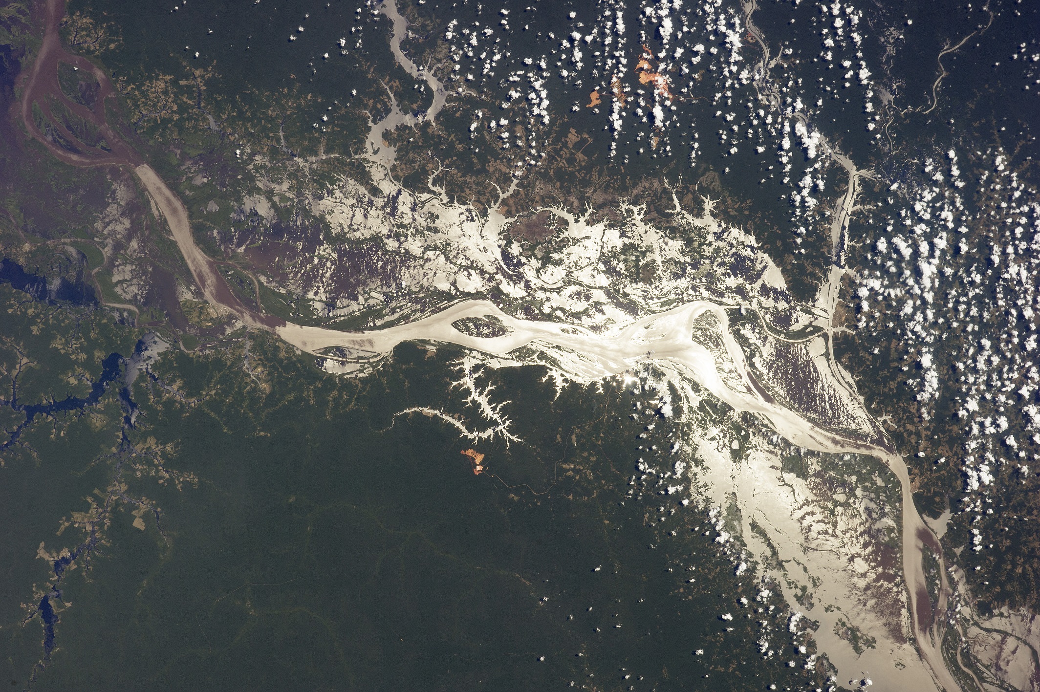
The Amazon River near Lago do Erepecu (north of this image) in 2014. Credit: NASA
The Amazon River is a heck of a big tributary. Besides being one of the LONGEST rivers in the world, it also happens to be the WIDEST. While its estimated length of 4,000 miles (6,400 kilometers) puts it under the Nile River, that statistic could be amended as some believe it’s even longer than that.
Nevertheless, its width puts it at a big river that carries more volume than the Nile. We have a few more facts about the Amazon below.
According to Extreme Science, even during the dry season it is about 6.8 miles (11 kilometers) wide, which is still a respectable width. When things get rainy, however, that’s when stuff really begins to open up. It more than doubles its width to 24.8 miles (40 kilometers).
If that’s enough for you, consider the amount of land it covers. Dry season, Extreme Science says, sees it at 42,471 square miles (110,000 square kilometers), or roughly the land area of Cuba. That astonishing statistic triples during the wet season, when it reaches 135,135 square miles (350,000 square kilometers) — about approximate to Germany’s size.
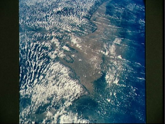
Mouth of the Amazon River as seen from STS-58. Credit: NASA
All of this makes the South American river the largest drainage system in the world, according to Encyclopedia Britannica. Its recorded source is in the Andes Mountains and it flows down to its Atlantic Ocean mouth off the coast of Brazil. But as we’ve noted before, there’s controversy both to its source and to its actual length.
The Amazon basin (the areas that are affected by the river) cover a good portion of South America, the encyclopedia adds: Brazil, Peru, Columbia, Ecuador, Bolivia and Venezuela. But it’s Brazil that has most of the basin and two-thirds of the stream.
Aboriginals in the region have explored the river for centuries, but its name comes from European exploration of the river, the encyclopedia says. “Amazon” is a reference from Europe’s first reported explorer, Spanish soldier Francisco de Orellana, who said the fierce female warriors in battle in the area reminded him of Amazons in Greek mythology.
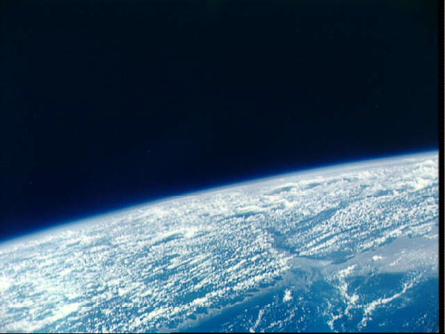
Mouth of Amazon River, Brazil as seen from the Gemini 9-A spacecraft. Credit: NASA
Many of these statistics could change if the source of the Amazon River is also changed. National Geographic says there at least six possible origin points, based on methods ranging from satellite observation to GPS to “ground truth” examinations. You can see more details about the ongoing quest in this article.
Universe Today has articles on the longest river and Europe’s longest river. Astronomy Cast has an episode on Earth you should watch.
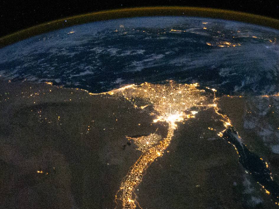
The Nile River and Delta, viewed at night by the Expedition 25 crew on Oct. 28, 2010. Credit: NASA
Planet Earth boasts some very long rivers, all of which have long and honored histories. The Amazon, Mississippi, Euphrates, Yangtze, and Nile have all played huge roles in the rise and evolution of human societies. Rivers like the Danube, Seine, Volga and Thames are intrinsic to the character of some of our most major cities.
But when it comes to the title of which river is longest, the Nile takes top billing. At 6,583 km (4,258 miles) long, and draining in an area of 3,349,000 square kilometers, it is the longest river in the world, and even the longest river in the Solar System. It crosses international boundaries, its water is shared by 11 African nations, and it is responsible for the one of the greatest and longest-lasting civilizations in the world.
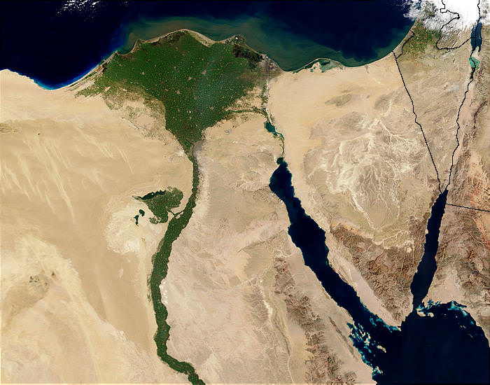
Officially, the Nile begins at Lake Victoria – Africa’s largest Great Lake that occupies the border region between Tanzania, Uganda and Kenya – and ends in a large delta and empties into the Mediterranean Sea. However, the great river also has many tributaries, the greatest of which are the Blue Nile and White Nile rivers.
The White Nile is the source of the majority of the Nile’s water and fertile soil, and originates from Africa’s Great Lakes region of Central Africa (a group that includes Lake Victoria, Edward, Tanganyika, etc.). The Blue Nile starts at Lake Tana in Ethiopia, and flows north-west to where it meets the Nile near Khartoum, Sudan.
Nile Delta from space by the MODIS sensor on the Terra satellite. Credit: Jacques Descloitres/NASA/GSFC
The northern section of the Nile flows entirely through the Sudanese Desert to Egypt. Historically speaking, most of the population and cities of these two countries were built along the river valley, a tradition which continues into the modern age. In addition to the capitol cities of Juba, Khartoum, and Cairo, nearly all the cultural and historical sites of Ancient Egypt are to be found along the riverbanks.
The Nile was a much longer river in ancient times. Prior to the Miocene era (ca. 23 to 5 million years ago), Lake Tangnayika drained northwards into the Albert Nile, making the Nile about 1,400 km. That portion of the river became blocked by the bulk of the formation of the Virunga Mountains through volcanic activity.
Between 8000 and 1000 B.C.E., there was also a third tributary called the Yellow Nile that connected the highlands of eastern Chad to the Nile River Valley. Its remains are known as the Wadi Howar, a riverbed that passes through the northern border of Chad and meets the Nile near the southern point of the Great Bend – the region that lies between Khartoum and Aswan in southern Egypt where the river protrudes east and west before traveling north again.
The Nile, as it exists today, is thought to be the fifth river that has flowed from the Ethiopian Highlands. Some form of the Nile is believed to have existed for 25 million years. Satellite images have been used to confirm this, identifying dry watercourses to the west of the Nile that are believed to have been the Eonile.
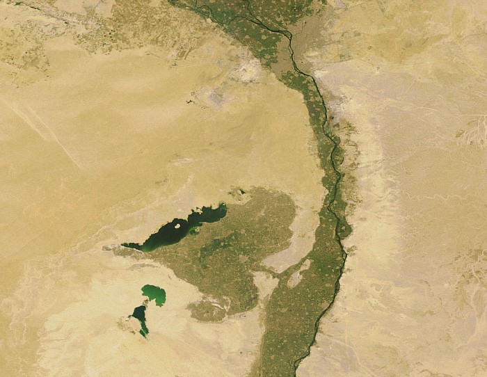
Lake Moeris and Faiyum Oasis, as seen from space, south-west of the Nile Delta and Cairo. Credit: Earth Snapshot
This “ancestral Nile” is believed to be what flowed in the region during the later Miocene, transporting sedimentary deposits to the Mediterranean Sea. During the late-Miocene Era, the Mediterranean Sea became a closed basin and evaporated to the point of being empty or nearly so. At this point, the Nile cut a new course down to a base level that was several hundred meters below sea level.
This created a very long and deep canyon which was filled with sediment, which at some point raised the riverbed sufficiently for the river to overflow westward into a depression to create Lake Moeris southwest of Cairo. A canyon, now filled by surface drift, represents an ancestral Nile called the Eonile that flowed during the Miocene.
Due to their inability to penetrate the wetlands of South Sudan, the headwaters of the Nile remained unknown to Greek and Roman explorers. Hence, it was not until 1858 when John Speke sighted Lake Victoria that the source of the Nile became known to European historians. He reached its southern shore while traveling with Richard Burton on an expedition to explore central Africa and locate the African Great Lakes.
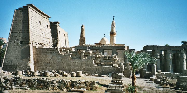
The Temple of Luxor, one of the most important ancient Egyptian cultural monuments, located in southern Egypt along the Nile. Credit: Wikipedia/Creative Commons
Believing he had found the source of the Nile, he named the lake after Queen Victoria, the then-monarch of the United Kingdom. Upon learning of this, Burton was outraged that Speke claimed to have found the true source of the Nile and a scientific dispute ensued.
This in turn triggered new waves of exploration that sent David Livingstone into the area. However, he failed by pushing too far to the west where he encountered the Congo River. It was not until the Welsh-American explorer Henry Morton Stanley circumvented Lake Victoria during an expedition that ran from 1874 to 1877 that Speke’s claim to have found the source of the Nile was confirmed.
The Nile became a major transportation route during the European colonial period. Many steamers used the waterway to travel through Egypt and south to the Sudan during the 19th century. With the completion of the Suez Canal and the British takeover of Egypt in the 1870s, steamer navigation of the river became a regular occurrence and continued well into the 1960s and the independence of both nations.
Today, the Nile River remains a central feature to Egypt and the Sudan. Its waters are used by all nations that it passes through for irrigation and farming, and its important to the rise and endurance of civilization in the region cannot be underestimated. In fact, the sheer longevity of Egypt’s many ruling dynasties is often attributed by historians to the periodic flows of sediment and nutrients from Lake Victoria to the delta. Thanks to these flows, it is believed, communities along the Nile River never experienced collapse and disintegration as other cultures did.
[/caption]The largest river in the world can be hard to calculate. Many factors come into play: the source, the identification of the mouth, and the measurement of the river length between source and mouth. As a result, the measurements of many rivers are only approximations. So, there has been disagreement whether the Amazon or the Nile is the world’s largest river based on the inclusion of estuaries.
The mouth of a river is hard to determine in cases where the river has a large estuary that gradually widens and opens into the ocean. The source of some rivers starting in farming areas can be difficult to determine, if the river is formed by the confluence of several farm field drainage ditches which only contain water after rain. Similarly, in rivers starting in a chalk area the length of the upper course which is dry varies with how high the water table is. How large a river is between source and mouth may be hard to determine due to issues of map scale. Small scale maps tend to generalize more than large scale maps. In general, length measurements should be based on maps that are large enough scale to show the width of the river, and the path measured is the path a small boat would take down the middle of the river.
Given, and despite, this ambiguity, the Nile has been determined to be the largest river in the world followed by the Amazon and the Yangtze. The Nile is a north-flowing river in North Africa. It is 6,650 km long. It has two major tributaries, the White Nile and the Blue Nile. The Blue Nile is the source of most of the water and fertile soil in the system. The White Nile is longer and rises in central Africa beginning in Rwanda. The two rivers meet near the Sudanese capital of Khartoum. The northern section of the Nile flows almost entirely through desert. Most of the ancient civilizations of the area were centered along the river’s banks. The Nile ends in a large delta that empties into the Mediterranean Sea.
The debate over which is the largest river in the world seems to be over for now. The Nile is 250 km larger than the Amazon. Both rivers have played important roles in the evolution of the civilizations that sprang up around them and will continue to do so for centuries to come.