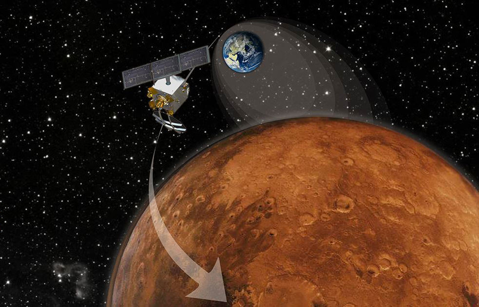
India’s Mars Orbiter Mission (MOM) marked 100 days out from Mars on June 16, 2014 and the Mars Orbit Insertion engine firing when it arrives at the Red Planet on September 24, 2014 after its 10 month interplanetary journey. Credit ISRO
Now less than 25 days from her history making rendezvous with the Red Planet and the critical Mars Orbital Insertion (MOI) engine firing, India’s MOM is in good health!
The Mars Orbiter Mission, or MOM, counts as India’s first interplanetary voyager and the nation’s first manmade object to orbit the 4th rock from our Sun on September 24, 2014 – if all goes well.
MOM was designed and developed by the Indian Space Research Organization (ISRO).
“MOM and its payloads are in good health,” reports ISRO in a new update.
As of today, Aug. 31, MOM has traveled a total distance of over 622 million km in its heliocentric arc towards Mars, says ISRO. It is currently 199 million km away from Earth.
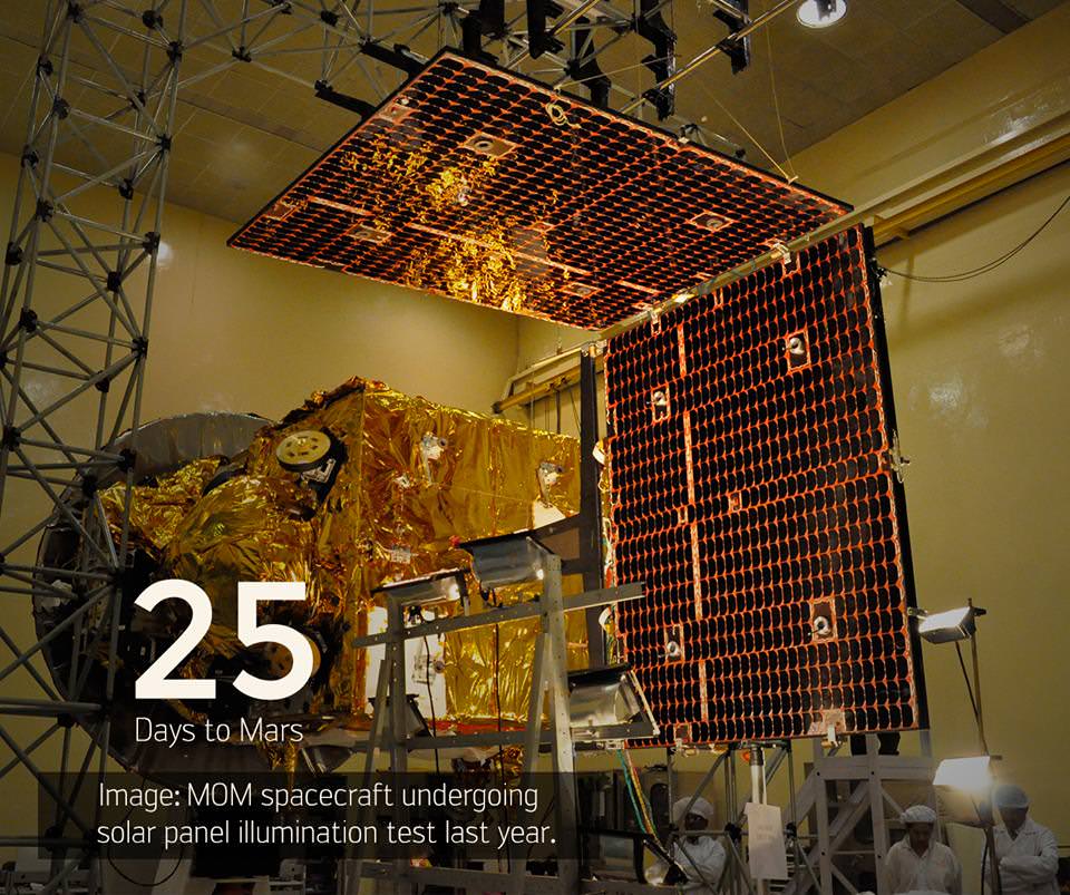
25 Days to Mars Orbit Insertion engine firing for ISRO’s Mars Orbiter Mission (MOM) on Sept. 24, 2014. Prelaunch images show MOM undergoing solar panel illumination tests during 2013 prior to launch. Credit: ISRO
Altogether the probe has completed over 90% of the journey to Mars.
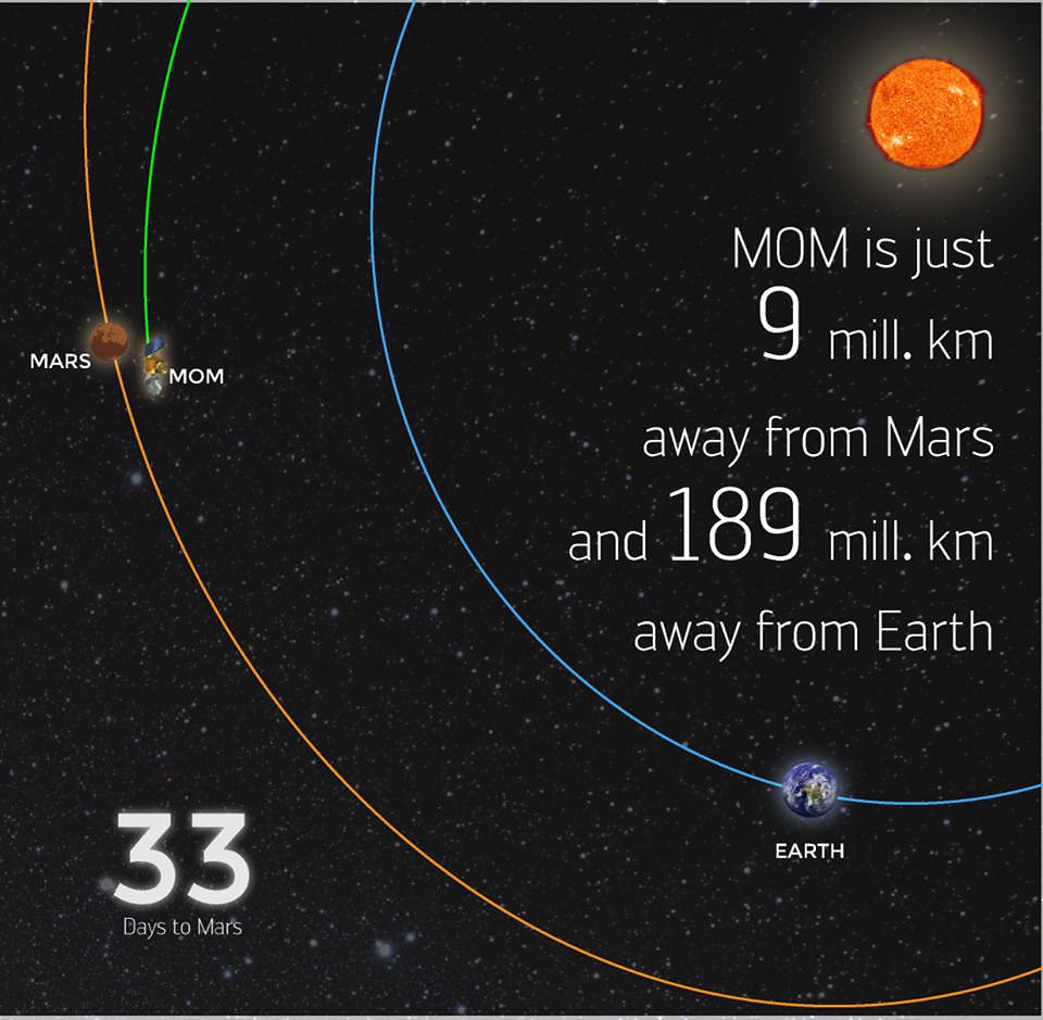
In the past week alone it has traveled over 20 million km and is over 10 million km further from Earth. It is now less than 9 million kilometers away from Mars
Round trip radio signals communicating with MOM now take some 21 minutes.
The 1,350 kilogram (2,980 pound) probe has been streaking through space for nearly ten months.
To remain healthy and accomplish her science mission ahead, the spacecraft must fire the 440 Newton liquid fueled main engine to brake into orbit around the Red Planet on September 24, 2014 – where she will study the atmosphere and sniff for signals of methane.
The do or die MOI burn on September 24, 2014 places MOM into an 377 km x 80,000 km elliptical orbit around Mars.
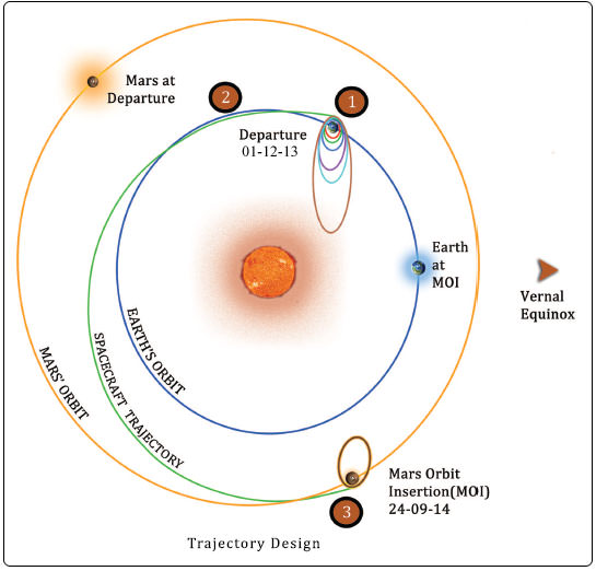
Trans Mars Injection (TMI), carried out on Dec 01, 2013 at 00:49 hrs (IST) moved the spacecraft into the Mars Transfer Trajectory (MTT). With TMI the Earth orbiting phase of the spacecraft ended and the spacecraft is now on a course to encounter Mars after a journey of about 10 months around the Sun. Credit: ISRO
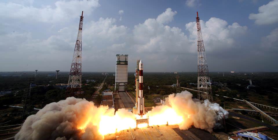
MOM was launched on Nov. 5, 2013 from India’s spaceport at the Satish Dhawan Space Centre, Sriharikota, atop the nations indigenous four stage Polar Satellite Launch Vehicle (PSLV) which placed the probe into its initial Earth parking orbit.
MOM is streaking to Mars along with NASA’s MAVEN orbiter, which arrives a few days earlier on September 21, 2014.
Although MOM’s main objective is a demonstration of technological capabilities, she will also study the planet’s atmosphere and surface.
The probe is equipped with five indigenous instruments to conduct meaningful science – including a tri color imager (MCC) and a methane gas sniffer (MSM) to study the Red Planet’s atmosphere, morphology, mineralogy and surface features. Methane on Earth originates from both geological and biological sources – and could be a potential marker for the existence of Martian microbes.
Stay tuned here for Ken’s continuing MOM, MAVEN, Rosetta, Opportunity, Curiosity, Mars rover and more Earth and planetary science and human spaceflight news.
Clouds on the ground ! The sky seems inverted for a moment ! Blastoff of India’s Mars Orbiter Mission (MOM) on Nov. 5, 2013 from the Indian Space Research Organization’s (ISRO) Satish Dhawan Space Centre SHAR, Sriharikota. Credit: ISRO
ISRO's Mars Orbiter Mission spacecraft is just 9 million km away from Mars as of Aug. 22, 2014. Credit: ISRO
India’s maiden foray to Mars is now just one month out from the Red Planet and closing in fast on the final stages of the history making rendezvous culminating on September 24, 2014.
As of Aug. 22, 2014, the Mars Orbiter Mission, or MOM, was just 9 million kilometers away from Mars and the crucial Mars Orbital Insertion (MOI) engine firing that places India’s first interplanetary voyager into orbit around the 4th planet from the Sun.
MOM was designed and developed by the Indian Space Research Organization’s (ISRO) at a cost of $69 Million and marks India’s maiden foray into interplanetary flight.
So far it has traveled a total distance of 602 million km in its heliocentric arc towards Mars, says ISRO. It is currently 189 million km away from Earth. Round trip radio signals communicating with MOM take 20 minutes and 47 seconds.
After streaking through space for some ten and a half months, the 1,350 kilogram (2,980 pound) MOM probe will fire its 440 Newton liquid fueled main engine to brake into orbit around the Red Planet on September 24, 2014 – where she will study the atmosphere and sniff for signals of methane.
The do or die MOI burn on September 24 places MOM into an 377 km x 80,000 km elliptical orbit around Mars.
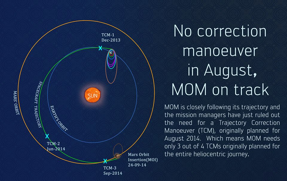
ISRO space engineers are taking care to precisely navigate MOM to keep it on course during its long heliocentric trajectory from Earth to Mars through a series of in flight Trajectory Correction Maneuvers (TMSs).
The last TCM was successfully performed on June 11 by firing the spacecraft’s 22 Newton thrusters for a duration of 16 seconds. TCM-1 was conducted on December 11, 2013 by firing the 22 Newton Thrusters for 40.5 seconds.
Engineers determined that a TCM planned for August was not needed.
The final TCM firing is planned in September 2014.
MOM’s trajectory to Mars. Credit: ISRO
Engineers also completed the checkout of the medium gain antenna in August, “which will be used to communicate with Earth during the critical MOI” maneuver, ISRO reported.
The probe is being continuously monitored by the Indian Deep Space Network (IDSN) and NASA JPL’s Deep Space Network (DSN) to maintain it on course.
Blastoff of the Indian developed Mars Orbiter Mission (MOM) on Nov. 5, 2013 from the Indian Space Research Organization’s (ISRO) Satish Dhawan Space Centre SHAR, Sriharikota. Credit: ISRO
MOM was launched on Nov. 5, 2013 from India’s spaceport at the Satish Dhawan Space Centre, Sriharikota, atop the nations indigenous four stage Polar Satellite Launch Vehicle (PSLV) which placed the probe into its initial Earth parking orbit.
Six subsequent orbit raising maneuvers raised its orbit and culminated with a liquid fueled main engine firing on Dec. 1, 2013. The Trans Mars Injection(TMI) maneuver that successfully placed MOM on its heliocentric trajectory to the Red Planet.
First ever image of Earth Taken by Mars Color Camera aboard India’s Mars Orbiter Mission (MOM) spacecraft while orbiting Earth and before the Trans Mars Insertion firing on Dec. 1, 2013. Image is focused on the Indian subcontinent. Credit: ISRO
MOM is streaking to Mars along with NASA’s MAVEN orbiter, which arrives at Mars about two days earlier.
MOM and MAVEN will join Earth’s fleet of 3 current orbiters from NASA and ESA as well as NASA’s pair of sister surface rovers Curiosity and Opportunity.
If all goes well, India will join an elite club of only four who have launched probes that successfully investigated the Red Planet from orbit or the surface – following the Soviet Union, the United States and the European Space Agency (ESA).
MOM’s main objective is a demonstration of technological capabilities and it will also study the planet’s atmosphere and surface.
The probe is equipped with five indigenous instruments to conduct meaningful science – including a multi color imager and a methane gas sniffer to study the Red Planet’s atmosphere, morphology, mineralogy and surface features. Methane on Earth originates from both geological and biological sources – and could be a potential marker for the existence of Martian microbes.
India’s Mars Orbiter Mission (MOM) marked 100 days out from Mars on June 16, 2014 and the Mars Orbit Insertion engine firing when it arrives at the Red Planet on September 24, 2014 after its 10 month interplanetary journey. Credit ISRO
ISRO is also working to determine if MOM can gather scientific measurements of
Comet C/2013 A1 Siding Spring during an extremely close flyby with the Red Planet on Oct. 19, 2014.
MAVEN and NASA’s other Mars probes will study the comet.
Stay tuned here for Ken’s continuing MOM, MAVEN, Opportunity, Curiosity, Mars rover and more planetary and human spaceflight news.
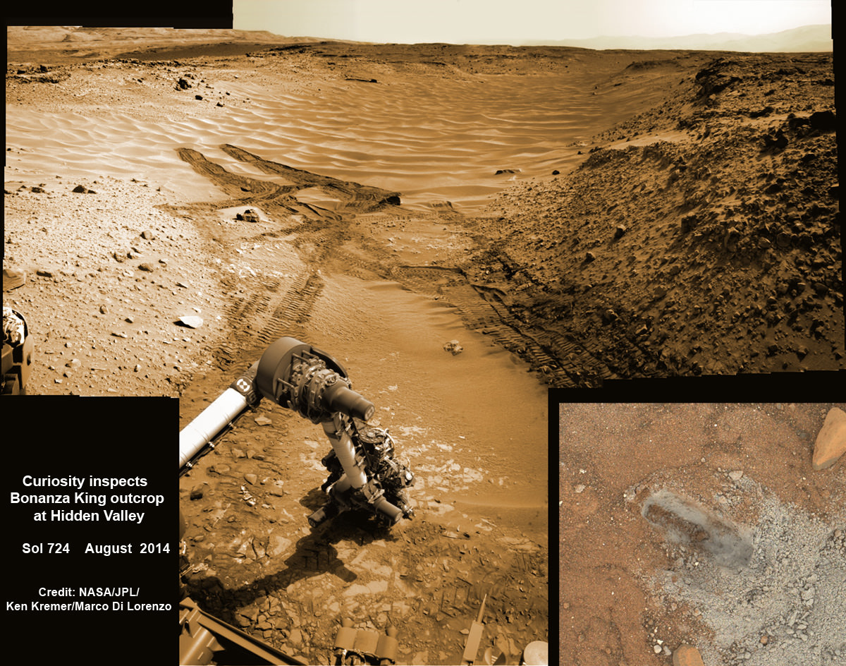
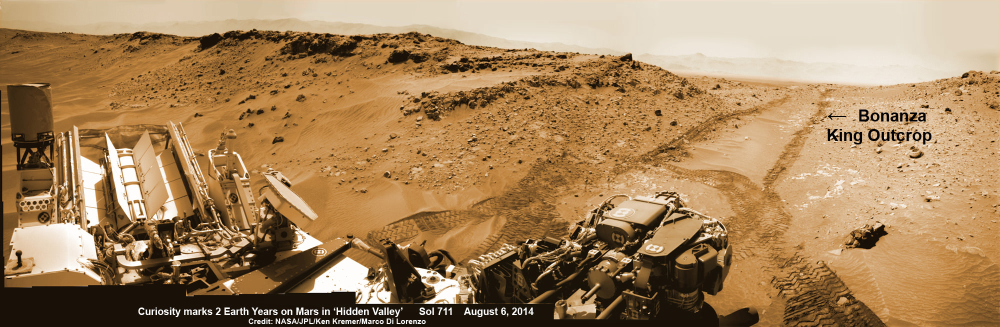
NASA’s Curiosity rover hammers into ‘Bonanza King’ rock outcrop evaluating potential as 4th drill site for sampling at ‘Hidden Valley’ in this photo mosaic view captured on Aug. 20, 2014, Sol 724. Inset MAHLI camera image at right shows resulting rock indentation that caused it to budge and be unsafe for further drilling. Note the background of treacherous sand dune ripples and deep wheel tracks inside Hidden Valley that forced quick exit to alternate route forward. Navcam camera raw images stitched and colorized. Credit: NASA/JPL-Caltech/MSSS/Ken Kremer-kenkremer.com/Marco Di Lorenzo
NASA’s Curiosity rover will skip drilling into a possible 4th rock target and instead resume the trek to Mount Sharp after finding it was unfortunately a slippery rock at the edge of a Martian valley of slippery sands and was therefore too risky to proceed with deep drilling and interior sampling for chemical analysis.
After pounding into the “Bonanza King” rock outcrop on Wednesday, Aug. 20, to evaluate its potential as Curiosity’s 4th drill target on Mars and seeing that it moved on impact, the team decided it was not even safe enough to continue with the preliminary ‘mini-drill’ operation that day.
So they cancelled the entire drill campaign at “Bonanza King” and decided to set the rover loose to drive onwards to her mountain climbing destination.
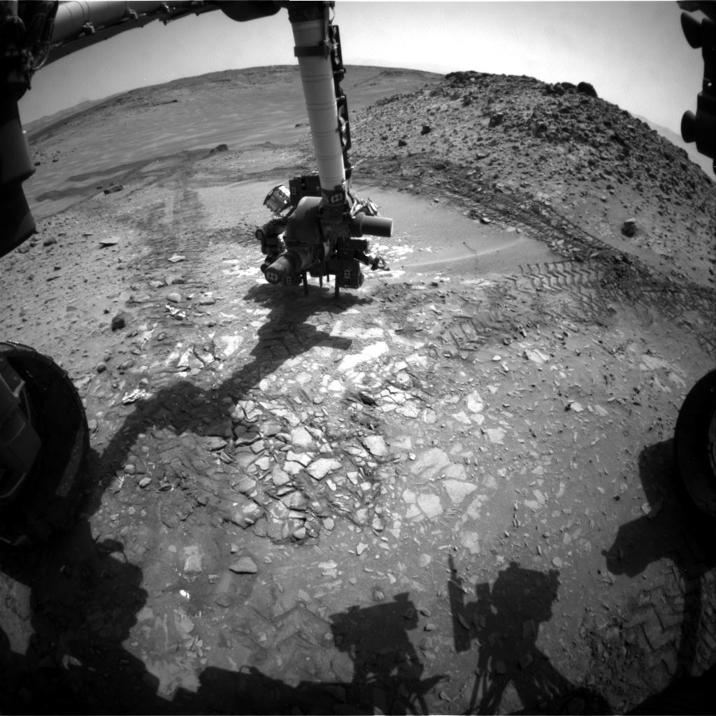
This image from the front Hazcam on NASA’s Curiosity Mars rover shows the rover’s drill in place during a test of whether the rock beneath it, “Bonanza King,” would be an acceptable target for drilling to collect a sample. Subsequent analysis showed the rock budged during the Aug. 19, 2014, test. Credit: NASA/JPL-Caltech
“We have decided that the rocks under consideration for drilling, based on the tests we did, are not good candidates for drilling,” said Curiosity Project Manager Jim Erickson of NASA’s Jet Propulsion Laboratory, Pasadena, California, in a statement.
“Instead of drilling here, we will resume driving toward Mount Sharp.”
Bonanza King was an enticing target because the outcrop possessed thin, white, cross-cutting mineral veins which could indicate that liquid water flowed here in the distant past. Water is a prerequisite for life as we know it.
Loose, unstable rocks pose a prospective hazard to the 1 ton robots hardware and health if they become dislodged during impact by the percussive drill located at the end of the robotic arm.
It’s worth recalling that whirling rocks during the nailbiting Red Planet touchdown two years ago on Aug. 6, 2012, inside Gale Crater are suspected to have slightly damaged Curiosity’s REMS meteorological instrument station.
Each drill target must pass a series of tests. And the prior three at more extensive outcrops all met those criteria. By comparison, imagery showed Bonanza King was clearly part of a much smaller outcrop. See our Bonanza King photo mosaics herein.
NASA’s Curiosity rover looks back to ramp with potential 4th drill site target at ‘Bonanza King’ rock outcrop in ‘Hidden Valley’ in this photo mosaic view captured on Aug. 6, 2014, Sol 711. Inset shows results of brushing on Aug. 17, Sol 722, that revealed gray patch beneath red dust. Note the rover’s partial selfie, valley walls, deep wheel tracks in the sand dunes and distant rim of Gale crater beyond the ramp. Navcam camera raw images stitched and colorized. Credit: NASA/JPL-Caltech/Ken Kremer-kenkremer.com/Marco Di Lorenzo
“One step in the procedure, called “start hole,” uses the hammering action of the percussive drill to create a small indentation in the rock. During this part of the test, the rock moved slightly, the rover sensed that instability in the target, and protective software properly halted the procedure,” according to a NASA statement.
This pale, flat Martian rock thus failed to pass the team’s safety criteria for drilling when it budged.
Bonanza King sits in an bright outcrop on the low ramp at the northeastern end of a spot leading in and out of an area called “Hidden Valley” which lies between Curiosity’s August 2012 landing site in Gale Crater and her ultimate destinations on Mount Sharp which dominates the center of the crater.
Just days ago, the rover team commanded a quick exit from “Hidden Valley” to backtrack out of the dune filled valley because of fears the six wheeled robot could get stuck in slippery sands extending the length of a football field.
“Hidden Valley” looked like it could turn into “Death Valley.”
As Curiosity tested the outcrop, the rover team was simultaneously searching for an alternate safe path forward to the sedimentary layers of Mount Sharp because she arrived at Hidden Valley after recently driving over a field of sharp edged rocks in the “Zabriskie Plateau” that caused further rips and tears in the already damaged 20 inch diameter aluminum wheels.
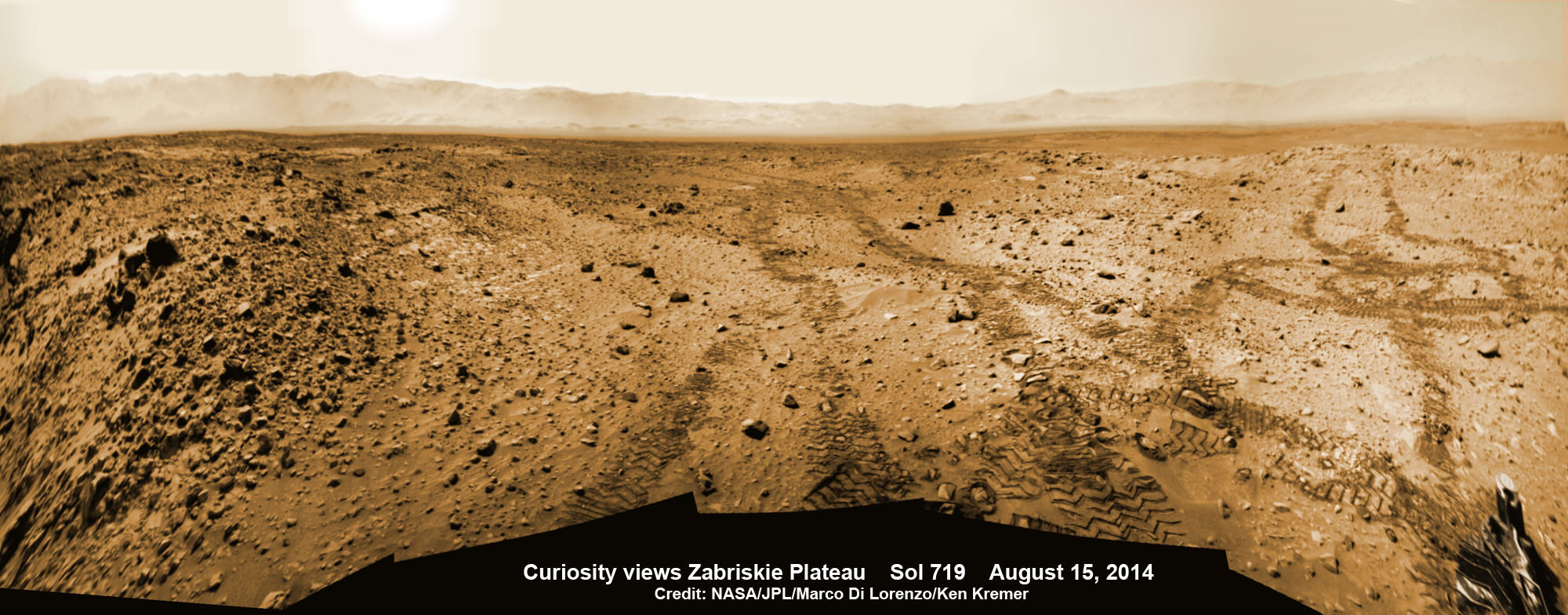
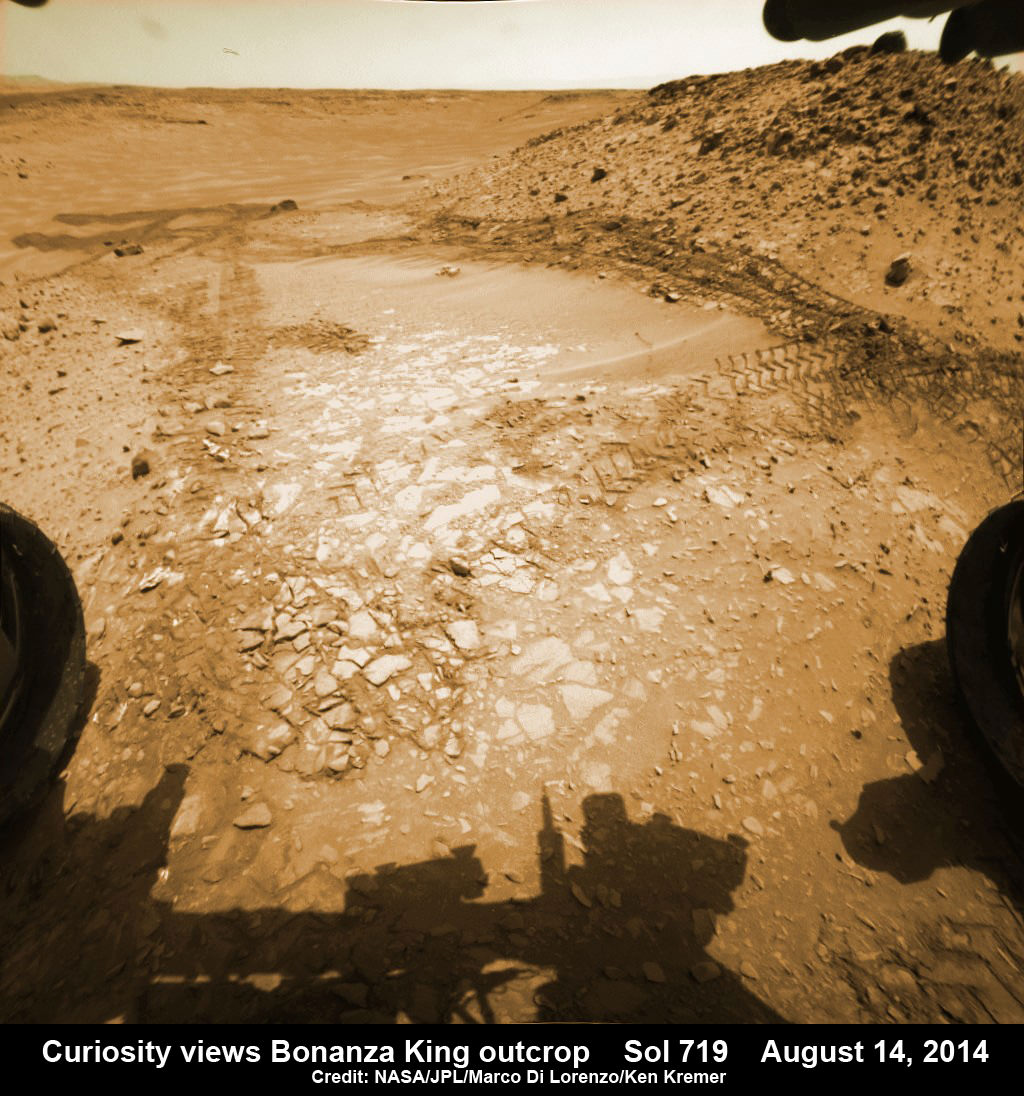
It will take a route skirting the north side of the sandy-floored valley taking care to steer away from the pointiest rocks. Curiosity rover looks back to the rocky plains of the Zabriskie plateau from sandy ramp into ‘Hidden Valley’ with 4th drill site target at ‘Bonanza King’ rock outcrop as shown in this photo mosaic view captured on Aug. 14, 2014, Sol 719. Sharp edged rocks at Zabriskie tore new holes into rover wheels. Navcam camera raw images stitched and colorized. Credit: NASA/JPL-Caltech/Marco Di Lorenzo/Ken Kremer-kenkremer.com
“After further analysis of the sand, Hidden Valley does not appear to be navigable with the desired degree of confidence,” Erickson said. “We will use a route avoiding the worst of the sharp rocks as we drive slightly to the north of Hidden Valley.”
To date, Curiosity’s odometer totals over 5.5 miles (9.0 kilometers) since landing inside Gale Crater on Mars in August 2012. She has taken over 179,000 images.
Curiosity still has about another 2 miles (3 kilometers) to go to reach the entry way at a gap in the treacherous sand dunes at the foothills of Mount Sharp sometime later this year.
Hidden Valley gives a foretaste of the rippely slippery sand dune challenges lurking ahead!
Mount Sharp is a layered mountain that dominates most of Gale Crater and towers 3.4 miles (5.5 kilometers) into the Martian sky and is taller than Mount Rainier.
“Getting to Mount Sharp is the next big step for Curiosity and we expect that in the Fall of this year,” Dr. Jim Green, NASA’s Director of Planetary Sciences at NASA Headquarters, Washington, DC, told me in an interview marking the 2nd anniversary since touchdown on Aug. 6.
“Drilling on the crater floor will provide needed geologic context before Curiosity climbs the mountain.”
The team may go back to its original plan to drill at the potential science destination known as “Pahrump Hills” which was changed due to the route change forced by the slippery sands in Hidden Valley.
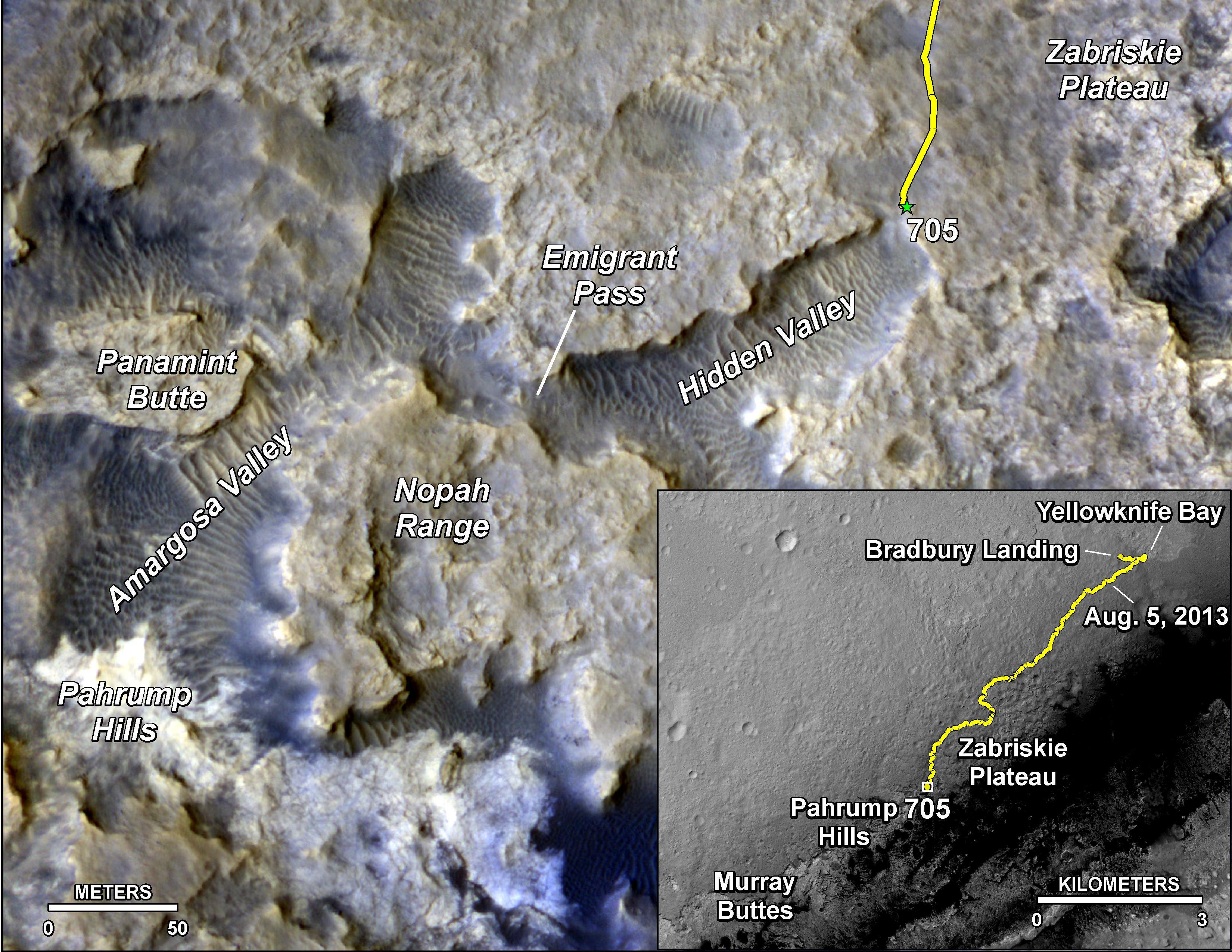
The main map here shows the assortment of landforms near the location of NASA’s Curiosity Mars rover as the rover’s second anniversary of landing on Mars nears. The gold traverse line entering from upper right ends at Curiosity’s position as of Sol 705 on Mars (July 31, 2014). The inset map shows the mission’s entire traverse from the landing on Aug. 5, 2012, PDT (Aug. 6, EDT) to Sol 705, and the remaining distance to long-term science destinations near Murray Buttes, at the base of Mount Sharp. The label “Aug. 5, 2013” indicates where Curiosity was one year after landing. Credit: NASA/JPL-Caltech/Univ. of Arizona
Read an Italian language version of this story by my imaging partner Marco Di Lorenzo – here
Stay tuned here for Ken’s continuing Rosetta, Curiosity, Opportunity, Orion, SpaceX, Boeing, Orbital Sciences, Dream Chaser, commercial space, MAVEN, MOM, Mars and more planetary and human spaceflight news.
Curiosity rover panorama of Mount Sharp captured on June 6, 2014 (Sol 651) during traverse inside Gale Crater. Note rover wheel tracks at left. She will eventually ascend the mountain at the ‘Murray Buttes’ at right later this year. Assembled from Mastcam color camera raw images and stitched by Marco Di Lorenzo and Ken Kremer. Credit: NASA/JPL/MSSS/Marco Di Lorenzo/Ken Kremer-kenkremer.com Up close view of hole in one of rover Curiosity’s six wheels caused by recent driving over rough Martian rocks. Mosaic assembled from Mastcam raw images taken on Dec. 22, 2013 (Sol 490). Credit: NASA/JPL/MSSS/Ken Kremer – kenkremer.com/Marco Di Lorenzo
NASA’s Curiosity rover looks back to ramp with potential 4th drill site target at ‘Bonanza King’ rock outcrop in ‘Hidden Valley’ in this photo mosaic view captured on Aug. 6, 2014, Sol 711. Inset shows results of brushing on Aug. 17, Sol 722, that revealed gray patch beneath red dust. Note the rover’s partial selfie, valley walls, deep wheel tracks in the sand dunes and distant rim of Gale crater beyond the ramp. Navcam camera raw images stitched and colorized. Credit: NASA/JPL-Caltech/Ken Kremer-kenkremer.com/Marco Di Lorenzo
Curiosity brushes ‘Bonanza King’ drill target on Mars
NASA’s Curiosity rover looks back to ramp with 4th drill site target at ‘Bonanza King’ rock outcrop in ‘Hidden Valley’ in this photo mosaic view captured on Aug. 6, 2014, Sol 711. Inset shows results of brushing on Aug. 17, Sol 722, that revealed gray patch beneath red dust. Note the rover’s partial selfie, valley walls, deep wheel tracks in the sand dunes and distant rim of Gale crater beyond the ramp. Navcam camera raw images stitched and colorized.
Credit: NASA/JPL-Caltech/Ken Kremer-kenkremer.com/Marco Di Lorenzo[/caption]
Eagerly eyeing her next drill site on Mars, NASA’s Curiosity rover laid the groundwork by brushing the chosen rock target called ‘Bonanza King’ on Wednesday, Aug. 17, Sol 722, with the Dust Removal Tool (DRT) and collecting high resolution imagery with the Mast Camera (Mastcam) to confirm the success of the operation.
By brushing aside the reddish, more-oxidized dust scientists and engineers leading the mission observed a gray patch of less-oxidized rock material beneath that they anticipated seeing while evaluating the utility of ‘Bonanza King’ as the rover’s fourth candidate for Red Planet rock drilling and sampling.
To date, the 1-ton robot has drilled into three target rocks to collect sample powder for analysis by the rover’s onboard pair of the chemistry labs, SAM and CheMin, to analyze for the chemical ingredients that could support Martian microbes, if they ever existed.
Curiosity rover used the Dust Removal Tool on its robotic arm to brush aside reddish, more-oxidized dust, revealing a gray patch of less-oxidized rock material at a target called “Bonanza King,” visible in this image from the rover’s Mast Camera (Mastcam). Credit: NASA/JPL-Caltech/MSSS
So far everything is proceeding quite well.
The brushing activity also revealed thin, white, cross-cutting veins which is a further indication that liquid water flowed here in the distant past. Water is a prerequisite for life as we know it.
“They might be sulfate salts or another type of mineral that precipitated out of solution and filled fractures in the rock. These thin veins might be related to wider light-toned veins and features in the surrounding rock,” NASA said in a statement.
Based on these results and more from laser zapping with Curiosity’s Chemistry and Camera (ChemCam) instrument on Sol 719 (Aug. 14, 2014) the team decided to proceed ahead.
The imminent next step is to bore a shallow test hole into the brushed area which measures about about 2.5 inches (6 centimeters) across.
If all goes well with the “mini-drill” operation, the team will proceed quickly with full depth drilling to core a sample from the interior of the dinner plate sized rock slab for delivery to Curiosity’s two chemistry labs.
Bonanza King sits in a bright outcrop on the low ramp at the northeastern end of a spot leading in and out of an area called “Hidden Valley” which lies between Curiosity’s August 2012 landing site in Gale Crater and her ultimate destinations on Mount Sharp which dominates the center of the crater.
Just days ago, the rover team commanded a quick exit from “Hidden Valley” to backtrack out of the dune filled valley because of fears the six wheeled robot could get stuck in slippery sands extending the length of a football field.
As Curiosity drills, the rover team is also searching for an alternate safe path forward to the sedimentary layers of Mount Sharp.
To date, Curiosity’s odometer totals over 5.5 miles (9.0 kilometers) since landing inside Gale Crater on Mars in August 2012. She has taken over 178,000 images.
The main map here shows the assortment of landforms near the location of NASA’s Curiosity Mars rover as the rover’s second anniversary of landing on Mars nears. The gold traverse line entering from upper right ends at Curiosity’s position as of Sol 705 on Mars (July 31, 2014). The inset map shows the mission’s entire traverse from the landing on Aug. 5, 2012, PDT (Aug. 6, EDT) to Sol 705, and the remaining distance to long-term science destinations near Murray Buttes, at the base of Mount Sharp. The label “Aug. 5, 2013” indicates where Curiosity was one year after landing. Credit: NASA/JPL-Caltech/Univ. of Arizona
Curiosity still has about another 2 miles (3 kilometers) to go to reach the entry way at a gap in the treacherous sand dunes at the foothills of Mount Sharp sometime later this year.
Mount Sharp is a layered mountain that dominates most of Gale Crater and towers 3.4 miles (5.5 kilometers) into the Martian sky and is taller than Mount Rainier.
“Getting to Mount Sharp is the next big step for Curiosity and we expect that in the Fall of this year,” Dr. Jim Green, NASA’s Director of Planetary Sciences at NASA Headquarters, Washington, DC, told me in an interview making the 2nd anniversary on Aug. 6.
“Drilling on the crater floor will provide needed geologic context before Curiosity climbs the mountain.”
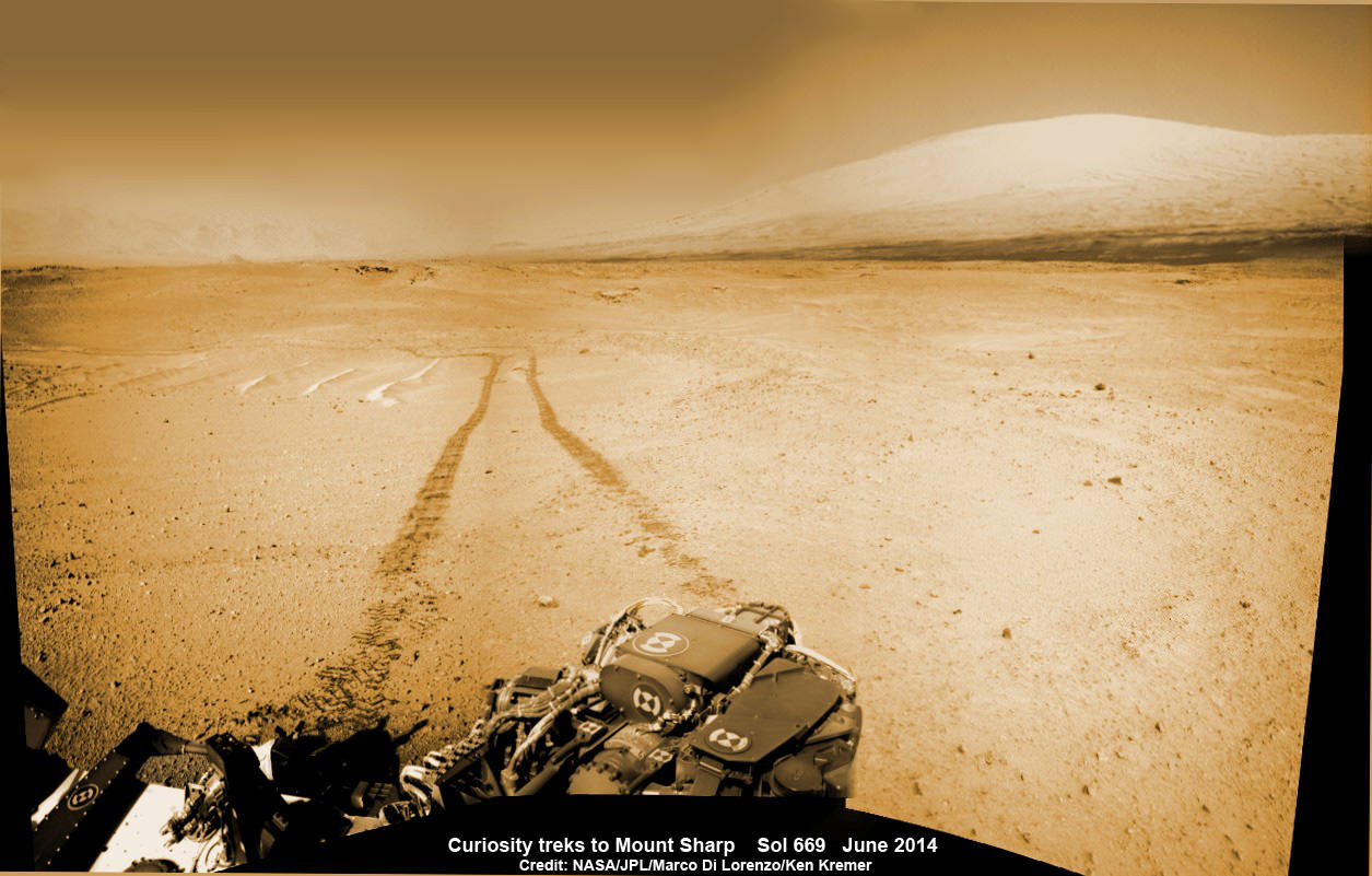
1 Martian Year on Mars! Curiosity treks to Mount Sharp in this photo mosaic view captured on Sol 669, June 24, 2014. Navcam camera raw images stitched and colorized. Credit: NASA/JPL-Caltech/Marco Di Lorenzo/Ken Kremer – kenkremer.com
Read an Italian language version of this story by my imaging partner Marco Di Lorenzo – here
Stay tuned here for Ken’s continuing Rosetta, Curiosity, Opportunity, Orion, SpaceX, Boeing, Orbital Sciences, Dream Chaser, commercial space, MAVEN, MOM, Mars and more planetary and human spaceflight news.
NASA’s Curiosity rover looks back to ramp with 4th drill site target at ‘Bonanza King’ rock outcrop in ‘Hidden Valley’ at site marking her 2nd anniversary on Mars, as shown in this photo mosaic view captured on Aug. 6, 2014, Sol 711. Note the rover’s partial selfie, valley walls, deep wheel tracks in the sand dunes and distant rim of Gale crater beyond the ramp. Navcam camera raw images stitched and colorized. Credit: NASA/JPL-Caltech/Ken Kremer-kenkremer.com/Marco Di Lorenzo
NASA’s Curiosity rover looks back to ramp with 4th drill site target at ‘Bonanza King’ rock outcrop in ‘Hidden Valley’ at site marking her 2nd anniversary on Mars, as shown in this photo mosaic view captured on Aug. 6, 2014, Sol 711. Note the rover’s partial selfie, valley walls, deep wheel tracks in the sand dunes and distant rim of Gale crater beyond the ramp. Navcam camera raw images stitched and colorized.
Credit: NASA/JPL-Caltech/Ken Kremer-kenkremer.com/Marco Di Lorenzo[/caption]
Not wanting to get stuck in a rut, Curiosity’s handlers have commanded NASA’s SUV-sized rover to reverse course and drive out of a potentially hazardous Martian valley of slippery sand with poor wheel traction and instead backtrack towards an enticing nearby spot that the team feels could be the fourth candidate for rock drilling – and thereby widen the scope of the story of habitable environments on the Red Planet.
The new drilling target under up close evaluation right now is named ‘Bonanza King’ – shown in our photo mosaic above.
Bonanza King was chosen after the six wheeled rover unexpectedly experienced significant wheel slippage in the past week while driving over an extended dune field of sandy ripples that basically stopped forward movement inside the Martian valley.
The team was thus in a quandary over whether to push forward on a route through the loose sands of “Hidden Valley” and possibly risk getting mired in a hidden sand trap or drive backwards over a field of sharp rocks on the “Zabriskie plateau” and beyond that are certain to tear further holes in the wheels.
Drilling Candidate Site ‘Bonanza King’ on Mars. This image from the Mast Camera (Mastcam) on NASA’s Curiosity Mars rover shows a portion of the pale rock outcrop that includes the “Bonanza King” target chosen for evaluation as the mission’s fourth rock-drilling site. Raised ridges on the flat rocks — possible mineral veins — are visible at upper and middle right. Tread marks from one of Curiosity’s wheels are visible in the lower half of the image from Sol 707, Aug. 12, 2014. Credit: NASA/JPL-Caltech/MSSS
As reported here last week on the occasion of her 2nd anniversary on Mars since the dramatic touchdown inside Gale Crater on Aug. 6, 2012, Curiosity had been driving merrily through the supposed safe valley of sandy ripples of “Hidden Valley.” She was approaching a bedrock unit named “Pahrump Hills” that for the first time is actually part of the humongous mountain named Mount Sharp she will soon scale and which is the primary science destination of the mission.
But rather soon after driving over a low hump from Zabriskie plateau (see our mosaic below) into Hidden Valley, the robot experienced wheel slippage in the ripples of sand filling the crater floor which was much higher than anticipated. And even worse than comparable test drives in a practice sand lot at JPL.
Curiosity rover looks back to the rocky plains of the Zabriskie plateau from sandy ramp into ‘Hidden Valley’ with 4th drill site target at ‘Bonanza King’ rock outcrop as shown in this photo mosaic view captured on Aug. 14, 2014, Sol 719. Sharp edged rocks at Zabriskie tore new holes into rover wheels. Navcam camera raw images stitched and colorized.
Credit: NASA/JPL-Caltech/Marco Di Lorenzo/Ken Kremer-kenkremer.com
The sandy ripples extend out to the sloping valley walls with no end in sight.
“We need to gain a better understanding of the interaction between the wheels and Martian sand ripples, and Hidden Valley is not a good location for experimenting,” said Curiosity Project Manager Jim Erickson of NASA’s Jet Propulsion Laboratory in Pasadena, California, in a statement.
And since Hidden Valley is as long as a football field and has only two navigable exits at the northeastern and southwestern ends (see map below), the team was forced to drive back to the entrance way at the northern end to consider an alternative route forward to the base of Mount Sharp.
In the meantime while they evaluate the way forward, the team decided that Bonanza King offers similar science to what scientists anticipate at the outcrops at “Pahrump Hills”- a preview of a geological unit that is part of the base of Mount Sharp for the first time since landing rather than still belonging to the floor of Gale Crater.
“Geologically speaking, we can tie the Bonanza King rocks to those at Pahrump Hills. Studying them here will give us a head start in understanding how they fit into the bigger picture of Gale Crater and Mount Sharp,” said Curiosity Deputy Project Scientist Ashwin Vasavada of JPL, in a statement.
Bonanza King sits in an bright outcrop on the low ramp leading in and out of Hidden Valley.
Curiosity rover up close view of ‘Bonanza King’ rock outcrop and 4th drill target looking down from ramp and back into ‘Hidden Valley’ and hazardous dune field of sandy ripples on Aug. 14, 2014, Sol 719. Wheel tracks show where Curiosity drove into the valley, and back out again, earlier in August 2014. The largest of the individual flat rocks in the foreground are a few inches (several centimeters) across. Hazcam camera raw image flattened and colorized. Credit: NASA/JPL-Caltech/Marco Di Lorenzo/Ken Kremer – kenkremer.com
It looks like a pale paving stone. Since its location within the geological layers visible on the ramp is similar to what was expected at the Pahrump Hills outcrop, it’s very appealing to the science team.
Furthermore when one of the rovers wheel’s drove over the outcrop, it cracked open one of the rocks and exposed bright interior material, possibly from mineral veins – which is super exciting from a science perspective as a potential marker for flowing liquid water.
Right now the team is collecting spectral data with the science instruments to assess its science utility and is planning a super fast drilling campaign, far shorter than the prior three.
The plan would be to core a sample from the interior of the dinner plate sized rock slab for delivery to Curiosity’s pair of the onboard chemistry labs, SAM and CheMin to analyze for the chemical ingredients to support miartin microbes, if they ever existed.
“This outcrop on the ramp is too appealing to pass up,” Vasavada said.
The main map here shows the assortment of landforms near the location of NASA’s Curiosity Mars rover as the rover’s second anniversary of landing on Mars nears. The gold traverse line entering from upper right ends at Curiosity’s position as of Sol 705 on Mars (July 31, 2014). The inset map shows the mission’s entire traverse from the landing on Aug. 5, 2012, PDT (Aug. 6, EDT) to Sol 705, and the remaining distance to long-term science destinations near Murray Buttes, at the base of Mount Sharp. The label “Aug. 5, 2013” indicates where Curiosity was one year after landing. Credit: NASA/JPL-Caltech/Univ. of Arizona
To date, Curiosity’s odometer totals over 5.5 miles (9.0 kilometers) since landing inside Gale Crater on Mars in August 2012. She has taken over 178,000 images.
Curiosity still has about another 2 miles (3 kilometers) to go to reach the entry way at a gap in the treacherous sand dunes at the foothills of Mount Sharp sometime later this year.
Mount Sharp is a layered mountain that dominates most of Gale Crater and towers 3.4 miles (5.5 kilometers) into the Martian sky and is taller than Mount Rainier.
“Getting to Mount Sharp is the next big step for Curiosity and we expect that in the Fall of this year,” Dr. Jim Green, NASA’s Director of Planetary Sciences at NASA Headquarters, Washington, DC, told me in an interview making the 2nd anniversary on Aug. 6.
Up close view of hole in one of rover Curiosity’s six wheels caused by driving over rough Martian rocks. Mosaic assembled from Mastcam raw images taken on Dec. 22, 2013 (Sol 490). Credit: NASA/JPL/MSSS/Ken Kremer – kenkremer.com/Marco Di Lorenzo
Stay tuned here for Ken’s continuing Rosetta, Curiosity, Opportunity, Orion, SpaceX, Boeing, Orbital Sciences, Dream Chaser, commercial space, MAVEN, MOM, Mars and more planetary and human spaceflight news.
1 Martian Year on Mars!
Curiosity treks to Mount Sharp in this photo mosaic view captured on Sol 669, June 24, 2014. Navcam camera raw images stitched and colorized. Credit: NASA/JPL-Caltech/Marco Di Lorenzo/Ken Kremer – kenkremer.com2 Earth Years on Mars! NASA’s Curiosity rover celebrated the 2nd anniversary on Mars at ‘Hidden Valley’ as shown in this photo mosaic view captured on Aug. 6, 2014, Sol 711. Note the valley walls, rover tracks and distant crater rim. Navcam camera raw images stitched and colorized. Credit: NASA/JPL-Caltech/Ken Kremer-kenkremer.com/Marco Di Lorenzo
1 Martian Year on Mars! Curiosity treks to Mount Sharp in this photo mosaic view captured on Sol 669, June 24, 2014. Navcam camera raw images stitched and colorized. Credit: NASA/JPL-Caltech/Marco Di Lorenzo/Ken Kremer – kenkremer.com
2 Years on Mars!
Curiosity treks to Mount Sharp, her primary science destination, in this photo mosaic view captured on Sol 669, June 24, 2014. Navcam camera raw images stitched and colorized. Credit: NASA/JPL-Caltech/Marco Di Lorenzo/Ken Kremer – kenkremer.com
Story and mosaics updated[/caption]
NASA’s most scientifically powerful rover ever dispatched to the Red Planet, Curiosity, is celebrating her 2nd anniversary on Mars since the dramatic touchdown inside Gale Crater on Aug. 6, 2012, EDT (Aug. 5, 2012, PDT) while simultaneously approaching a bedrock unit that for the first time is actually part of the humongous mountain she will soon scale and is the primary science destination of the mission.
Mount Sharp is a layered mountain that dominates most of Gale Crater and towers 3.4 miles (5.5 kilometers) into the Martian sky and is taller than Mount Rainier.
Aug. 6, 2014 marks ‘2 Years on Mars’ and Sol 711 for Curiosity in an area called “Hidden Valley.”
“Getting to Mount Sharp is the next big step for Curiosity and we expect that in the Fall of this year,” Dr. Jim Green, NASA’s Director of Planetary Sciences at NASA Headquarters, Washington, DC, told me in an interview making the 2nd anniversary.
The 1 ton rover is equipped with 10 state-of-the-art science instruments and searching for signs of life.
The mysterious mountain is so huge that outcrops of bedrock extend several miles out from its base and Curiosity is now within striking distance of reaching the area the rover team calls “Pahrump Hills.”
2 Earth Years on Mars!
NASA’s Curiosity rover celebrated the 2nd anniversary on Mars at ‘Hidden Valley’ as shown in this photo mosaic view captured on Aug. 6, 2014, Sol 711. Note the valley walls, rover tracks and distant crater rim. Navcam camera raw images stitched and colorized. Credit: NASA/JPL-Caltech/Ken Kremer-kenkremer.com/Marco Di Lorenzo
Scientists anticipate that the outcrops at “Pahrump Hills” offer a preview of a geological unit that is part of the base of Mount Sharp for the first time since landing rather than still belonging to the floor of Gale Crater.
“We’re coming to our first taste of a geological unit that’s part of the base of the mountain rather than the floor of the crater,” said Curiosity Project Scientist John Grotzinger of the California Institute of Technology, Pasadena, in a statement.
“We will cross a major terrain boundary.”
Since “Pahrump Hills” is less than one-third of a mile (500 meters) from Curiosity she should arrive soon.
In late July 2014, the rover arrived in an area of sandy terrain called “Hidden Valley” which is on the planned route ahead leading to “Pahrump Hills” and easily traversable with few of the sharp edged rocks that have caused significant damage to the rovers six aluminum wheels.
This full-circle panorama of the landscape surrounding NASA’s Curiosity Mars rover on July 31, 2014, Sol 705, offers a view into sandy lower terrain called “Hidden Valley,” which is on the planned route ahead. It combines several images from Curiosity’s Navigation Camera. South is at the center. Credit: NASA/JPL-Caltech
The sedimentary layers in the lower slopes of Mount Sharp have been Curiosity’s long-term science destination.
They are the principal reason why the science team specifically chose Gale Crater as the primary landing site based on high resolution spectral observations collected by NASA’s powerful Mars Reconnaissance Orbiter (MRO) indicating the presence of deposits of clay-bearing sedimentary rocks.
Curiosity’s goal all along has been to determine whether Mars ever offered environmental conditions favorable for microbial life. Finding clay bearing minerals. or phyllosilicates, in Martian rocks is the key to fulfilling its major objective.
The team expected to find the clay bearing minerals only in the sedimentary layers at the lower reaches of Mount Sharp.
Curiosity rover panorama of Mount Sharp captured on June 6, 2014 (Sol 651) during traverse inside Gale Crater. Note rover wheel tracks at left. She will eventually ascend the mountain at the ‘Murray Buttes’ at right later this year. Assembled from Mastcam color camera raw images and stitched by Marco Di Lorenzo and Ken Kremer. Credit: NASA/JPL/MSSS/Marco Di Lorenzo/Ken Kremer-kenkremer.com
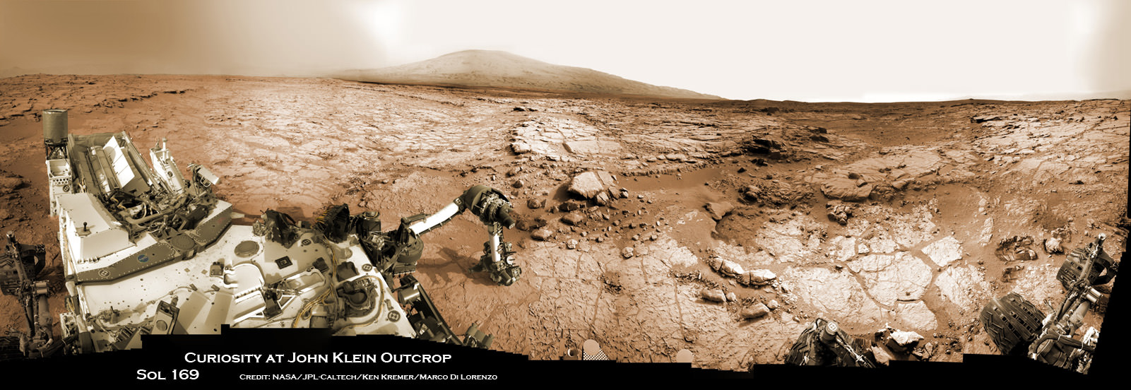
Soon after landing, the team spotted some rather interesting looking outcrops barely a half mile away from the touchdown zone at a spot dubbed ‘Yellowknife Bay” and decided to take a detour towards it to investigate.
Well the scientists won the bet and struck scientific gold barely six months after landing when they drilled into a rock outcrop named “John Klein” at “Yellowknife Bay” and unexpectedly discovered the clay bearing minerals on the crater floor.
Yellowknife Bay was found to be an ancient lakebed where liquid water flowed on Mars surface billions of years ago.
The discovery of phyllosilicates in the 1st drill sample during the spring of 2013 meant that Curiosity had rather remarkably already fulfilled its primary goal of finding a habitable zone during its first year of operations!
The rock analysis “yielded evidence of a lakebed environment billions of years ago that offered fresh water, all of the key elemental ingredients for life, and a chemical source of energy for microbes, if any existed there,” according to NASA.
Curiosity accomplished Historic 1st drilling into Martian rock at John Klein outcrop on Feb 8, 2013 (Sol 182) and discovered a habitable zone, shown in this context mosaic view of the Yellowknife Bay basin taken on Jan. 26 (Sol 169). The robotic arm is pressing down on the surface at John Klein outcrop of veined hydrated minerals – dramatically back dropped with her ultimate destination; Mount Sharp. Credit: NASA/JPL-Caltech/Ken Kremer-kenkremer.com/Marco Di Lorenzo
“Before landing, we expected that we would need to drive much farther before answering that habitability question,” said Curiosity Project Scientist John Grotzinger of the California Institute of Technology, Pasadena. “We were able to take advantage of landing very close to an ancient streambed and lake. Now we want to learn more about how environmental conditions on Mars evolved, and we know where to go to do that.”
During the rovers second Earth year on the Red Planet, Curiosity has been driving as fast as possible towards a safe entry point to the slopes of Mount Sharp. The desired destination for the car sized rover is now about 2 miles (3 kilometers) southwest of its current location.
‘Driving, Driving, Driving’ is indeed the rover teams mantra.
The main map here shows the assortment of landforms near the location of NASA’s Curiosity Mars rover as the rover’s second anniversary of landing on Mars nears. The gold traverse line entering from upper right ends at Curiosity’s position as of Sol 705 on Mars (July 31, 2014). The inset map shows the mission’s entire traverse from the landing on Aug. 5, 2012, PDT (Aug. 6, EDT) to Sol 705, and the remaining distance to long-term science destinations near Murray Buttes, at the base of Mount Sharp. The label “Aug. 5, 2013” indicates where Curiosity was one year after landing. Credit: NASA/JPL-Caltech/Univ. of Arizona
To date, Curiosity’s odometer totals over 5.5 miles (9.0 kilometers) since landing inside Gale Crater on Mars in August 2012. She has taken over 174,000 images.
Curiosity still has about another 2 miles (3 kilometers) to go to reach the entry way at a gap in the treacherous sand dunes at the foothills of Mount Sharp sometime later this year.
And NASA is moving forward with future Red Planet missions when it recently announced the selection of 7 instruments chosen to fly aboard the Mars 2020 rover, the agency’s next rover going to Mars that will search for signs of ancient life as well as carry a technology demonstration that will help pave the way for ‘Humans to Mars’ in the 2030s. Read my story – here.
Coincidentally, ESA’s Rosetta comet hunting spacecraft arrived in orbit at its destination Comet 67P after a 10 year voyage on the same day as Curiosity’s 2 Earth year anniversary.
Stay tuned here for Ken’s continuing Rosetta, Curiosity, Opportunity, Orion, SpaceX, Boeing, Orbital Sciences, commercial space, MAVEN, MOM, Mars and more planetary and human spaceflight news.
Up close view of hole in one of rover Curiosity’s six wheels caused by recent driving over rough Martian rocks. Mosaic assembled from Mastcam raw images taken on Dec. 22, 2013 (Sol 490). Credit: NASA/JPL/MSSS/Ken Kremer – kenkremer.com/Marco Di Lorenzo
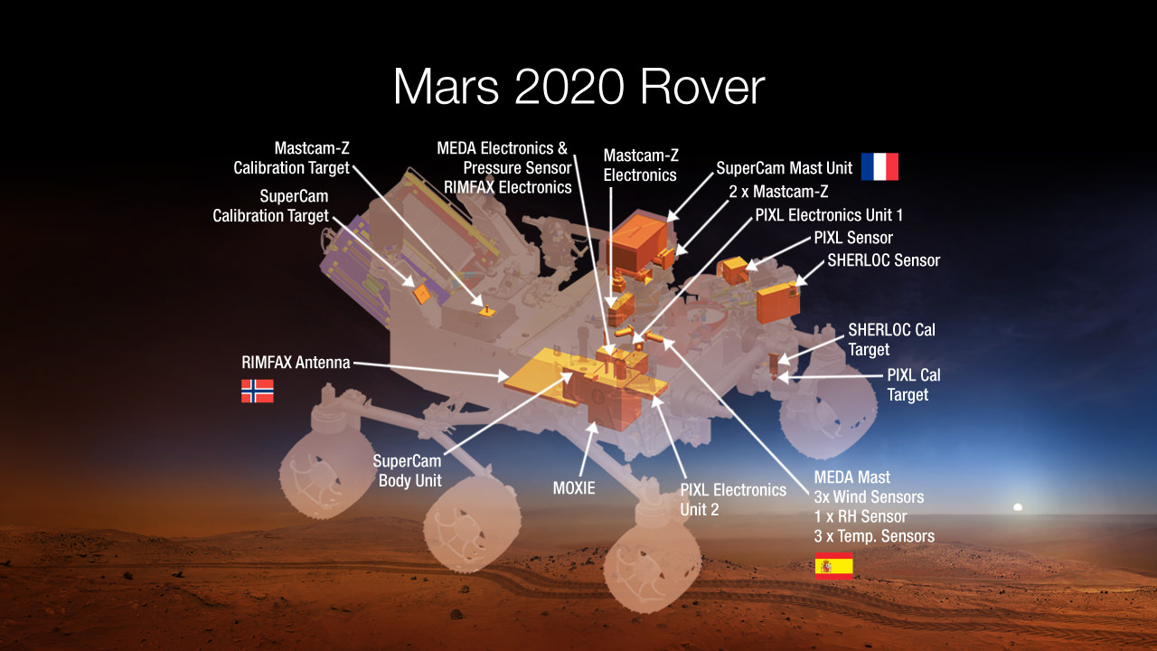
An artist concept image of where seven carefully-selected instruments will be located on NASA’s Mars 2020 rover. The instruments will conduct unprecedented science and exploration technology investigations on the Red Planet as never before. Image Credit: NASA
NASA announced the winners of the high stakes science instrument competition to fly aboard the Mars 2020 rover at a briefing held today, Thursday, July 31, at the agency’s headquarters in Washington, D.C.
The 2020 rover’s instruments goals are to search for signs of organic molecules and past life and help pave the way for future human explorers.
Seven carefully-selected payloads were chosen from a total of 58 proposals received in January 2014 from science teams worldwide, which is twice the usual number for instrument competitions and demonstrates the extraordinary interest in Mars by the science community.
The 2020 rover architecture is based on NASA’s hugely successful Mars Science Laboratory (MSL) Curiosity rover which safely touched down a one ton mass on Mars on Aug. 5, 2012 using the nail-biting and never before used skycrane rocket assisted descent system.
The seven instruments will conduct unprecedented science and technology investigations on the Red Planet that’s aimed for the first time at simultaneously advancing both NASA’s unmanned robotic exploration searching for extraterrestrial life and plans for human missions to Mars in the 2030’s.
Planning for NASA’s 2020 Mars rover envisions a basic structure that capitalizes on the design and engineering work done for the NASA rover Curiosity, which landed on Mars in 2012, but with new science instruments selected through competition for accomplishing different science objectives. Image Credit: NASA/JPL-Caltech
The instruments will have the capability to detect low levels of organic molecules that are essential precursors to life.
A technology demonstration experiment will use Mars natural resources to generate oxygen from atmospheric carbon dioxide that can be used as rocket fuel or for human explorers. This will save enormous costs by enabling astronauts to ‘live off the land’ rather than having to bring everything needed for survival from Earth.
NASA said that the development cost for the chosen instruments is approximately $130 million out of a total cost of $1.9 Billion.
This overall cost is less than Curiosity’s approximate $2.4 Billion cost since the team is rebuilding the rover and landing architecture – sort of an MSL 2 so to speak – developed for Curiosity and also using several left over MSL flight spares.
Mars 2020 builds on the architecture developed for Curiosity.
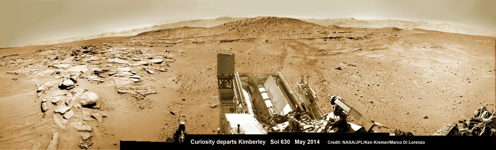
Curiosity’s panoramic view departing Mount Remarkable and ‘The Kimberley Waypoint’ where rover conducted 3rd drilling campaign inside Gale Crater on Mars. The navcam raw images were taken on Sol 630, May 15, 2014, stitched and colorized. Credit: NASA/JPL-Caltech/Ken Kremer – kenkremer.com/Marco Di Lorenzo
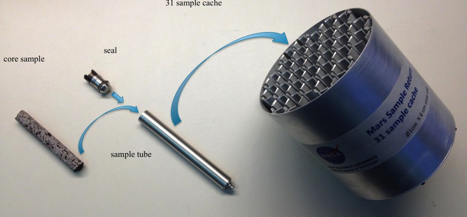
The Mars 2020 rover will also have a sample cacher with the ability to store core samples collected by the rover’s drill for later retrieval and return to Earth at an as yet unspecified time.
“The Mars 2020 rover, with these new advanced scientific instruments, including those from our international partners, holds the promise to unlock more mysteries of Mars’ past as revealed in the geological record,” said John Grunsfeld, astronaut and associate administrator of NASA’s Science Mission Directorate in Washington.
“This mission will further our search for life in the universe and also offer opportunities to advance new capabilities in exploration technology.”
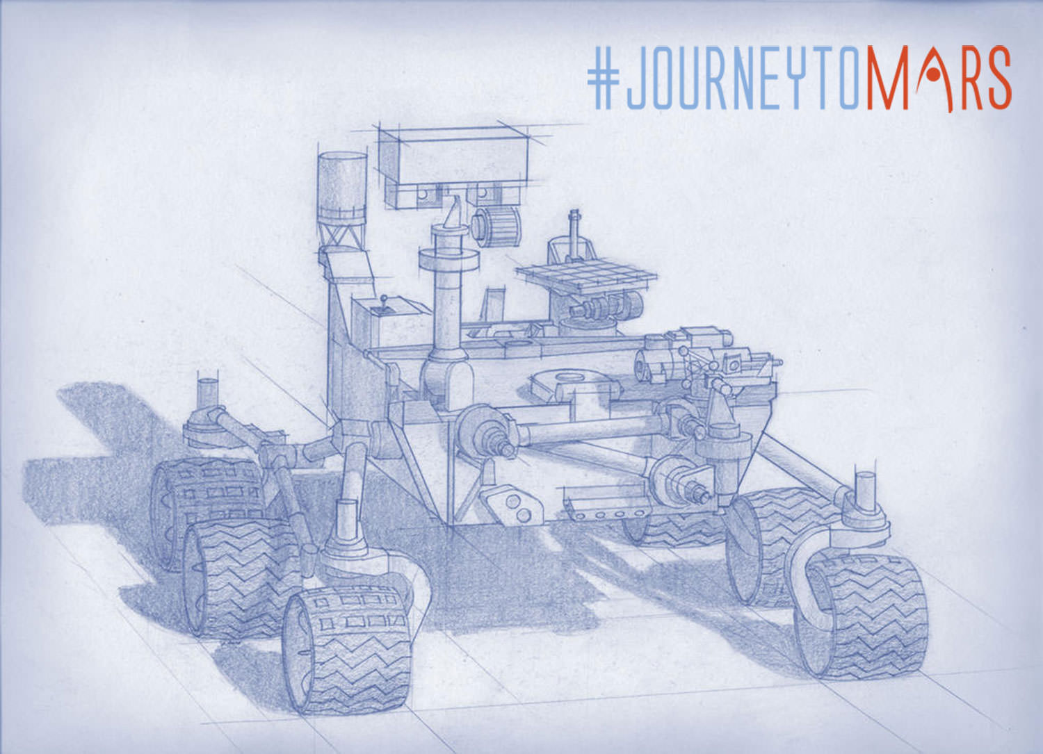
NASA’s Mars 2020 rover will explore the Red Planet like never before. Credit: NASAHere’s a list of the 7 selected science payload proposals. They are in some ways more advanced versions form Curiosity and in other ways completely new:
Mastcam-Z, an advanced camera system with panoramic and stereoscopic imaging capability with the ability to zoom. The instrument also will determine mineralogy of the Martian surface and assist with rover operations. The principal investigator is James Bell, Arizona State University in Phoenix.
SuperCam, an instrument that can provide imaging, chemical composition analysis, and mineralogy. The instrument will also be able to detect the presence of organic compounds in rocks and regolith from a distance. The principal investigator is Roger Wiens, Los Alamos National Laboratory, Los Alamos, New Mexico. This instrument also has a significant contribution from the Centre National d’Etudes Spatiales,Institut de Recherche en Astrophysique et Planetologie (CNES/IRAP) France.
Planetary Instrument for X-ray Lithochemistry (PIXL), an X-ray fluorescence spectrometer that will also contain an imager with high resolution to determine the fine scale elemental composition of Martian surface materials. PIXL will provide capabilities that permit more detailed detection and analysis of chemical elements than ever before. The principal investigator is Abigail Allwood, NASA’s Jet Propulsion Laboratory (JPL) in Pasadena, California.
Scanning Habitable Environments with Raman & Luminescence for Organics and Chemicals (SHERLOC), a spectrometer that will provide fine-scale imaging and uses an ultraviolet (UV) laser to determine fine-scale mineralogy and detect organic compounds. SHERLOC will be the first UV Raman spectrometer to fly to the surface of Mars and will provide complementary measurements with other instruments in the payload. The principal investigator is Luther Beegle, JPL.
The Mars Oxygen ISRU Experiment (MOXIE), an exploration technology investigation that will produce oxygen from Martian atmospheric carbon dioxide. The principal investigator is Michael Hecht, Massachusetts Institute of Technology, Cambridge, Massachusetts.
Mars Environmental Dynamics Analyzer (MEDA), a set of sensors that will provide measurements of temperature, wind speed and direction, pressure, relative humidity and dust size and shape. The principal investigator is Jose Rodriguez-Manfredi, Centro de Astrobiologia, Instituto Nacional de Tecnica Aeroespacial, Spain.
The Radar Imager for Mars’ Subsurface Exploration (RIMFAX), a ground-penetrating radar that will provide centimeter-scale resolution of the geologic structure of the subsurface. The principal investigator is Svein-Erik Hamran, Forsvarets Forskning Institute, Norway.
So the instruments are more sophisticated, upgraded hardware versions as well as new instruments to conduct geological assessments of the rover’s landing site, determine the potential habitability of the environment, and directly search for signs of ancient Martian life, according to NASA.
Creating a Returnable Cache of Martian Samples is a major objective for NASA’s Mars 2020 rover. This prototype show hardware to cache samples of cores drilled from Martian rocks for possible future return to Earth. The 2020 rover would be to collect and package a carefully selected set of up to 31 samples in a cache that could be returned to Earth by a later mission. The capabilities of laboratories on Earth for detailed examination of cores drilled from Martian rocks would far exceed the capabilities of any set of instruments that could feasibly be flown to Mars. For scale, the diameter of the core sample shown in the image is 0.4 inch (1 centimeter). Credit: NASA/JPL-Caltech
“Today we take another important step on our journey to Mars,” said NASA Administrator Charles Bolden.
“While getting to and landing on Mars is hard, Curiosity was an iconic example of how our robotic scientific explorers are paving the way for humans to pioneer Mars and beyond. Mars exploration will be this generation’s legacy, and the Mars 2020 rover will be another critical step on humans’ journey to the Red Planet.”
Stay tuned here for Ken’s continuing Curiosity, Opportunity, Orion, SpaceX, Boeing, Orbital Sciences, commercial space, MAVEN, MOM, Mars and more Earth and Planetary science and human spaceflight news.
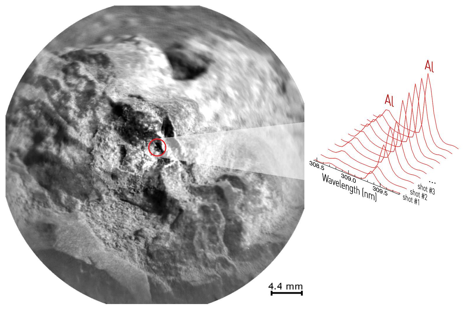
NASA's Curiosity Mars rover used the Mars Hand Lens Imager (MAHLI) camera on its arm to catch the first images of sparks produced by the rover's laser being shot at a rock on Mars. Credit: NASA/JPL-Caltech/MSSS
Curiosity has zapped hundreds of Red Planet rocks with her powerful laser blaster during her lifetime and has now caught the sparks flying for the first time as they happened – as seen in new photos and video above and below released this week by NASA.
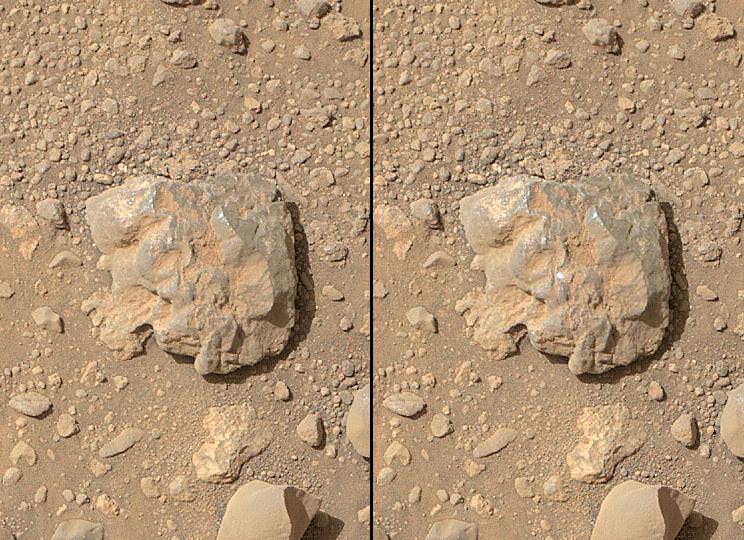
As the NASA rover’s million watt Chemistry and Camera (ChemCam) instrument fired multiple laser shots at a rock fortuitously named “Nova” the team commanded her arm-mounted Mars Hand Lens Imager (MAHLI) high resolution imaging camera to try and capture the action as it occurred, for the first time. And they succeeded.
Curiosity blasted the baseball sized “Nova” rock target over 100 times on July 12, 2014, or Sol 687.
Since the nail biting touchdown nearly two years ago on Aug. 5, 2012 inside Gale Crater, ChemCam has aimed the laser instrument at more than 600 rock or soil targets and fired more than 150,000 laser shots.
Here’s a NASA/JPL video showing the laser flash:
Video Caption: The sparks that appear on the baseball-sized rock (starting at :17) result from the laser of the ChemCam instrument on NASA’s Curiosity Mars rover hitting the rock. Credit: NASA/JPL-Caltech/MSSS
ChemCam is used to determine the composition of Martian rocks and soils at a distance of up to 25 feet (8 meters) yielding preliminary data for the scientists and engineers to decide if a target warrants up close investigation and in rare cases sampling and drilling activities.
ChemCam works through a process called laser-induced breakdown spectroscopy. The laser hits a target with pulses to generate sparks, whose spectra provide information about which chemical elements are in the target.
Successive laser shots are fired in sequence to gradually blast away thin layers of material. Each shot exposes a slightly deeper layer for examination by the ChemCam spectrometer.
As Curiosity fired deeper into “Nova” it showed an increasing concentration of aluminum as the sequential laser blasts penetrated through the uninteresting dust on the rock’s surface. Silicon and sodium were also detected.
“This is so exciting! The ChemCam laser has fired more than 150,000 times on Mars, but this is the first time we see the plasma plume that is created,” said ChemCam Deputy Principal Investigator Sylvestre Maurice, at the Research Institute in Astrophysics and Planetology, of France’s National Center for Scientific Research and the University of Toulouse, France, in a statement.
“Each time the laser hits a target, the plasma light is caught and analyzed by ChemCam’s spectrometers. What the new images add is confirmation that the size and shape of the spark are what we anticipated under Martian conditions.”
A Martian target rock called “Nova,” shown here, displayed an increasing concentration of aluminum as a series of laser shots from NASA’s Curiosity Mars rover penetrated through dust on the rock’s surface. This pattern is typical of many rocks examined with the rover’s laser-firing ChemCam. Credit: NASA/JPL-Caltech/LANL/CNES/IRAP/LPGNantes/CNRS/IAS
The SUZ sized rover is driving as swiftly as possible to the base of Mount Sharp which dominates the center of Gale Crater and reaches 3.4 miles (5.5 km) into the Martian sky – taller than Mount Rainier.
During Year 1 on Mars, Earth’s emissary has already accomplished her primary objective of discovering a habitable zone on the Red Planet that contains the minerals necessary to support microbial life in the ancient past when Mars was far wetter and warmer billions of years ago.
To date, Curiosity’s odometer totals over 5.1 miles (8.4 kilometers) since landing inside Gale Crater on Mars in August 2012. She has taken over 166,000 images.
1 Martian Year on Mars! Curiosity treks to Mount Sharp in this photo mosaic view captured on Sol 669, June 24, 2014. Navcam camera raw images stitched and colorized. Credit: NASA/JPL-Caltech/Marco Di Lorenzo/Ken Kremer – kenkremer.com
Curiosity still has about another 2.4 miles (3.9 kilometers) to go to reach the entry way at a gap in the treacherous sand dunes at the foothills of Mount Sharp sometime later this year.
Stay tuned here for Ken’s continuing Curiosity, Opportunity, Orion, SpaceX, Boeing, Orbital Sciences, commercial space, MAVEN, MOM, Mars and more planetary and human spaceflight news.
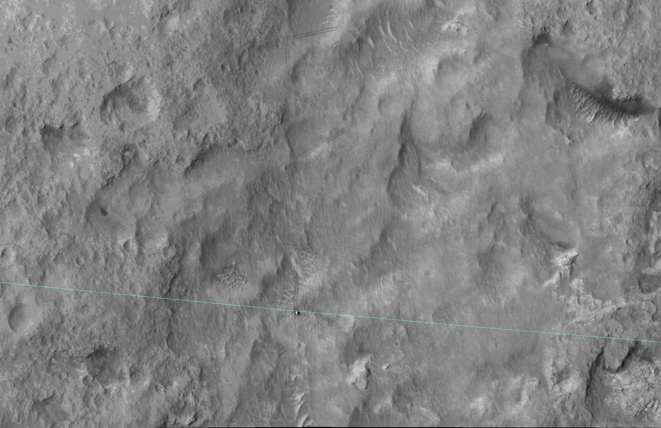
This June 27, 2014, image from the HiRISE camera on NASA's Mars Reconnaissance Orbiter shows NASA's Curiosity Mars rover on the rover's landing-ellipse boundary, which is superimposed on the image. The 12-mile-wide ellipse was mapped as safe terrain for its 2012 landing inside Gale Crater. Image Credit: NASA/JPL-Caltech/Univ. of Arizona
NASA has now released a breathtaking high resolution image of the rover Curiosity captured from Mars orbit coincidentally coinciding with her crossing the targeted landing ellipse just days after she marked ‘1 Martian Year’ on the Red Planet in search of the chemical ingredients necessary to support alien microbial life forms.
The orbital image was taken on June 27 (Sol 672) by the High Resolution Imaging Science Experiment (HiRISE) camera on NASA’s Mars Reconnaissance Orbiter (MRO) and clearly shows the rover and wheel tracks at the end of the drive that Sol, or Martian day.
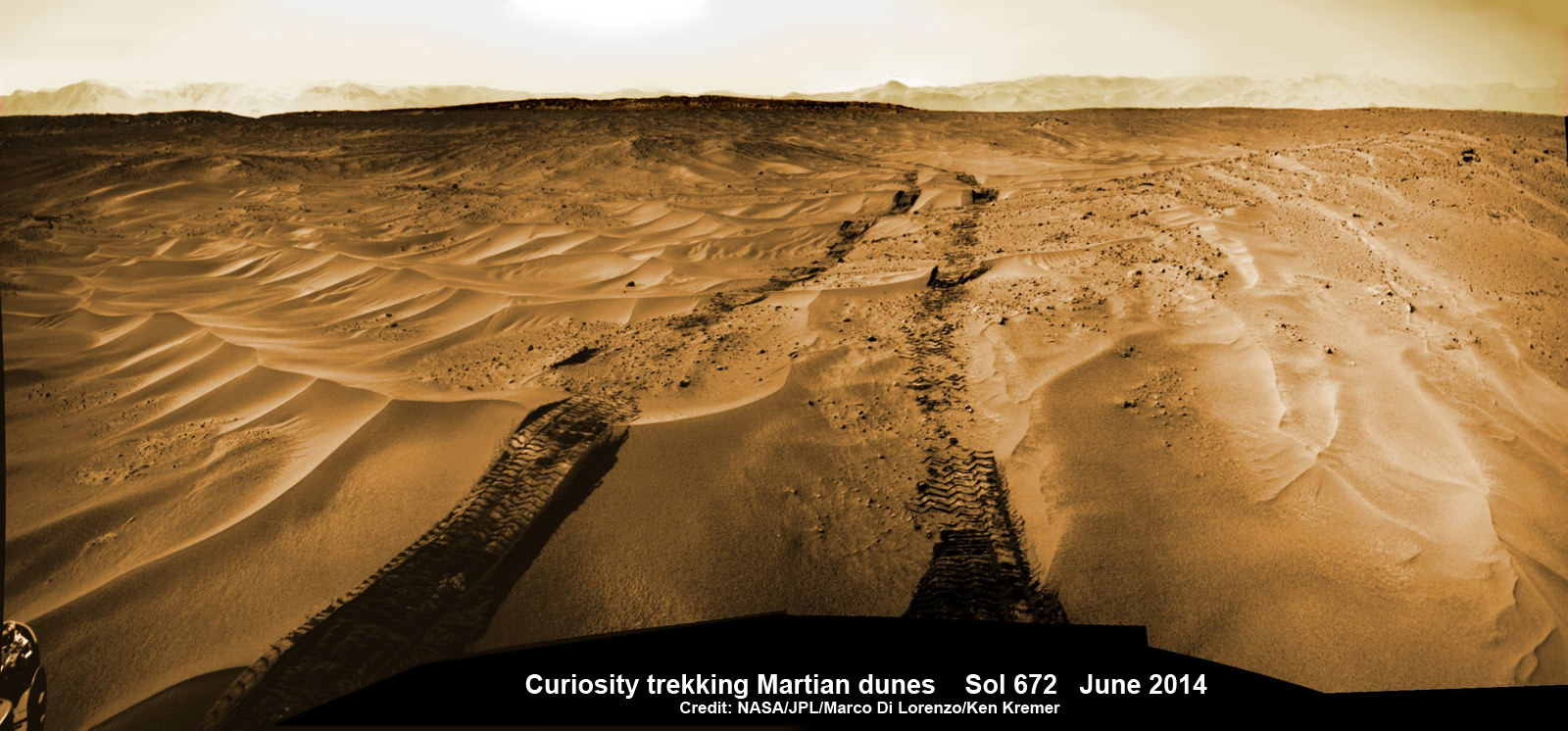
You can simultaneously experience the Martian eye view of Curiosity from above and below by checking out our Sol 672 ground level photo mosaic – below. It’s assembled from raw images taken by the mast mounted navigation camera (Navcam) showing the rovers wheel tracks and distant rim of the Gale Crater landing site.
Curiosity treks across Martian dunes and drives outside landing ellipse here, in this photo mosaic view captured on Sol 672, June 27, 2014. Navcam camera raw images stitched and colorized. Credit: NASA/JPL-Caltech/Marco Di Lorenzo/Ken Kremer – kenkremer.com
The six wheeled robot drove about 269 feet (82 meters) on June 27 traversing to the boundary of her targeted landing ellipse in safe terrain – approximately 4 miles wide and 12 miles long (7 kilometers by 20 kilometers) – for the first time since touchdown on Mars nearly two years ago on August 5, 2012 inside Gale Crater.
Curiosity celebrated another Martian milestone anniversary on June 24 (Sol 669) – 1 Martian Year on Mars!
A Martian year is equivalent to 687 Earth days, or nearly two Earth years.
1 Martian Year on Mars!
Curiosity treks to Mount Sharp in this photo mosaic view captured on Sol 669, June 24, 2014. Navcam camera raw images stitched and colorized. Credit: NASA/JPL-Caltech/Marco Di Lorenzo/Ken Kremer – kenkremer.com
The SUZ sized rover is driving as swiftly as possible to the base of Mount Sharp which dominates the center of Gale Crater and reaches 3.4 miles (5.5 km) into the Martian sky – taller than Mount Rainier.
During Year 1 on Mars, Earth’s emissary has already accomplished her primary objective of discovering a habitable zone on the Red Planet that contains the minerals necessary to support microbial life in the ancient past when Mars was far wetter and warmer billions of years ago.
To date, Curiosity’s odometer totals over 5.1 miles (8.4 kilometers) since landing inside Gale Crater on Mars in August 2012. She has taken over 165,000 images.
Curiosity still has about another 2.4 miles (3.9 kilometers) to go to reach the entry way at a gap in the treacherous sand dunes at the foothills of Mount Sharp sometime later this year.
Stay tuned here for Ken’s continuing Curiosity, Opportunity, Orion, SpaceX, Boeing, Orbital Sciences, commercial space, MAVEN, MOM, Mars and more planetary and human spaceflight news.
Mars One proposes Phoenix-like lander for first privately funded mission to the Red Planet slated to blastoff in 2018. This film solar array experiment would provide additional power. Credit: Mars One
Would you like to send your great idea for a research experiment to Mars and are searching for a method of transport?
The Mars One non-profit foundation that’s seeking settlers for a one-way trip to establish a permanent human colony on the Red Planet starting in the mid-2020’s, is now soliciting science and marketing proposals in a worldwide competition for their unmanned forerunner mission – the 2018 Mars One technology demonstration lander.
The Dutch-based Mars One team announced this week that they are seeking requests for proposals for seven payloads that would launch in August 2018 on humanities first ever privately financed robotic Red Planet lander.
Mars One hopes that the 2018 lander experiments will set the stage for liftoff of the first human colonists in 2024. Crews of four will depart every two years.
Artist’s conception of Mars One human settlement. Credit: Mars One/Brian Versteeg
The 2018 lander structure would be based on NASA’s highly successful 2007 Phoenix Mars lander – built by Lockheed Martin – which discovered and dug into water ice buried just inches beneath the topsoil in the northern polar regions of the Red Planet.
Mars One has contracted with Lockheed Martin to build the new 2018 lander.
Lockheed is also currently assembling another Phoenix-like lander for NASA named InSight which is scheduled to blast off for Mars in 2016.
The payloads being offered fall under three categories; four science demonstration payloads, a single university science experiment, and two payload spaces up for sale to the highest bidder for science or marketing or “anything in between.”
The science payload competition is open to anyone including universities, research bodies, and companies from around the world.
“Previously, the only payloads that have landed on Mars are those which NASA has selected,” said Bas Lansdorp, Co-founder & CEO of Mars One, in a statement. “We want to open up the opportunity to the entire world to participate in our mission to Mars by sending a certain payload to the surface of Mars.”
The four science demonstration payloads will test some of the technologies critical for establishing the future human settlement. They include soil acquisition experiments to extract water from the Martian soil into a useable form to test technologies for future human colonists; a thin film solar panel to demonstrate power production; and a camera system working in combination with a Mars-synchronous communications satellite to take a ‘real time’ look on Mars.
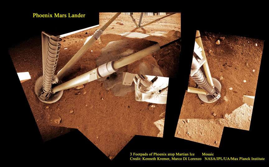
3 Footpads of Phoenix Mars Lander atop Martian Ice
Phoenix thrusters blasted away Martian soil and exposed water ice. Proposed Mars One 2018 mission will build a new Phoenix-like lander from scratch to test technologies for extracting water into a useable form for future human colonists. NASA’s InSight 2016 mission will build a new Phoenix-like lander to peer deep into the Red Planet and investigate the nature and size of the mysterious Martian core. Credit: Ken Kremer, Marco Di Lorenzo, Phoenix Mission, NASA/JPL/UA/Max Planck Institute
The single University competition payload is open to universities worldwide and “can include scientific experiments, technology demonstrations or any other exciting idea.” Click here for – submission information.
Furthermore two of the payloads are for sale “to the highest bidder” says Mars One in a statement and request for proposals document.
The payloads for sale “can take the form of scientific experiments, technology demonstrations, marketing and publicity campaigns, or any other suggested payload,” says Mars One.
“We are opening our doors to the scientific community in order to source the best ideas from around the world,” said Arno Wielders, co-founder and chief technical officer of Mars One.
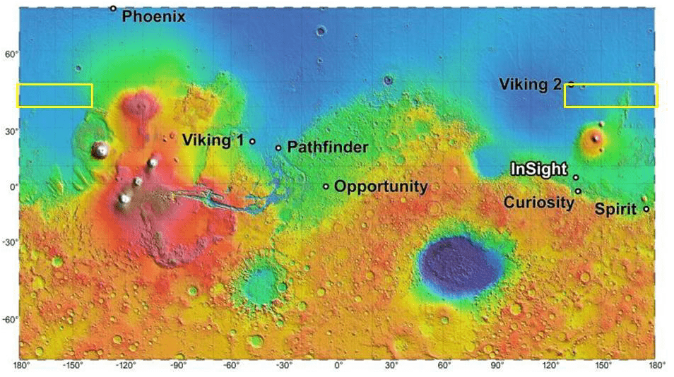
Image shows color MOLA relief with US lander landing sites (Image credit NASA/JPL-Caltech/Arizona State University). Yellow box indicates Mars One Precursor landing regions under consideration.
“The ideas that are adopted will not only be used on the lander in 2018, but will quite possibly provide the foundation for the first human colony on Mars. For anyone motivated by human exploration, there can be no greater honor than contributing to a manned mission to Mars.”
Over 200,000 Earthlings applied to Mars One to become future human colonists. That list has recently been narrowed to 705.
Stay tuned here for Ken’s continuing Curiosity, Opportunity, Orion, SpaceX, Boeing, Orbital Sciences, commercial space, MAVEN, MOM, Mars and more planetary and human spaceflight news.
Learn more about NASA’s Mars missions and Orbital Sciences Antares ISS launch on July 11 from NASA Wallops, VA in July and more about SpaceX, Boeing and commercial space and more at Ken’s upcoming presentations.
July 10/11: “Antares/Cygnus ISS Launch from Virginia” & “Space mission updates”; Rodeway Inn, Chincoteague, VA, evening