Curiosity Rover’s Proximity To Possible Water Raises Planetary Protection Concerns

View from the Curiosity rover at the foot of Aeolis Mons, before the rover starts to climb the mountain. Credit: NASA

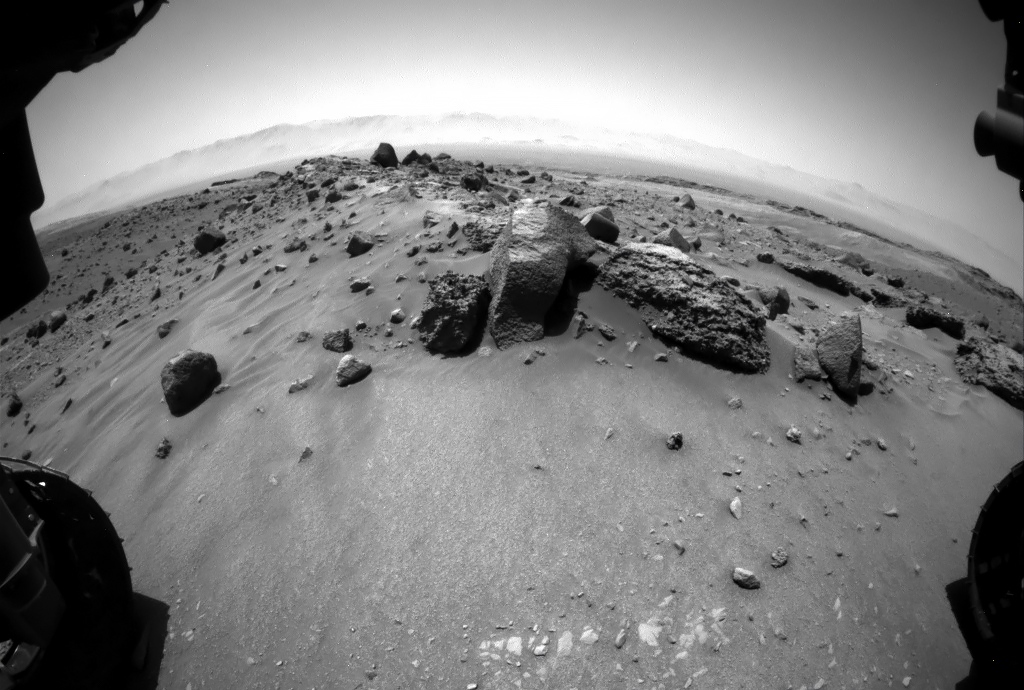
After four years on Mars, the Curiosity rover has made some pretty impressive discoveries. These have ranged from characterizing what Mars’ atmosphere was like billions of years ago to discovering organic molecules and methane there today. But arguably the biggest discovery Curiosity has made has been uncovering evidence of warm, flowing water on Mars’ surface.

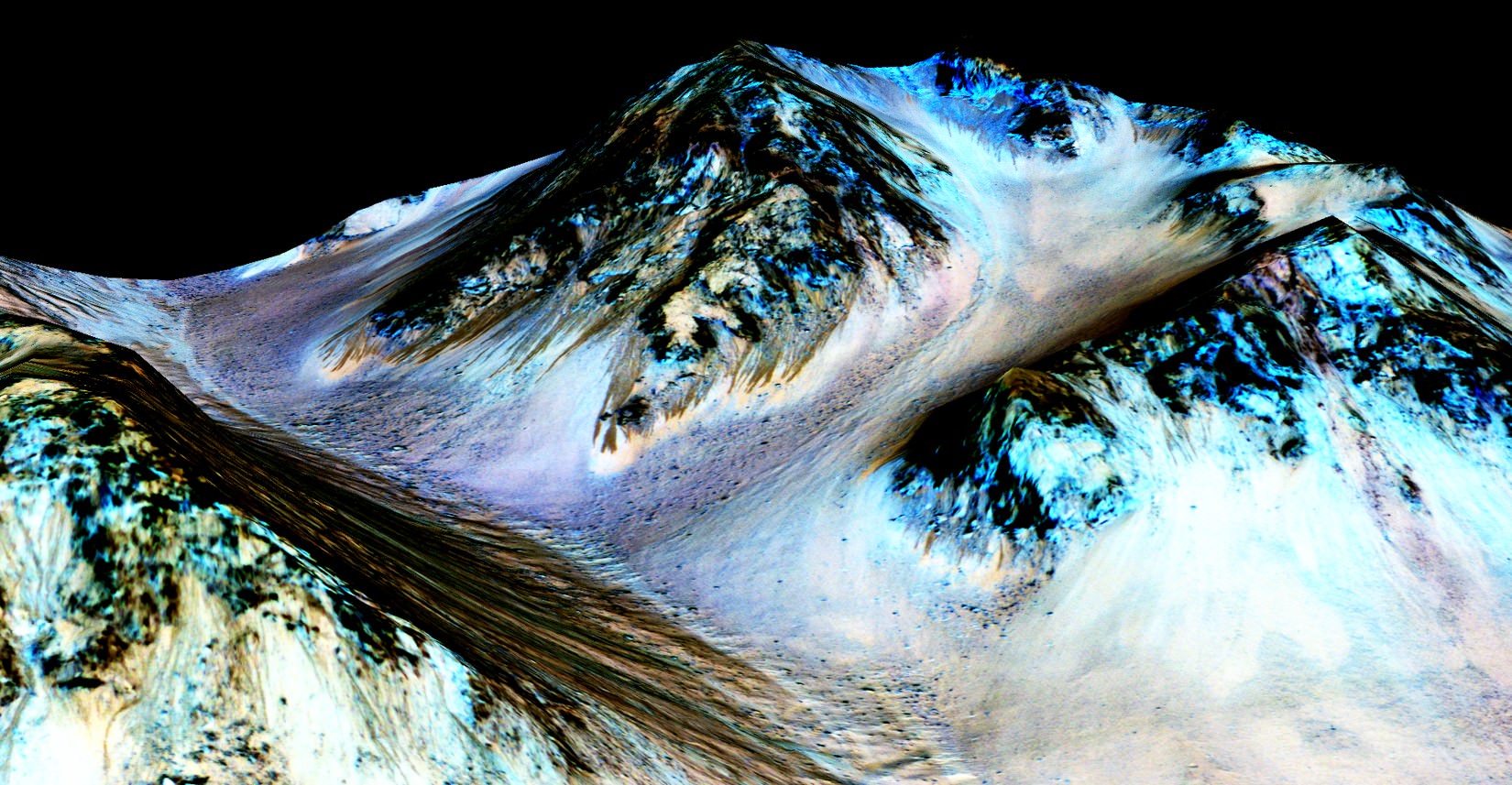
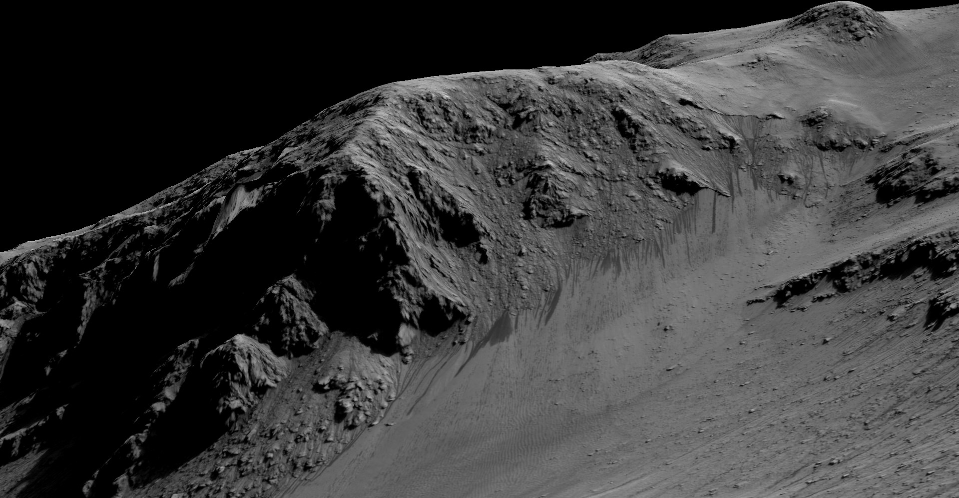
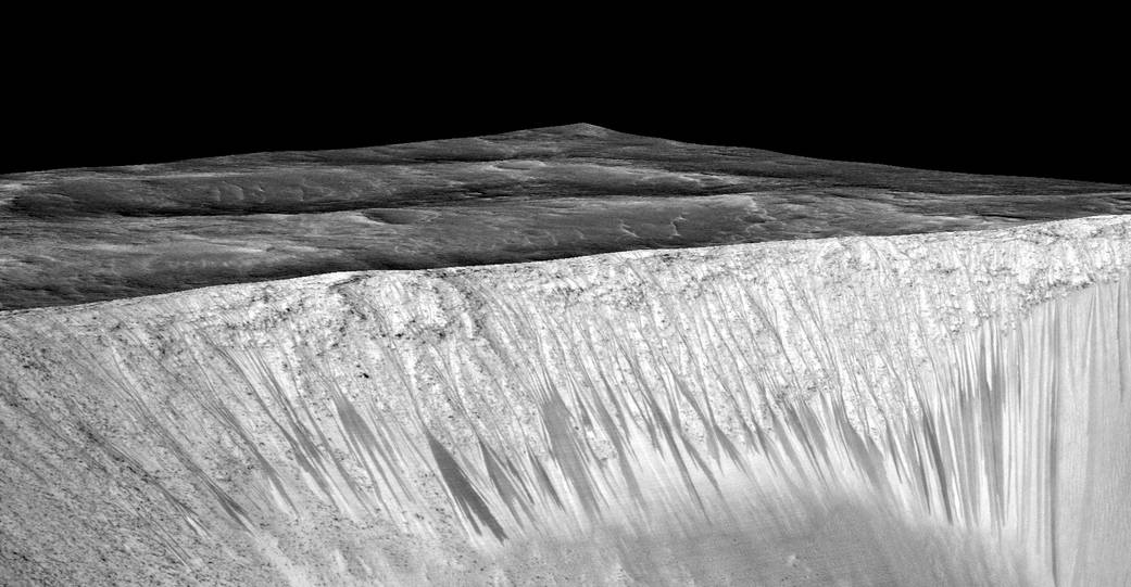
Unfortunately, now faced with what could be signs of water directly in its path, NASA is forced to enact strict protocols. These signs take the form of dark streaks that have been observed along the sloping terrain of Aeolis Mons (aka. Mount Sharp), which the rover has been preparing to climb. In order to prevent contamination, the rover must avoid any contact with them, which could mean a serious diversion.

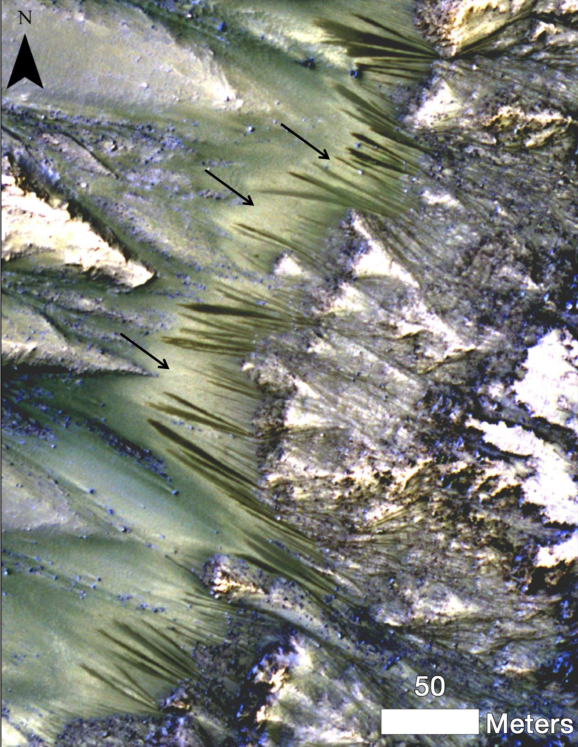
These sorts of dark streaks are known as recurring slope lineae (RSLs) because of their tendency to appear, fade away and re­appear seasonally on steep slopes. The first RSLs were reported in 2011 by the Mars Reconnaissance Orbiter in a variety of locations, and are now seen as proof that water still periodically flows on Mars (albiet in the form of salt-water).

Mosaic of the Valles Marineris hemisphere of Mars, similar to what one would see from orbital distance of 2500 km. Credit: NASA/JPL-Caltech
Mosaic of the Valles Marineris hemisphere of Mars, as it would appear from orbit. Credit: NASA/JPL-Caltech

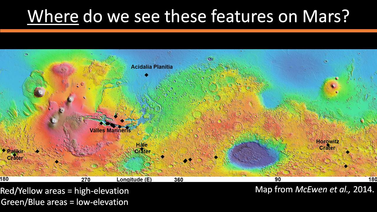
Since that time, a total of 452 possible RSLs have been observed, mostly in Mars’s southern mid-latitudes or near the equator (particularly in Mars’ Valles Marineris). They are generally a few meters wide, and appear to lengthen at the warmest times of the year, then fade during the colder times.

These seasonal flows of salt water are believed to have come from ice trapped about a meter below the surface. Ordinarily, such features would present an opportunity to conduct research. But doing so would cause the water source to be contaminated by Earth microbes aboard Curiosity. And right now, Curiosity has bigger fish to fry (so to speak).

During its planned climb, Curiosity was supposed to pass within a few kilometers of an RSL. However, if NASA determines that the risk is too high, the rover will have to alter its course. Unfortunately, that presents a major challenge, since there is currently only one clear route between Curiosity’s current location and its next destination.

But then again, Curiosity may not have to alter its course at all. Or it could find a route that lets it still accomplish its scientific goals, depending on the circumstances. As Ashwin R. Vasavada, the Project Scientist at the Mars Science Laboratory, told Universe Today via email:

“It may depend on the distance between the rover and a potentially sensitive region, for example.  Based on that understanding, we’ll determine the right course of action. For example, it may be possible to achieve Curiosity’s science goals while maintaining a safe distance. Another possible outcome is that we determine that there are no Recurring Slope Lineae on Mount Sharp.”

MRO image of Gale Crater illustrating the landing location and trek of the Rover Curiosity. In 2 years, Curiosity traversed 3 miles to reach the base of Mount Sharp. The next two years of trekking are likely to be at least as challenging. (Credits: NASA/JPL, illustration, T.Reyes)
MRO image of Gale Crater illustrating the landing location and trek of the Rover Curiosity. Credit: NASA/JPL, illustration, T.Reyes

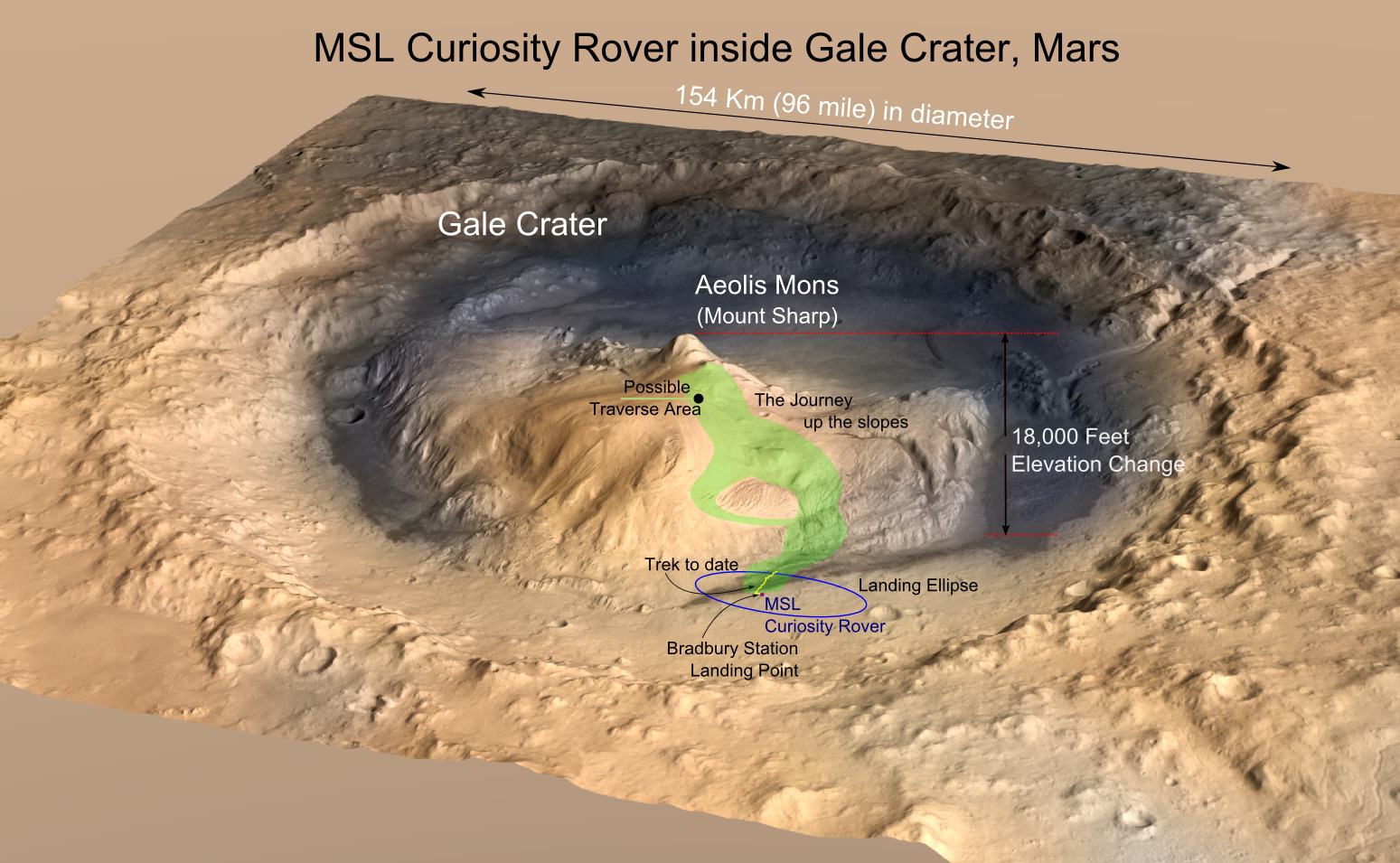
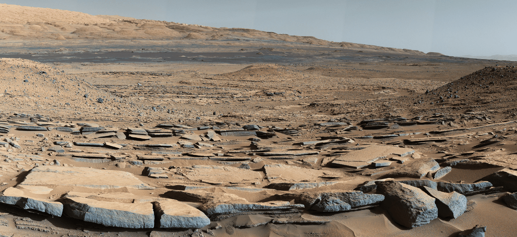
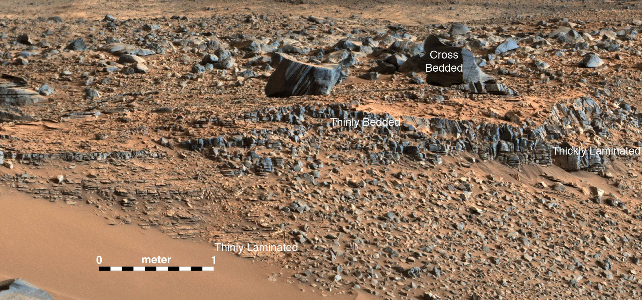
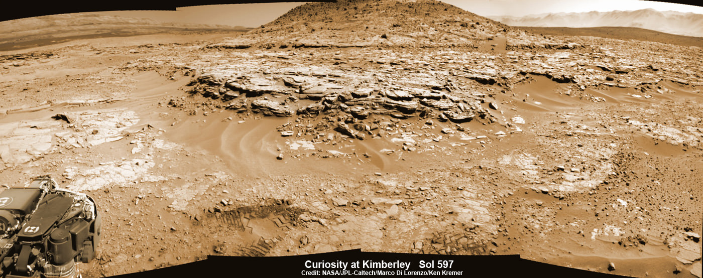
For years, NASA scientists have been seeking to obtain samples from different locations around Mount Sharp. By studying the sedimentary deposits in the mountainside, the rover’s science team hopes to see how Mars’ environment changed over the past 3 billion years. As Vasavada explained:

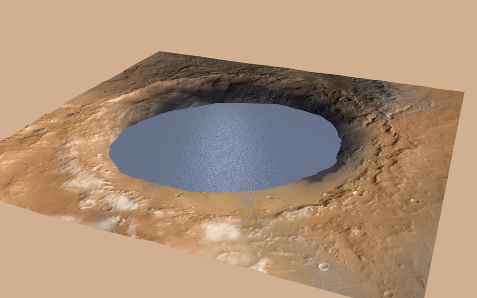
“Curiosity’s science mission has focused on understanding whether the area around 5-km high Mount Sharp ever had conditions suitable for life. We’ve already found evidence for an ancient, 3-billion-year-old habitable environment out on the plains around the mountain, and in the lowest levels of the mountain.”

“The geology indicates that a series of lakes once was present in the basin of the crater, before the mountain took shape. Curiosity will continue climbing lower Mount Sharp to see how long these habitable conditions lasted. Every step higher we go, we encounter rocks that are a bit younger, but still around 3 billion years old.”

In the end, the job of determining the risk falls to NASA’s Planetary Protection Office. In addition to reviewing the current predicament, the issue of pre-mission safety standards is also likely to come up. Prior to its deployment to Mars, the Curiosity rover was only partially sterilized, and it is currently unknown how long Earth microbes could survive in the Martian atmosphere, or how far they could be carried in Mars’ atmosphere.

These dark streaks, called recurring slope lineae, are on a sloped wall on a crater on Mars. A new study says they may have been formed by boiling water. Image: NASA/JPL-Caltech/Univ. of Arizona
These dark streaks, called recurring slope lineae (RSL), are on the sloped wall of a crater on Mars. Credit: NASA/JPL-Caltech/Univ. of Arizona

Answering these questions and coming up with new protocols that will address them in advance will come in handy for future missions – particularly the Mars 2020 Rover mission. In the course of its mission, which will include obtaining samples and leaving them behind for possible retrieval by a future crewed mission, the rover is likely to encounter several RSLs.

One of the Mars 2020 rover’s primary tasks will be finding evidence of microbial life, so ensuring that Earth microbes don’t get in the way will be of extreme importance. And with crewed missions on the horizon, knowing how we can prevent contaminating Mars with our own germs (of which there are many) is paramount!

On its currently project path, the Curiosity rover would not get closer than 2 km from the potential RSL (which it is currently 5 km from). And as Vasavada indicated, it is not known at the present time what alternate routes Curiosity could take, or if a diversion in the rover’s path will effect it’s overall mission.

“It’s unclear at this time,” he said. “But I’m optimistic that we can find a solution that protects Mars, allows us to accomplish our mission goals, and even gives us new insight into modern water on Mars, if it is there.”

Further Reading: Nature

Curiosity Rover Confirms Ancient Lake Filled Gale Crater, Boosting Chance of Life

A view from the "Kimberley" formation on Mars taken by NASA's Curiosity rover. The strata in the foreground dip towards the base of Mount Sharp, indicating flow of water toward a basin that existed before the larger bulk of the mountain formed. This image was taken by the Mast Camera (Mastcam) on Curiosity on Sol 580 of the mission and has been “white balanced” to adjust for the lighting on Mars make the sky appear light blue. Credits: NASA/JPL-Caltech/MSSS

A view from the “Kimberley” formation on Mars taken by NASA’s Curiosity rover. The strata in the foreground dip towards the base of Mount Sharp, indicating flow of water toward a basin that existed before the larger bulk of the mountain formed. This image was taken by the Mast Camera (Mastcam) on Curiosity on Sol 580 of the mission and has been “white balanced” to adjust for the lighting on Mars make the sky appear light blue. Credits: NASA/JPL-Caltech/MSSS
Story/imagery updated[/caption]

Hot on the heels of NASA’s groundbreaking announcement on Sept. 28 of the discovery that “liquid water flows intermittently” across multiple spots on the surface of today’s Mars, scientists leading NASA’s Curiosity rover mission have confirmed that an ancient lake once filled the Gale Crater site which the robot has been methodically exploring since safely landing back in August 2012 near the base of a layered mountain known as Mount Sharp.

The new research finding from the Curiosity team was just published in the journal Science on Friday, Oct. 9, and boosts the chances that alien life may have taken hold in the form of past or present day Martian microbes.

The article is titled “Wet Paleoclimate of Mars Revealed by Ancient Lakes at Gale Crater,” with John Grotzinger, the former project scientist for the Mars Science Laboratory (MSL) mission at the California Institute of Technology in Pasadena, as lead author of the new report.

Simulated view of Gale Crater Lake on Mars. This illustration depicts a lake of water partially filling Mars’ Gale Crater, receiving runoff from snow melting on the crater’s northern rim. Credit: NASA/JPL-Caltech/ESA/DLR/FU Berlin/MSSS

The new study is coauthored by four dozen team members intimately involved in Curiosity’s ongoing exploits and “confirmed that Mars was once, billions of years ago, capable of storing water in lakes over an extended period of time.”

“Observations from the rover suggest that a series of long-lived streams and lakes existed at some point between about 3.8 to 3.3 billion years ago, delivering sediment that slowly built up the lower layers of Mount Sharp,” said Ashwin Vasavada, current MSL project scientist at NASA’s Jet Propulsion Laboratory in Pasadena, California, and co-author of the new report, in a statement.

Over the past three years, the Curiosity Mars Science Laboratory rover has been traversing the floor of Gale Crater investigating scores of different rocks and outcrops with her suite of state-of-the-art instruments, and painstakingly analyzing drill samples cored from their interiors with a pair of chemistry labs to elucidate the history of Mars based on NASA’s “follow the water” mantra.

The soundness of NASA Mars exploration strategy has repeatedly borne fruit and is now validated by overwhelming measurements gathered during Curiosity’s epic Martian trek confirming the existence of a lake where Mount Sharp now stands.

Exploring the sedimentary layers of Mount Sharp, which towers 3.4 miles (5.5 kilometers) into the Martian sky, is the primary destination and goal of the rovers long term scientific expedition on the Red Planet.

Since the nail biting touchdown on Aug. 5, 2012, Curiosity has been on a path towards the sedimentary layers at the lower reaches of Mount Sharp at the center of Gale Crater.

Curiosity rover panorama of Mount Sharp captured on June 6, 2014 (Sol 651) during traverse inside Gale Crater.  Note rover wheel tracks at left.  She will eventually ascend the mountain at the ‘Murray Buttes’ at right later this year. Assembled from Mastcam color camera raw images and stitched by Marco Di Lorenzo and Ken Kremer.   Credit:   NASA/JPL/MSSS/Marco Di Lorenzo/Ken Kremer-kenkremer.com
Curiosity rover panorama of Mount Sharp captured on June 6, 2014 (Sol 651) during traverse inside Gale Crater. Note rover wheel tracks at left. She will eventually ascend the mountain at the ‘Murray Buttes’ at right later this year. Assembled from Mastcam color camera raw images and stitched by Marco Di Lorenzo and Ken Kremer. Credit: NASA/JPL/MSSS/Marco Di Lorenzo/Ken Kremer-kenkremer.com

The car sized robot arrived at the foothills of Mount Sharp a year ago in September 2014, marking the start of the mountains formal investigation.

But the origin of Mount Sharp has been up for debate.

With the new data, researchers believe that the ancient lake helped fill Gale Crater with sediments deposited in layers over time that formed the foundation for Mount Sharp which now dominates the center of the crater.

“What we thought we knew about water on Mars is constantly being put to the test,” said Michael Meyer, lead scientist for NASA’s Mars Exploration Program at NASA Headquarters in Washington.

“It’s clear that the Mars of billions of years ago more closely resembled Earth than it does today. Our challenge is to figure out how this more clement Mars was even possible, and what happened to that wetter Mars.”

Mars was far wetter and warmer and possessed a much more massive atmosphere billions of years ago than it does today.

An image taken at the "Hidden Valley" site, en-route to Mount Sharp, by NASA's Curiosity rover. A variety of mudstone strata in the area indicate a lakebed deposit, with river- and stream-related deposits nearby.  This image was taken by the Mast Camera (Mastcam) on Curiosity on Sol 703.  Credits: NASA/JPL-Caltech/MSSS
An image taken at the “Hidden Valley” site, en-route to Mount Sharp, by NASA’s Curiosity rover. A variety of mudstone strata in the area indicate a lakebed deposit, with river- and stream-related deposits nearby. This image was taken by the Mast Camera (Mastcam) on Curiosity on Sol 703. Credits: NASA/JPL-Caltech/MSSS

Gale Crater lake existed long before Mount Sharp ever formed during that period billions of years ago when the Red Planet was far warmer and wetter.

“Paradoxically, where there is a mountain today there was once a basin, and it was sometimes filled with water,” said Grotzinger, in a statement.

“We see evidence of about 250 feet (75 meters) of sedimentary fill, and based on mapping data from NASA’s Mars Reconnaissance Orbiter and images from Curiosity’s camera, it appears that the water-transported sedimentary deposition could have extended at least 500 to 650 feet (150 to 200) meters above the crater floor.”

Indeed there is additional evidence that the sedimentary deposits from interaction with water may be as thick as one-half mile (800 meters) above the crater floor. However beyond that there is no evidence of hydrated strata further up Mount Sharp.

But for reasons we are still trying to decipher and comprehend, Mars underwent radical climactic change between 3 and 4 billion years ago and was transformed from an ancient wet world, potentially hospitable to life, to a cold, dry desiccated world, rather inhospitable to life, that exists today.

Curiosity’s Panoramic view of Mount Remarkable at ‘The Kimberley Waypoint’ where rover conducted 3rd drilling campaign inside Gale Crater on Mars. The navcam raw images were taken on Sol 603, April 17, 2014, stitched and colorized. Credit: NASA/JPL-Caltech/Ken Kremer – kenkremer.com/Marco Di Lorenzo.  Featured on APOD - Astronomy Picture of the Day on May 7, 2014
Curiosity’s Panoramic view of Mount Remarkable at ‘The Kimberley Waypoint’ where rover conducted 3rd drilling campaign inside Gale Crater on Mars. The navcam raw images were taken on Sol 603, April 17, 2014, stitched and colorized. Credit: NASA/JPL-Caltech/Ken Kremer – kenkremer.com/Marco Di Lorenzo. Featured on APOD – Astronomy Picture of the Day on May 7, 2014

Unlocking the mysteries, mechanisms and time periods of Mars climate change, loss of a thick atmosphere, ability to sustain liquid surface water and searching for organic compounds and for evidence of past or present habitable zones favorable to life are the questions driving NASA’s Mars Exploration program

Curiosity has already accomplished her primary objective of discovering a habitable zone on the Red Planet – at the Yellowknife Bay area – that contains the minerals necessary to support microbial life in the ancient past when Mars was far wetter and warmer billions of years ago.

NASA’s Curiosity rover looks back to ramp with potential 4th drill site target at ‘Bonanza King’ rock outcrop in ‘Hidden Valley’ in this photo mosaic view captured on Aug. 6, 2014, Sol 711.  Inset shows results of brushing on Aug. 17, Sol 722, that revealed gray patch beneath red dust.  Note the rover’s partial selfie, valley walls, deep wheel tracks in the sand dunes and distant rim of Gale crater beyond the ramp. Navcam camera raw images stitched and colorized.  Credit: NASA/JPL-Caltech/Ken Kremer-kenkremer.com/Marco Di Lorenzo
NASA’s Curiosity rover looks back to ramp with potential 4th drill site target at ‘Bonanza King’ rock outcrop in ‘Hidden Valley’ in this photo mosaic view captured on Aug. 6, 2014, Sol 711. Inset shows results of brushing on Aug. 17, Sol 722, that revealed gray patch beneath red dust. Note the rover’s partial selfie, valley walls, deep wheel tracks in the sand dunes and distant rim of Gale crater beyond the ramp. Navcam camera raw images stitched and colorized. Credit: NASA/JPL-Caltech/Ken Kremer-kenkremer.com/Marco Di Lorenzo

“We have tended to think of Mars as being simple,” Grotzinger mused. “We once thought of the Earth as being simple too. But the more you look into it, questions come up because you’re beginning to fathom the real complexity of what we see on Mars. This is a good time to go back to reevaluate all our assumptions. Something is missing somewhere.”

Curiosity recently celebrated 1000 Sols of exploration on Mars on May 31, 2015 – detailed here with our Sol 1000 mosaic by Marco Di Lorenzo and Ken Kremer also featured at Astronomy Picture of the Day on June 13, 2015.

As of today, Sol 1129, October 10, 2015, she has driven some 6.9 miles (11.1 kilometers) kilometers and taken over 274,000 amazing images.

Curiosity is at the vanguard of Earth’s fleet of seven robotic missions paving the path for NASA’s plans to send humans on a ‘Journey to Mars’ in the 2030s.

Stay tuned here for Ken’s continuing Earth and planetary science and human spaceflight news.

Ken Kremer

Curiosity Mars rover captured this panoramic view of a butte called "Mount Remarkable" and surrounding outcrops at “The Kimberley " waypoint on April 11, 2014, Sol 597. Colorized navcam photomosaic was stitched by Marco Di Lorenzo and Ken Kremer.  Credit: NASA/JPL-Caltech/Marco Di Lorenzo/Ken Kremer - kenkremer.com
Curiosity Mars rover captured this panoramic view of a butte called “Mount Remarkable” and surrounding outcrops at “The Kimberley ” waypoint on April 11, 2014, Sol 597. Colorized navcam photomosaic was stitched by Marco Di Lorenzo and Ken Kremer. Credit: NASA/JPL-Caltech/Marco Di Lorenzo/Ken Kremer – kenkremer.com

NASA Discovers Salty Liquid Water Flows Intermittently on Mars Today, Bolstering Chance for Life

These dark, narrow, 100 meter-long streaks called recurring slope lineae flowing downhill on Mars are inferred to have been formed by contemporary flowing water. However, a new study by planetary scientists indicates that these may actually be the result of dry flows. Credits: NASA/JPL/University of Arizona

These dark, narrow, 100 meter-long streaks called recurring slope lineae flowing downhill on Mars are inferred to have been formed by contemporary flowing water. Recently, planetary scientists detected hydrated salts on these slopes at Hale crater, corroborating their original hypothesis that the streaks are indeed formed by liquid water. The blue color seen upslope of the dark streaks are thought not to be related to their formation, but instead are from the presence of the mineral pyroxene.

The image is produced by draping an orthorectified Infrared-Red-Blue/Green(IRB)) false color image on a Digital Terrain Model (DTM). This model was produced by researchers at the University of Arizona, much like the High Resolution Imaging Science Experiment (University of Arizona). The vertical exaggeration is 1.5.

NASA and Mars planetary scientists announced today (Sept. 28) that salty “liquid water flows intermittently” across multiple spots on the surface of today’s Mars – trumpeting a major scientific discovery with far reaching implications regarding the search for life beyond Earth and bolstering the chances for the possible existence of present day Martian microbes.

Utilizing spectroscopic measurements and imaging gathered by NASA’s Mars Reconnaissance Orbiter (MRO), researchers found the first strong evidence confirming that briny water flows on the Red Planet today along dark streaks moving downhill on crater slopes and mountain sides, during warmer seasons.

“Mars is not the dry, arid planet that we thought of in the past. Today we announce that under certain circumstances, liquid water has been found on Mars,” said Jim Green, NASA Planetary Science Director at NASA Headquarters, at a media briefing held today, Sept 28.

“When you look at Earth, water is an essential ingredient. Everywhere we go where there’s liquid water, whether its deep in the Earth or in the arid regions, we find life. This is tremendously exciting.”

“We haven’t been able to answer the question – does life exist beyond Earth? But following the water is a critical element of that. We now have great opportunities to be in the right locations on Mars to thoroughly investigate that,” Green elaborated.

“Water! Strong evidence that liquid water flows on present-day Mars,” NASA officials tweeted about the discovery.

The evidence comes in the form of the detection of mysterious dark streaks, as long as 100 meters, showing signatures of hydrated salt minerals periodically flowing in liquid water down steep slopes on the Red Planet that “appear to ebb and flow over time.”

The source of the water is likely from the shallow subsurface or possibly absorbed from the atmosphere.

Dark narrow streaks called recurring slope lineae emanating out of the walls of Garni crater on Mars. The dark streaks here are up to few hundred meters in length. They are hypothesized to be formed by flow of briny liquid water on Mars. The image is produced by draping an orthorectified (RED) image (ESP_031059_1685) on a Digital Terrain Model (DTM) of the same site produced by High Resolution Imaging Science Experiment (University of Arizona). Vertical exaggeration is 1.5.    Credits: NASA/JPL/University of Arizona
Dark narrow streaks called recurring slope lineae emanating out of the walls of Garni crater on Mars. The dark streaks here are up to few hundred meters in length. They are hypothesized to be formed by flow of briny liquid water on Mars. The image is produced by draping an orthorectified (RED) image (ESP_031059_1685) on a Digital Terrain Model (DTM) of the same site produced by High Resolution Imaging Science Experiment (University of Arizona). Vertical exaggeration is 1.5. Credits: NASA/JPL/University of Arizona

Water is a key prerequisite for the formation and evolution of life as we know it. So the new finding significantly bolsters the chances that present day extant life could exist on the Red Planet.

“Our quest on Mars has been to ‘follow the water,’ in our search for life in the universe, and now we have convincing science that validates what we’ve long suspected,” said John Grunsfeld, astronaut and associate administrator of NASA’s Science Mission Directorate in Washington.

“This is a significant development, as it appears to confirm that water — albeit briny — is flowing today on the surface of Mars.”

“This increases the chance that life could exist on Mars today,” noted Grunsfeld.

The data were gathered by and the conclusions are based on using two scientific instruments – the high resolution imaging spectrometer on MRO known as High Resolution Imaging Science Experiment (HiRISE), as well as MRO’s mineral mapping Compact Reconnaissance Imaging Spectrometer for Mars (CRISM).

The mysterious dark streaks of downhill flows are known as recurring slope lineae (RSL).

They were first detected in 2010 at dozens of sites on the sun facing slopes of deep craters by Lujendra Ojha, then a University of Arizona undergraduate student.

The new finding is highly significant because until today’s announcement, there was no strong evidence that liquid water could actually exist on the Martian surface because the atmospheric pressure was thought to be far too low – its less than one percent of Earth’s.

The flow of water is occasional and not permanent, seasonally variable and dependent on having just the right mix of atmospheric, temperature and surface conditions with salt deposits on Mars.

Portions of Mars were covered with an ocean of water billions of years ago when the planet was far warmer and more hospitable to life. But it underwent a dramatic climate change some 3 billion years ago and lost most of that water.

The RSL with flowing water appear in at least three different locations on Mars – including Hale crater, Horowitz crater and Palikir crater – when temperatures are above minus 10 degrees Fahrenheit (minus 23 Celsius). They appear during warm seasons, fade in cooler seasons and disappear during colder times.

Pure surface water ice would simply sublimate and evaporate away as the temperature rises. Mixing in surface salts lowers the melting point of ice, thereby allowing the water to potentially liquefy on Mars surface for a certain period of time rather than sublimating rapidly away.

“These are dark streaks that form in late spring, grow through the summer and then disappear in the fall,” said Michael Meyer lead scientist for the Mars Exploration Program at NASA Headquarters, at the media briefing.

Years of painstaking effort and laboratory work was required to verify and corroborate the finding of flowing liquid water.

“It took multiple spacecraft over several years to solve this mystery, and now we know there is liquid water on the surface of this cold, desert planet,” said Meyer. “It seems that the more we study Mars, the more we learn how life could be supported and where there are resources to support life in the future.”

The dark, narrow streaks flowing downhill on Mars at sites such as this portion of Horowitz Crater are inferred to be formed by seasonal flow of water on modern-day Mars. The streaks are roughly the length of a football field. These dark features on the slopes are called "recurring slope lineae" or RSL. The imaging and topographical information in this processed view come from the High Resolution Imaging Science Experiment (HiRISE) camera on NASA's Mars Reconnaissance Orbiter.   Credit: NASA/JPL-Caltech/Univ. of Arizona
The dark, narrow streaks flowing downhill on Mars at sites such as this portion of Horowitz Crater are inferred to be formed by seasonal flow of water on modern-day Mars. The streaks are roughly the length of a football field. These dark features on the slopes are called “recurring slope lineae” or RSL. The imaging and topographical information in this processed view come from the High Resolution Imaging Science Experiment (HiRISE) camera on NASA’s Mars Reconnaissance Orbiter. Credit: NASA/JPL-Caltech/Univ. of Arizona

Along with the media announcement, the researchers published their findings today in a refereed scientific paper in the Sept. 28 issue of Nature Geoscience.

“We found the hydrated salts only when the seasonal features were widest, which suggests that either the dark streaks themselves or a process that forms them is the source of the hydration. In either case, the detection of hydrated salts on these slopes means that water plays a vital role in the formation of these streaks,” said Lujendra Ojha, now at the Georgia Institute of Technology (Georgia Tech) in Atlanta, and lead author of the Sept. 28 publication in Nature Geoscience.

The scientists “interpret the spectral signatures as caused by hydrated minerals called perchlorates.”

Ojha said the chemical signatures from CRISM were most consistent with the detection of mixtures of magnesium perchlorate, magnesium chlorate and sodium perchlorate, based on lab experiments.

“Some perchlorates have been shown to keep liquids from freezing even when conditions are as cold as minus 94 degrees Fahrenheit (minus 70 Celsius).”

Perchlorates have previously been detected in Martian soil by two of NASA’s surface missions – the Phoenix lander and the Curiosity rover. There is also some evidence that NASA’s Viking missions in the 1970s measured signatures of these salts.

On Earth concentration of perchlorates are found in deserts.

This also marks the first time perchlorates have been identified from Mars orbit.

Locations of RSL features on Mars

NASA’s overriding agency wide goal is to send humans on a ‘Journey to Mars’ in the 2030s.

So NASA astronaut Mark Kelly exclaimed that he was also super excited about the findings, from his perch serving as Commander aboard the International Space Station (ISS), where he is a member of the first ever “1 Year ISS Mission Crew” aimed at learning how the human body will adapt to the long term missions required to send astronauts to Mars and back.

“One reason why NASA’s discovery of liquid water on #Mars is so exciting: we know anywhere there’s water on Earth, there’s some form of life,” Kelly tweeted today from on board the ISS, upon hearing today’s news.

The discovery of liquid water on Mars could also be a boon to future astronauts who could use it as a natural resource to ‘live off the land’ for sustenance and to make rocket fuel.

“If going to Mars on my Year In Space, I’d arrive soon to find water! H20 > rocket fuel, which means I could find my way back home too!,” Kelly wrote on his Facebook page.

“When most people talk about water on Mars, they’re usually talking about ancient water or frozen water,” Ojha explained.

“Now we know there’s more to the story. This is the first spectral detection that unambiguously supports our liquid water-formation hypotheses for RSL.”

Stay tuned here for Ken’s continuing Earth and planetary science and human spaceflight news.

Ken Kremer

Are These Water Flows On Mars? Quite Possibly, New Observations Reveal

Palikir Crater as seen by the Mars Reconnaissance Orbiter's High Resolution Imaging Science Experiment (HiRISE) camera. Visible are warm-season flows called "recurring slope linea" that could have been created by salty liquid water. Credit: NASA/JPL-Caltech/UA/JHU-APL

What a tangled web of water and water ice stories on Mars. There’s likely some underground. There’s definitely some at the north pole. And we are pretty certain water flowed there in the ancient past. But what about surface water today, right now, in the view of our many orbiting cameras at the Red Planet?

One hotspot of debate are flows called “recurring slope lineae”, which are features that appear in warmer temperatures. These would seem to imply some kind of briny water flowing. A team recently checked out 13 of these sites. While they didn’t find any water or salt evidence in the spectra, they did find more iron-bearing minerals on “RSL slopes” compared to those that aren’t. So what’s going on?

“We still don’t have a smoking gun for existence of water in RSL, although we’re not sure how this process would take place without water,” stated Lujendra Ojha, a graduate student at the Georgia Institute of Technology in Atlanta who led two reports on these features. Pictures were taken using NASA’s Mars Reconnaissance Orbiter’s High Resolution Imaging Science Experiment (HiRISE), which is led by the University of Arizona.

Palikir Crater as seen by the Mars Reconnaissance Orbiter's High Resolution Imaging Science Experiment (HiRISE) camera. Visible are warm-season flows called "recurring slope linea" that could have been created by salty liquid water. Credit: NASA/JPL-Caltech/UA/JHU-APL
Palikir Crater as seen by the Mars Reconnaissance Orbiter’s High Resolution Imaging Science Experiment (HiRISE) camera. Visible are warm-season flows called “recurring slope linea” that could have been created by salty liquid water. Credit: NASA/JPL-Caltech/UA/JHU-APL

It’s possible that the grains are being sorted by size (more plainly speaking, taking the fine dust away and leaving the larger grains behind), which could happen either with water or without it. Or, water might be present but not in a way that is obvious immediately if the area got darker because of moisture, or the minerals became oxidized. Water could be “missing” from these observations because they took place in the afternoon (meaning they could miss morning dew), or because the dark flows are smaller than the sample size in the picture.

While researchers still aren’t sure, the team says they still believe it’s salty water of some sort that is flowing despite very cold temperatures on Mars.

“The flow of water, even briny water, anywhere on Mars today would be a major discovery, impacting our understanding of present climate change on Mars and possibly indicating potential habitats for life near the surface on modern Mars,” said Richard Zurek, MRO project scientist who is at NASA’s Jet Propulsion Laboratory in California.

A related paper also found that RSL sites are rare on Mars, appearing in only 13 of 200 sites surveyed with similar slopes, latitudes and other features. You can read the accepted versions of the reports as they appear in Geophysical Research Letters and Icarus.