Astonishing ‘Snakeskin’ Textured Mountains Discovered on Pluto

This color image of Pluto taken by NASA’s New Horizons spacecraft shows rounded and bizarrely textured mountains, informally named the Tartarus Dorsa, rise up along Pluto’s terminator and show intricate but puzzling patterns of blue-gray ridges and reddish material in between. This view, roughly 330 miles (530 kilometers) across, combines blue, red and infrared images taken by the Ralph/Multispectral Visual Imaging Camera (MVIC) on July 14, 2015, and resolves details and colors on scales as small as 0.8 miles (1.3 kilometers). Credits: NASA/JHUAPL/SWRI

The more we learn about Pluto, the weirder and weirder it gets.

The newest batch of high resolution Plutonian images has yielded “astonishing” discoveries of previously unseen ‘snakeskin’ textured mountains, that are simultaneously “dazzling and mystifying” scientists analyzing the latest data just returned from NASA’s New Horizons spacecraft.

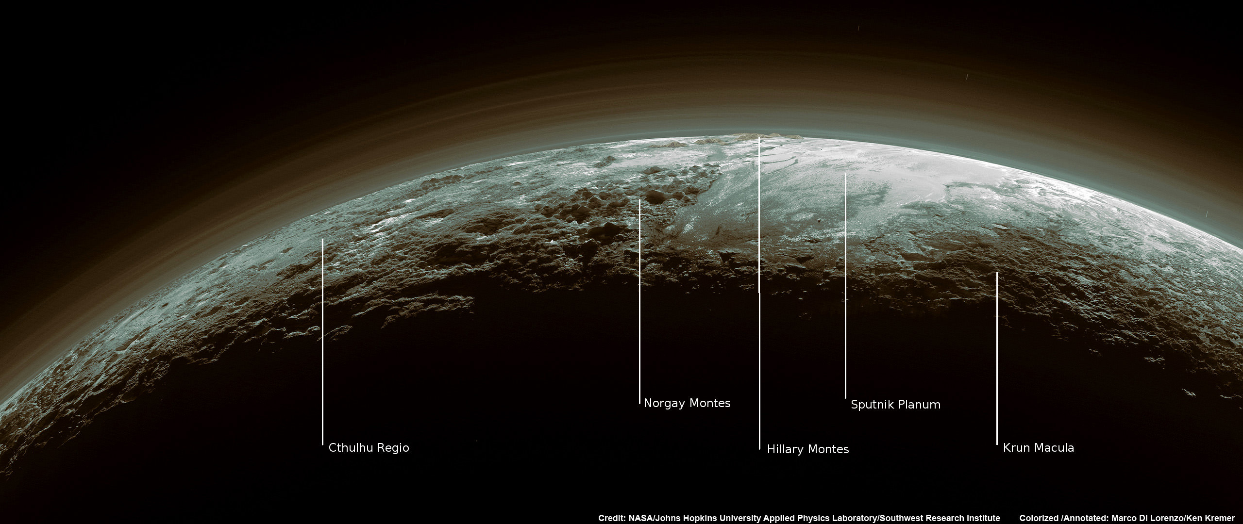
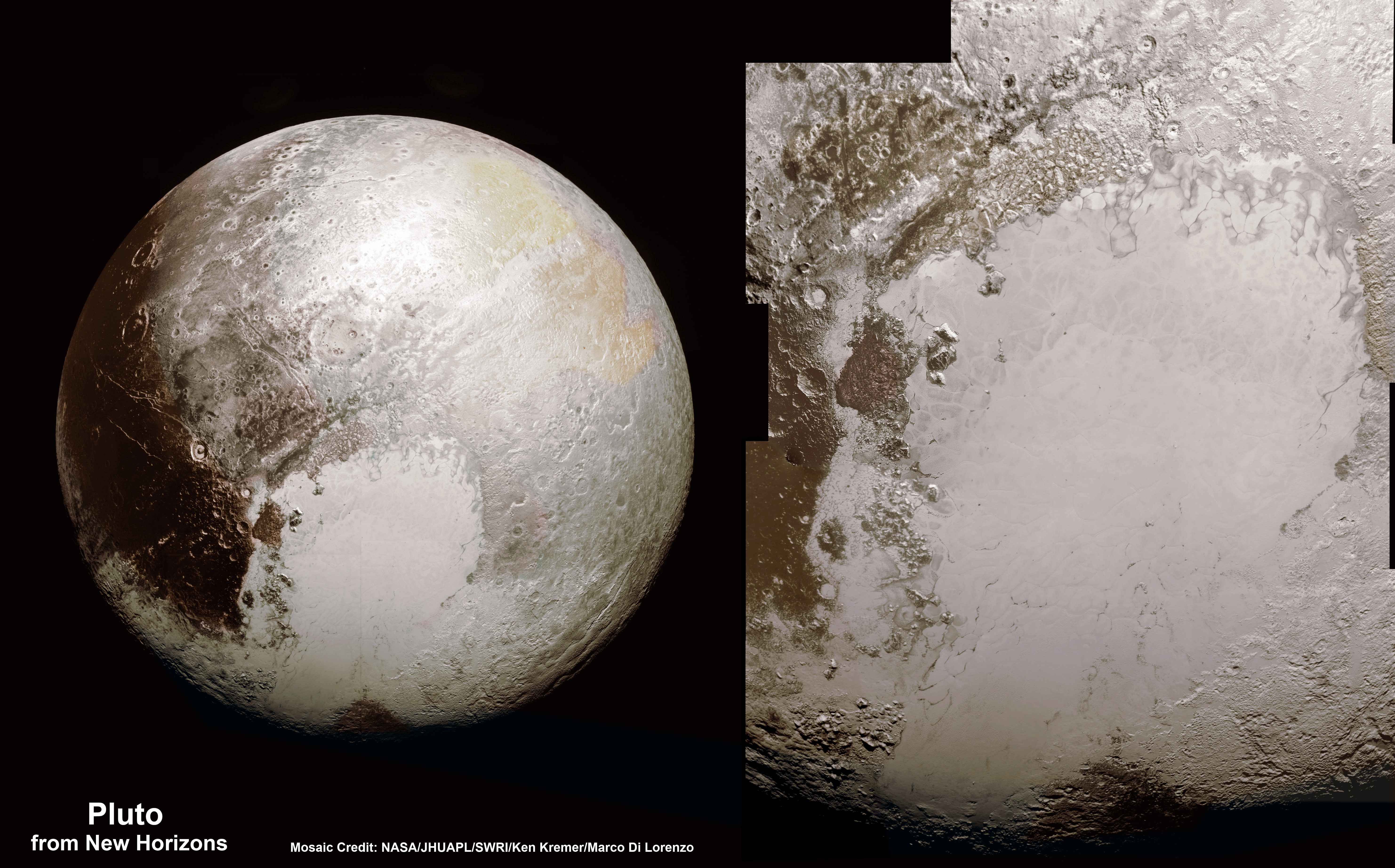
New Horizons swooped past the Pluto planetary system during mankind’s history making first encounter on July 14, 2015 at a distance of 50,000 miles (80,000 kilometers).

The piano shaped probe gathered about 50 gigabits of data as it hurtled past Pluto, its largest moon Charon and four smaller moons.

Data from that priceless, once in a lifetime flyby is now trickling back to Earth.

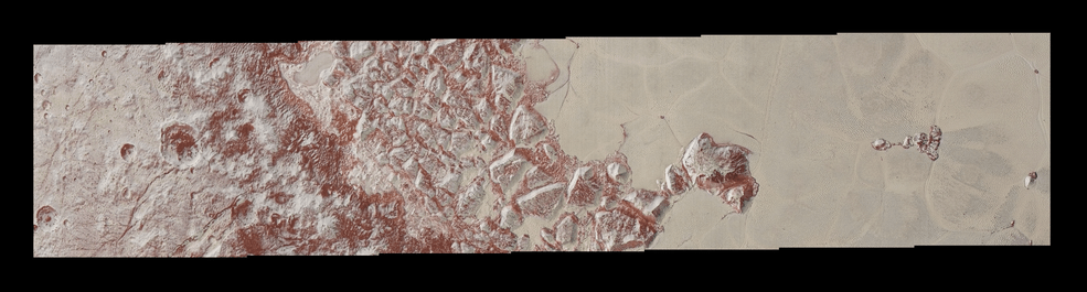
The ‘snakeskin’ feature on Pluto’s utterly bizarre surface was unveiled to “astonished” scientists scrutinizing the latest data dump received over the past week, that included images taken by the Ralph instruments Multispectral Visual Imaging Camera (MVIC).

Features as small as 0.8 miles (1.3 kilometers) are resolved in detail.

The MVIC image stretches about 330 miles (530 kilometers) across the ‘snakeskin’ like landscape composed of rounded and bizarrely textured mountains that are informally named Tartarus Dorsa and that borders the bodies day-night terminator.

It shows intricate patterns of blue-gray ridges and reddish material in between that are puzzling researchers.

“It’s a unique and perplexing landscape stretching over hundreds of miles,” said William McKinnon, New Horizons Geology, Geophysics and Imaging (GGI) team deputy lead from Washington University in St. Louis.

“It looks more like tree bark or dragon scales than geology. This’ll really take time to figure out; maybe it’s some combination of internal tectonic forces and ice sublimation driven by Pluto’s faint sunlight.”

The Ralph/MVIC image is actually a composite of blue, red and infrared images.

The image of Tartarus Dorsa reveals a “multitude of previously unseen topographic and compositional details. It captures a vast rippling landscape of strange, aligned linear ridges that has astonished New Horizons team members,” say officials.

NASA’s New Horizons spacecraft captured this high-resolution enhanced color view of Pluto on July 14, 2015. The image combines blue, red and infrared images taken by the Ralph/Multispectral Visual Imaging Camera (MVIC). Pluto’s surface sports a remarkable range of subtle colors, enhanced in this view to a rainbow of pale blues, yellows, oranges, and deep reds. Many landforms have their own distinct colors, telling a complex geological and climatological story that scientists have only just begun to decode. The image resolves details and colors on scales as small as 0.8 miles (1.3 kilometers).  The viewer is encouraged to zoom in on the image on a larger screen to fully appreciate the complexity of Pluto’s surface features.   Credit: NASA/JHUAPL/SwRI
NASA’s New Horizons spacecraft captured this high-resolution enhanced color view of Pluto on July 14, 2015. The image combines blue, red and infrared images taken by the Ralph/Multispectral Visual Imaging Camera (MVIC). Pluto’s surface sports a remarkable range of subtle colors, enhanced in this view to a rainbow of pale blues, yellows, oranges, and deep reds. Many landforms have their own distinct colors, telling a complex geological and climatological story that scientists have only just begun to decode. The image resolves details and colors on scales as small as 0.8 miles (1.3 kilometers). The viewer is encouraged to zoom in on the image on a larger screen to fully appreciate the complexity of Pluto’s surface features. Credit: NASA/JHUAPL/SwRI

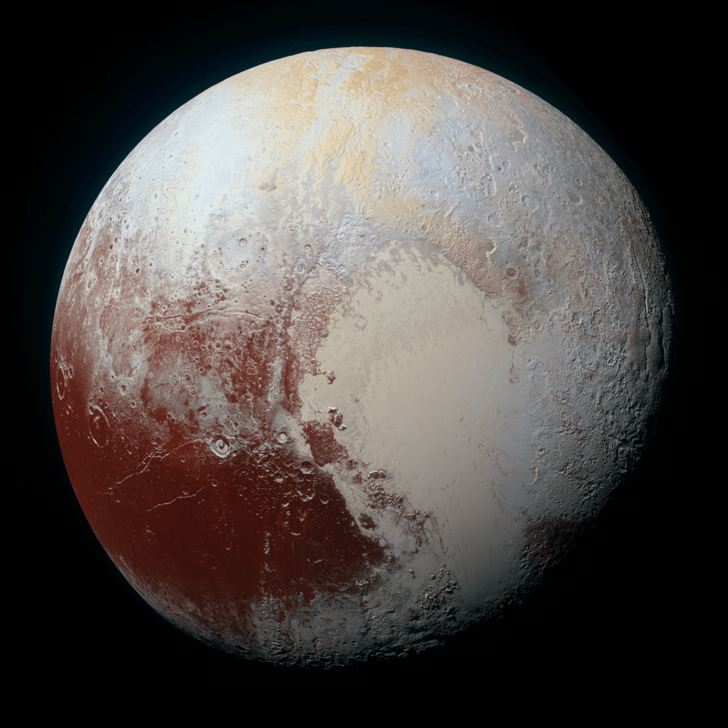
Another wider angle global view of Pluto downlinked on Sept. 19 shows a new “extended color” view of Pluto with an the extraordinarily rich color palette of the planet.

“We used MVIC’s infrared channel to extend our spectral view of Pluto,” said John Spencer, a GGI deputy lead from Southwest Research Institute (SwRI) in Boulder, Colorado.

“Pluto’s surface colors were enhanced in this view to reveal subtle details in a rainbow of pale blues, yellows, oranges, and deep reds. Many landforms have their own distinct colors, telling a wonderfully complex geological and climatological story that we have only just begun to decode.”

The image resolves details and colors on scales as small as 0.8 miles (1.3 kilometers).

High-resolution images of Pluto taken by NASA’s New Horizons spacecraft just before closest approach on July 14, 2015, reveal features as small as 270 yards (250 meters) across, from craters to faulted mountain blocks, to the textured surface of the vast basin informally called Sputnik Planum. Enhanced color has been added from the global color image. This image is about 330 miles (530 kilometers) across. For optimal viewing, zoom in on the image on a larger screen.  Credits: NASA/JHUAPL/SWRI
High-resolution images of Pluto taken by NASA’s New Horizons spacecraft just before closest approach on July 14, 2015, reveal features as small as 270 yards (250 meters) across, from craters to faulted mountain blocks, to the textured surface of the vast basin informally called Sputnik Planum. Enhanced color has been added from the global color image. This image is about 330 miles (530 kilometers) across. For optimal viewing, zoom in on the image on a larger screen. Credits: NASA/JHUAPL/SWRI

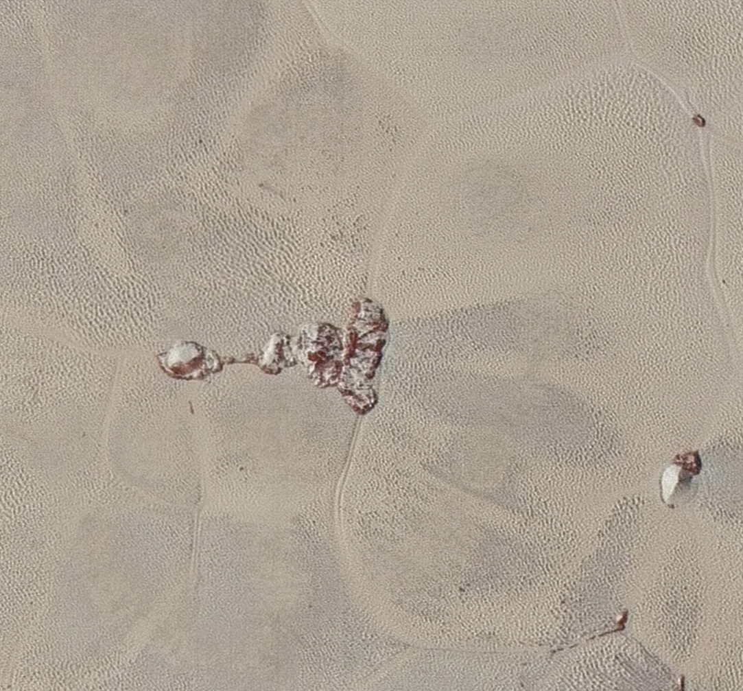
Beyond MVIC, additional new images taken by New Horizons’ narrow-angle Long Range Reconnaissance Imager (LORRI) during the July 14 were downlinked on Sept. 20.

They focus on the Sputnik Planum ice plains on the left side of the famous heart shaped Tombaugh Regio feature and are the highest resolution yet – as seen below. The team added color based on the global MVIC map shown above.

High-resolution images of Pluto taken by NASA’s New Horizons spacecraft just before closest approach on July 14, 2015, are the sharpest images to date of Pluto’s varied terrain—revealing details down to scales of 270 meters. In this 75-mile (120-kilometer) section of the taken from a larger, high-resolution mosaic, the textured surface of the plain surrounds two isolated ice mountains.  Credits: NASA/JHUAPL/SWRI
High-resolution images of Pluto taken by NASA’s New Horizons spacecraft just before closest approach on July 14, 2015, are the sharpest images to date of Pluto’s varied terrain—revealing details down to scales of 270 meters. In this 75-mile (120-kilometer) section of the taken from a larger, high-resolution mosaic, the textured surface of the plain surrounds two isolated ice mountains. Credits: NASA/JHUAPL/SWRI

Barely 5 or 6 percent of the 50 gigabits of data captured by New Horizons has been received by ground stations back on Earth.

“With these just-downlinked images and maps, we’ve turned a new page in the study of Pluto beginning to reveal the planet at high resolution in both color and composition,” added New Horizons Principal Investigator Alan Stern, of SwRI.

“I wish Pluto’s discoverer Clyde Tombaugh had lived to see this day.”

Stern says it will take about a year for all the data to get back. Thus bountiful new discoveries are on tap.

This new global mosaic view of Pluto was created from the latest high-resolution images to be downlinked from NASA’s New Horizons spacecraft and released on Sept. 11, 2015.   The images were taken as New Horizons flew past Pluto on July 14, 2015, from a distance of 50,000 miles (80,000 kilometers).  This mosaic was stitched from over two dozen raw images captured by the LORRI imager and colorized.  Right side mosaic comprises twelve highest resolution views of Tombaugh Regio heart shaped feature and shows objects as small as 0.5 miles (0.8 kilometers) in size.  Credits: NASA/Johns Hopkins University Applied Physics Laboratory/Southwest Research Institute/ Ken Kremer/kenkremer.com/Marco Di Lorenzo
This new global mosaic view of Pluto was created from the latest high-resolution images to be downlinked from NASA’s New Horizons spacecraft and released on Sept. 11, 2015. The images were taken as New Horizons flew past Pluto on July 14, 2015, from a distance of 50,000 miles (80,000 kilometers). This mosaic was stitched from over two dozen raw images captured by the LORRI imager and colorized. Right side mosaic comprises twelve highest resolution views of Tombaugh Regio heart shaped feature and shows objects as small as 0.5 miles (0.8 kilometers) in size. Credits: NASA/Johns Hopkins University Applied Physics Laboratory/Southwest Research Institute/ Ken Kremer/kenkremer.com/Marco Di Lorenzo

Stay tuned here for Ken’s continuing Earth and planetary science and human spaceflight news.

Ken Kremer

Just 15 minutes after its closest approach to Pluto on July 14, 2015, NASA's New Horizons spacecraft looked back toward the sun and captured this near-sunset view of the rugged, icy mountains and flat ice plains extending to Pluto's horizon - shown in this colorized rendition. The smooth expanse of the informally named icy plain Sputnik Planum (right) is flanked to the west (left) by rugged mountains up to 11,000 feet (3,500 meters) high, including the informally named Norgay Montes in the foreground and Hillary Montes on the skyline. To the right, east of Sputnik, rougher terrain is cut by apparent glaciers. The backlighting highlights more than a dozen layers of haze in Pluto’s tenuous but distended atmosphere. The image was taken from a distance of 11,000 miles (18,000 kilometers) to Pluto; the scene is 780 miles (1,250 kilometers) wide. Credit: NASA/Johns Hopkins University Applied Physics Laboratory/Southwest Research Institute. Colorized/Annotated: Marco Di Lorenzo/Ken Kremer/kenkremer.com
Just 15 minutes after its closest approach to Pluto on July 14, 2015, NASA’s New Horizons spacecraft looked back toward the sun and captured this near-sunset view of the rugged, icy mountains and flat ice plains extending to Pluto’s horizon – shown in this colorized rendition. The smooth expanse of the informally named icy plain Sputnik Planum (right) is flanked to the west (left) by rugged mountains up to 11,000 feet (3,500 meters) high, including the informally named Norgay Montes in the foreground and Hillary Montes on the skyline. To the right, east of Sputnik, rougher terrain is cut by apparent glaciers. The backlighting highlights more than a dozen layers of haze in Pluto’s tenuous but distended atmosphere. The image was taken from a distance of 11,000 miles (18,000 kilometers) to Pluto; the scene is 780 miles (1,250 kilometers) wide. Credit: NASA/Johns Hopkins University Applied Physics Laboratory/Southwest Research Institute. Colorized/Annotated: Marco Di Lorenzo/Ken Kremer/kenkremer.com