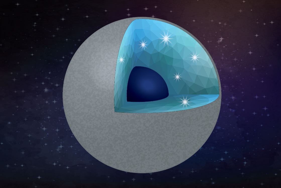
llustration of a carbon-rich planet with diamond and silica as main minerals. Water can convert a carbide planet into a diamond-rich planet. In the interior, the main minerals would be diamond and silica (a layer with crystals in the illustration). The core (dark blue) might be iron-carbon alloy. Credit: Shim/ASU/Vecteezy
Scientists are getting better at understanding exoplanets. We now know that they’re plentiful, and that they can even orbit dead white dwarf stars. Researchers are also getting better at understanding how they form, and what they’re made of.
A new study says that some carbon-rich exoplanets could be made of silica, and even diamonds, under the right circumstances.
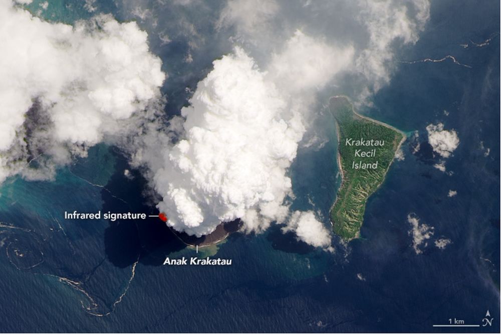
Plumes rise from Anak Krakatau on April 13th 2020 in this LandSat 8 OLI image. Image Credit: NASA Earth Observatory image by Lauren Dauphin, using Landsat data from the U.S. Geological Survey.
In between the Indonesian islands of Java and Sumatra lies the Sunda Strait. And in the Sunda Strait lies the much smaller island of Anak Krakatau, one of Earth’s active volcanoes. It’s erupted more than 50 times in the past 2,000 years, and now it’s doing it again.
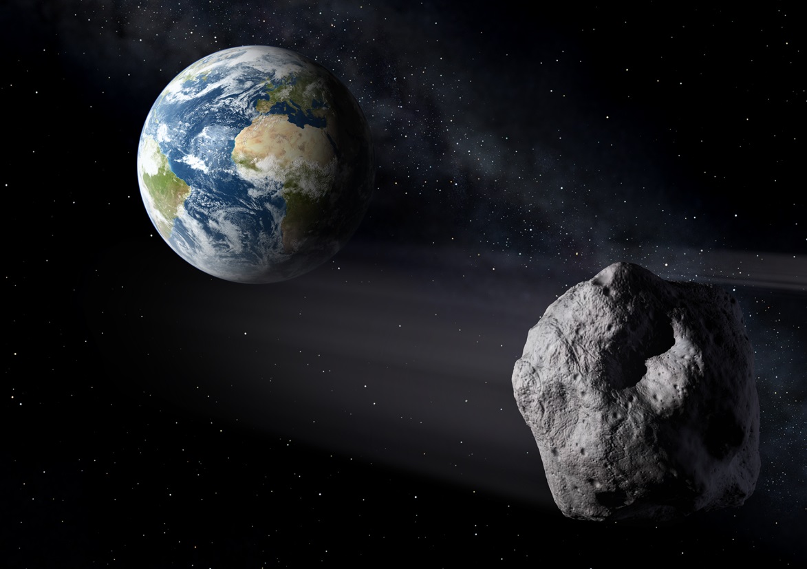
Mining asteroids might be necessary for humanity to expand into the Solar System. But what effect would asteroid mining have on the world's economy? Credit: ESA.
Plate tectonics have played a vital role in the geological evolution of our planet. In addition, many scientists believe that Earth’s geologically activity may have played an important role in the evolution of life – and could even be essential for a planet’s habitability. For this reason, scientists have long sought to determine how and when Earth’s surface changed from molten, viscous rock to a solid crust that is constantly resurfacing.
Artist's concept of Kepler-69c, a super-Earth-size planet in the habitable zone of a star like our sun, located about 2,700 light-years from Earth in the constellation Cygnus. Credit: NASA
When looking for potentially-habitable extra-solar planets, scientists are somewhat restricted by the fact that we know of only one planet where life exists (i.e. Earth). For this reason, scientists look for planets that are terrestrial (i.e. rocky), orbit within their star’s habitable zones, and show signs of biosignatures such as atmospheric carbon dioxide – which is essential to life as we know it.
This gas, which is the largely result of volcanic activity here on Earth, increases surface heat through the greenhouse effect and cycles between the subsurface and the atmosphere through natural processes. For this reason, scientists have long believed that plate tectonics are essential to habitability. However, according to a new study by a team from Pennsylvania State University, this may not be the case.
The study, titled “Carbon Cycling and Habitability of Earth-Sized Stagnant Lid Planets“, was recently published in the scientific journal Astrobiology. The study was conducted by Bradford J. Foley and Andrew J. Smye, two assistant professors from the department of geosciences at Pennsylvania State University.
The Earth’s Tectonic Plates. Credit: msnucleus.org
On Earth, volcanism is the result of plate tectonics and occurs where two plates collide. This causes subduction, where one plate is pushed beneath the other and deeper into the subsurface. This subduction changes the dense mantle into buoyant magma, which rises through the crust to the Earth’s surface and creates volcanoes. This process can also aid in carbon cycling by pushing carbon into the mantle.
Plate tectonics and volcanism are believe to have been central to the emergence of life here on Earth, as it ensured that our planet had sufficient heat to maintain liquid water on its surface. To test this theory, Professors Foley and Smye created models to determine how habitable an Earth-like planet would be without the presence of plate tectonics.
These models took into account the thermal evolution, crustal production and CO2 cycling to constrain the habitability of rocky, Earth-sized stagnant lid planets. These are planets where the crust consists of a single, giant spherical plate floating on mantle, rather than in separate pieces. Such planets are thought to be far more common than planets that experience plate tectonics, as no planets beyond Earth have been confirmed to have tectonic plates yet. As Prof. Foley explained in a Penn State News press release:
“Volcanism releases gases into the atmosphere, and then through weathering, carbon dioxide is pulled from the atmosphere and sequestered into surface rocks and sediment. Balancing those two processes keeps carbon dioxide at a certain level in the atmosphere, which is really important for whether the climate stays temperate and suitable for life.”
Map of the Earth showing fault lines (blue) and zones of volcanic activity (red). Credit: zmescience.com
Essentially, their models took into account how much heat a stagnant lid planet’s climate could retain based on the amount of heat and heat-producing elements present when the planet formed (aka. its initial heat budget). On Earth, these elements include uranium which produces thorium and heat when it decays, which then decays to produce potassium and heat.
After running hundreds of simulations, which varied the planet’s size and chemical composition, they found that stagnant lid planets would be able to maintain warm enough temperatures that liquid water could exist on their surfaces for billions of years. In extreme cases, they could sustain life-supporting temperatures for up to 4 billion years, which is almost the age of the Earth.
As Smye indicated, this is due in part to the fact that plate tectonics are not always necessary for volcanic activity:
“You still have volcanism on stagnant lid planets, but it’s much shorter lived than on planets with plate tectonics because there isn’t as much cycling. Volcanoes result in a succession of lava flows, which are buried like layers of a cake over time. Rocks and sediment heat up more the deeper they are buried.”
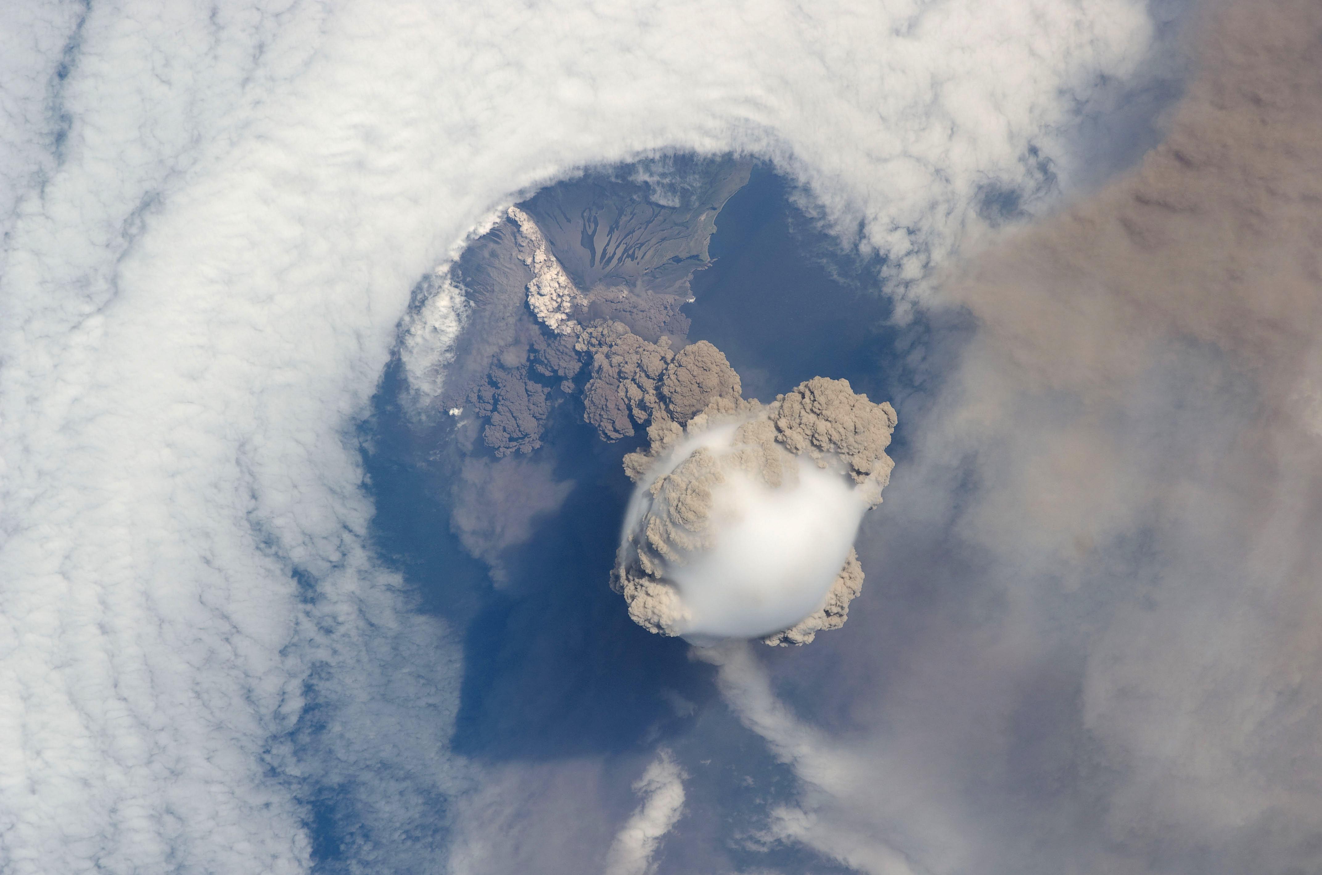
Image of the Sarychev volcano (in Russia’s Kuril Islands) caught during an early stage of eruption on June 12, 2009. Taken by astronauts aboard the International Space Station. Credit: NASA
The researchers also found that without plate tectonics, stagnant lid planets could still have enough heat and pressure to experience degassing, where carbon dioxide gas can escape from rocks and make its way to the surface. On Earth, Smye said, the same process occurs with water in subduction fault zones. This process increases based on the quantity of heat-producing elements present in the planet. As Foley explained:
“There’s a sweet spot range where a planet is releasing enough carbon dioxide to keep the planet from freezing over, but not so much that the weathering can’t pull carbon dioxide out of the atmosphere and keep the climate temperate.”
According to the researchers’ model, the presence and amount of heat-producing elements were far better indicators for a planet’s potential to sustain life. Based on their simulations, they found that the initial composition or size of a planet is very important for determining whether or not it will become habitable. Or as they put it, the potential habitability of a planet is determined at birth.
By demonstrating that stagnant lid planets could still support life, this study has the potential for greatly extending the range of what scientists consider to be potentially-habitable. When the James Webb Space Telescope (JWST) is deployed in 2021, examining the atmospheres of stagnant lid planets to determine the presence of biosignatures (like CO2) will be a major scientific objective.
Knowing that more of these worlds could sustain life is certainly good news for those who are hoping that we find evidence of extra-terrestrial life in our lifetimes.
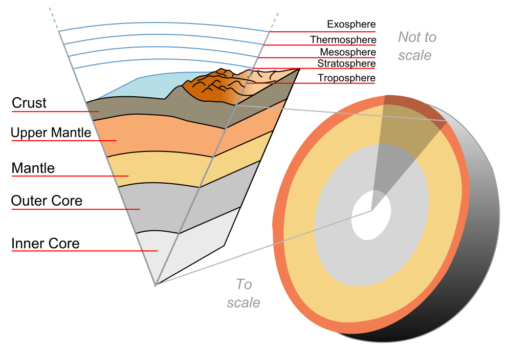
The Earth's layers, showing the Inner and Outer Core, the Mantle, and Crust. Credit: discovermagazine.com
As you may recall learning in geology class, the Earth is made up of distinct layers. The further one goes towards the center of the planet, the more intense the heat and pressure becomes. Luckily, for those of us living on the crust (the outermost layer, where all life lives) the temperature is relatively steady and pleasant.
In fact, one of the things that makes planet Earth habitable is the fact that the planet is close enough to our Sun to receive enough energy to stay warm. What’s more, its “surface temperatures” are warm enough to sustain liquid water, the key to life as we know it. But the temperature of Earth’s crust also varies considerably depending on where and when you are measuring it.
Earth’s Structure:
As a terrestrial planet, Earth is composed of silicate rocks and metals which are differentiated between a solid metal core, a molten outer core, and a silicate mantle and crust. The inner core has an estimated radius of 1,220 km, while the outer core extends beyond it to a radius of about 3,400 km.
The layers of the Earth, a differentiated planetary body. Credit: Wikipedia Commons/Surachit
Extending outwards from the core are the mantle and the crust. Earth’s mantle extends to a depth of 2,890 km beneath the surface, making it the thickest layer of Earth. This layer is composed of silicate rocks that are rich in iron and magnesium relative to the overlying crust. Although solid, the high temperatures within the mantle cause the silicate material to be sufficiently ductile that it can flow on very long timescales.
The upper layer of the mantle is divided into the lithospheric mantle (aka. the lithosphere) and the asthenosphere. The former consists of the crust and the cold, rigid, top part of the upper mantle (which the tectonic plates are composed of) while the asthenosphere is the relatively low-viscosity layer on which the lithosphere rides.
Earth’s Crust:
The crust is the absolute outermost layer of the Earth, which constitutes just 1% of the Earth’s total mass. The thickness of the crust varies depending on where the measurements are taken, ranging from 30 km thick where there are continents to just 5 km thick beneath the oceans.
The crust is composed of a variety of igneous, metamorphic and sedimentary rocks and is arranged in a series of tectonic plates. These plates float above the Earth’s mantle, and it’s believed that convection in the mantle causes the plates to be in constant motion.
Sometimes these plates collide, pull apart, or slide alongside each other; resulting in convergent boundaries, divergent boundaries, and transform boundaries. In the case of convergent boundaries, subduction zones are often the result, where the heavier plate slips under the lighter plate – forming a deep trench.
In the case of divergent boundaries, these are formed when tectonic plates pull apart, forming rift valleys on the seafloor. When this happens, magma wells up in the rift as the old crust pulls itself in opposite directions, where it is cooled by seawater to form new crust.
A transform boundary is formed when tectonic plates slide horizontally and parts get stuck at points of contact. Stress builds in these areas as the rest of the plates continue to move, which causes the rock to break or slip, suddenly lurching the plates forward and causing earthquakes. These areas of breakage or slippage are called faults.
Illustration of the Earth’s Tectonic Plates and the plate boundaries. Credit: msnucleus.org
Taken together, these three types of tectonic plate action are what is responsible for shaping the Earth’s crust and leading to periodic renewal of its surface over the course of millions of years.
Temperature Range:
The temperature of the Earth’s crust ranges considerably. At its outer edge, where it meets the atmosphere, the crust’s temperature is the same temperature as that of the air. So, it might be as hot as 35 °C in the desert and below freezing in Antarctica. On average, the surface of the Earth’s crust experiences temperatures of about 14°C.
However, the hottest temperature ever recorded was 70.7°C (159°F), which was taken in the Lut Desert of Iran as part of a global temperature survey conducted by scientists at NASA’s Earth Observatory. Meanwhile, the coldest temperature ever recorded on Earth was measured at the Soviet Vostok Station on the Antarctic Plateau – which reached an historic low of -89.2°C (-129°F) on July 21st, 1983.
That’s quite the range already. But consider the fact that the majority of the Earth’s crust lies beneath the oceans. Far from the Sun, temperatures can reach as low as 0-3° C (32-37.5° F) where the water reaches the crust. Still, a lot balmier than a cold night in Antarctica!
And as geologists have known for some time, if you dig down into the continental crust, temperatures will go up. For example, the deepest mine in the world is currently the TauTona gold mine in South Africa, measuring 3.9 km deep. At the bottom of the mine, temperatures reach a sweltering 55 °C, which requires that air conditioning be provided so that it’s comfortable for the miners to work all day.
So in the end, the temperature of Earth’s crust varies considerably. It’s average surface temperature which depends on whether it is being taken on dry land or beneath the sea. And depending on the location, seasons, and time of day, it can range from sweltering to freezing cold!
And yet, Earth’s crust remains the only place in the Solar System where temperatures are stable enough that life can continue to thrive on it. Add to that our viable atmosphere and protective magnetosphere, and we really should consider ourselves to be the lucky ones!
Sarychev volcano, (located in Russia's Kuril Islands, northeast of Japan) in an early stage of eruption on June 12, 2009. Credit: NASA
What if someone were to tell you that there’s a region in the world where roughly 90% of the world’s earthquakes occur. What if they were to tell you that this region is also home to over 75% of the world’s active and dormant volcanoes, and all but 3 of the world’s 25 largest eruptions in the last 11,700 years took place here.
Chances are, you’d think twice about buying real-estate there. But strangely enough, hundreds of millions of people live in this area, and some of the most densely-packed cities in the world have been built atop its shaky faults. We are talking about the Pacific Ring of Fire, a geologically and volcanically active region that stretches from one side of the Pacific to the other.
Definition:
Also known as the circum-Pacific belt, the “Ring of Fire” is a 40,000 km (25,000 mile) horseshoe-shaped basin that is associated with a nearly continuous series of oceanic trenches, volcanic arcs, and volcanic belts and/or plate movements. This ring accounts for 452 volcanoes (active and dormant), stretching from the southern tip of South America, up along the coast of North America, across the Bering Strait, down through Japan, and into New Zealand – with several active and dormant volcanoes in Antarctica closing the ring.
Tectonic Activity:
The Ring of Fire is the direct result of plate tectonics and the movement and collisions of lithospheric plates. These plates, which constitute the outer layer of the planet, are constantly in motion atop the mantle. Sometimes they collide, pull apart, or slide alongside each other; resulting in convergent boundaries, divergent boundaries, and transform boundaries.
The Pacific Ring of Fire, a string of volcanic regions extending from the South Pacific to South America. Credit: Public Domain
In the case of the former, subduction zones are often the result, where the heavier plate slips under the lighter plate – forming a deep trench. This subduction changes the dense mantle into buoyant magma, which rises through the crust to the Earth’s surface. Over millions of years, this rising magma creates a series of active volcanoes known as a volcanic arc.
These ocean trenches and volcanic arcs run parallel to one another. For instance, the Aleutian Islands in the U.S. state of Alaska run parallel to the Aleutian Trench. Both geographic features continue to form as the Pacific Plate subducts beneath the North American Plate. Meanwhile, the Andes Mountains of South America run parallel to the Peru-Chile Trench, created as the Nazca Plate subducts beneath the South American Plate.
In the case of divergent boundaries, these are formed when tectonic plates pull apart, forming rift valleys on the seafloor. When this happens, magma wells up in the rift as the old crust pulls itself in opposite directions, where it is cooled by seawater to form new crust. This upward movement and eventual cooling of this magma has created high ridges on the ocean floor over millions of years.
The East Pacific Rise is a site of major seafloor spreading in the Ring of Fire, located on the divergent boundary of the Pacific Plate and the Cocos Plate (west of Central America), the Nazca Plate (west of South America), and the Antarctic Plate. The largest known group of volcanoes on Earth is found underwater along the portion of the East Pacific Rise between the coasts of northern Chile and southern Peru.
The different type of tectonic plate boundaries. Credit: oceanexplorer.noaa.gov
A transform boundary is formed when tectonic plates slide horizontally and parts get stuck at points of contact. Stress builds in these areas as the rest of the plates continue to move, which causes the rock to break or slip, suddenly lurching the plates forward and causing earthquakes. These areas of breakage or slippage are called faults, and the majority of Earth’s faults can be found along transform boundaries in the Ring of Fire.
The San Andreas Fault, stretching along the central west coast of North America, is one of the most active faults on the Ring of Fire. It lies on the transform boundary between the North American Plate, which is moving south, and the Pacific Plate, which is moving north. Measuring about 1,287 kilometers (800 miles) long and 16 kilometers (10 miles) deep, the fault cuts through the western part of the U.S. state of California.
Plate Boundaries:
The eastern section of the Ring of Fire is the result of the Nazca Plate and the Cocos Plate being subducted beneath the westward moving South American Plate. Meanwhile, the Cocos Plate is being subducted beneath the Caribbean Plate, in Central America. A portion of the Pacific Plate along with the small Juan de Fuca Plate are being subducted beneath the North American Plate.
Along the northern portion, the northwestward-moving Pacific plate is being subducted beneath the Aleutian Islands arc. Farther west, the Pacific plate is being subducted along the Kamchatka Peninsula arcs on south past Japan.
The Earth’s Tectonic Plates. Credit: msnucleus.org
The southern portion is more complex, with a number of smaller tectonic plates in collision with the Pacific plate from the Mariana Islands, the Philippines, Bougainville, Tonga, and New Zealand. This portion excludes Australia, since it lies in the center of its tectonic plate.
Indonesia lies between the Ring of Fire along the northeastern islands adjacent to and including New Guinea and the Alpide belt along the south and west from Sumatra, Java, Bali, Flores, and Timor. The famous and very active San Andreas Fault zone of California is a transform fault which offsets a portion of the East Pacific Rise under southwestern United States and Mexico.
Volcanic Activity:
Most of the active volcanoes on The Ring of Fire are found on its western edge, from the Kamchatka Peninsula in Russia, through the islands of Japan and Southeast Asia, to New Zealand. Mount Ruapehu in New Zealand is one of the more active volcanoes in the Ring of Fire, with yearly minor eruptions, and major eruptions occurring about every 50 years.
Krakatau, perhaps better known as Krakatoa, is an island volcano in Indonesia. Krakatoa erupts less often than Mount Ruapehu, but much more spectacularly. Beneath Krakatoa, the denser Australian Plate is being subducted beneath the Eurasian Plate. An infamous eruption in 1883 destroyed the entire island, sending volcanic gas, volcanic ash, and rocks as high as 80 kilometers (50 miles) in the air. A new island volcano, Anak Krakatau, has been forming with minor eruptions ever since.
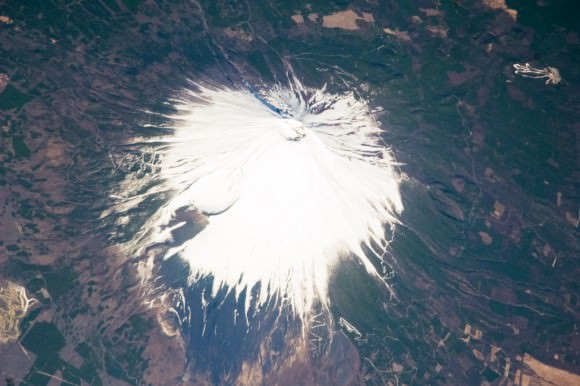
Mount Fuji, Japan, as seen from the ISS. Credit: NASA
Mount Fuji, Japan’s tallest and most famous mountain, is an active volcano in the Ring of Fire. Mount Fuji last erupted in 1707, but recent earthquake activity in eastern Japan may have put the volcano in a “critical state.” Mount Fuji sits at a “triple junction,” where three tectonic plates (the Amur Plate, Okhotsk Plate, and Philippine Plate) interact.
The Ring of Fire’s eastern half also has a number of active volcanic areas, including the Aleutian Islands, the Cascade Mountains in the western U.S., the Trans-Mexican Volcanic Belt, and the Andes Mountains. Mount St. Helens, in the U.S. state of Washington, is an active volcano in the Cascade Mountains.
Below Mount St. Helens, both the Juan de Fuca and Pacific plates are being subducted beneath the North American Plate. Its historic 1980 eruption lasted 9 hours and covered 11 U.S. states with tons of volcanic ash. The eruption caused the deaths of 57 people, over a billion dollars in property damage, and reduced hundreds of square miles to wasteland.
Popocatépetl is one of the most active and dangerous volcanoes in the Ring of Fire, with 15 recorded eruptions since 1519. The volcano lies on the Trans-Mexican Volcanic Belt, which is the result of the small Cocos Plate subducting beneath the North American Plate. Located close to the urban areas of Mexico City and Puebla, Popocatépetl poses a risk to the more than 20 million people that live close enough to be threatened by a destructive eruption.
Map of the Earth showing the relation between fault lines (blue) and zones of volcanic activity (red). Credit: zmescience.com
Earthquakes:
Scientists have known for some time that the majority of the seismic activity occurs along plate boundaries. Hence why roughly 90% of the world’s earthquakes – which is estimated to be around 500,000 a year, one-fifth of which are detectable – occur around the Pacific Rim, where multiple plate boundaries exist.
As a result, earthquakes are a regular occurrence in places like Japan, Indonesia and New Zealand in Asia and the South Pacific; Alaska, British Columbia, California and Mexico in North America; and El Salvador, Guatemala, Peru and Chile in Central and South America. Where fault lines run beneath the ocean, larger earthquakes in these regions also trigger tsunamis.
The most well-known tsumanis to take place in the Ring of Fire include the 2004 Indian Ocean earthquake and tsunami. This was the most devastating tsunami of its kind in modern times, killing around 230,000 people and laying waste to communities throughout Indonesia, Thailand, and Southern Asia.
In 2010, an earthquake triggered a tsunami which caused 4334 confirmed deaths and devastating several coastal towns in south-central Chile, including the port at Talcahuano. The earthquake also generated a blackout that affected 93 percent of the Chilean population.
In 2011, an earthquake off the Pacific coast of Tohoku led to a tsunami that struck Japan and led to 5,891 deaths, 6,152 injuries, and 2,584 people to be declared missing across twenty prefectures. The tsunami also caused meltdowns at three reactors in the Fukushima Daiichi Nuclear Power Plant complex.
The Ring of Fire is a crucial region for many reasons. It serves as one of the main boundary regions for the tectonic plates of over half of the globe. It also affects the lives of millions if not billions of people who live in these regions. For many of the people who live in the Pacific Ring of Fire, the reality of a volcanic eruption or earthquake is commonplace and a challenge they have come to deal with over time.
At the same time, the volcanic activity has also provided many valuable resources, such as rich farmland and the possibility of tapping geothermal activity for heating and electricity. As always, nature gives with one hand and takes with the other!
If you have enjoyed this article there are several others on Universe Today that you will find interesting. Here is one called 10 Interesting Facts About Volcanoes. There is also a great article about plate tectonics.
You can also find some good resources online. There is a companion site for the PBS program Savage Earth that talks about the Ring of Fire. You can also check out the USGS site to see a detailed map of the Pacific Ring of Fire and more detailed information about plate tectonics.
You can also listen to Astronomy Cast. Episode 141 talks about volcanoes.
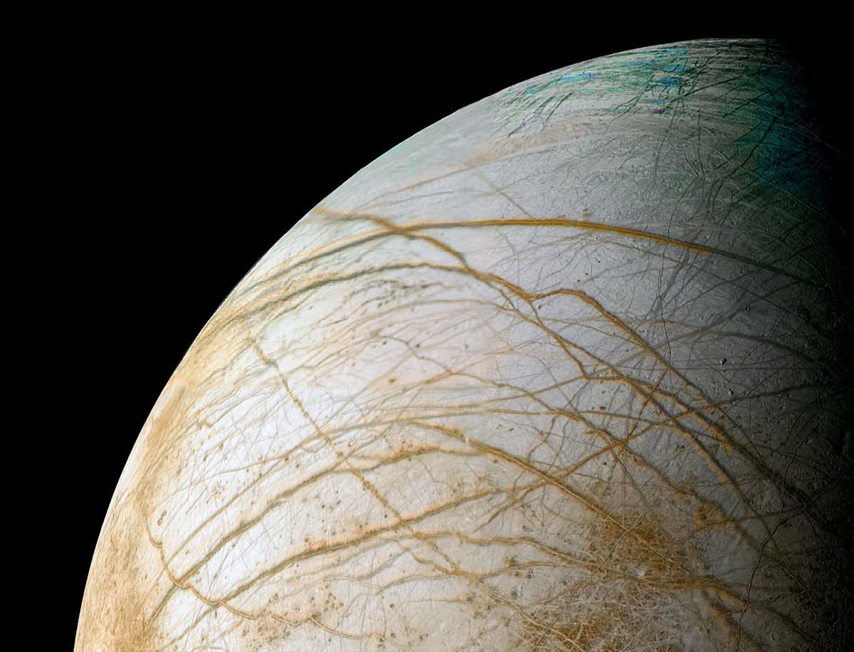
Reprocessed Galileo image of Europa's frozen surface by Ted Stryk (NASA/JPL/Ted Stryk)
Mysteries abound on icy Europa, that cold moon of Jupiter. Even years after the Galileo spacecraft finished its mission in the Jovian system, scientists are still trying to figure out the nature of the cracks on Europa’s surface. In an exciting find, one new paper suggests that at least part of the terrain could be due to plate tectonics.
If proven, this would be the first time that plate tectonics have been strongly suggested as a process working beyond Earth. On our home planet, scientists believe that this process, which happens as plates of Earth’s crust move, is responsible for creating mountains and volcanoes and earthquakes.
So why do they think this process is happening on Europa? The short answer is, weird terrain. For example, Scientists have seen evidence of what is called extension, which happens when the surface expands and then stuff from the layers below fills in the gap. But there were pieces of that understanding missing until now, the team says.
“We have been puzzled for years as to how all this new terrain could be formed, but we couldn’t figure out how it was accommodated,” stated Louise Prockter, a planetary scientist at Johns Hopkins University Applied Physics Laboratory who co-authored the study. “We finally think we’ve found the answer.”
An illustration of how subducting tectonic plates might work on Jupiter’s moon, Europa. This would bring the moon’s estimated 10-20 mile (20-30 kilometer) ice shell into the warmer insides of the moon. Credit: Noah Kroese, I.NK
Despite being pretty confident about the extension, scientists were unable to account for how all the new material arrived.
What the team did was try to model how Europa’s surface looked before how all the cracks appeared, and discovered that 7,700 square miles (20,000 square kilometers) couldn’t be accounted for in the high northern latitudes.
Looking more closely, they found ice volcanoes that they believe was on a surface plate, and missing mountains in what is thought to be a subduction zone. This suggests that stuff from the surface gets pushed underneath — not crushed into each other.
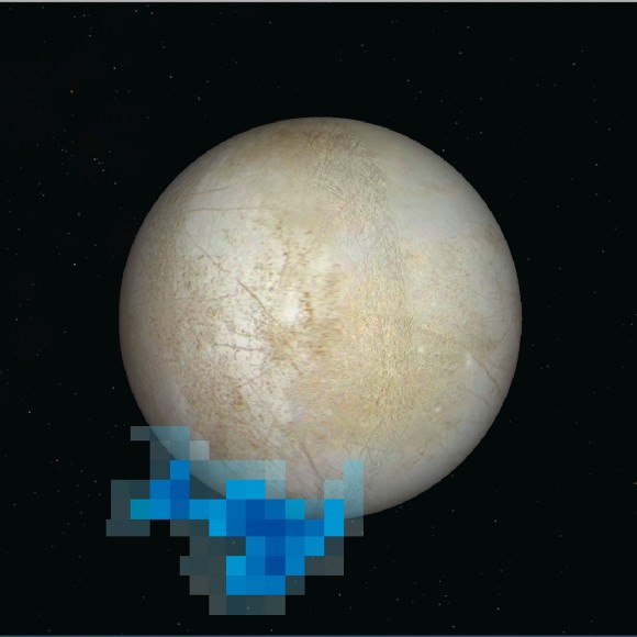
Rendering showing the location and size of water vapor plumes coming from Europa’s south pole. Credit: NASA/ESA/L. Roth/SWRI/University of Cologne
“Europa may be more Earth-like than we imagined, if it has a global plate tectonic system,” stated Simon Kattenhorn of the University of Idaho, Moscow, who led the study.
“Not only does this discovery make it one of the most geologically interesting bodies in the solar system, it also implies two-way communication between the exterior and interior — a way to move material from the surface into the ocean — a process which has significant implications for Europa’s potential as a habitable world.”
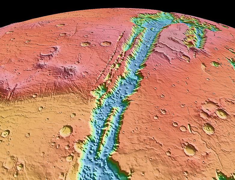
Valles Marineris NASA World Wind map Mars Credit NASA
Caption: Valles Marineris NASA World Wind Map Mars Credit: NASA
Until now, Earth was thought to be the only planet with plate tectonics. But a huge “crack” in Mars’ surface — the massive Valles Marinaris — shows evidence of the movement of huge crustal plates beneath the planet’s surface, meaning Mars may be showing the early stages of plate tectonics. This discovery can perhaps also shed light on how the plate tectonics process began here on Earth.
Valles Marineris is no ordinary crack on the Martian surface. It is the longest and deepest system of canyons in the Solar System. Stretching nearly 2,500 miles, it is nine times longer than Earth’s Grand Canyon.
An Yin, a planetary geologist and UCLA professor of Earth and space sciences, analyzed satellite images from THEMIS (Thermal Emission Imaging System), on board the Mars Odyssey spacecraft, and from the HIRISE (High Resolution Imaging Science Experiment) camera on NASA’s Mars Reconnaissance Orbiter.
“When I studied the satellite images from Mars, many of the features looked very much like fault systems I have seen in the Himalayas and Tibet, and in California as well, including the geomorphology,” he said.
The two plates that Yin calls Valles Marineris North and Valles Marineris South are moving approximately 93 miles horizontally relative to each other. By comparison, California’s San Andreas Fault, which is similarly over the intersection of two plates, has moved about twice as much, because Earth is about twice the size of Mars.
Yin believes Mars has no more than two plates whereas Earth has seven major plates and dozens of smaller ones. As Yin puts it “Earth has a very broken ‘egg shell,’ so its surface has many plates; Mars’ is slightly broken and may be on the way to becoming very broken, except its pace is very slow due to its small size and, thus, less thermal energy to drive it. This may be the reason Mars has fewer plates than on Earth.”
Mars also has several long, straight chains of volcanoes, including three that make up the Tharsis Montes, three large shield volcanoes which includes Olympus Mons, the tallest mountain in the Solar System at 22 km high. These volcanic chains may have formed from the motion of a plate sitting over a “hot spot” in the Martian mantle, in the same way the Hawaiian Islands are thought to have formed here on Earth. Yin also identified a steep cliff similar to cliffs in California’s Death Valley, which are generated by a fault, as well as a very smooth and flat side of a canyon wall which Yin says is also strong evidence of tectonic activity.
Yin also suggests that the fault is shifting occasionally, and may even produce “Marsquakes” every now and again. “I think the fault is probably still active, but not every day. It wakes up every once in a while, over a very long duration — perhaps every million years or more,” he said.
It is not known how far beneath the surface the plates on Mars are located. Yin admits “I don’t quite understand why the plates are moving with such a large magnitude or what the rate of movement is; maybe Mars has a different form of plate tectonics,” Yin said. “The rate is much slower than on Earth.”
“Mars is at a primitive stage of plate tectonics,” Yin added. “It gives us a glimpse of how the early Earth may have looked and may help us understand how plate tectonics began on Earth.”
Yin’s study was published in the August issue of the journal Lithosphere and he also plans to publish a follow-up paper hoping to shed more light on plate tectonics on both Mars and Earth.
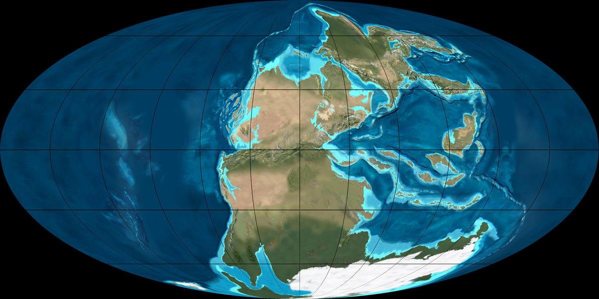
Continents might be necessary for life, especially complex life. This image shows super-continent Pangaea during the Permian period (300 - 250 million years ago). Credit: NAU Geology/Ron Blakey
So, you are curious about what is Pangaea? It was the supercontinent that existed 250 million years ago during the Paleozoic and Mesozoic eras. During the ensuing millenia, plate tectonics slowly moved each continent to its current position on the planet. Each continent is still slowly moving across the face of our world.
The breaking up and formation of supercontinents appears to have happened several times over Earth’s history with Pangaea being one among many. The next-to-last one, Pannotia, formed about 600 million years ago during the Proterozoic eon. Pannotia included large amounts of land near the poles and only a relatively small strip near the equator connecting the polar masses.
60 million years after its formation Pannotia broke up, giving rise to the continents of Laurentia, Baltica, and Gondwana. Laurentia would eventually become a large portion of North America, the microcontinent of Avalonia(a small portion of Gondwana) would become the northeastern United States, Nova Scotia, and England. All of these came together at the end of the Ordovician.
While this was happening, Gondwana drifted slowly towards the South Pole. These were the early steps in the formation of Pangaea. The next step was the collision of Gondwana with the other land mass. Southern Europe broke free of Gondwana. By late Silurian time, North and South China rifted away from Gondwana and started to head northward across the shrinking Proto-Tethys Ocean.
Movement continued slowly until the land masses drifted until their current positions. The list of oceans and microcontinents is too long to include in this article. We have many articles about this full process here on Universe Today. The evidence for Pangaea lies in the fossil records from the period. It includes the presence of similar and identical species on continents that are now great distances apart.
Additional evidence for Pangaea is found in the geology of adjacent continents, including matching geological trends between the eastern coast of South America and western Africa. The polar ice cap of the Carboniferous Period covered the southern end of Pangaea. Glacial deposits of the same age and structure are found on many separate continents which would have been together in the continent of Pangaea.
We know that the existence of supercontinents has been proven. We know that they have existed at different times in the Earth’s history. Also, we know that the tectonic plates are still moving. Is it possible that there will be another supercontinent someday in the distant future.
We have written many articles about Pangaea for Universe Today. Here’s an article about the Continental Drift Theory, and here’s an article about the continental plates.
In Plate Tectonic Theory, the lithosphere is broken into tectonic plates, which undergo some large scale motions. The boundary regions between plates are aptly called plate boundaries. Based upon their motions with respect to one another, these plate boundaries are of three kinds: divergent, convergent, and transform.
Divergent Boundaries:
Divergent boundaries are those that move away from one another. When they separate, they form what is known as a rift. As the gap between the two plates widen, the underlying layer may be soft enough for molten lava underneath to push its way upward. This upward push results in the formation of volcanic islands. Molten lava that succeeds in breaking free eventually cools and forms part of the ocean floor.
Some formations due to divergent plate boundaries are the Mid-Atlantic Ridge and the Gakkel Ridge. On land, you have Lake Baikal in Siberia and Lake Tanganyika in East Africa.
Convergent Boundaries:
Convergent boundaries are those that move towards one another. When they collide, subduction usually takes place. That is, the denser plate gets subducted or goes underneath the less dense one. Sometimes, the plate boundaries also experience buckling. Convergent boundaries are responsible for producing the deepest and tallest structures on Earth.
Among those that have formed due to convergent plate boundaries are K2 and Mount Everest, the tallest peaks in the world. They formed when the Indian plate got subducted underneath the Eurasian plate. Another extreme formation due to the convergent boundary is the Mariana Trench, the deepest region on Earth.
Transform Boundaries:
Transform boundaries are those that slide alongside one another. Lest you imagine a slippery, sliding motion, take note that the surfaces involved are exposed to huge amounts of stress and strain and are momentarily held in place. As a result, when the two plates finally succeed in moving with respect to one another, huge amounts of energy are released. This causes earthquakes.
The San Andreas fault in North America is perhaps the most popular transform boundary. Transform boundary is also known as transform fault or conservative plate boundary.
Movements of the plates are usually just a few centimeters per year. However, due to the huge masses and forces involved, they typically result in earthquakes and volcanic eruptions. If the interactions between plate boundaries involve only a few centimeters per year, you could just imagine the great expanse of time it had to take before the land formations we see today came into being.
You can read more about plate boundaries here in Universe Today. Here are the links: