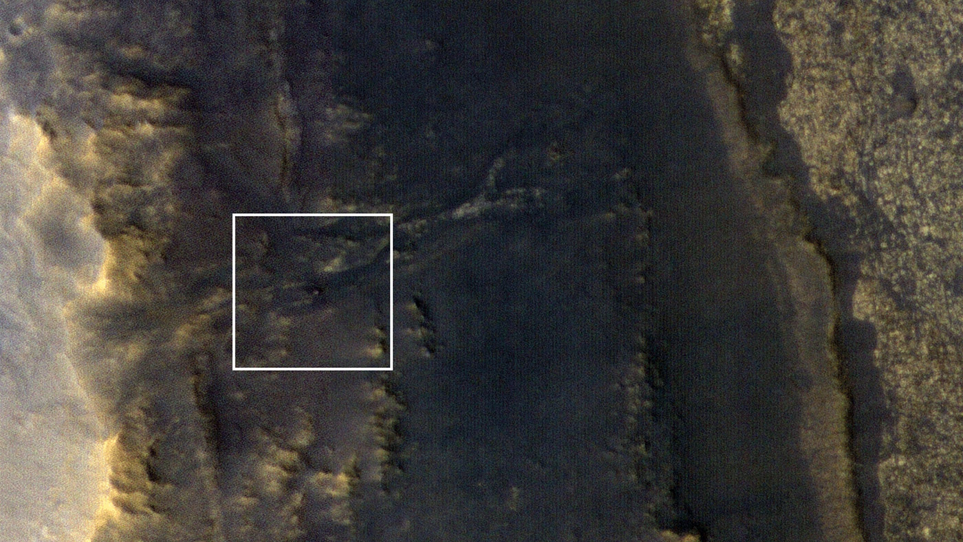
NASA's Opportunity rover appears as a blip in the center of this square. This image taken by HiRISE, a high-resolution camera onboard NASA's Mars Reconnaissance Orbiter, shows the dust storm over Perseverance Valley has substantially cleared. Image Credit: NASA/JPL-Caltech/Univ. of Arizona
A new image produced by the High-Resolution Imaging Science Experiment (HiRISE) aboard NASA’s Mars Reconnaissance Orbiter (MRO) has located the Opportunity rover on Mars. As expected, the rover was spotted on the slopes of the Perseverance Valley, where it went into hibernation mode about 100 days ago when the planet-covering dust storm darkened skies above the region.
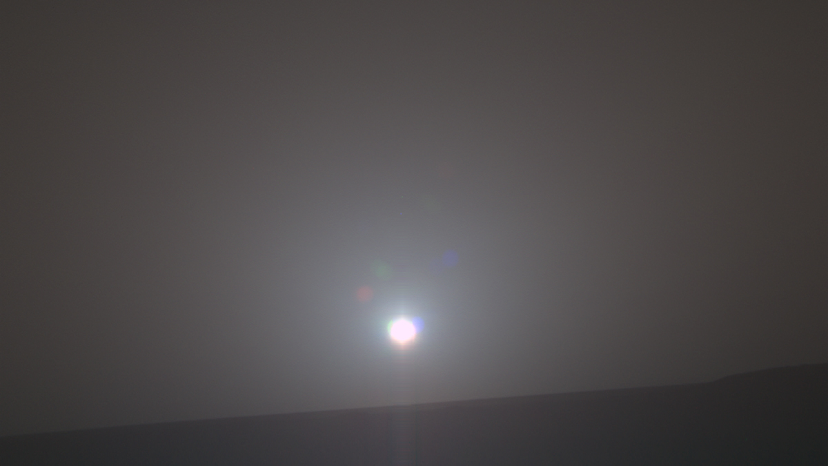
NASA's Mars Exploration Rover Opportunity recorded the dawn of the rover's 4,999th Martian day, or sol, with its Panoramic Camera (Pancam) on Feb. 15, 2018, yielding this processed, approximately true-color scene. Credits: NASA/JPL-Caltech/Cornell/Arizona State Univ./Texas A&M
It’s been a time of milestones for Mars rovers lately! Last month (on January 26th, 2018), NASA announced that the Curiosity rover had spent a total of 2,000 days on Mars, which works out to 5 years, 5 months and 21 days. This was especially impressive considering that the rover was only intended to function on the Martian surface for 687 days (a little under two years).
But when it comes to longevity, nothing has the Opportunity rover beat! Unlike Curiosity, which relied on a Multi-Mission Radioisotope Thermoelectric Generator (MMRTG) for power, the solar-powered Opportunity recently witnessed its five-thousandth sunrise on Mars. This means that the rover has remained in continuous operation for 5000 sols, which works out to 5137.46 Earth days.
This five-thousandth sunrise began on Friday, Feb. 16th, 2018 – roughly 14 Earth years (and 7.48 Martian years) after the rover first landed. From its position on the western rim of the Endeavour Crater, the sunrise appeared over the basin’s eastern rim, about 22 km (14 mi) away. This location, one-third of the way down “Perseverance Valley”, is more than 45 km (28 mi) from Opportunity’s original landing site.
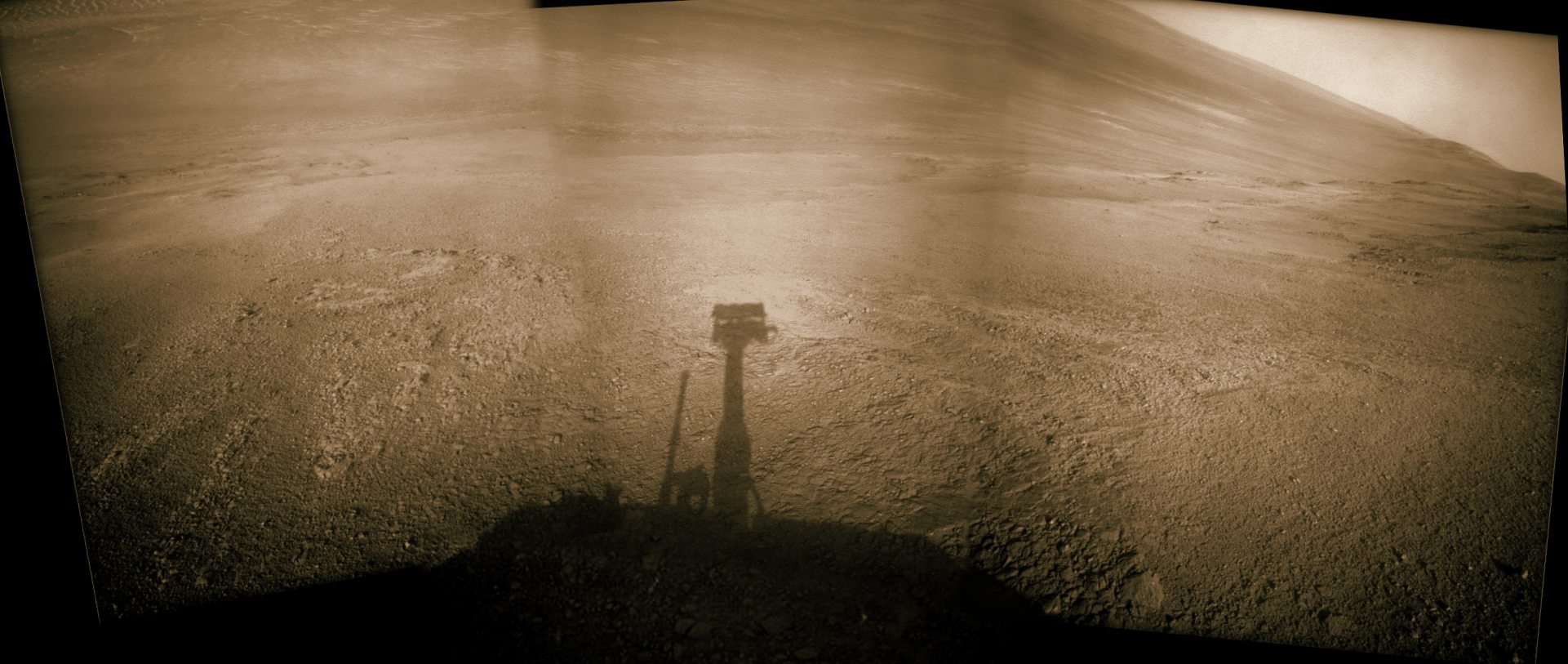
Mosaic view looking down from inside the upper end of “Perseverance Valley” on the inner slope of Endeavour Crater’s western rim. Credit: NASA/JPL/Cornell/Marco Di Lorenzo/Ken Kremer/kenkremer.com
This is especially impressive when you consider that the original science mission was only meant to last 90 sols (92.47 Earth days) and NASA did not expect the rover to survive its first Martian winter. And yet, the rover has not only survived all this time, it continues to send back scientific discoveries from the Red Planet. As John Callas, the Opportunity Project Manager at NASA’s Jet Propulsion Laboratory, explained in a NASA press release:
“Five thousand sols after the start of our 90-sol mission, this amazing rover is still showing us surprises on Mars… We’ve reached lots of milestones, and this is one more, but more important than the numbers are the exploration and the scientific discoveries.”
For instance, the rover has provided us with 225,000 images since its arrival, and revealed that ancient Mars was once home to extensive groundwater and surface water. Beginning in 2008, it began working its way across the Endeavour Crater in order to get a glimpse deeper into Mars’ past. By 2011, it had reached the crater’s edge and confirmed that mineral-rich water once flowed through the area.
At present, researchers are using Opportunity to investigate the processes that shaped Perseverance Valley, an area that descends down the slope of the western rim of Endeavour Crater. Here too, Opportunity has learned some fascinating things about the Red Planet. For instance, the rover has conducted observations of possible “rock stripes” in the valley, which could be indicative of its valley’s origin.
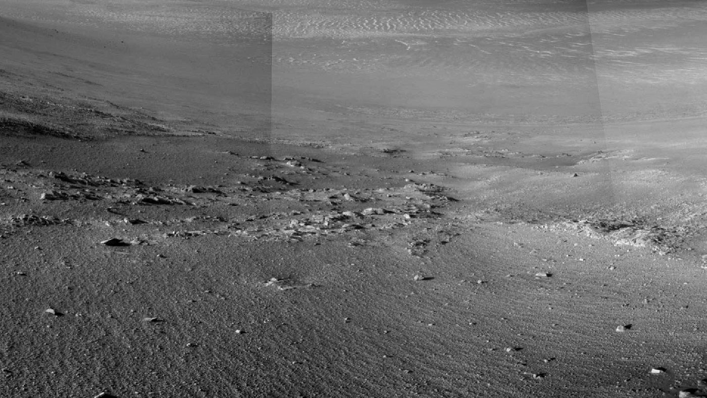
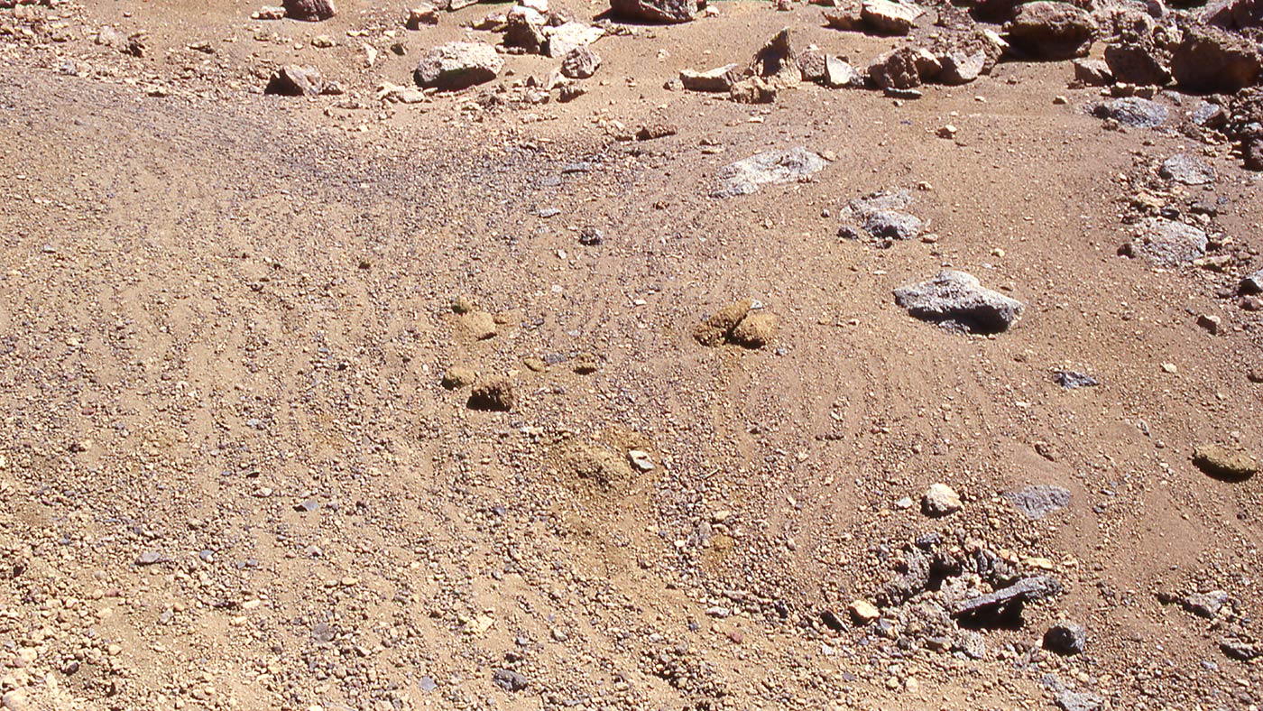
Textured rows on the ground in this portion of “Perseverance Valley” are under investigation by NASA’s Mars Exploration Rover Opportunity. Credits: NASA/JPL-Caltech
These stripes are of interest to scientists because of the way they resemble rock stripes that appear on mountain slopes here on Earth, which are the result of repeated cycles of freezing and thawing on wet soil. On Mauna Kea, for example, soil freezes every night, but is often dry due to the extreme elevation. This causes soils that have high concentrations of silt, sand and gravel to expand, pushing the larger particles up.
These particles then form stripes as they fall downhill, or are moved by wind or rainwater, and cause the ground to expand less in this space. This process repeats itself over and over, creating a pattern that leads to distinct stripes. As Opportunity observed, there are slopes within the Perseverance Valley where soil and gravel particles appear to have formed into rows that run parallel to the slope, alternating between rows that have more and less gravel.
In the case of the Perseverance Valley’s stripes, scientists are not sure how they formed, but think they could be the result of water, wind, downhill transport, other processes, or a combination thereof. Another theory posits that features like these could be the result of changes in Mars tilt (obliquity) which happen over the course of hundreds of thousands of years.
“One possible explanation of these stripes is that they are relics from a time of greater obliquity when snow packs on the rim seasonally melted enough to moisten the soil, and then freeze-thaw cycles organized the small rocks into stripes. Gravitational downhill movement may be diffusing them so they don’t look as crisp as when they were fresh.”
Stone stripes on the side of a volcanic cone on Mauna Kea, Hawaii, which are made of small rock fragments that are aligned downhill. These are formed when freeze-thaw cycles lift them out of the finer-grained regolith and move them to the sides, forming stone stripes. Credits: Washington University in St. Louis/NASA
Having the chance to investigate these features is therefore quite the treat for the Opportunity science team. “Perseverance Valley is a special place, like having a new mission again after all these years.” said Arvidson. “We already knew it was unlike any place any Mars rover has seen before, even if we don’t yet know how it formed, and now we’re seeing surfaces that look like stone stripes. It’s mysterious. It’s exciting. I think the set of observations we’ll get will enable us to understand it.”
Given the state of the Martian surface, it is a safe bet that wind is largely responsible for the rock stripes observed in Perseverance Valley. In this respect, they would be caused by sand blown uphill from the crater floor that sorts larger particles into rows parallel to the slope. As Robert Sullivan, an Opportunity science-team member of Cornell University, explained:
“Debris from relatively fresh impact craters is scattered over the surface of the area, complicating assessment of effects of wind. I don’t know what these stripes are, and I don’t think anyone else knows for sure what they are, so we’re entertaining multiple hypotheses and gathering more data to figure it out.”
Despite being in service for a little over 14 years, and suffering its share of setbacks, Opportunity is once again in a position to reveal things about Mars’ past and how it evolved to become what it is today. Never let it be said that an old rover can’t reveal new secrets! If there’s one thing Opportunity has proven during its long history of service on Mars, it is that the underdog can make some of the greatest contributions.
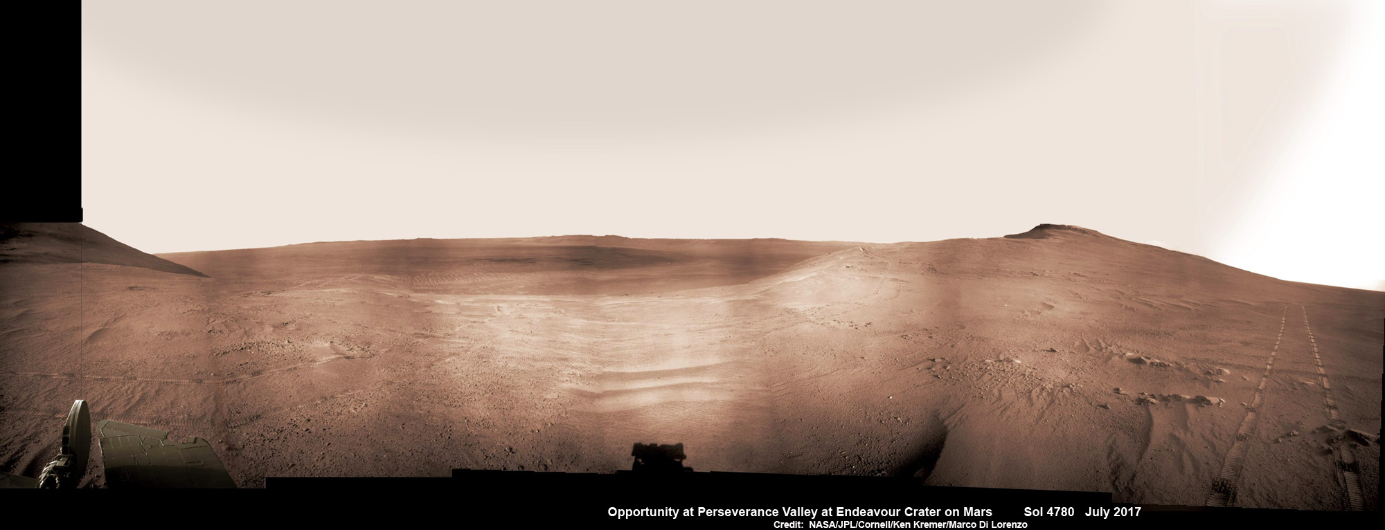
Historic 1st descent down Martian gully. Panoramic view looking down Perseverance Valley after entry at top was acquired by NASA’s Opportunity rover scanning from north to south. It shows numerous wheel tracks at left, center and right as rover conducted walkabout tour prior to starting historic first decent down a Martian gully - possibly carved by water - and looks into the interior of Endeavour crater. Perseverance Valley terminates down near the crater floor in the center of the panorama. The far rim of Endeavour crater is seen in the distance, beyond the dark floor. Rover mast shadow at center and deck at left. This navcam camera photo mosaic was assembled by Ken Kremer and Marco Di Lorenzo from raw images taken on Sol 4780 (5 July 2017) and colorized. Credit: NASA/JPL/Cornell/Ken Kremer/kenkremer.com/Marco Di Lorenzo
Historic 1st descent down Martian gully. Panoramic view looking down Perseverance Valley after entry at top was acquired by NASA’s Opportunity rover scanning from north to south. It shows numerous wheel tracks at left, center and right as rover conducted walkabout tour prior to starting historic first decent down a Martian gully – possibly carved by water – and looks into the interior of Endeavour crater. Perseverance Valley terminates down near the crater floor in the center of the panorama. The far rim of Endeavour crater is seen in the distance, beyond the dark floor. Rover mast shadow at center and deck at left. This navcam camera photo mosaic was assembled by Ken Kremer and Marco Di Lorenzo from raw images taken on Sol 4780 (5 July 2017) and colorized. Credit: NASA/JPL/Cornell/Ken Kremer/kenkremer.com/Marco Di Lorenzo
From the precipice of “Perseverance Valley” NASA’s teenaged Red Planet robot Opportunity has begun the historic first ever descent of an ancient Martian gully – that’s simultaneously visually and scientifically “tantalizing” – on an expedition to discern ‘How was it carved?’; by water or other means, Jim Green, NASA’s Planetary Sciences Chief tells Universe Today.
Since water is an indispensable ingredient for life as we know it, the ‘opportunity’ for Opportunity to study a “possibly water-cut” gully on Mars for the first time since they were discovered over four decades ago by NASA orbiters offers a potential scientific bonanza.
“Gullies on Mars have always been of intense interest since first observed by our orbiters,” Jim Green, NASA’s Planetary Sciences Chief explained to Universe Today.
“How were they carved? muses Green. “Water is a natural explanation but this is another planet. Now we have a chance to find out for real!”
Their origin and nature has been intensely debated by researchers for decades. But until now the ability to gather real ‘ground truth’ science by robotic or human explorers has remained elusive.
“This will be the first time we will acquire ground truth on a gully system that just might be formed by fluvial processes,” Ray Arvidson, Opportunity Deputy Principal Investigator of Washington University in St. Louis, told Universe Today.
“Perseverance Valley” is located along the eroded western rim of gigantic Endeavour crater – as illustrated by our exclusive photo mosaics herein created by the imaging team of Ken Kremer and Marco Di Lorenzo.
After arriving at the upper entryway to “Perseverance Valley” the six wheeled rover drove back and forth to gather high resolution imagery of the inner slope for engineers to create a 3D elevation map and plot a safe driving path down – as illustrated in our lead mosaic showing the valley and extensive wheel tracks at left, center and right.
Having just this week notched an astounding 4800 Sols roving the Red Planet, NASA’s resilient Opportunity rover has started driving down from the top of “Perseverance Valley” from the spillway overlooking the upper end of the ancient fluid-carved Martian valley into the unimaginably vast eeriness of alien Endeavour crater.
Water, ice or wind may have flowed over the crater rim and into the crater from the spillway.
“It is a tantalizing scene,” said Opportunity Deputy Principal Investigator Ray Arvidson of Washington University in St. Louis, in a statement. “You can see what appear to be channels lined by boulders, and the putative spillway at the top of Perseverance Valley. We have not ruled out any of the possibilities of water, ice or wind being responsible.”
Toward the right side of this scene is a broad notch in the crest of the western rim of Endeavour Crater. Wheel tracks in that area were left by NASA’s Mars Exploration Rover Opportunity as it observed “Perseverance Valley” from above in the spring of 2017. The valley is a major destination for the rover’s extended mission. It descends out of sight on the inner slope of the rim, extending down and eastward from that notch. The component pancam images for this view from a position outside the crater were taken during the span of June 7 to June 19, 2017, sols 4753 to 4765. Credit: NASA/JPL-Caltech/Cornell/Arizona State Univ.
“With the latest drive on sol 4782, Opportunity began the long drive down the floor of Perseverance Valley here on Endeavour crater, says Larry Crumpler, a rover science team member from the New Mexico Museum of Natural History & Science.
“This is rather historic in that it represents the first time that a rover has driven down an apparent water-cut valley on Mars. Over the next few months Opportunity will explore the floor and sides of the valley for evidence of the scale and timing of the fluvial activity, if that is what is represents.”
This mosaic view looks down from inside the upper end of “Perseverance Valley” on the inner slope of Endeavour Crater’s western rim after Opportunity started driving down the Martian gully. The scene behind the shadow of the rover’s mast shows Perseverance Valley descending to the floor of Endeavour Crater. This navcam camera photo mosaic was assembled from raw images taken on Sol 4782 (7 July 2017) and colorized. Credit: NASA/JPL/Cornell/Marco Di Lorenzo/Ken Kremer/kenkremer.com
NASA’s unbelievably long lived Martian robot reached a “spillway” at the top of “Perseverance Valley” in May after driving southwards for weeks from the prior science campaign at a crater rim segment called “Cape Tribulation.”
“Investigations in the coming weeks will “endeavor” to determine whether this valley was eroded by water or some other dry process like debris flows,” explains Crumpler.
“It certainly looks like a water cut valley. But looks aren’t good enough. We need additional evidence to test that idea.”
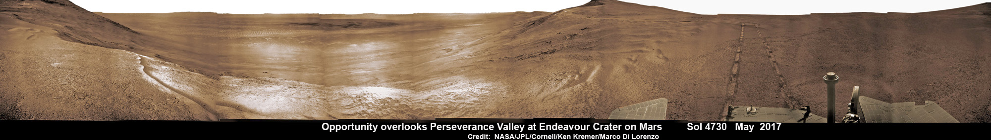
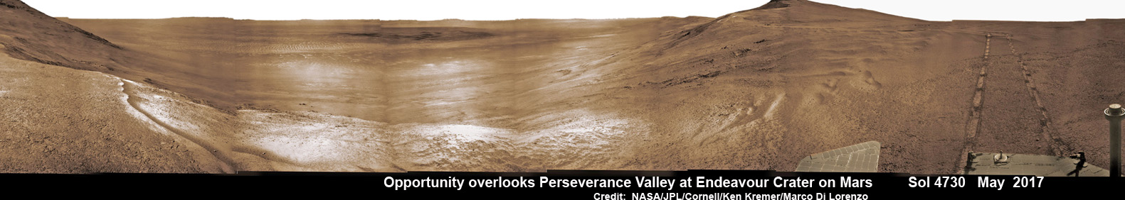
NASA’s Opportunity rover acquired this Martian panoramic view from a promontory that overlooks Perseverance Valley below – scanning from north to south. It is centered on due East and into the interior of Endeavour crater. Perseverance Valley descends from the right and terminates down near the crater floor in the center of the panorama. The far rim of Endeavour crater is seen in the distance, beyond the dark floor. Rover deck and wheel tracks at right. This navcam camera photo mosaic was assembled from raw images taken on Sol 4730 (14 May 2017) and colorized. Credit: NASA/JPL/Cornell/Ken Kremer/kenkremer.com/Marco Di Lorenzo
The valley slices downward from the crest line through the rim from west to east at a breathtaking slope of about 15 to 17 degrees – and measures about two football fields in length!
Huge Endeavour crater spans some 22 kilometers (14 miles) in diameter on the Red Planet. Perseverance Valley slices eastwards at approximately the 8 o’clock position of the circular shaped crater. It sits just north of a rim segment called “Cape Byron.”
Why go and explore the gully at Perseverance Valley?
“Opportunity will traverse to the head of the gully system [at Perseverance] and head downhill into one or more of the gullies to characterize the morphology and search for evidence of deposits,” Arvidson elaborated to Universe Today.
“Hopefully test among dry mass movements, debris flow, and fluvial processes for gully formation. The importance is that this will be the first time we will acquire ground truth on a gully system that just might be formed by fluvial processes. Will search for cross bedding, gravel beds, fining or coarsening upward sequences, etc., to test among hypotheses.”
Exploring the ancient valley is the main science destination of the current two-year extended mission (EM #10) for the teenaged robot, that officially began Oct. 1, 2016. It’s just the latest in a series of extensions going back to the end of Opportunity’s prime mission in April 2004.
Before starting the gully descent, Opportunity conducted a walkabout at the top of the Perseverance Valley in the spillway to learn more about the region before driving down.
“The walkabout is designed to look at what’s just above Perseverance Valley,” said Opportunity Deputy Principal Investigator Ray Arvidson of Washington University in St. Louis, in a statwemwent. “We see a pattern of striations running east-west outside the crest of the rim.”
“We want to determine whether these are in-place rocks or transported rocks,” Arvidson said. “One possibility is that this site was the end of a catchment where a lake was perched against the outside of the crater rim. A flood might have brought in the rocks, breached the rim and overflowed into the crater, carving the valley down the inner side of the rim. Another possibility is that the area was fractured by the impact that created Endeavour Crater, then rock dikes filled the fractures, and we’re seeing effects of wind erosion on those filled fractures.”
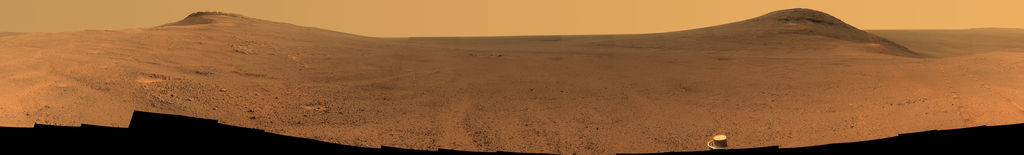
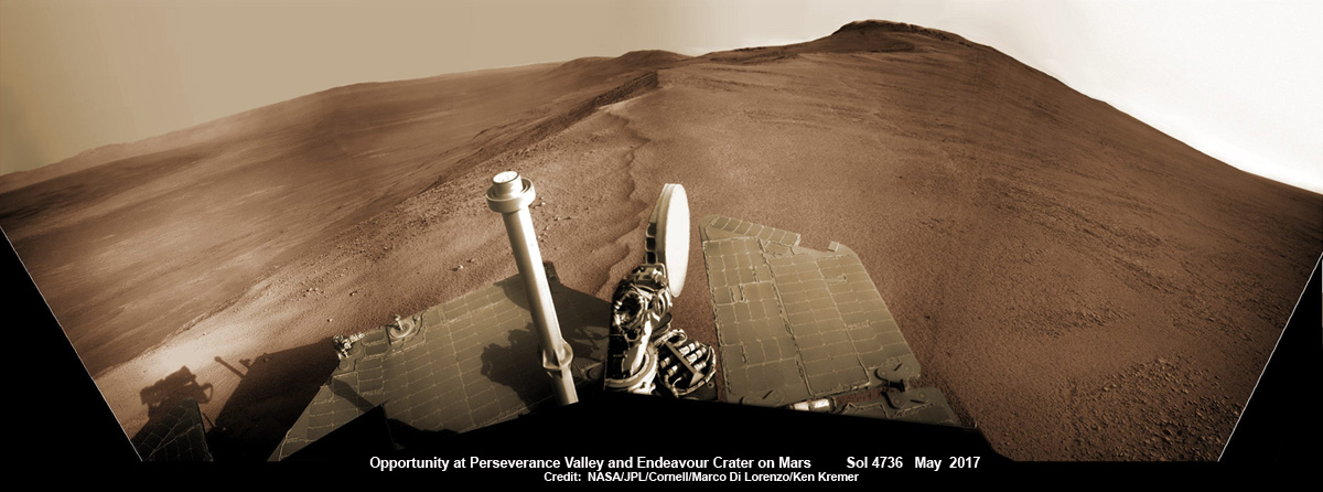
Opportunity rover looks south from the top of Perseverance Valley along the rim of Endeavour Crater on Mars in this partial self portrait including the rover deck and solar panels. Perseverance Valley descends from the right and terminates down near the crater floor. This navcam camera photo mosaic was assembled from raw images taken on Sol 4736 (20 May 2017) and colorized. Credit: NASA/JPL/Cornell/Marco Di Lorenzo/Ken Kremer/kenkremer.com
Having begun the long awaited gully descent, further movements are temporarily on hold since the start of the solar conjunction period which blocks communications between Mars and Earth for about the next two weeks, since Mars is directly behind the sun.
In the meantime, Opportunity will still collect very useful panoramic images and science data while standing still.
The solar conjunction moratorium on commanding extends from July 22 to Aug. 1, 2017.
As of today, July 27, 2017, long lived Opportunity has survived over 4800 Sols (or Martian days) roving the harsh environment of the Red Planet.
Opportunity has taken over 221,625 images and traversed over 27.95 miles (44.97 kilometers.- more than a marathon.
See our updated route map below. It shows the context of the rovers over 13 year long traverse spanning more than the 26 mile distance of a Marathon runners race.
The rover surpassed the 27 mile mark milestone on November 6, 2016 (Sol 4546) and will soon surpass the 28 mile mark.
As of Sol 4793 (July 18, 2017) the power output from solar array energy production is currently 332 watt-hours with an atmospheric opacity (Tau) of 0.774 and a solar array dust factor of 0.534, before heading into another southern hemisphere Martian winter later in 2017. It will count as Opportunity’s 8th winter on Mars.
Meanwhile Opportunity’s younger sister rover Curiosity traverses up the lower sedimentary layers at the base of Mount Sharp.
And NASA continues building the next two robotic missions due to touch down in 2018 and 2020.
NASA as well is focusing its human spaceflight efforts on sending humans on a ‘Journey to Mars’ in the 2030s with the Space Launch System (SLS) mega rocket and Orion deep space crew capsule.
Stay tuned here for Ken’s continuing Earth and planetary science and human spaceflight news.
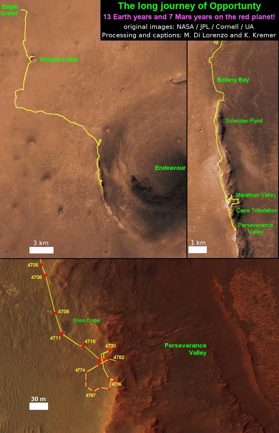
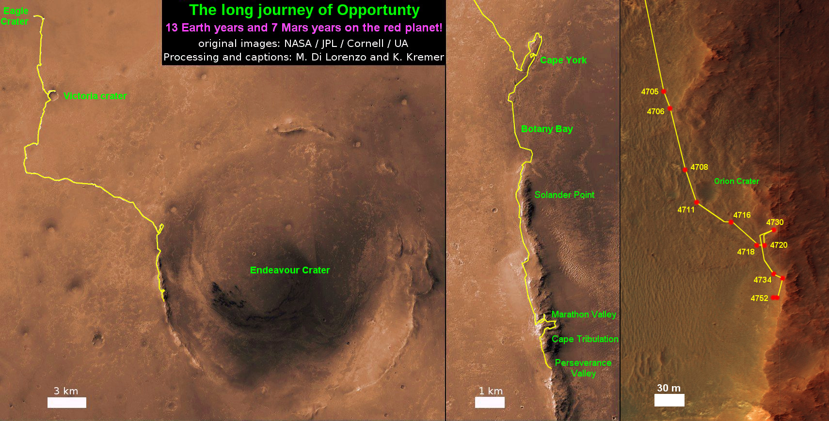
13 Year Traverse Map for NASA’s Opportunity rover from 2004 to 2017. This map shows the entire 43 kilometer (27 mi) path the rover has driven on the Red Planet during over 13 years and more than a marathon runners distance for over 4782 Sols, or Martian days, since landing inside Eagle Crater on Jan 24, 2004 – to current location at the western rim of Endeavour Crater. After studying Spirit Mound and ascending back uphill the rover has reached her next destination in May 2017- the Martian water carved gully at Perseverance Valley near Orion crater. Rover surpassed Marathon distance on Sol 3968 after reaching 11th Martian anniversary on Sol 3911. Opportunity discovered clay minerals at Esperance – indicative of a habitable zone – and searched for more at Marathon Valley. Credit: NASA/JPL/Cornell/ASU/Marco Di Lorenzo/Ken Kremer/kenkremer.com
Opportunity rover looks south from the top of Perseverance Valley along the rim of Endeavour Crater on Mars in this partial self portrait including the rover deck and solar panels. Perseverance Valley descends from the right and terminates down near the crater floor. This navcam camera photo mosaic was assembled from raw images taken on Sol 4736 (20 May 2017) and colorized. Credit: NASA/JPL/Cornell/Marco Di Lorenzo/Ken Kremer/kenkremer.com
Opportunity rover looks south from the top of Perseverance Valley along the rim of Endeavour Crater on Mars in this partial self portrait including the rover deck and solar panels. Perseverance Valley descends from the right and terminates down near the crater floor. This navcam camera photo mosaic was assembled from raw images taken on Sol 4736 (20 May 2017) and colorized. Credit: NASA/JPL/Cornell/Marco Di Lorenzo/Ken Kremer/kenkremer.com
Now well into her 13th year roving the Red Planet, NASA’s astoundingly resilient Opportunity rover has arrived at the precipice of “Perseverance Valley” – overlooking the upper end of an ancient fluid-carved valley on Mars “possibly water-cut” that flows down into the unimaginably vast eeriness of alien Endeavour crater.
In a remarkable first time feat and treat for having ‘persevered’ so long on the inhospitably frigid Martian terrain, Opportunity has been tasked by her human handlers to drive down a Martian gully carved billions of years ago – by a fluid that might have been water – and conduct unparalleled scientific exploration, that will also extend into the interior of Endeavour Crater for the first time.
No Mars rover has done that before.
“This will be the first time we will acquire ground truth on a gully system that just might be formed by fluvial processes,” Ray Arvidson, Opportunity Deputy Principal Investigator of Washington University in St. Louis, told Universe Today.
“Opportunity has arrived at the head of Perseverance Valley, a possible water-cut valley here at a low spot along the rim of the 22-km diameter Endeavour impact crater,” says Larry Crumpler, a rover science team member from the New Mexico Museum of Natural History & Science.
“The next month or so will be an exciting time, for no rover has ever driven down a potential ancient water-cut valley before,” Crumpler gushes.
“Perseverance Valley” is located along the eroded western rim of gigantic Endeavour crater – as illustrated by our exclusive photo mosaics herein created by the imaging team of Ken Kremer and Marco Di Lorenzo.
The mosaics show the “spillway” as the entry point to the ancient valley.
NASA’s Opportunity rover acquired this Martian panoramic view from a promontory that overlooks Perseverance Valley below – scanning from north to south. It is centered on due East and into the interior of Endeavour crater. Perseverance Valley descends from the right and terminates down near the crater floor in the center of the panorama. The far rim of Endeavour crater is seen in the distance, beyond the dark floor. Rover deck and wheel tracks at right. This navcam camera photo mosaic was assembled from raw images taken on Sol 4730 (14 May 2017) and colorized. Credit: NASA/JPL/Cornell/Ken Kremer/kenkremer.com/Marco Di Lorenzo
“Investigations in the coming weeks will “endeavor” to determine whether this valley was eroded by water or some other dry process like debris flows,” explains Crumpler.
“It certainly looks like a water cut valley. But looks aren’t good enough. We need additional evidence to test that idea.”
The valley slices downward from the crest line through the rim from west to east at a breathtaking slope of about 15 to 17 degrees – and measures about two football fields in length!
Huge Endeavour crater spans some 22 kilometers (14 miles) in diameter on the Red Planet. Perseverance Valley slices eastwards at approximately the 8 o’clock position of the circular shaped crater. It sits just north of a rim segment called “Cape Byron.”
Why go and explore the gully at Perseverance Valley?
“Opportunity will traverse to the head of the gully system [at Perseverance] and head downhill into one or more of the gullies to characterize the morphology and search for evidence of deposits,” Arvidson elaborated.
“Hopefully test among dry mass movements, debris flow, and fluvial processes for gully formation. The importance is that this will be the first time we will acquire ground truth on a gully system that just might be formed by fluvial processes. Will search for cross bedding, gravel beds, fining or coarsening upward sequences, etc., to test among hypotheses.”
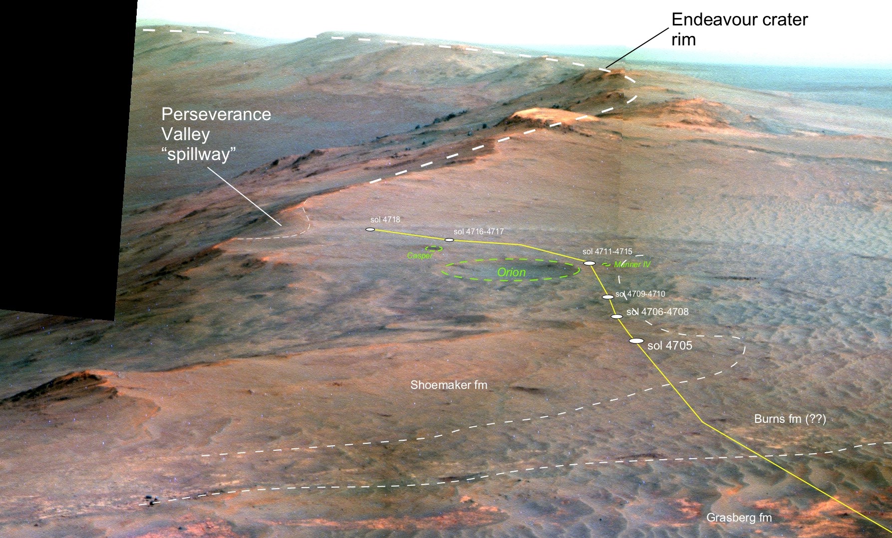
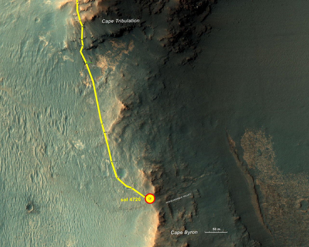
Perspective view of Opportunity’s traverse along Endeavour crater rim over the last few weeks towards the Perseverance Valley “spillway” on Mars during Spring 2017. The entry point for the planned drive back into the crater is visible as the low notch just to the left (east) of the current (sol 4718) rover position. Credit: NASA/JPL/Cornell/NMMNH /Larry Crumpler
Exploring the ancient valley is the main science destination of the current two-year extended mission (EM #10) for the teenaged robot, that officially began Oct. 1, 2016. It’s just the latest in a series of extensions going back to the end of Opportunity’s prime mission in April 2004.
What are the immediate tasks ahead that Opportunity must accomplish before descending down the gully to thoroughly and efficiently investigate the research objectives?
In a nutshell, extensive imaging from a local high point promontory to create a long-baseline 3 D stereo image of the valley and a “walk-about” to assess the local geology.
The rover is collecting images from two widely separated points at a dip at the valley spillway to build an “extraordinarily detailed three-dimensional analysis of the terrain” called a digital elevation map.
“Opportunity has been working on a panorama from the overlook for the past couple of sols. The idea is to get a good overview of the valley from a high point before driving down it,” Crumpler explains.
“But before we drive down the valley, we want to get a good sense of the geologic features here on the head of the valley. It could come in handy as we drive down the valley and may help us understand some things, particularly the lithology of any materials we find on the valley floor or at the terminus down near the crater floor.”
“So we will be doing a short “walk-about” here on the outside of the crater rim near the “spillway” into the valley.”
“We will drive down it to further assess its origin and to further explore the structure and stratigraphy of this large impact crater.”
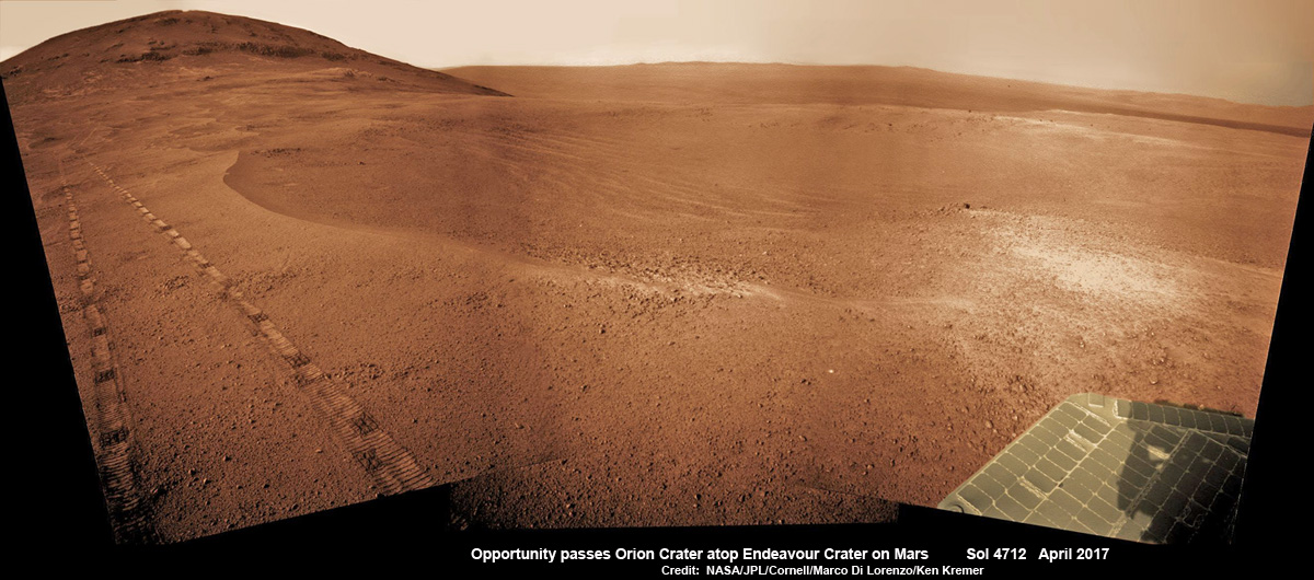
NASA’s Opportunity Mars rover passed near this small, 90-foot-wide and relatively fresh crater in April 2017, during the 45th anniversary of the Apollo 16 mission to the moon. The rover team chose to call it “Orion Crater,” after the Apollo 16 lunar module, Orion, which carried astronauts John Young and Charles Duke to and from the surface of the moon in April 1972 while crewmate Ken Mattingly piloted the Apollo 16 command module, Casper, in orbit around the moon. The rover’s Navigation Camera (Navcam) recorded this view assembled from raw images taken on Sol 4712 (26 April 2017) and colorized. Credit: NASA/JPL/Cornell/Marco Di Lorenzo/Ken Kremer/kenkremer.com
The six wheeled rover landed on Mars on January 24, 2004 PST on the alien Martian plains at Meridiani Planum – as the second half of a stupendous sister act.
Expected to last just 3 months or 90 days, Opportunity has now endured nearly 13 ½ years or an unfathomable 53 times beyond the “warrantied” design lifetime.
Her twin sister Spirit, had successfully touched down 3 weeks earlier on January 3, 2004 inside 100-mile-wide Gusev crater and survived more than six years.
Opportunity has been exploring Endeavour almost six years – since arriving at the humongous crater in 2011. Endeavour crater was formed when it was carved out of the Red Planet by a huge meteor impact billions of years ago.
“Endeavour crater dates from the earliest Martian geologic history, a time when water was abundant and erosion was relatively rapid and somewhat Earth-like,” explains Crumpler.
Exactly what the geologic process was that carved Perseverance Valley into the rim of Endeavour Crater billions of years ago has not yet been determined, but there are a wide range of options researchers are considering.
“Among the possibilities: It might have been flowing water, or might have been a debris flow in which a small amount of water lubricated a turbulent mix of mud and boulders, or might have been an even drier process, such as wind erosion,” say NASA scientists.
“The mission’s main objective with Opportunity at this site is to assess which possibility is best supported by the evidence still in place.”
Extensive imaging with the mast mounted pancam and navcam cameras is currently in progress.
“The long-baseline stereo imaging will be used to generate a digital elevation map that will help the team carefully evaluate possible driving routes down the valley before starting the descent,” said Opportunity Project Manager John Callas of JPL, in a statement.
“Reversing course back uphill when partway down could be difficult, so finding a path with minimum obstacles will be important for driving Opportunity through the whole valley. Researchers intend to use the rover to examine textures and compositions at the top, throughout the length and at the bottom, as part of investigating the valley’s history.”
The team is also dealing with a new wheel issue and evaluating fixes. The left-front wheel is stuck due to an actuator stall.
“The rover experienced a left-front wheel steering actuator stall on Sol 4750 (June 4, 2017) leaving the wheel ‘toed-out’ by 33 degrees,” the team reported in a new update.
Thus the extensive Pancam panorama is humorously being called the “Sprained Ankle Panorama.” Selected high-value targets of the surrounding area will be imaged with the full 13-filter Pancam suite.
After reaching the bottom of Perseverance Valley, Opportunity will explore the craters interior for the first time during the mission.
“Once down at the end of the valley, Opportunity will be directed to explore the crater fill on a drive south at the foot of the crater walls,” states Crumpler.
As of today, June 17, 2017, long lived Opportunity has survived over 4763 Sols (or Martian days) roving the harsh environment of the Red Planet.
Opportunity has taken over 220,800 images and traversed over 27.87 miles (44.86 kilometers) – more than a marathon.
See our updated route map below. It shows the context of the rovers over 13 year long traverse spanning more than the 26 mile distance of a Marathon runners race.
The rover surpassed the 27 mile mark milestone on November 6, 2016 (Sol 4546).
NASA’s Opportunity rover acquired this Martian panoramic view from a promontory that overlooks Perseverance Valley below – scanning from north to south. It is centered on due East and into the interior of Endeavour crater. Perseverance Valley descends from the right and terminates down near the crater floor in the center of the panorama. The far rim of Endeavour crater is seen in the distance, beyond the dark floor. Rover deck and wheel tracks at right. This navcam camera photo mosaic was assembled from raw images taken on Sol 4730 (14 May 2017) and colorized. Credit: NASA/JPL/Cornell/Ken Kremer/kenkremer.com/Marco Di Lorenzo
As of Sol 4759 (June 13, 2017) the power output from solar array energy production is currently 343 watt-hours with an atmospheric opacity (Tau) of 0.842 and a solar array dust factor of 0.529, before heading into another southern hemisphere Martian winter later in 2017. It will count as Opportunity’s 8th winter on Mars.
“The science team is really jazzed at starting to see this area up close and looking for clues to help us distinguish among multiple hypotheses about how the valley formed,” said Opportunity Project Scientist Matt Golombek of NASA’s Jet Propulsion Laboratory, Pasadena, California.
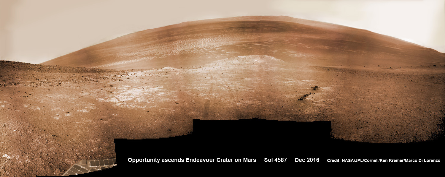
NASA’s Opportunity rover scans around and across to vast Endeavour crater on Dec. 19, 2016, as she climbs steep slopes on the way to reach a water carved gully along the eroded craters western rim. Note rover wheel tracks at center. This navcam camera photo mosaic was assembled from raw images taken on Sol 4587 (19 Dec. 2016) and colorized. Credit: NASA/JPL/Cornell/Ken Kremer/kenkremer.com/Marco Di Lorenzo
Meanwhile Opportunity’s younger sister rover Curiosity traverses and drills into the lower sedimentary layers at the base of Mount Sharp.
And NASA continues building the next two robotic missions due to touch down in 2018 and 2020.
13 Year Traverse Map for NASA’s Opportunity rover from 2004 to 2017. This map shows the entire 44 kilometer (27 mi) path the rover has driven on the Red Planet during over 13 years and more than a marathon runners distance for over 4763 Sols, or Martian days, since landing inside Eagle Crater on Jan 24, 2004 – to current location at the western rim of Endeavour Crater at the head of Perseverance Valley. After studying Spirit Mound and ascending back uphill the rover has reached her next destination in May 2017- the Martian water carved gully at Perseverance Valley near Orion crater. Rover surpassed Marathon distance on Sol 3968 after reaching 11th Martian anniversary on Sol 3911. Opportunity discovered clay minerals at Esperance – indicative of a habitable zone – and searched for more at Marathon Valley. Credit: NASA/JPL/Cornell/ASU/Marco Di Lorenzo/Ken Kremer/kenkremer.com
Stay tuned here for Ken’s continuing Earth and planetary science and human spaceflight news.
Learn more about the Opportunity rover and upcoming SpaceX launch of BulgariaSat 1, recent SpaceX Dragon CRS-11 resupply launch to ISS, NASA missions and more at Ken’s upcoming outreach events at Kennedy Space Center Quality Inn, Titusville, FL:
June 17-19: “Opportunity Mars rover, SpaceX BulgariaSat 1 launch, SpaceX CRS-11 and CRS-10 resupply launches to the ISS, Inmarsat 5 and NRO Spysat, EchoStar 23, SLS, Orion, Commercial crew capsules from Boeing and SpaceX , Heroes and Legends at KSCVC, ULA Atlas/John Glenn Cygnus launch to ISS, SBIRS GEO 3 launch, GOES-R weather satellite launch, OSIRIS-Rex, Juno at Jupiter, InSight Mars lander, SpaceX and Orbital ATK cargo missions to the ISS, ULA Delta 4 Heavy spy satellite, Curiosity explores Mars, Pluto and more,” Kennedy Space Center Quality Inn, Titusville, FL, evenings
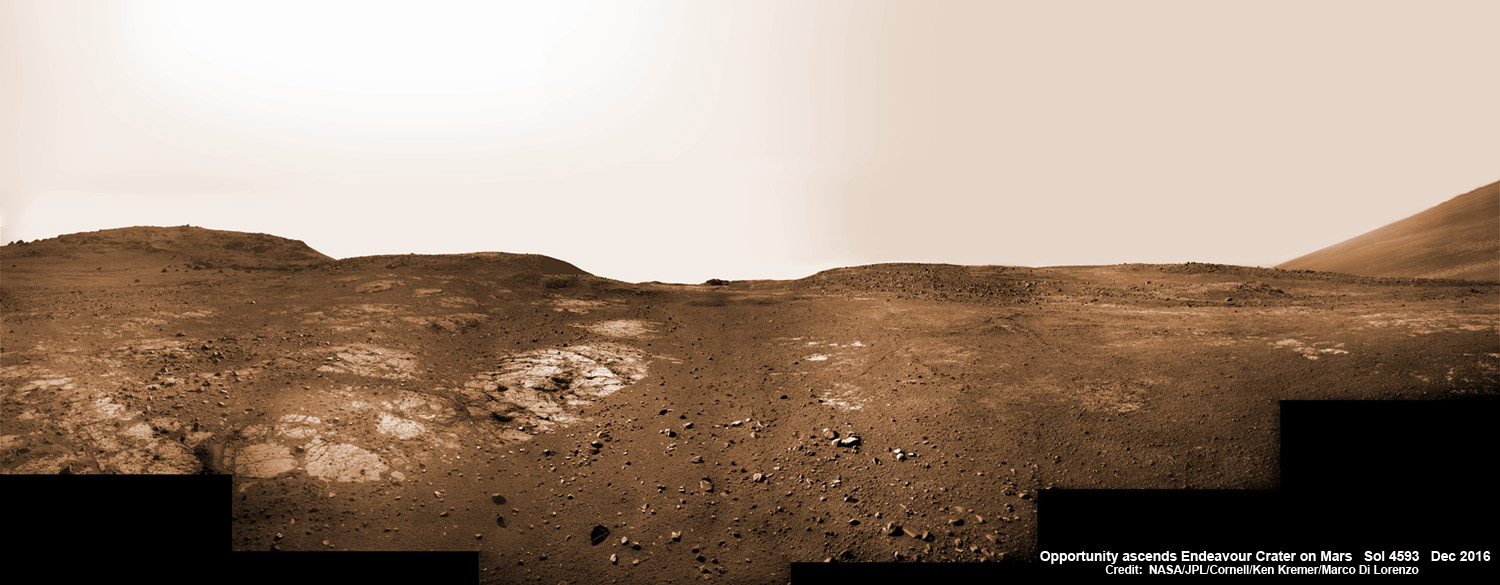
This graphic shows the route that NASA’s Mars Exploration Rover Opportunity drove in its final approach to “Perseverance Valley” on the western rim of Endeavour Crater during spring 2017. Credits: NASA/JPL-Caltech/Univ. of Arizona/NMMNH13 Years on Mars! On Christmas Day 2016, NASA’s Opportunity rover scans around vast Endeavour crater as she ascends steep rocky slopes on the way to reach a water carved gully along the eroded craters western rim. This navcam camera photo mosaic was assembled from raw images taken on Sol 4593 (25 Dec. 2016) and colorized. Credit: NASA/JPL/Cornell/Ken Kremer/kenkremer.com/Marco Di Lorenzo