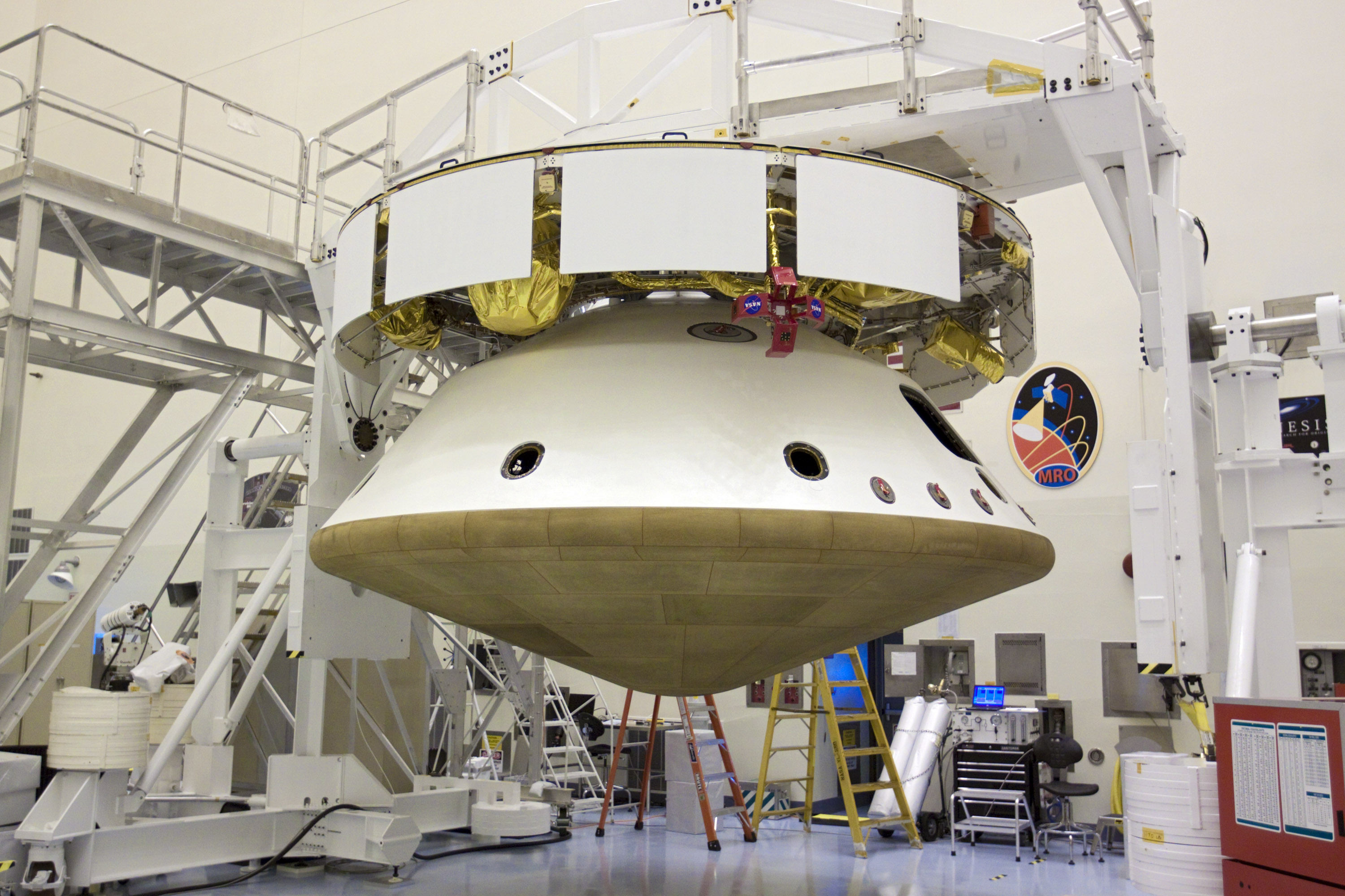
Curiosity Mars Science Laboratory (MSL)- all elements assembled into flight configuration in the Payload Hazardous Servicing Facility at NASA’s Kennedy Space Center in Florida. The top portion is the cruise stage attached to the aeroshell (containing the compact car-sized rover) with the heat shield on the bottom. Launch of MSL aboard a United Launch Alliance Atlas V rocket is scheduled for Nov. 25 from Space Launch Complex 41 on Cape Canaveral Air Force Station in Florida. Credit: NASA/Glenn Benson
[/caption]
Take a good last, long look at the magnificent robot that is Curiosity, because she’s been all buttoned up for her long Martian voyage in search of the ingredients of life. After years of exhaustive work, the most technologically advanced surface robotic rover ever to be sent beyond Earth has been assembled into the flight configuration, a NASA spokesperson informed Universe Today.
The next time Curiosity opens her eyes she will have touched down at the foot of a layered mountain inside the planet’s Gale crater.
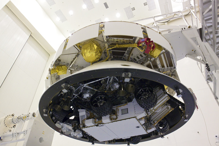
Curiosity Mars rover folded for flight and mated to the cruise stage. The cruise stage provides solar power, thrusters for navigation, and heat exchangers to the rover during its flight from Earth to Mars. Credit: NASA/Glenn Benson
Curiosity – NASA’s next Mars rover – is formally known as the Mars Science Laboratory (or MSL) and has entered the final stages of preflight processing.
After extensive quality assurance testing, Curiosity has been encapsulated for the final time inside the aeroshell that will be her home during the 10 month long interplanetary cruise to Mars. Furthermore, she’s been attached to the cruise stage that will guide her along the path from the home planet to the red planet.
Curiosity Mars Science Laboratory (MSL) assembled into flight configuration in the Payload Hazardous Servicing Facility at NASA’s Kennedy Space Center in Florida. The rover Curiosity has 10 science instruments designed to search for evidence on whether Mars has had environments favorable to microbial life, including chemical ingredients for life. Credit: NASA/Glenn Benson
The work to combine all the components into an integrated assembly was carried out inside the clean room facilities of the Payload Hazardous Servicing Facility at NASA’s Kennedy Space Center (KSC) in Florida.
The aeroshell is comprised of the heat shield and back shell.
The job of the aeroshell is to protect Curiosity from the intense heat of several thousand degrees F(C) generated by friction as the delicate assemblage smashes into the Martian atmosphere at about 13,200 MPH (5900 m/s) and plummets some 81 miles during the terrifying seven minute long entry, descent and landing (EDL) on the surface.
The massive 2000 lb (900 kg) rover is folded up and mated to the back shell powered descent vehicle, known as the PDV or Sky Crane. The spacecraft is designed to steer itself through a series of S-curve maneuvers to slow the spacecraft’s descent through the Martian atmosphere.
In the final moments, the rocket powered Sky crane will lower the robot on tethers and then safely set Curiosity down onto the ground at a precise location inside the chosen landing site astride a layered mountain in Gale Crater believed to contain phyllosilicate clays and hydrated sulfate minerals that formed in liquid water.
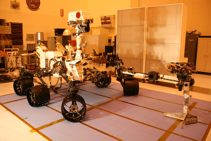
The robot is the size of a compact car and measures three meters in length, roughly twice the size of the MER rovers; Spirit and Opportunity. It is equipped with 10 science instruments for a minimum two year expedition across Gale crater.
NASA's Curiosity Mars Science Laboratory Rover
Inside the Clean room at the Payload Hazardous Servicing Facility at the Kennedy Space Center.
The science payload weighs ten times more than any prior Mars rover mission. Curiosity will zap rocks with a laser and deftly maneuver her outstretched robotic arm to retrieve and analyze dozens of Martian soil samples. Credit: Ken Kremer
Curiosity will search for the ingredients of life including water and organic molecules and environmental conditions that could have been hospitable to sustaining Martian microbial life forms if they ever existed in the past or survived to the present through dramatic alterations in Mars climatic and geologic history.
Liftoff of the $2.5 Billion Curiosity rover is slated for Nov. 25 from Cape Canaveral Air Force Station in Florida on a United Launch Alliance Atlas V booster rocket. The launch window to Mars extends until Dec. 18.
This coming week, Curiosity will be encapsulated into the clamshell like payload fairing and the MSL logo will then be applied to the fairing, KSC spokesman George Diller told Universe Today. It will then be hoisted onto the payload transporter and carefully conveyed to Space Launch Complex 41 on Nov. 2, for mating atop the Atlas V rocket.
Mars Science Laboratory Aeroshell with Curiosity enclosed inside. Credit: NASA
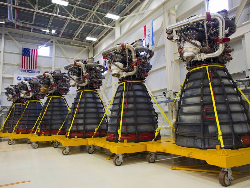
Six main rocket engines from the Endeavour and Atlantis shuttles. Credit: NASA/Dimitri Gerondidakis
[/caption]
That’s a lot of power under one roof! For the first time in… well, ever… all fifteen Space Shuttle Main Engines (SSMEs) are together inside NASA’s Engine Shop at Kennedy Space Center. They will be prepped for shipment to Stennis Space Center in Mississippi where they’ll become part of the propulsion used on NASA’s next generation heavy-lift rocket: the Space Launch System.
The engines, built by Pratt & Whitney Rocketdyne, are each 14 feet (4.2 meters) long & 7.5 feet (2.3 meters) in diameter at the end of its nozzle, and weighs approximately 7,000 lbs (3175 kg).
Photo from a test firing of an SSME at the Stennis Space Center in 1981. Credit: NASA.
Each engine is capable of generating a force of nearly 400,000 pounds (lbf) of thrust at liftoff, and consumes 350 gallons (1,340 liters) of fuel per second. They are engineered to burn liquid hydrogen and liquid oxygen, creating exhaust composed primarily of water vapor.
The engines will be incorporated into the Space Launch System (SLS), which is designed to carry the Orion Multi-Purpose Crew Vehicle – also currently in development – as well as serve as backup for commercial and international transportation to the ISS. By utilizing current technology and adapting it for future needs, NASA will be able to make the next leap in human spaceflight and space exploration – while getting the most “bang” out of the taxpayers’ bucks.
“NASA has been making steady progress toward realizing the president’s goal of deep space exploration, while doing so in a more affordable way. We have been driving down the costs on the Space Launch System and Orion contracts by adopting new ways of doing business and project hundreds of millions of dollars of savings each year.”
– NASA Deputy Administrator Lori Garver
Nine of the 15 SSMEs await shipment inside NASA's Engine Shop. Each weighs approximately 7,000 lbs. Credit: NASA.
While it’s sad to see these amazing machines removed from the shuttles, it’s good to know that they still have plenty of life left in them and will soon once again be able to take people into orbit and beyond!
At 4.4 kilometers in elevation, California's Mt. Whitney is the highest point in the continental United States. Image credit: NASA/GSFC/METI/ERSDAC/JAROS, and U.S./Japan ASTER Science Team
[/caption]NASA and Japan recently announced a new and improved digital topographic map of Earth, which was produced with detailed measurements from NASA’s Terra spacecraft.
The new data covers over 99 percent of Earth’s landmass and spans from 83 degrees north latitude to 83 degrees south. Each elevation measurement point in the data is only 30 meters apart.
How were scientists able to improve on previous generations of detailed topographic maps?
The new model, known as a global digital elevation model, was created from images collected by the Japanese Advanced Spaceborne Thermal Emission and Reflection Radiometer, or ASTER, instrument aboard NASA’s Terra spacecraft. To create a “stereo pair” image,scientists can take two slightly offset images and combine them to create a three-dimensional effect of depth.
The previous version of the global digital elevation model was released in June of 2009 by NASA and Japan’s Ministry of Economy, Trade and Industry.
“The ASTER global digital elevation model was already the most complete, consistent global topographic map in the world,” said ASTER program scientist Woody Turner, “With these enhancements, its resolution is in many respects comparable to the U.S. data from NASA’s Shuttle Radar Topography Mission, while covering more of the globe.”
The ASTER team added 260,000 stereo-pair images to improve the previous model, which improved spatial resolution, increased horizontal and vertical accuracy, and provided the ability to identify lakes as small as 1 kilometer in diameter.
“This updated version of the ASTER global digital elevation model provides civilian users with the highest-resolution global topography data available,” said ASTER science team lead Mike Abrams. “These data can be used for a broad range of applications, from planning highways and protecting lands with cultural or environmental significance, to searching for natural resources.”
Arguably one of America's most magnificent national parks is the Grand Canyon in northern Arizona. Image credit: NASA/GSFC/METI/ERSDAC/JAROS, and U.S./Japan ASTER Science Team
Joining together in a collaborative effort, NASA and METI are contributing data for the ASTER topographic map to the Group on Earth Observations, for use in the group’s Global Earth Observation System of Systems. No, the previous statement wasn’t a typo – the “system of systems” is an international effort, which uses shared Earth observation data to help monitor and forecast global environmental changes.
One of five instruments launched on Terra in 1999, ASTER acquires images from visible to thermal infrared wavelengths, with spatial resolutions ranging from about 15 to 90 meters. ASTER’s science team is a joint effort between the United States and Japan.
The ASTER data was validated by NASA, METI, Japan’s Earth Remote Sensing Data Analysis Center (ERSDAC), and the U.S. Geological Survey, with additional support from the U.S. National Geospatial-Intelligence Agency and other collaborators. NASA’s Land Processes Distributed Active Archive Center is handling the distribution of the new ASTER global digital elevation model.
If you’d like to download the ASTER global digital elevation model to study at no cost, you can do so at: https://lpdaac.usgs.gov/ or http://www.ersdac.or.jp/GDEM/E/4.html
To learn more about ASTER, or NASA’s Terra mission, visit: http://asterweb.jpl.nasa.gov/ and http://www.nasa.gov/terra
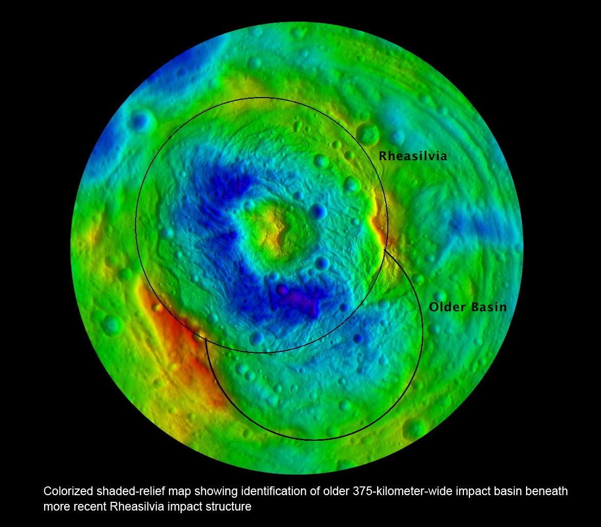
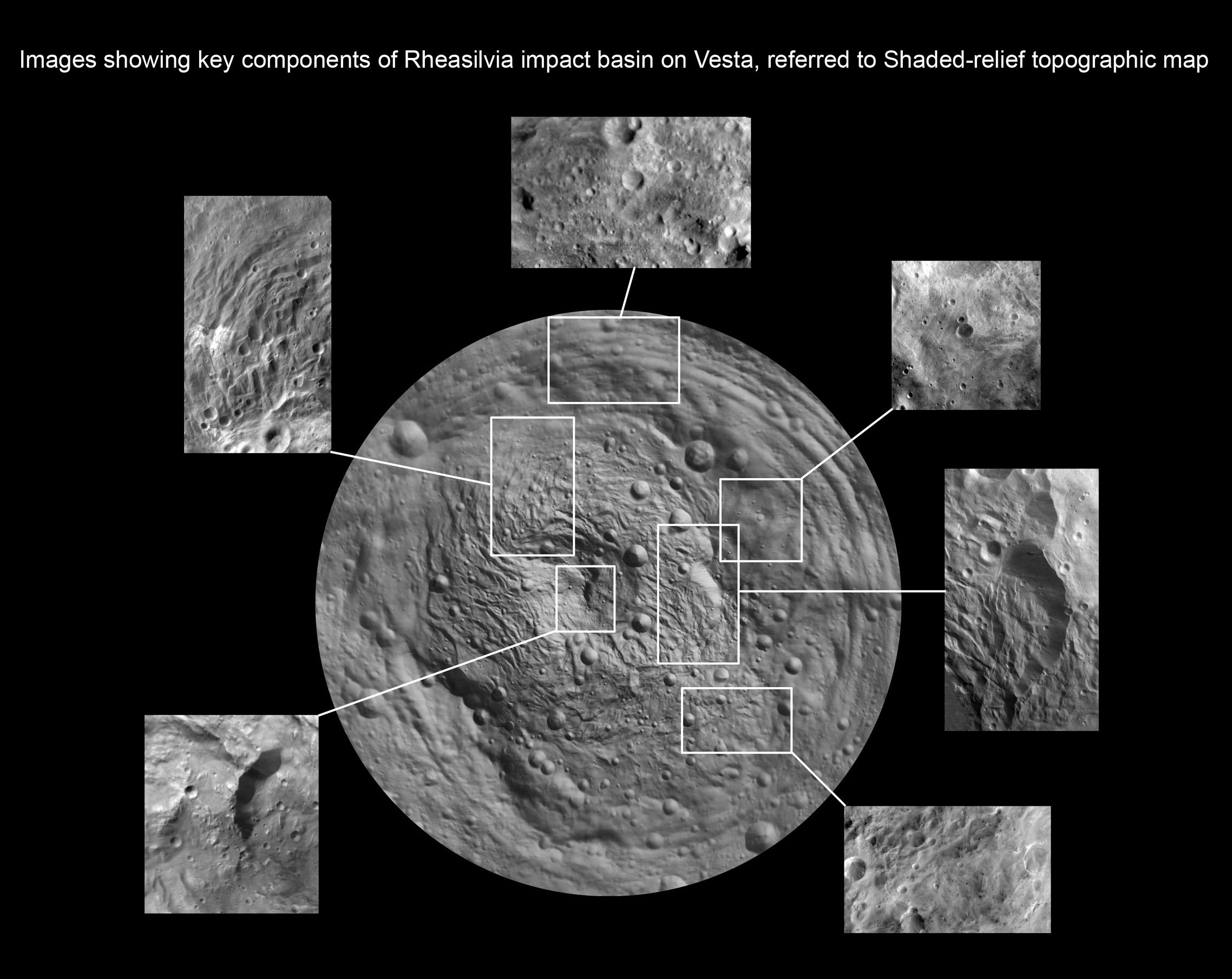
Southern Hemisphere of Vesta; Rheasilvia and Older Basin. Colorized shaded-relief map showing identification of older 375-kilometer-wide impact basin beneath and overlapping with the more recent Rheasilvia impact structure at asteroid Vesta’s South Pole. Credit: NASA/JPL-Caltech/UCLA/MPS/DLR/IDA
[/caption]
Scientists leading NASA’sDawn mission have discovered a 2nd giant impact basin at the south pole of the giant asteroid Vesta, which has been unveiled as a surprisingly “dichotomous” and alien world. Furthermore, the cosmic collisions that produced these two basins shuddered through the interior and created vast Vestan troughs, a Dawn scientist told Universe Today.
The newly discovered impact basin, nicknamed ‘Older Basin’, is actually significantly older in age compared to the initially discovered South Pole basin feature named ‘Rheasilvia’ – perhaps by more than a billion years. And that is just one of the many unexplained mysteries yet to be reconciled by the team as they begin to sift through the millions of bits of new data streaming back daily to Earth.
Scientists speculate that ‘Older Basin’ is on the order of 3.8 Billion years old, whereas ‘Rheasilvia’ might be as young as about 2.5 Billion years, but those are just tentative estimates at this time and subject to change. Measurements so far indicate Rheasilvia is composed of basaltic material.
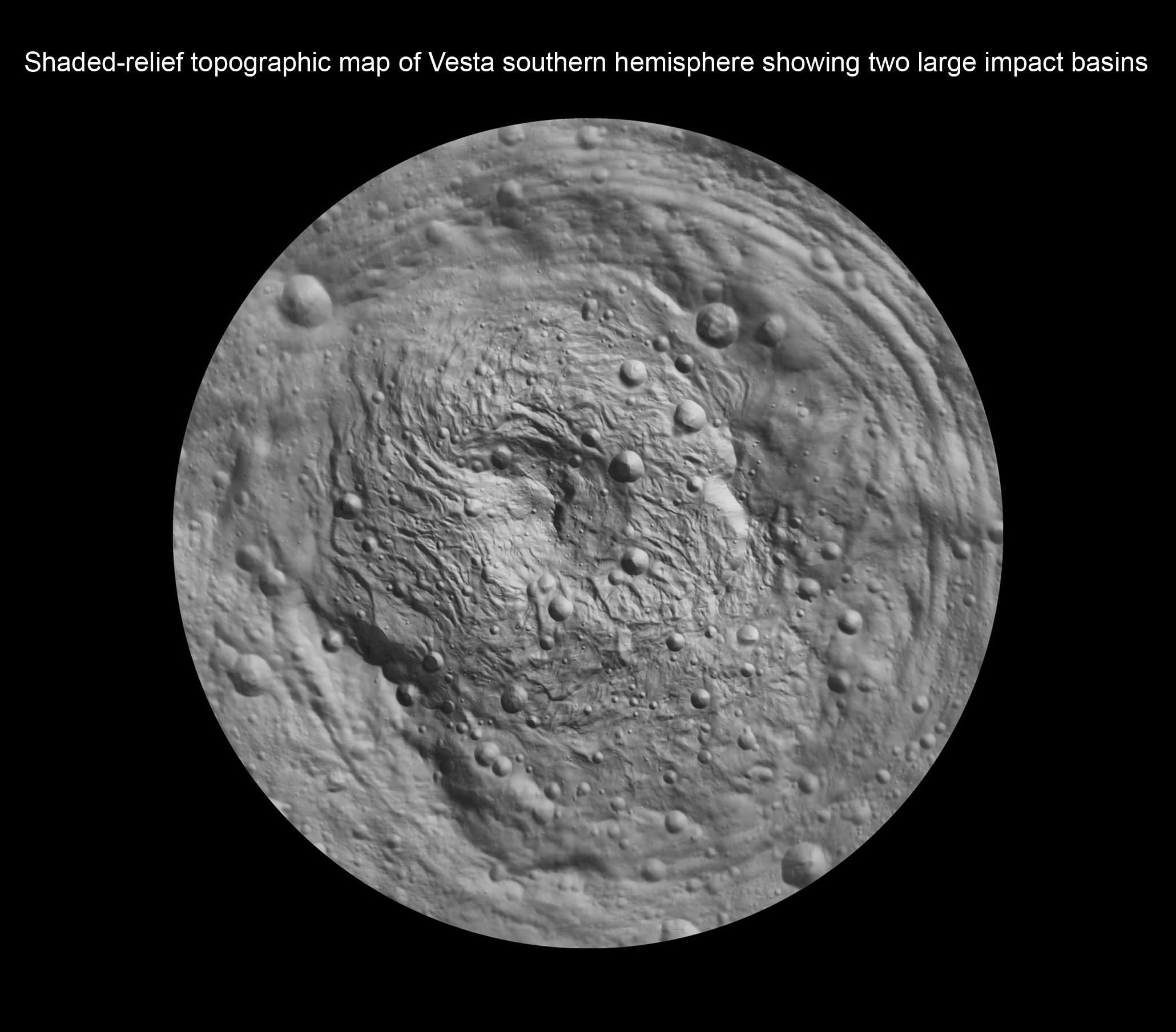
Shaded-relief topographic map of Vesta southern hemisphere showing two large impact basins - Rheasilvia and Older Basin.
Credit: NASA/JPL-Caltech/UCLA/MPS/DLR/IDA
“We found many surprising things at Vesta, which is quite unique and the results have exceeded our expectations”, said Dr. Carol Raymond, Dawn deputy principal investigator, of NASA’s Jet Propulsion Laboratory, Pasadena, Calif.
Researchers presented the latest findings from Dawn’s initial science mapping orbit at a news briefing at the annual meeting of the Geological Society of America in Minneapolis, Minn., on Oct. 13.
The team considers Vesta to be the smallest terrestrial planet.
Since achieving orbit in July, Dawn’s Framing Cameras (FC) have imaged most of Vesta at about 250 meter resolution and the Visible and Infrared mapping spectrometer(VIR) at about 700 meter resolution. The measurements were collected at the survey orbit altitude of 2700 km. Before Dawn, Vesta was just a fuzzy blob in humankind’s most powerful telescopes.
Vesta from Hubble (top) as a fuzzy blob and from Dawn in orbit (bottom) in crystal clear high resolution.
Credit: NASA/JPL-Caltech/ UCLA/MPS/DLR/IDA
“There is a global dichotomy on Vesta and a fundamental difference between the northern and southern hemispheres”, said Raymond. “The northern hemisphere is older and heavily cratered in contrast to the brighter southern hemisphere where the texture is more smooth and there are lots of sets of grooves. There is a massive mountain at the South Pole. One of the more surprising aspects is the set of deep equatorial troughs.”
“There is also a tremendous and surprising diversity of surface color and morphology. The south is consistent with basaltic lithology and the north with impacts. We are trying to make sense of the data and will integrate that with the high resolution observations we are now collecting.”
Indeed Vesta’s completely unique and striking dichotomy can be directly traced back to the basins which were formed by ancient cataclysmic impacts resulting in shockwaves that fundamentally altered the surface and caused the formation of the long troughs that ring Vesta at numerous latitudes.
“The troughs extend across 240 degrees of longitude,” said Debra Buczkowski, Dawn participating scientist, of the Applied Physics Laboratory at Johns Hopkins University, Laurel, Md. “Their formation can be tied back to the two basins at the South Pole.”
Asteroid Vesta and Equatorial Grooves
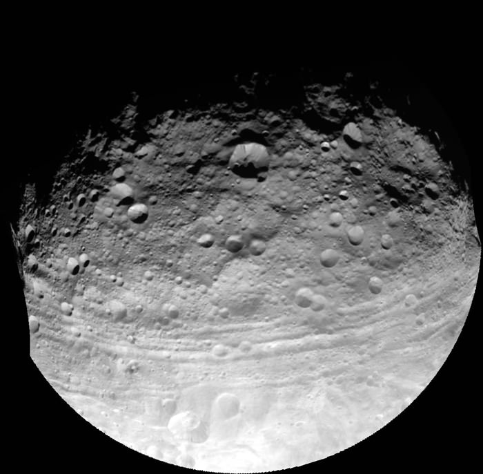
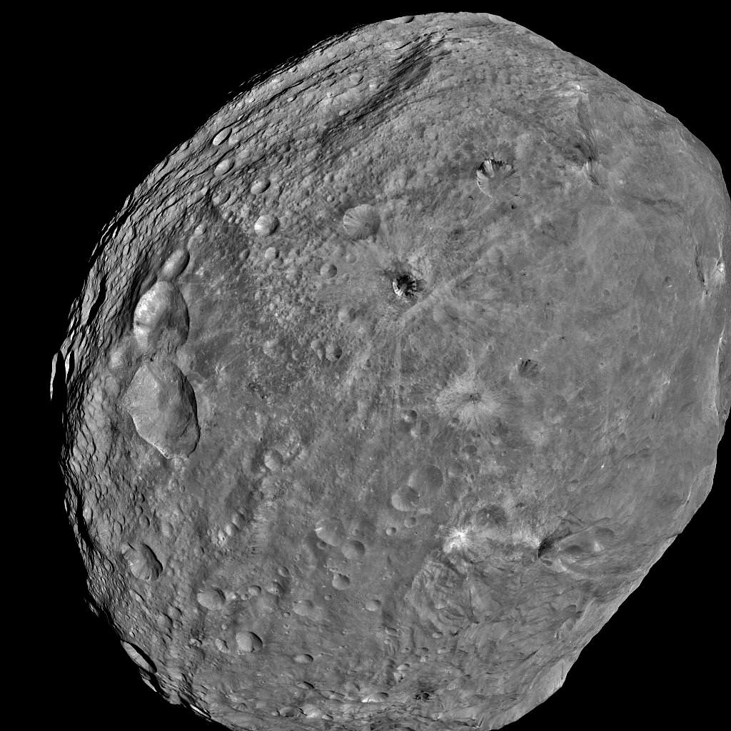
This full view of the giant asteroid Vesta was taken by NASA’s Dawn spacecraft, as part of a rotation characterization sequence on July 24, 2011, at a distance of 3,200 miles (5,200 kilometers). A rotation characterization sequence helps the scientists and engineers by giving an initial overview of the character of the surface as Vesta rotated underneath the spacecraft. This view of Vesta shows impact craters of various sizes and grooves parallel to the equator. The resolution of this image is about 500 meters per pixel. Credit: NASA/JPL-Caltech/UCLA/MPS/DLR/IDA
In an exclusive follow up interview with Universe Today, Raymond said “We believe that the troughs formed as a direct result of the impacts,” said “The two sets of troughs are associated with the two large basins [Rheasilvia and Older Basin].”
“The key piece of evidence presented was that the set of troughs in the northern hemisphere, that look older (more degraded) are circumferential to the older impact basin,” Raymond told me.
“The equatorial set are circumferential to Rheasilvia. That Rheasilvia’s age appears in places to be much younger is at odds with the age of the equatorial troughs. An explanation for that could be resurfacing by younger mass wasting features (landslides, slumps). We will be working on clarifying all these relationships in the coming months with the higher resolution HAMO (High Altitude Mapping Orbit) data.”
Dawn has gradually spiraled down closer to Vesta using her exotic ion thrusters and began the HAMO mapping campaign on Sept. 29.
Surface features are dated by crater counting methodology.
“Preliminary crater counting age dates for the equatorial trough region yields a very old age (3.8 Billion years). So there is a discrepancy between the apparent younger age for the Rheasilvia basin and the old age for the troughs. These could be reconciled if Rheasilvia is also 3.8 Billion years old but the surface has been modified by slumping or other processes,” Raymond elaborated.
Time will tell as further data is analyzed.
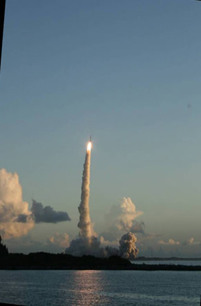
Dawn launch on September 27, 2007 by a Delta II Heavy rocket from Cape Canaveral Air Force Station, Florida. Credit: Ken Kremer
“Vesta is full of surprises, no more so than at the South Pole,” said Paul Schenk at the GSA briefing. Schenk is a Dawn participating scientist of the Lunar and Planetary Institute, Houston, Texas.
The ‘Rheasilvia’ basin was initially discovered in images of Vesta taken a decade ago by the Hubble Space Telescope which revealed it as a gaping hole in the southern hemisphere. But it wasn’t until Dawn entered orbit on July 16, 2011 after a nearly four year interplanetary journey that Earthlings got their first close up look at the mysterious polar feature and can now scrutinize it in detail to elucidate its true nature.
“The South Pole [Rheasilvia] basin is a roughly circular, impact structure and a deep depression dominated by a large central mound,” said Schenk. “It shows sharp scarps, smooth areas, landslide deposits, debris flows. It’s about 475 km in diameter and one of the deepest (ca. 20 -25 km) impact craters in the solar system.”
The central peak is an enormous mountain, about 22 km high and 180 km across- one of the biggest in the solar system. “It’s comparable in some ways to Olympus Mons on Mars,” Schenk stated.
“We were quite surprised to see a second basin in the mapping data outside of Rheasilvia. This was unexpected. It’s called ‘Older Basin’ for now.”
‘Older Basin’ is about 375 km in diameter. They overlap at the place where Rheasilvia has a missing rim.
“These basins are interesting because we believe Vesta is the source of a large number of meteorites, the HED meteorites that have a spread of ages,” Schenk explained.
Images showing key components of Rheasilvia impact basin on Vesta in high resolution ,referred to Shaded-relief topographic map. Credit: NASA/JPL-Caltech/ UCLA/MPS/DLR/IDA
Multiple large impacts over time may explain the source of the HED (Howardite, Eucrite and Diogenite) meteorites.
“We did expect large impacts on Vesta, likely associated with the late heavy bombardment recognized in the lunar impact record,” Raymond told Universe Today. “The surprising element is that the two apparently largest impacts – keeping in mind that other larger impact basins may be lurking under the regolith – are overlapping.”
Dawn’s VIR spectrometer has detected pyroxene bands covering Vesta’s surface, which is indicative of typical basaltic material, said Federico Tosi, a VIR team member of the Italian Space Agency, Rome. “Vesta has diverse rock types on its surface.”
“VIR measured surface temperatures from 220K to 270 K at the 5 micron wavelength. The illuminated areas are warmer.”
So far there is no clear indication of olivine which would be a marker for seeing Vesta’s mantle, Tossi elaborated.
The VIR spectrometer combines images, spectral information and temperature that will allow researchers to evaluate the nature, composition and evolutionary forces that shaped Vesta’s surface.
The team is absolutely thrilled to see a complicated geologic record that’s been preserved for study with lots of apparent surface layering and surprisingly strong and complex structural features with a large range of color and brightness.
Stay tuned for a year of Vestan delights !
Asteroid Vesta from Dawn
South Pole Rheasilvia basin is at lower right. NASA's Dawn spacecraft obtained this image of the giant asteroid Vesta with its framing camera on July 24, 2011 from a distance of about 3,200 miles (5,200 kilometers). Dawn entered orbit around Vesta on July 16, and will spend a year orbiting the body.
Credit: NASA/JPL-Caltech/UCLA/MPS/DLR/IDA
Artist's rendering of a vacuum tube, one of the main components of an atomic clock. Credit: NASA
[/caption]
When people think of space technologies, many think of solar panels, propulsion systems and guidance systems. One important piece of technology in spaceflight is an accurate timing device.
Many satellites and spacecraft require accurate timing signals to ensure the proper operation of scientific instruments. In the case of GPS satellites, accurate timing is essential, otherwise anything relying on GPS signals to navigate could be misdirected.
The third technology demonstration planned by NASA’s Jet Propulsion Laboratory is the Deep Space Atomic Clock. The DSAC team plans to develop a small, low-mass atomic clock based on mercury-ion trap technology and demonstrate it in space.
What benefits will a new atomic clock design offer NASA and other players in near-Earth orbit and the rest of our solar system?
The Deep Space Atomic Clock demonstration mission will fly and validate an atomic clock that is 10-times more accurate than today’s systems. The project will demonstrate ultra-precision timing in space as well as the benefits said timing offers.
The DSAC will fly on an Iridium spacecraft and make use of GPS signals to demonstrate precision orbit determination and confirm the clock’s performance. As mentioned previously, precise timing and navigation are critical to the performance of many aspects of deep space and near-Earth exploration missions.
The DSAC team believes the demonstration will offer enhancements and cost savings for new missions, which include:
Increase Data Quantity: A factor of 2 to 3 increase in navigation and radio science data quantity by allowing coherent tracking to extend over the full view period of Earth stations.
Improve Data Quality: Up to 10 times more accurate navigation, gravity science, and occultation science at remote solar system bodies by using one-way radiometric links.
Enabling New Missions: Shift towards a more flexible and extensible one-way radio navigation architecture enabling development of capable in-situ satellite navigation systems and autonomous deep space radio navigation.
Reduce Proposed Mission Costs: Reduce mission costs for using the Deep Space Network (DSN) through aperture sharing and one-way downlink only time.
Benefits to GPS: Improve clock stability of the next GPS system by 100 times.
One example use for the DSAC is for a future mission that is a follow-up to the Mars Reconnaissance Orbiter (MRO). A spacecraft equipped with the DSAC could avoid reliance on two-way communications using NASA’s Deep Space Network to perform orbital determination.
One of the benefits of avoiding said reliance on two-way communications would allow the mission to only require the DSN for one-way communication to transmit scientific data to Earth. Reducing the reliance on two-way communications would provide an additional benefit of cost savings.
In the previous example, the DSAC team estimates an $11 million dollar reduction in network operational costs, as well as a 100% increase in the amount of usable science and navigation data that could be received. Overview of Deep Space Atomic Clock (DASC) mission. Image Credit: NASA
The Space Communications and Navigation (SCaN) office in the Human Exploration and Operations Mission Directorate is collaborating with the NASA Office of the Chief Technologist in sponsoring this technology demonstration.
If successful the DSAC flight demonstration mission will bring the improved atomic clock technology to a technological readiness level that will allow it to be used in a wide variety of future space missions.
Read our earlier articles about the other technology demonstrations planned:
The Solar Sail demonstration mission. Credit: NASA
[/caption]
Solar sails, much like anti-matter and ion engines appear at first glance to only exist in science fiction. Many technologies from science fiction however, become science fact.
In the example of solar sails, perfecting the technology would allow spacecraft to travel through our solar system using very little fuel.
NASA has been making strides with solar sail technology. Using the NanoSail-D mission, NASA continues to gather valuable data on how well solar sails perform in space. The Planetary Society will also be testing solar sail technology with their LightSail-1 project sometime next year.
How will NASA (and others) test solar sail technology, and develop it into a common, reliable technology?
The second of three recently announced technology demonstrations, The Solar Sail Demonstration, will test the deployment of a solar sail in space along with testing attitude control. The solar sail will also execute a navigation sequence with mission-capable accuracy.
In order to make science fiction into reality, NASA engineers are testing solar sails that could one day provide the propulsion for deep space missions. Spacecraft using solar sails would travel in our solar system in a similar manner to a sailboat through water, except spacecraft using solar sails would rely on sunlight instead of wind. A spacecraft propelled by a solar sail would use the sail to capture photons emitted from the Sun. Over time, the buildup of the solar photons provides enough thrust for a small spacecraft to travel in space.
NASA’s solar sail demonstration mission will deploy and operate a sail area 7 times larger than ever flown in space. The technology used in the demonstration will be applicable to many future space missions, including use in space weather warning systems to provide timely and accurate warnings of solar flare activity. The solar sail demonstration is a collaborative effort between The National Oceanic and Atmospheric Administration (NOAA), NASA and contractor L’Garde Inc.
NASA lists several capabilities solar sails have to offer, such as:
Orbital Debris: Orbital debris can be captured and removed from orbit over a period of years using the small solar-sail thrust.
De-orbit of spent satellites: Solar sails can be integrated into satellite payloads so that the satellite can be de-orbited at the end of its mission.
Station keeping: Using the low propellantless thrust of a solar sail to provide station keeping for unstable in-space locations.
Deep space propulsion: Payloads free of the Earth’s pull can be continuously and efficiently accelerated to the other planets, or out of the solar system, such as proposed in Project Encounter.
As an example, the GeoStorm project considers locating solar storm warning satellites at pseudo Lagrange points three times further from the Earth by using the solar sail to cancel some solar gravitational pull, thus increasing warning time from ~15 minutes to ~45 minutes.
Providing a satellite with a persistent view of northern or southern latitudes, i.e., a “pole-sitter” project. This allows the observational advantages of today’s geosynchronous satellites for orbits with view angles of the northern and southern high-latitudes.
A solar sail system, measuring 66 feet on each side was tested in 2005 in the world's largest vacuum chamber. Image Credit: NASA
If you’d like to learn more about solar sails, Caltech has a nice “Solar Sailing 101” page at: http://www.ugcs.caltech.edu/~diedrich/solarsails/intro/intro.html
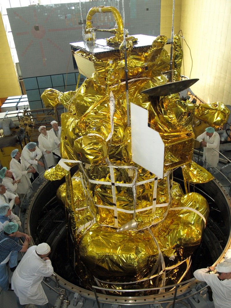
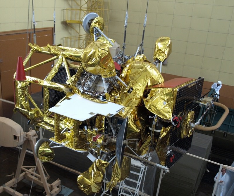
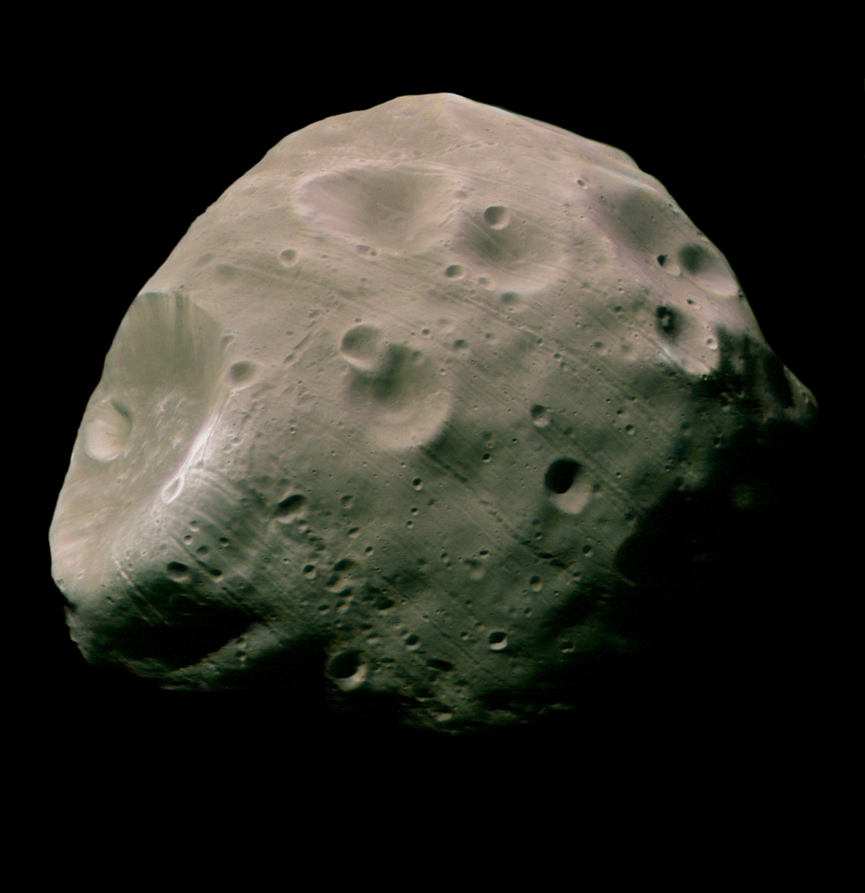
Russian Phobos-Grunt spacecraft set to Launch in November 2011.The flight version of the Phobos-Grunt spacecraft minus its main solar panels is being lowered into a vacuum chamber at NITs RKP test facility in Peresvet, north of Moscow, for thermal, vacuum and electric tests around beginning of June 2011. Credit: NPO Lavochkin
[/caption]
In just over 3 weeks’ time, Russia plans to launch a bold mission to Mars whose objective, if successful , is to land on the Martian Moon Phobos and return a cargo of precious soil samples back to Earth about three years later.
The purpose is to determine the origin and evolution of Phobos and how that relates to Mars and the evolution of the solar system.
Liftoff of the Phobos-Grunt space probe will end a nearly two decade long hiatus in Russia’s exploration of the Red Planet following the failed Mars 96 mission and is currently scheduled to head to space just weeks prior to this year’s other Mars mission – namely NASA’s next Mars rover, the Curiosity Mars Science Laboratory (MSL).
Blastoff of Phobos-Grunt may come as early as around Nov. 5 to Nov. 8 atop a Russian Zenit 3-F rocket from the Baikonur Cosmodrome in Kazakhstan. The launch window extends until about Nov. 25. Elements of the spacecraft are undergoing final prelaunch testing at Baikonur.
Flight version of the Phobos-Grunt spacecraft during assembly in preparation for critical testing in thermal and vacuum chamber at NITs RKP facility closely imitating harsh conditions of the real space flight. Credit: NPO Lovochkin
Baikonur is the same location from which Russian manned Soyuz rockets lift off for the International Space Station. Just like NASA’s Curiosity Mars rover, the mission was originally intended for a 2009 launch but was prudently delayed to fix a number of technical problems.
“November will see the launch of the Phobos-Grunt interplanetary automatic research station aimed at delivering samples of the Martian natural satellite’s soil to Earth’” said Vladimir Popovkin, head of the Russian Federal Space Agency, speaking recently at a session of the State Duma according to the Voice of Russia, a Russian government news agency.
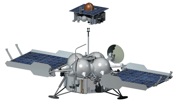
Phobos-Grunt spacecraft
The spacecraft will reach the vicinity of Mars after an 11 month interplanetary cruise around October 2012. Following several months of orbital science investigations of Mars and its two moons and searching for a safe landing site, Phobos-Grunt will attempt history’s first ever touchdown on Phobos. It will conduct a comprehensive analysis of the surface of the tiny moon and collect up to 200 grams of soil and rocks with a robotic arm and drill.
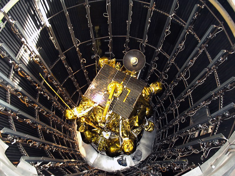
Russian Phobos-Grunt spacecraft prepares for testing inside the vacuum chamber. Credit: NPO Lavochkin
After about a year of surface operations, the loaded return vehicle will blast off from Phobos and arrive back at Earth around August 2014. These would be the first macroscopic samples returned from another body in the solar system since Russia’s Luna 24 in 1976.
“The way back will take between nine and 11 months, after which the return capsule will enter Earth’s atmosphere at a speed of 12 kilometers per second. The capsule has neither parachute nor radio communication and will break its speed thanks to its conical shape,” said chief spacecraft constructor Maksim Martynov according to a report from the Russia Today news agency. He added that there are two soil collection manipulators on the lander because of uncertainties in the characteristics of Phobos soil.
Phobos-Grunt was built by NPO Lavochkin and consists of a cruise stage, orbiter/lander, ascent vehicle, and Earth return vehicle.
The spacecraft weighs nearly 12,000 kg and is equipped with a sophisticated 50 kg international science payload, in particular from France and CNES, the French Space Agency.
Also tucked aboard is the Yinghou-1 microsatellite supplied by China. The 110 kg Yinghou-1 is China’s first probe to launch to Mars and will study the Red Planet’s magnetic and gravity fields and surface environment from orbit for about 1 year.
“It will be the first time such research [at Mars] will be done by two spacecraft simultaneously. The research will help understand how the erosion of Mars’ atmosphere happens,” said Professor Lev Zelyony from the Space Research Institute of the Russian Academy of Science, according to Russia Today.
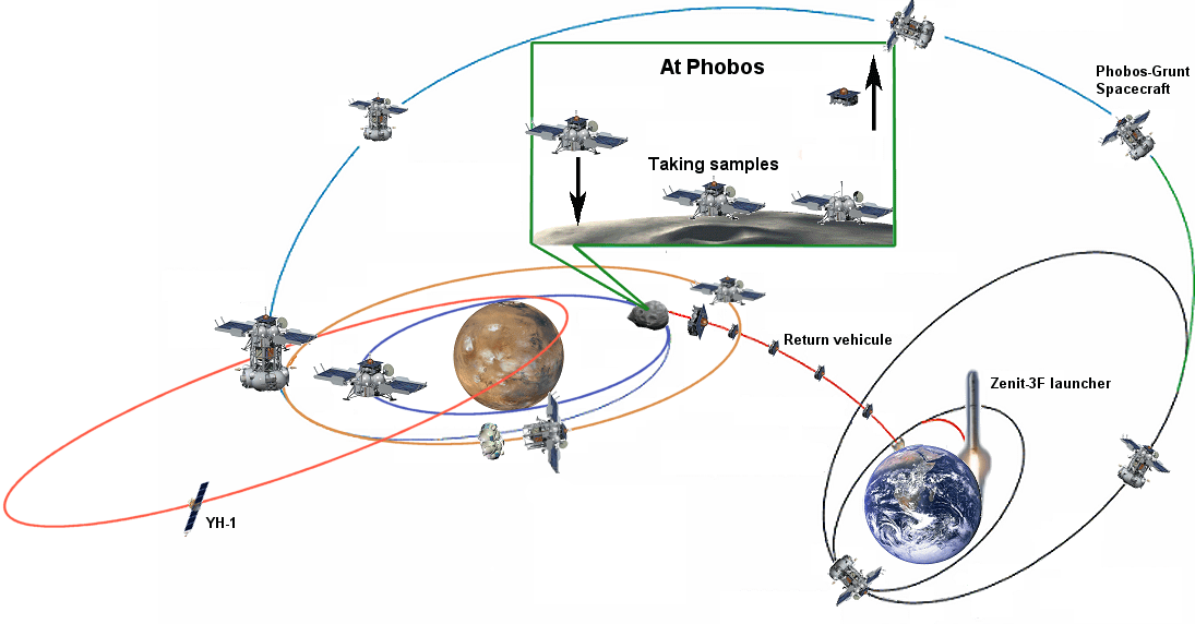
Phobos-Grunt mission scenario. Credit: CNESPhobos seen by Mars Express. Credit: ESA
Conceptual image of The Laser Communications Relay Demonstration. Credit: NASA
[/caption]Quite often, communication rates with remote spacecraft have been a limiting factor when exploring our solar system. For example, it can take up to 90 minutes to transfer one high-resolution image from the Mars Reconnaissance Orbiter to scientists on Earth.
Improving data communication rates would allow scientists to collect additional data from future missions to Mars, Titan or other destinations in our solar system.
How does NASA plan to overcome the current limitations in communication with spacecraft outside Earth orbit?
One of three recently announced technology demonstrations, The Laser Communications Relay Demonstration, will help demonstrate and validate laser-based communications. One of many goals for the LCRD is to provide spacecraft in Earth orbit ( and beyond ) a faster and reliable method of communication than standard radio communications currently in use.
A laser-based communication will allow NASA and other government agencies to perform missions that require higher data rates. In the cases where less data is required, the laser-based systems would consume less power, mass and precious volume inside a spacecraft. Given roughly equal mass, power, and volume, the laser-based communications system offers much higher data rates than a radio-based communications system.
NASA’s goals for the LCRD are to:
Enable reliable, capable, and cost effective optical communications technologies for near earth applications and provide the next steps required toward optical communications for deep space missions
Demonstrate high data rate optical communications technology necessary for:
Near-Earth spacecraft (bi-directional links supporting hundreds of Mbps to Gbps)
Deep Space missions (tens to hundreds of Mbps from distances such as Mars and Jupiter)
Develop, validate and characterize operational models for practical optical communications
Identify and develop requirements and standards for future operational optical communication systems
Establish a strong partnership with multiple government agencies to facilitate crosscutting infusion of optical communications technologies
Develop the industrial base and transfer technology for future space optical communications systems
High-rate communications 10-100 times more capable than current radio systems will also allow for greatly improved connectivity and enable new generations of remote missions that are far more capable than today’s missions. NASA’s LCRD will also provide the satellite communication industry with technology not available today. Laser-based space communications will enable missions to use high-definition video and and pave the way for a possible “virtual presence” on a remote planet or other bodies in the solar system.
While the laser-based communications technology featured in the LCRD will allow more data to be sent from spacecraft to scientists on Earth, the communication delays (a few seconds for the Moon, and over twenty minutes for Mars) will still require careful mission planning.
Diagram of LCRD mission. Image Credit: NASA
The Laser Communications Relay Demonstration (LCRD) is led by the NASA Goddard Space Flight Center. Space Communications and Navigation (SCaN) office in the Human Exploration and Operations Mission Directorate is collaborating with the NASA Office of the Chief Technologist in sponsoring this technology demonstration.
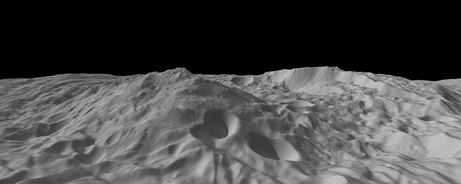
Oblique View of Vesta's South Polar Region - Rheasilvia. This image of the asteroid Vesta, calculated from a shape model, shows a tilted view of the topography of the south polar region. The image has a resolution of about 1,000 feet (300 meters) per pixel, and the vertical scale is 1.5 times that of the horizontal scale. Credit: NASA/JPL-Caltech/UCLA/MPS/DLR/IDA/PSI
[/caption]
NASA has just released an amazing new view of the mysterious south pole of Vesta that offers an oblique perspective view of the central mountain peak which is three times as high as Mt Everest. This topographic view , shown above,is completely unique to viewers from Earth and is provided courtesy of NASA’s exotic Dawn Asteroid Orbiter – newly arrived in July 2011.
The mountain peak rises about 15 miles (22 km) above the average height of the surrounding pockmarked terrain at Vesta’s south polar region – formally named Rheasilvia – and is located in the foreground, left side of the new image. A portion of the crater rim with a rather steep slope – known as a scarp – is seen at the right and may show evidence of Vestan landslides.
This oblique image derived from the on board Framing Camera was created from a shape model of the 530 km diameter asteroid. It has been flattened to remove the curvature of Vesta and has a vertical scale adjusted to 1.5 times that of the horizontal scale.
The origin of Vesta’s south polar region is hotly debated among the mission’s science team who will reveal their current theories at a briefing set for October 12 – watch for my upcoming report.
Dawn will remain in orbit at Vesta for 1 year until July 2012 and then fire up its revolutionary ion propulsion system to depart for Ceres, the largest Asteroid in the main belt between Mars and Jupiter.
Asteroid Vesta from Dawn
NASA's Dawn spacecraft obtained this image of the giant asteroid Vesta with its framing camera on July 24, 2011. It was taken from a distance of about 3,200 miles (5,200 kilometers). Dawn entered orbit around Vesta on July 15, and will spend a year orbiting the body. Credit: NASA/JPL-Caltech/UCLA/MPS/DLR/IDA
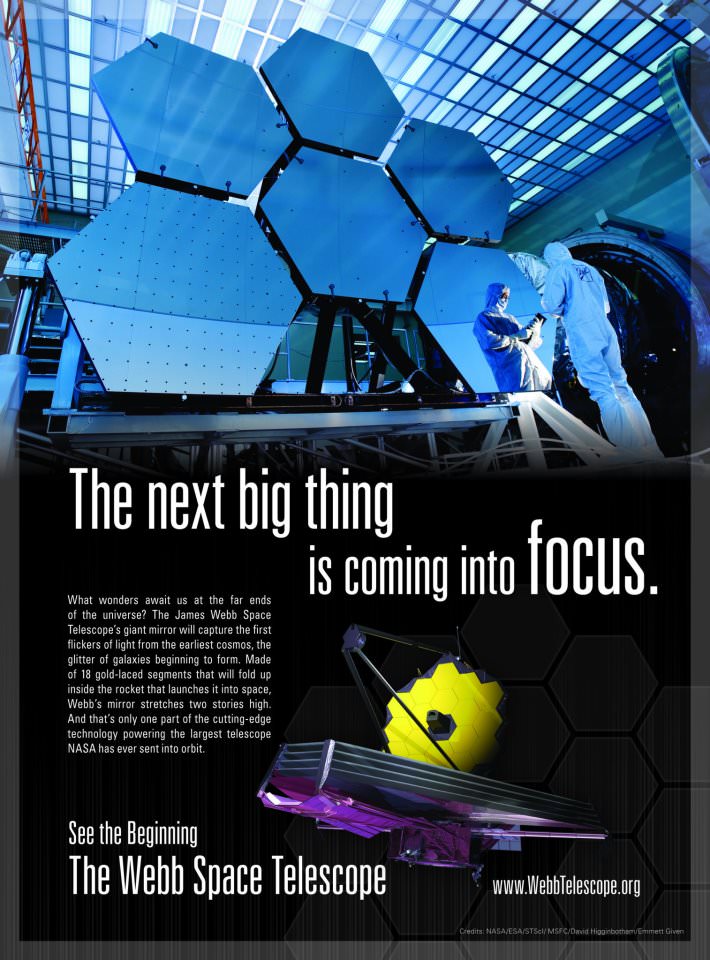
Do you love astronomy? Do you appreciate science? Do you have a curiosity about the nature of our Universe, how it came to be and what our place is within it? If you are even reading this I assume your answers to all of those questions is a resounding “yes!” and so I present to you an excellent video created by Brad Goodspeed in support of the James Webb Space Telescope:
“I made Vision because I thought the argument for science could benefit from a passionate delivery,” Brad told Universe Today. “Deep down we’re all moved by the stars, and that passion needs to be expressed by methods outside of science’s typical toolbox.”
[/caption]
Funding for this next-generation telescope is currently on the line in Washington. While a markup bill was passed last month by the House of Representatives that allows for continued funding of the JWST through to launch, it has not yet been ratified by Congress. It’s still very important to maintain support for the JWST by contacting your state representatives and letting them know that the future of space exploration is of concern to you.
A petition against the defunding of the JWST is currently active on Change.org and needs your signature (if you haven’t signed it already.) Signing ends at midnight tonight so be sure to click here to sign and pass it along as well! (You can share this shortened link on Twitter, Facebook, etc.: http://chn.ge/oy4ibI)
The JWST will be the premier observatory of the next decade, serving thousands of astronomers worldwide. It will study every phase in the history of our Universe, ranging from the first luminous glows after the Big Bang, to the formation of solar systems capable of supporting life on planets like Earth, to the evolution of our own Solar System. It is currently aiming for a 2018 launch date.
“We don’t get to the future by yielding to our most current fears… by being shortsighted.”