Host: Fraser Cain
Astrojournalists: Morgan Rehnberg, David Dickinson, Elizabeth Howell, Jason Major, Casey Dreier, Mike Simmons
Continue reading “Weekly Space Hangout – February 28, 2014: Good NASA News and 715 Confirmed Planets!”
Next Generation NASA/JAXA Global Weather Research Satellite thunders aloft from Japanese Spaceport
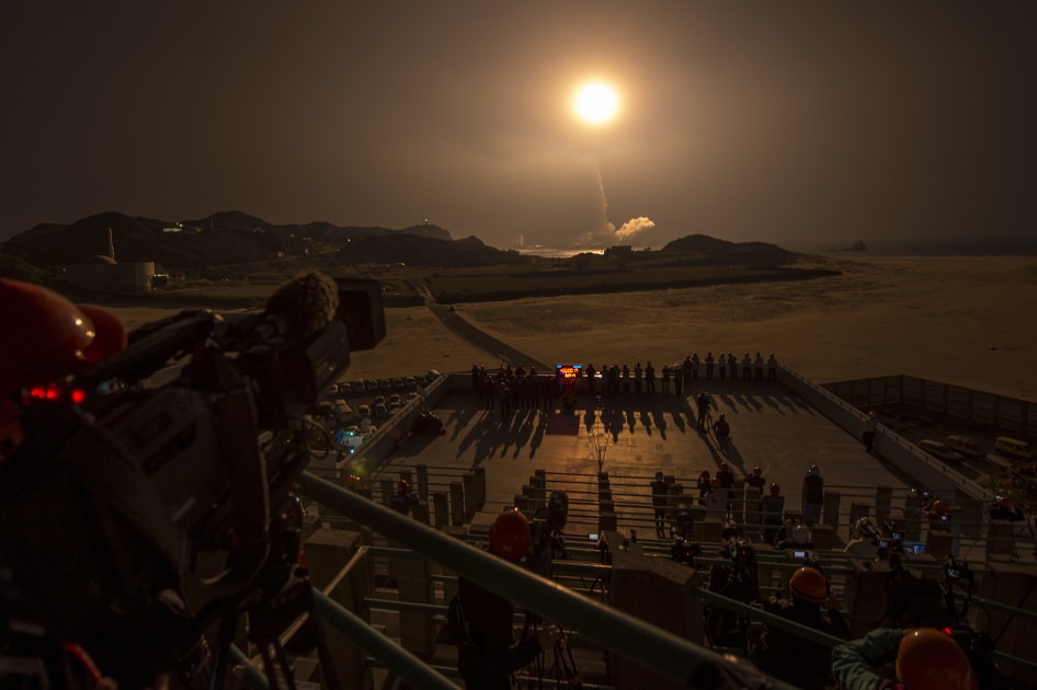
GPM Launch Seen From the Tanegashima Space Center
A Japanese H-IIA rocket with the NASA-Japan Aerospace Exploration Agency (JAXA), Global Precipitation Measurement (GPM) Core Observatory onboard, is seen launching from the Tanegashima Space Center on Friday, Feb. 28, 2014 (Japan Time), in Tanegashima, Japan; Thursday, Feb. 27, EST. Credit: NASA/Bill Ingalls[/caption]
NASA GODDARD SPACE FLIGHT CENTER, MARYLAND – A powerful, next generation weather observatory aimed at gathering unprecedented 3-D measurements of global rain and snowfall rates – and jointly developed by the US and Japan – thundered to orbit today (Feb. 27 EST, Feb. 28 JST) ) during a spectacular night time blastoff from a Japanese space port.
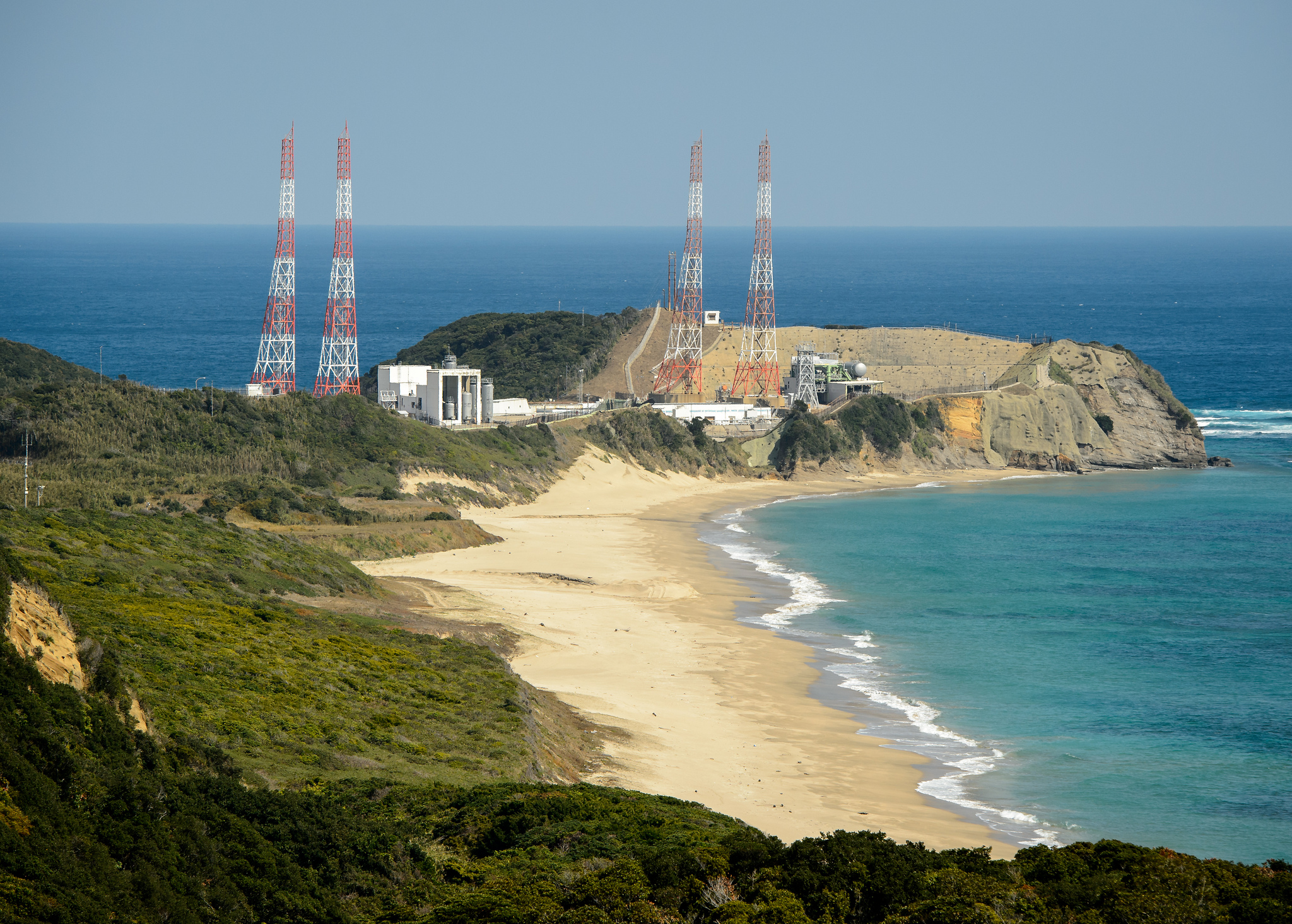
The Global Precipitation Measurement (GPM) Core Observatory was launched precisely on time at 1:37 p.m. EST, 1837 GMT, Thursday, Feb. 27 (3:37 a.m. JST Friday, Feb. 28) atop a Mitsubishi Heavy Industries H-IIA rocket from the Tanegashima Space Center on Tanegashima Island off southern Japan.
Viewers could watch the spectacular liftoff live on NASA TV – which was streamed here at Universe Today.
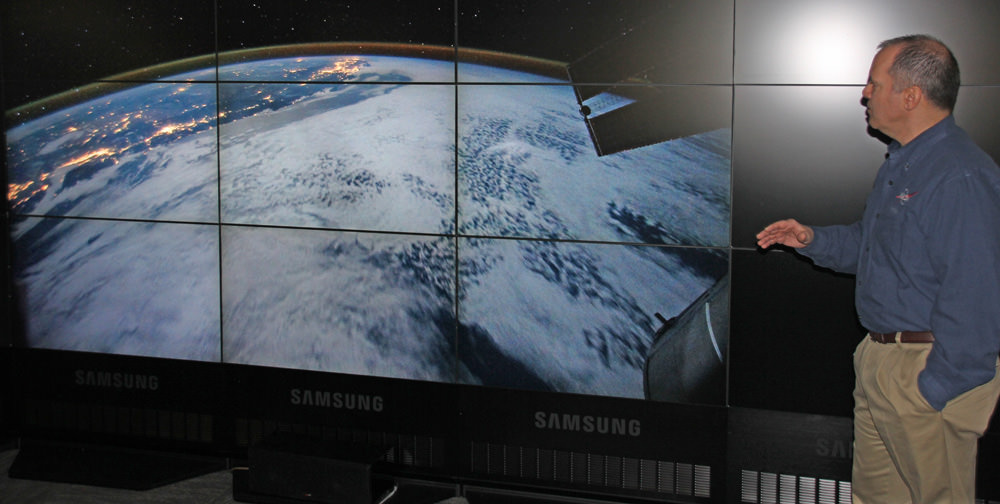
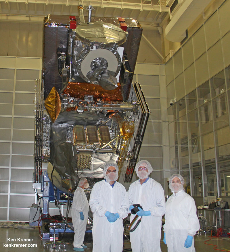
“GPM’s precipitation measurements will look like a CAT scan,” Dr. Dalia Kirschbaum, GPM research scientist, told me during a prelaunch interview with the GPM satellite in the cleanroom at NASA’s Goddard Space Flight Center in Greenbelt, Md.
“The radar can scan through clouds to create a three dimensional view of a clouds structure and evolution.”

GPM is the lead observatory of a constellation of nine highly advanced Earth orbiting weather research satellites contributed by the US, Japan, Europe and India.
Indeed GPM will be the first satellite to measure light rainfall and snow, in addition to heavy tropical rainfall.
It will collect a treasure trove of data enabling the most comprehensive measurements ever of global precipitation every three hours – and across a wide swath of the planet where virtually all of humanity lives from 65 N to 65 S latitudes.
GPM orbits at an altitude of 253 miles (407 kilometers) above Earth – quite similar to the International Space Station (ISS).
The global precipitation data will be made freely available to climate researchers and weather forecasters worldwide in near real time – something long awaited and not possible until now.
Water and the associated water and energy cycles are the basis of all life on Earth.
Yet scientists lack a clear and comprehensive understanding of key rain and snow fall amounts on most of the globe – which is at the heart of humanity’s existence and future well being on the home planet.
Having an accurate catalog of the water and energy cycles will direct benefit society and impact people’s lives on a daily basis with improved weather forecasts, more advanced warnings of extreme weather conditions, aid farmers, help identify and determine the effects of global climate change.
Researchers will use the GPM measurements to study climate change, freshwater resources, floods and droughts, and hurricane formation and tracking.
“With this launch, we have taken another giant leap in providing the world with an unprecedented picture of our planet’s rain and snow,” said NASA Administrator Charles Bolden, in a NASA statement.
 “GPM will help us better understand our ever-changing climate, improve forecasts of extreme weather events like floods, and assist decision makers around the world to better manage water resources.”
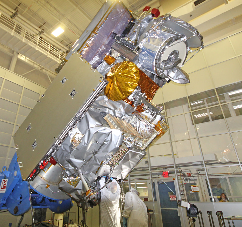
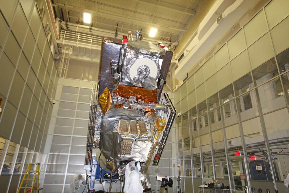
“The GPM spacecraft has been under development for a dozen years,” said GPM Project Manager Art Azarbarzin of NASA’s Goddard Space Flight Center in Greenbelt, Md., in a prelaunch interview with Universe Today conducted inside the clean room with GPM before it’s shipment to Japan.
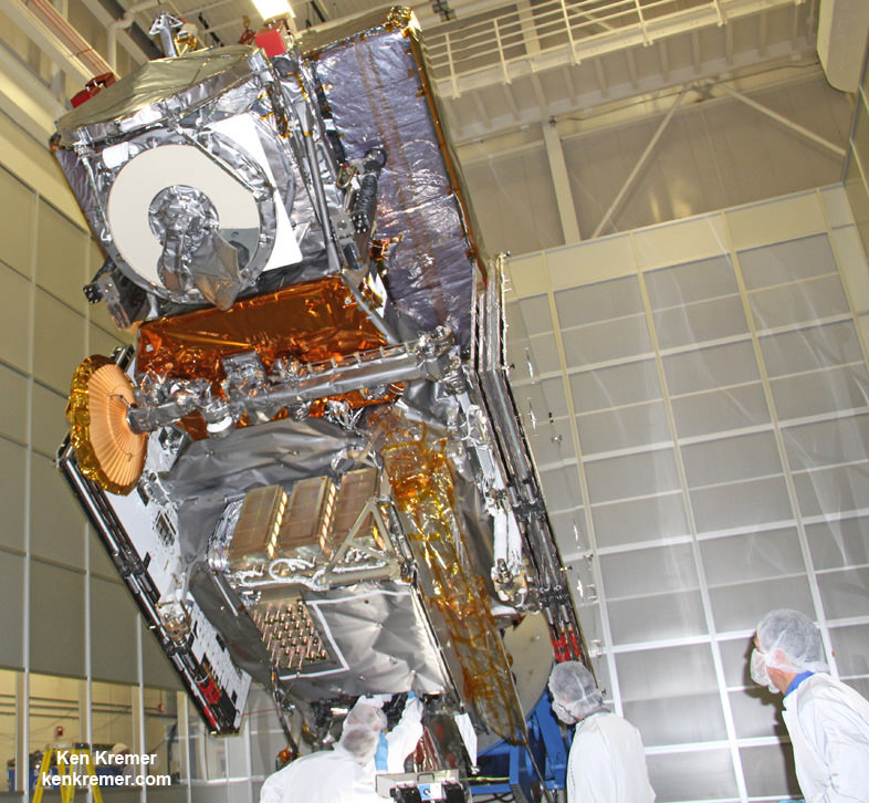
“The GPM satellite was built in house by the dedicated team at NASA’s Goddard Space Flight Center in Maryland,” Azarbarzin told me.
“It’s the largest satellite ever built at Goddard.”
Following the flawless blastoff, the nearly four ton GPM spacecraft separated from the Japanese rocket some 16 minutes later at an altitude of 247 miles (398 kilometers).
10 minutes later both of the spacecrafts life giving solar arrays deployed as planned.
“It is incredibly exciting to see this spacecraft launch,” said Azarbarzin, in a NASA statement. He witnessed the launch in Japan.
“This is the moment that the GPM Team has been working toward since 2006.”
“The GPM Core Observatory is the product of a dedicated team at Goddard, JAXA and others worldwide.”
“Soon, as GPM begins to collect precipitation observations, we’ll see these instruments at work providing real-time information for the scientists about the intensification of storms, rainfall in remote areas and so much more.”
The $933 Million observatory is a joint venture between the US and Japanese space agencies, NASA and the Japan Aerospace Exploration Agency (JAXA).
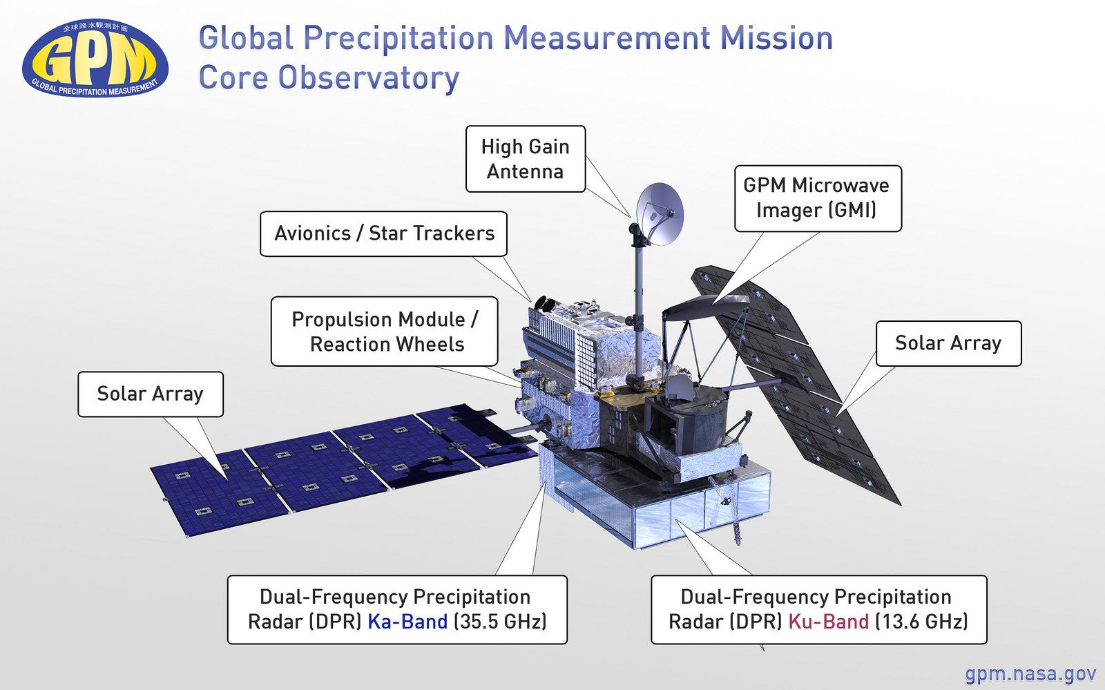
The 3850 kilogram GPM satellite is equipped with two instruments – an advanced, higher resolution dual -frequency precipitation (DPR) radar instrument (Ku and Ka band) built by JAXA in Japan and the GPM microwave imager (GMI) built by Ball Aerospace in the US.
The GPM observatory will replace the aging NASA/JAXA Tropical Rainfall Measuring Mission (TRMM) satellite launched back in 1997 and also jointly developed by NASA and JAXA.
“GPM is the direct follow-up to the currently orbiting TRMM satellite,” Azarbarzin explained to me.
“TRMM is reaching the end of its usable lifetime. After GPM launches we hope it has some overlap with observations from TRMM.”
GPM is vital to continuing the TRMM measurements. It will help provide improved forecasts and advance warning of extreme super storms like Hurricane Sandy and Super Typhoon Haiyan.
“TRMM was only designed to last three years but is still operating today. We hope GPM has a similar long life,” said Azarbarzin.
Stay tuned here for Ken’s continuing GPM reports and on-site coverage at NASA Goddard Space Flight Center in Maryland.
And watch for Ken’s continuing planetary and human spaceflight news about Curiosity, Opportunity, Chang’e-3, SpaceX, Orbital Sciences, LADEE, MAVEN, MOM, Mars, Orion and more.

NASA/JAXA Precipitation Measurement Satellite ‘GO’ for Feb. 27 Launch – Watch Live Here on NASA TV
Visualization of the GPM Core Observatory and Partner Satellites. GPM is slated to launch on Feb. 27 from Japan. Credit: NASA
See launch animation, Shinto ceremony, Rocket roll out and more below[/caption]
NASA GODDARD SPACE FLIGHT CENTER, MARYLAND – Blastoff of the powerful and revolutionary new NASA/JAXA rain and snow precipitation measurement satellite atop a Japanese rocket from a tiny offshore island launch pad is now less than 24 hours away on Thursday, Feb. 27, EST (Feb. 28 JST).
The Global Precipitation Measurement (GPM) Core Observatory aimed at improving forecasts of extreme weather and climate change research has been given a green light for launch atop a Mitsubishi Heavy Industries H-IIA rocket from the Tanegashima Space Center on Tanegashima Island off southern Japan.
Roll out of the H-IIA launch vehicle from the Vehicle Assembly Building is scheduled for this evening, Feb. 26 at 11 p.m. EST.
Update: rocket rolled out. Photo below, plus watch streaming NASA TV below.
Following the Launch Readiness Review, mission managers approved the GO for liftoff.

Japanese team members also prayed at a Shinto ceremony for blessings for a successful launch at the Ebisu Shrine, the first shrine in a traditional San-ja Mairi, or Three Shrine Pilgrimage on Tuesday, Feb. 25, 2014 – see photo below.
However, the team also set a newly revised launch time of 1:37 p.m. EST (18:37 UTC, and Feb. 28 at 3:37 a.m. JST).
Live streaming video by Ustream
Mission managers adjusted the H-IIA launch time after concerns raised by a collision avoidance analysis between the GPM spacecraft and the International Space Station (ISS).

GPM will fly at an altitude of 253 miles (407 kilometers) above Earth – quite similar to the ISS.
It’s coverage runs over virtually the entire populated globe from 65 N to 65 S latitudes.
NASA plans live coverage of the launch on Feb. 27 beginning at 12 noon EST on NASA Television.
It will be streamed live at: http://www.nasa.gov/nasatv
The $933 Million observatory is a joint venture between the US and Japanese space agencies, NASA and the Japan Aerospace Exploration Agency (JAXA).
GPM has a one-hour launch window. In case of any delays, the team will be required to conduct a thorough new collision avoidance analysis to ensure safety.
Weather forecast is excellent at this time.
Watch this GPM Launch animation:
Video caption: NASA/JAXA GPM Core Observatory Launch Animation
GPM is a next-generation satellite that will provide global, near real time observations of rain and snow from space. Such data is long awaited by climate scientists and weather forecasters.
It will open a new revolutionary era in global weather observing and climate science. Therefore it will have a direct impact on society and people’s daily lives worldwide.
The mission will significantly advance our understanding of Earth’s water and energy cycles and improve forecasting of extreme weather events.
The 3850 kilogram GPM satellite is equipped with two instruments – an advanced, higher resolution dual -frequency precipitation (DPR) radar instrument (Ku and Ka band) built by JAXA in Japan and the GPM microwave imager (GMI) built by Ball Aerospace in the US.
“The GPM satellite was built in house at NASA’s Goddard Space Flight Center in Maryland,” Art Azarbarzin, GPM project manager, told Universe Today during my exclusive up-close clean room inspection tour of the huge satellite as final processing was underway.
Researchers will use the GPM measurements to study climate change, freshwater resources, floods and droughts, and hurricane formation and tracking.
“GPM will join a worldwide constellation of current and planned satellites,” Azarbarzin told me during an interview in the Goddard cleanroom beside GPM.
“GPM is the direct follow-up to the currently orbiting TRMM satellite,” Azarbarzin explained.
“TRMM is reaching the end of its usable lifetime. After GPM launches we hope it has some overlap with observations from TRMM.”
“The Global Precipitation Measurement (GPM) observatory will provide high resolution global measurements of rain and snow every 3 hours,” Dalia Kirschbaum, GPM research scientist, told me during an interview at Goddard.
Stay tuned here for Ken’s continuing GPM reports and on-site coverage at NASA Goddard Space Flight Center in Maryland.
And watch for Ken’s continuing planetary and human spaceflight news about Curiosity, Opportunity, Chang’e-3, SpaceX, Orbital Sciences, LADEE, MAVEN, MOM, Mars, Orion and more.

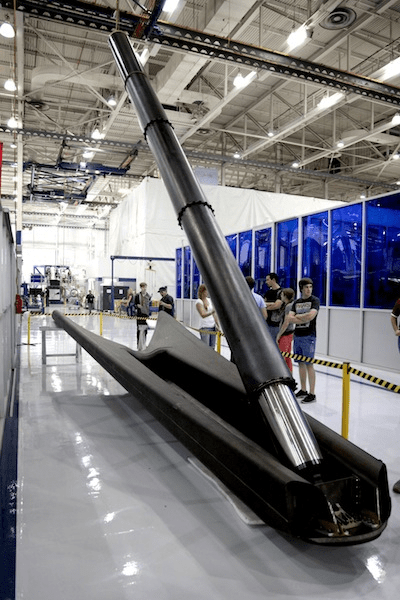
Next SpaceX Falcon 9 Rocket Gets Landing Legs for March Blastoff to Space Station – Says Elon Musk

1st stage of SpaceX Falcon 9 rocket newly equipped with landing legs and now scheduled for launch to the International Space Station on March 16, 2014 from Cape Canaveral, FL. Credit: SpaceX/Elon Musk
Story updated[/caption]
The next commercial SpaceX Falcon 9 rocket that’s set to launch in March carrying an unmanned Dragon cargo vessel will also be equipped with a quartet of landing legs in a key test that will one day lead to cheaper, reusable boosters, announced Elon Musk, the company’s founder and CEO.
The attachment of landing legs to the first stage of SpaceX’s new and more powerful, next-generation Falcon 9 rocket counts as a major step towards the firm’s eventual goal of building a fully reusable rocket.
Before attempting the use of landing legs “SpaceX needed to gain more confidence” in the new Falcon 9 rocket, Musk told me in an earlier interview.
Blastoff of the upgraded Falcon 9 on the Dragon CRS-3 flight is currently slated for March 16 from Cape Canaveral Air Force Station, Florida on a resupply mission to bring vital supplies to the International Space Station (ISS) in low Earth orbit for NASA.
“Mounting landing legs (~60 ft span) to Falcon 9 for next month’s Space Station servicing flight,” Musk tweeted, along with the up close photos above and below.
“SpaceX believes a fully and rapidly reusable rocket is the pivotal breakthrough needed to substantially reduce the cost of space access,” according to the firm’s website.
SpaceX hopes to vastly reduce their already low $54 million launch cost when a reusable version of the Falcon 9 becomes feasible.
Although this Falcon 9 will be sprouting legs, a controlled soft landing in the Atlantic Ocean guided by SpaceX engineers is still planned for this trip.
“However, F9 will continue to land in the ocean until we prove precision control from hypersonic thru subsonic regimes,” Musk quickly added in a follow-up twitter message.
In a prior interview, I asked Elon Musk when a Falcon 9 flyback would be attempted?
“It will be on one of the upcoming missions to follow [the SES-8 launch],” Musk told me.
“What we need to do is gain more confidence on the three sigma dispersion of the mission performance of the rocket related to parameters such as thrust, specific impulse, steering loss and a whole bunch of other parameters that can impact the mission.”
“If all of those parameters combine in a negative way then you can fall short of the mission performance,” Musk explained to Universe Today.
When the upgraded Falcon 9 performed flawlessly for the SES-8 satellite launch on Dec 3, 2013 and the Thaicom-6 launch on Jan. 6, 2014, the path became clear to attempt the use of landing legs on this upcoming CRS-3 launch this March.
Atmospheric reentry engineering data was gathered during those last two Falcon 9 launches to feed into SpaceX’s future launch planning, Musk said.
That new data collected on the booster stage has now enabled the approval for landing leg utilization in this March 16 flight.
SpaceX engineers will continue to develop and refine the technology needed to accomplish a successful touchdown by the landing legs on solid ground back at the Cape in Florida.
Extensive work and testing remains before a land landing will be attempted by the company.
Ocean recovery teams will retrieve the 1st stage and haul it back to port much like the Space Shuttle’s pair of Solid Rocket Boosters.
This will be the second attempt at a water soft landing with the upgraded Falcon 9 booster.

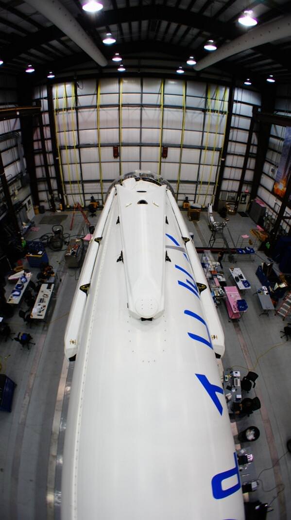
The two stage Falcon 9 rocket and Dragon cargo carrier are currently in the final stages of processing by SpaceX technicians for the planned March 16 night time liftoff from Space Launch Complex 40 at 4:41 a.m. that will turn night into day along the Florida Space Coast.
“All four landing legs now mounted on Falcon 9,” Musk tweeted today, Feb. 25.
SpaceX has carried out extensive landing leg and free flight tests of ever increasing complexity and duration with the Grasshopper reusable pathfinding prototype.
SpaceX is under contract to NASA to deliver 20,000 kg (44,000) pounds of cargo to the ISS during a dozen Dragon cargo spacecraft flights over the next few years at a cost of about $1.6 Billion.
To date SpaceX has completed two cargo resupply missions. The last flight dubbed CRS-2 blasted off a year ago on March 1, 2013.
The Falcon 9 and Dragon were privately developed by SpaceX with seed money from NASA in a public-private partnership.
The goal was to restore the cargo up mass capability the US completely lost following the retirement of NASA’s space shuttle orbiters in 2011.
SpaceX along with Orbital Sciences Corp are both partnered with NASA’s Commercial Resupply Services program.
Orbital Sciences developed the competing Antares rocket and Cygnus cargo spacecraft.
This extra powerful new version of the Falcon 9 dubbed v1.1 is powered by a cluster of nine of SpaceX’s new Merlin 1D engines that are about 50% more powerful compared to the standard Merlin 1C engines. The nine Merlin 1D engines 1.3 million pounds of thrust at sea level rises to 1.5 million pounds as the rocket climbs to orbit.
The Merlin 1 D engines are arrayed in an octaweb layout for improved efficiency.

Therefore the upgraded Falcon 9 can boost a much heavier cargo load to the ISS, low Earth orbit, geostationary orbit and beyond.
The next generation Falcon 9 is a monster. It measures 224 feet tall and is 12 feet in diameter. That compares to a 130 foot tall rocket for the original Falcon 9.
Stay tuned here for Ken’s continuing SpaceX, Orbital Sciences, commercial space, Orion, Chang’e-3, LADEE, Mars rover, MAVEN, MOM and more planetary and human spaceflight news – and upcoming launch coverage at Cape Canaveral & the Kennedy Space Center press site.

Yutu Moon Rover Starts 3rd Night Time Hibernation But Technical Problems Persist
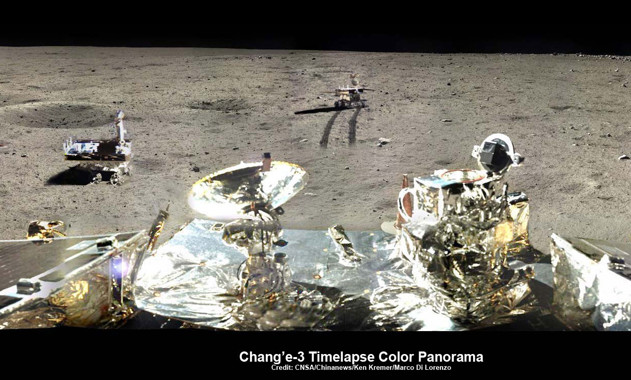
Chang’e-3/Yutu Timelapse Color Panorama
This newly expanded timelapse composite view shows China’s Yutu moon rover at two positions passing by crater and heading south and away from the Chang’e-3 landing site forever about a week after the Dec. 14, 2013 touchdown at Mare Imbrium. This cropped view was taken from the 360-degree timelapse panorama. See complete 360 degree landing site timelapse panorama herein and APOD Feb. 3, 2014. . Chang’e-3 landers extreme ultraviolet (EUV) camera is at right, antenna at left. Credit: CNSA/Chinanews/Ken Kremer/Marco Di Lorenzo – kenkremer.com.
See our complete Yutu timelapse pano at NASA APOD Feb. 3, 2014: http://apod.nasa.gov/apod/ap140203.htm
Story updated[/caption]
The world famous and hugely popular ‘Yutu’ rover entered its 3rd Lunar night time hibernation period this weekend as planned, but serious technical troubles persist that are hampering science operations Chinese space managers confirmed.
“China’s lunar rover Yutu entered its third planned dormancy on Saturday, with the mechanical control issues that might cripple the vehicle still unresolved,” reports Xinhua, China’s official government news agency, in a mission status update newly released today (Feb. 23).
Yutu went to sleep on Saturday afternoon, Feb. 22, local Beijing time, according to China’s State Administration of Science, Technology and Industry for National Defence (SASTIND), responsible for the mission.
The companion Chang’e-3 lunar lander entered hibernation soon thereafter early today, Sunday, Feb 23.
See our new lunar panoramas by Ken Kremer and Marco Di Lorenzo herein and at NASA APOD on Feb. 3, 2014.

This new 360-degree time-lapse color panorama from China’s Chang’e-3 lander shows the Yutu rover at five different positions, including passing by crater and heading south and away from the Chang’e-3 lunar landing site forever during its trek over the Moon’s surface at its landing site from Dec. 15-22, 2013 during the 1st Lunar Day. Credit: CNSA/Chinanews/Ken Kremer/Marco Di Lorenzo – kenkremer.com. See our Yutu timelapse pano at NASA APOD Feb. 3, 2014: http://apod.nasa.gov/apod/ap140203.htm
Yutu first encountered a serious technical malfunction a month ago on Jan. 25, when she suffered ‘a mechanical control anomoly’ just prior to entering hibernation for the duration of Lunar Night 2.
The abnormality occurred due to the “complicated lunar surface,” according to SASTIND.

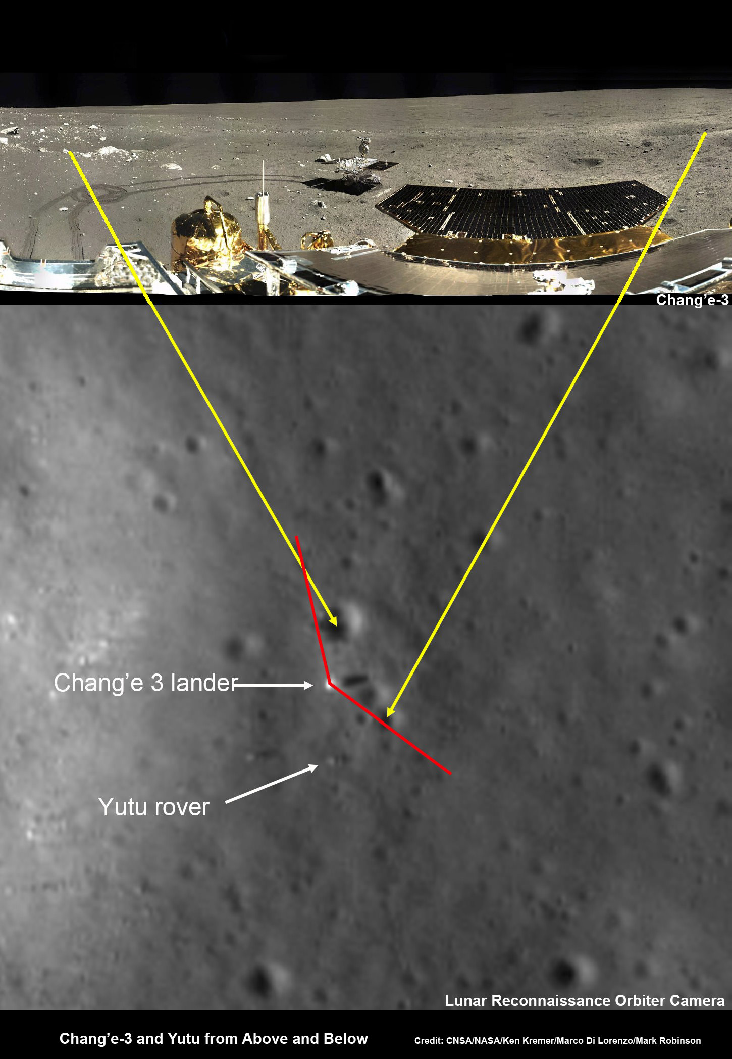
New mosaic of the Chang’e-3 moon lander and the lunar surface taken by the camera on China’s Yutu moon rover from a position south of the lander. Note the landing ramp and rover tracks at left. Credit: CNSA/SASTIND/Xinhua/Marco Di Lorenzo/Ken Kremer – kenkremer.com
Chinese space officials have not divulged the exact nature of the problems. And they have not released any details of the efforts to resolve the issues that “might cripple the vehicle.”
Since both Chinese Moon probes are solar powered, they must power down and enter a dormant mode during every two week long lunar night period when there is no sunlight to generate energy from their solar arrays. And no communications with Earth are possible.
The rover, nicknamed ‘Jade Rabbit’ remained stationary during the just concluded two week long lunar day time period, said SASTIND. It was unable to move due to the mechanical glitches.
“Yutu only carried out fixed point observations during its third lunar day.”
But it did complete some limited scientific observations. And fortunately the ground penetrating radar, panoramic and infrared imaging equipment are functioning normally.

The six wheel robot’s future was placed in jeopardy after it suffered the “mechanical anomaly” in late January 2014 and then awoke later than the scheduled time on Feb. 10, at the start of its 3rd Lunar Day.
To the teams enormous relief, a signal was finally detected.
“Yutu has come back to life!” said Pei Zhaoyu, the spokesperson for China’s lunar probe program, according to a Feb. 12 news report by the state owned Xinhua news agency.
“Experts are still working to verify the causes of its mechanical control abnormality.”
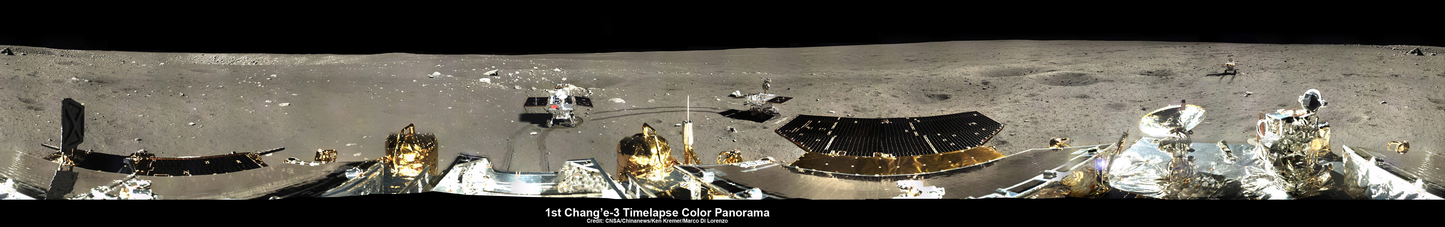
This 360-degree time-lapse color panorama from China’s Chang’e-3 lander shows the Yutu rover at three different positions during its trek over the Moon’s surface at its landing site from Dec. 15-22, 2013 during the 1st Lunar Day. Credit: CNSA/Chinanews/Ken Kremer/Marco Di Lorenzo – kenkremer.com. See our Yutu timelapse pano at NASA APOD Feb. 3, 2014: http://apod.nasa.gov/apod/ap140203.htm
Since then, Chinese space engineers sought to troubleshoot the technical problems and were in a race against time to find a solution before the start of Lunar Night 3 this weekend.
“Experts had feared that it might never function again, but Yutu “woke up” on Feb. 12, two days behind schedule,” reported Xinhua.
Each lunar day and night lasts for alternating periods of 14 Earth days.
During each long night, the Moon’s temperatures plunge dramatically to below minus 180 Celsius, or minus 292 degrees Fahrenheit.
Both solar powered probes must enter hibernation mode during each lunar night to conserve energy and protect their science instruments and control mechanisms, computers and electronics.
“Scientists are still trying to find a fix for the abnormalities,” said CCTV, China’s official state television network.
So Yutu is now sleeping with the problems unresolved and no one knows what the future holds.
Hopefully Jade Rabbit awakes again in about two weeks time to see the start of Lunar Day 4.
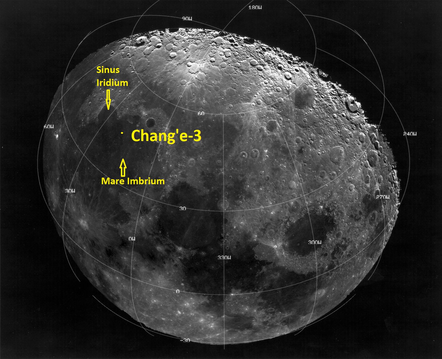
The Chang’e-3 mothership lander and piggybacked Yutu surface rover soft landed on the Moon on Dec. 14, 2013 at Mare Imbrium (Sea of Rains) – marking China’s first successful spacecraft landings on an extraterrestrial body in history.

‘Jade Rabbit’ had departed the landing site forever, and was journeying southwards as the anomoly occurred – about six weeks into its planned 3 month long moon roving expedition to investigate the moon’s surface composition and natural resources.
The 140 kg Yutu robot is located some 100 m south of the lander.
The 1200 kg stationary lander is expected to return science data about the Moon and conduct telescopic observations of the Earth and celestial objects for at least one year.
Chang’e-3 and Yutu landed on a thick deposit of volcanic material.
China is only the 3rd country in the world to successfully soft land a spacecraft on Earth’s nearest neighbor after the United States and the Soviet Union.
Stay tuned here for Ken’s continuing Chang’e-3, Orion, Orbital Sciences, SpaceX, commercial space, LADEE, Mars and more planetary and human spaceflight news.

Powerful New Next-Gen US/Japan GPM Satellite to Revolutionize Global Precipitation Observations and Climate Science Research
NASA GODDARD SPACE FLIGHT CENTER, MARYLAND – Weather researchers and forecasters worldwide are gushing with excitement in the final days leading to blastoff of the powerful, new Global Precipitation Measurement (GPM) Core Observatory – built by NASA in a joint effort with Japan.
GPM is a next-generation satellite that will provide global, near real time observations of rain and snow from space and thereby open a new revolutionary era in global weather observing and climate science. Therefore it will have a direct impact on society and people’s daily lives worldwide.
The team is counting down to liftoff in less than 5 days, on Feb. 27 at 1:07 PM EST from the Tanegashima Space Center, on Tanegashima Island off southern Japan, atop the highly reliable Mitsubishi Heavy Industries H-IIA rocket.
The GPM launch to low Earth orbit was delayed by both natural and manmade disasters – namely the 2011 Fukushima earthquake in Japan as well as the ridiculous US government shutdown in Oct. 2013. That’s the same foolish shutdown that also delayed NASA’s new MAVEN Mars orbiter and numerous other US space & science projects.

The $933 Million mission is a joint venture between NASA and the Japan Aerospace Exploration Agency (JAXA), Japan’s space agency.
The mission will significantly advance our understanding of Earth’s water and energy cycles and improve forecasting of extreme weather events.
It is equipped with an advanced, higher resolution dual -frequency precipitation (DPR) radar instrument (Ku and Ka band) built by JAXA in Japan and the GPM microwave imager (GMI) built by Ball Aerospace in the US.
“The GPM satellite was built in house at NASA’s Goddard Space Flight Center in Maryland,” Art Azarbarzin, GPM project manager, told Universe Today during my exclusive up-close clean room inspection tour of the huge satellite as final processing was underway.
Shortly after my tour of GPM, the 3850 kilogram satellite was carefully packed up for shipment to the Japanese launch site.
“GPM will join a worldwide constellation of current and planned satellites,” Azarbarzin told me during an interview in the Goddard cleanroom with GPM.
And the imminent launch to augment the existing satellite constellation can’t come soon enough, he noted.
The GPM observatory will replace the aging NASA/JAXA Tropical Rainfall Measuring Mission (TRMM), satellite launched back in 1997.
“GPM is the direct follow-up to the currently orbiting TRMM satellite,” Azarbarzin explained.
“TRMM is reaching the end of its usable lifetime. GPM launches on February 27, 2014 and we hope it has some overlap with observations from TRMM.”
“The Global Precipitation Measurement (GPM) observatory will provide high resolution global measurements of rain and snow every 3 hours,” Dalia Kirschbaum, GPM research scientist, told me during an interview at Goddard.
It is vital to continuing the TRMM measurements and will help provide improved forecasts and advance warning of extreme super storms like Hurricane Sandy and Super Typhoon Haiyan, Azarbarzin and Kirschbaum explained.
Researchers will use the GPM measurements to study climate change, freshwater resources, floods and droughts, and hurricane formation and tracking.
“The water-cycle, so familiar to all school-age young scientists, is one of the most interesting, dynamic, and important elements in our studies of the Earth’s weather and climate,” said John Grunsfeld, associate administrator for NASA’s Science Mission Directorate in Washington, in a statement.
“GPM will provide scientists and forecasters critical information to help us understand and cope with future extreme weather events and fresh water resources.”
NASA TV will carry the launch live with commentary starting at 12 Noon EST on Feb. 27.
Stay tuned here for Ken’s continuing GPM reports and onsite coverage at NASA Goddard Space Flight Center in Maryland.
And watch for Ken’s continuing planetary and human spaceflight news about Curiosity, Opportunity, Chang’e-3, SpaceX, Orbital Sciences, LADEE, MAVEN, MOM, Mars, Orion and more.
Runaway Star Shocks the Galaxy!

That might seem like a sensational headline worthy of a supermarket tabloid but, taken in context, it’s exactly what’s happening here!
The bright blue star at the center of this image is a B-type supergiant named Kappa Cassiopeiae, 4,000 light-years away. As stars in our galaxy go it’s pretty big — over 57 million kilometers wide, about 41 times the radius of the Sun. But its size isn’t what makes K Cas stand out — it’s the infrared-bright bow shock it’s creating as it speeds past its stellar neighbors at a breakneck 1,100 kilometers per second.
K Cas is what’s called a runway star. It’s traveling very fast in relation to the stars around it, possibly due to the supernova explosion of a previous nearby stellar neighbor or companion, or perhaps kicked into high gear during a close encounter with a massive object like a black hole.
As it speeds through the galaxy it creates a curved bow shock in front of it, like water rising up in front of the bow of a ship. This is the ionized glow of interstellar material compressed and heated by K Cas’ stellar wind. Although it looks like it surrounds the star pretty closely in the image above, the glowing shockwave is actually about 4 light-years out from K Cas… slightly less than the distance from the Sun to Proxima Centauri.
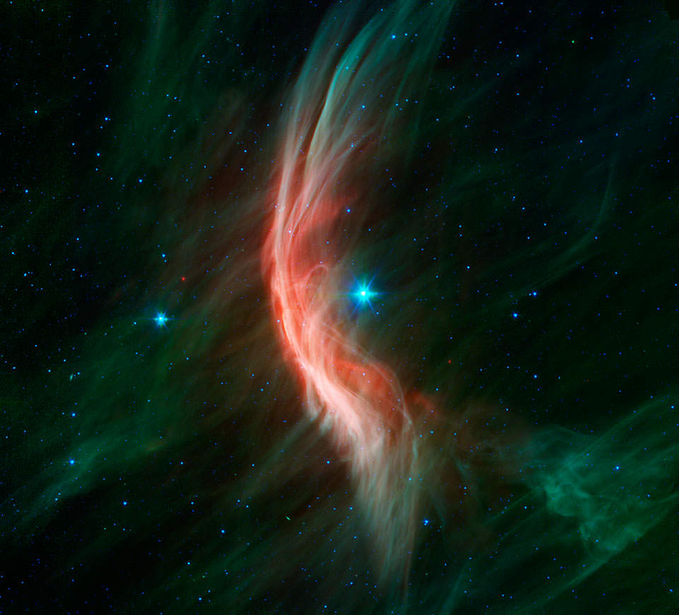
Although K Cas is visible to the naked eye, its bow shock isn’t. It’s only made apparent in infrared wavelengths, which NASA’s Spitzer Space Telescope is specifically designed to detect. Some other runaway stars have brighter bow shocks — like Zeta Ophiuchi at right — which can be seen in optical wavelengths (as long as they’re not obscured by dust, which Zeta Oph is.)
Related: Surprise! IBEX Finds No Bow ‘Shock’ Outside our Solar System
The bright wisps seen crossing K Cas’ bow shock may be magnetic filaments that run throughout the galaxy, made visible through interaction with the ionized gas. In fact bow shocks are of particular interest to astronomers precisely because they help reveal otherwise invisible features and allow deeper investigation into the chemical composition of stars and the regions of the galaxy they are traveling through. Like a speeding car on a dark country road, runaway stars’ bow shocks are — to scientists — like high-beam headlamps lighting up the space ahead.
Runaway stars are not to be confused with rogue stars, which, although also feel the need for speed, have been flung completely out of their home galaxies.
Source: NASA
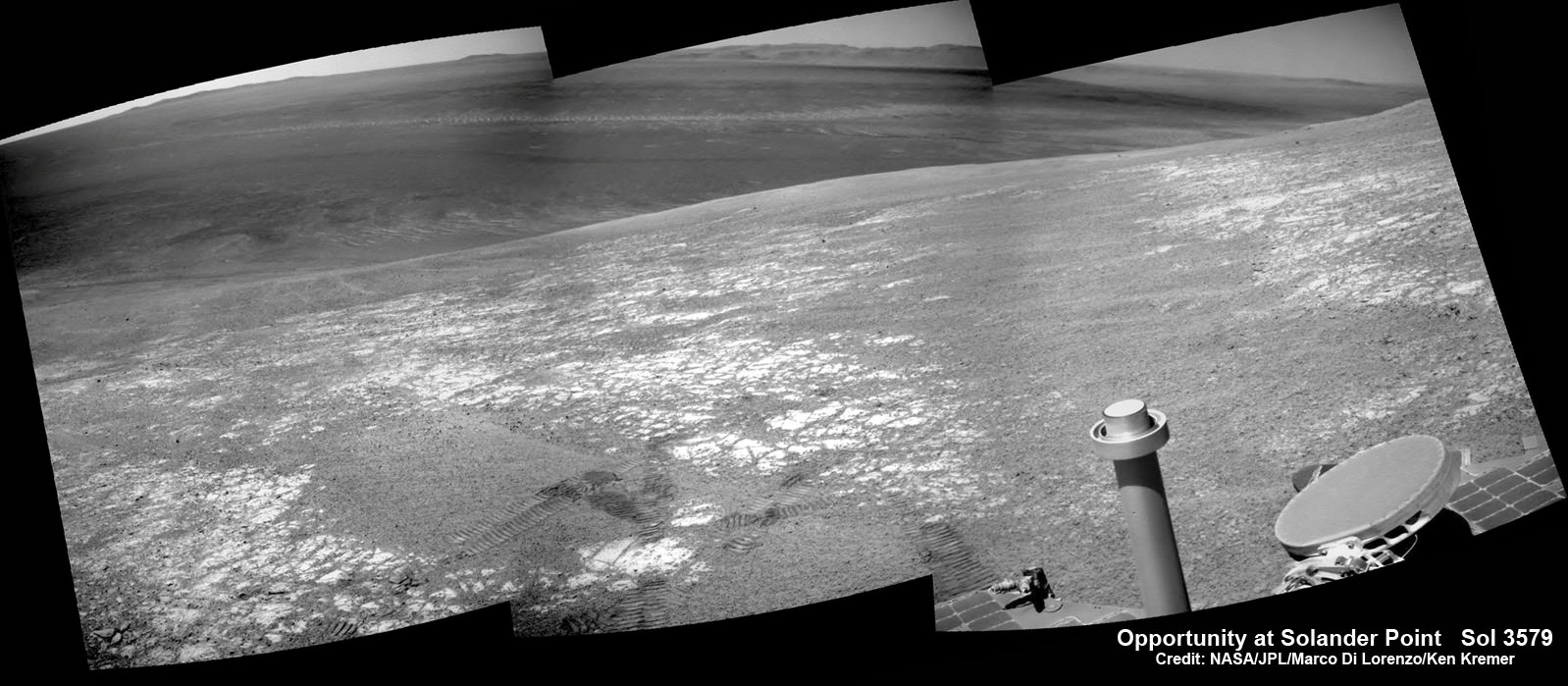
Martian Dune Buggy Curiosity Adopts New Driving Mode to Save Wheels from Rough Rocks
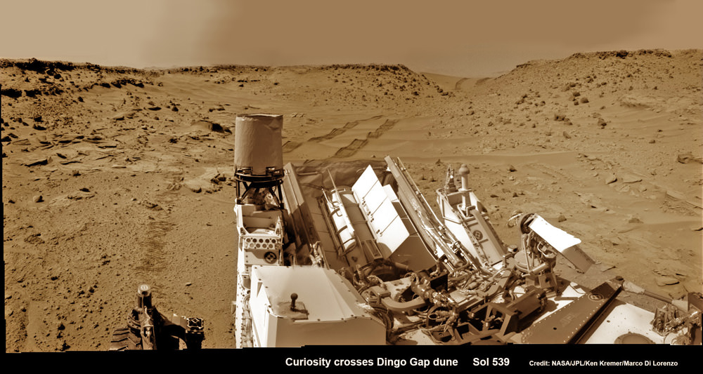
Curiosity looks back eastward to ‘Dingo Gap’ sand dune inside Gale Crater
After crossing over the 3 foot (1 meter) tall dune on Sol 539, Feb. 9, 2014 the rover drove westward into the ‘Moonlight Valley’. The parallel rover wheel tracks are 9 feet (2.7 meters) apart. Assembled from Sol 539 colorized navcam raw images. Credit: NASA/JPL/ Ken Kremer- kenkremer.com/Marco Di Lorenzo
See Dune and Wheel mosaics below – Story updated [/caption]
The team directing the epic trek of NASA’s Curiosity rover across the floor of Gale Crater has adopted new driving strategies and a new way forward in response to the unexpected wheel damage caused by driving over fields of rough edged Red Planet rocks in recent months.
This week, engineers directed dune buggy Curiosity to drive backwards for a lengthy distance over the Martian surface for the first time since landing.
The SUV sized vehicle apparently passed the reverse driving feasibility test with flying colors and is now well on the way to the exciting journey ahead aiming for the sedimentary layers at the base of towering Mount Sharp – the primary mission destination – which reaches 3.4 miles (5.5 km) into the Martian sky and possesses water altered minerals.
“We wanted to have backwards driving in our validated toolkit because there will be parts of our route that will be more challenging,” said Curiosity Project Manager Jim Erickson of NASA’s Jet Propulsion Laboratory, Pasadena, Calif, in a statement.
On Tuesday, Feb. 18, Curiosity not only drove in reverse, but the 329 feet (100.3 meters) distance covered marked her farthest one-day advance in over three months.
And she is also now roving over the much sought after smoother Martian terrain, as hoped, when the team decided to alter the traverse route based on high resolution imaging observations collected by the telescopic camera on NASA’s Mars Reconnaissance Orbiter (MRO) circling overhead.
The goal is to minimize wear and tear on the 20 inch diameter wheels.

Engineers were forced to devise new driving techniques and consider a new route forward after the aluminum wheels accumulated significant punctures and rips during the past few months of driving over fields strewn with sharp edged Martian rocks.
“We have changed our focus to look at the big picture for getting to the slopes of Mount Sharp, assessing different potential routes and different entry points to the destination area,” Erickson said.
“No route will be perfect; we need to figure out the best of the imperfect ones.”
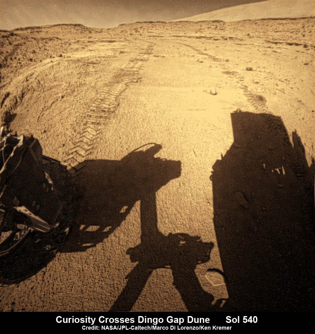
But to reach the smooth terrain and the science rich targets located on the pathway ahead, the six wheeled rover first had to pass through a gateway known as the ‘Dingo Gap’ sand dune.

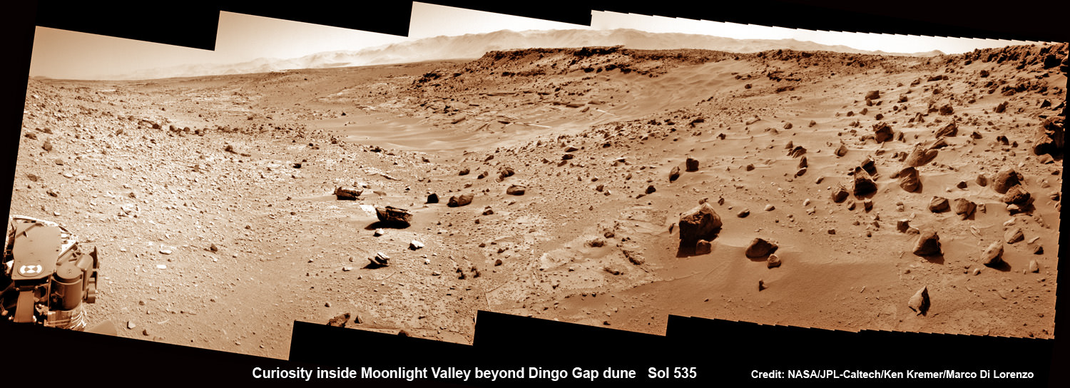
This photomosaic from Curiosity’s Navigation Camera (Navcam) taken at the edge of the entrance to the Dingo Gap shows a 3 foot (1 meter) tall dune and valley terrain beyond to the west, all dramatically back dropped by eroded rim of Gale Crater. View from the rover’s current position on Sol 528 (Jan. 30, 2014). The rover team may decide soon whether Curiosity will bridge the dune gap as a smoother path to next science destination. Credit: NASA/JPL-Caltech/Marco Di Lorenzo/Ken Kremer- kenkremer.com
“Moonlight Valley” is the name of the breathtaking new locale beyond Dingo, Curiosity Principal Investigator John Grotzinger, of Caltech, told Universe Today.
Curiosity crossed through the 3 foot (1 meter) tall Dingo Gap sand dune with ease on Feb. 9 and roved on to targets in the “Moonlight Valley” and the region beyond.
“Moonlight Valley has got lots of veins cutting through it,” Grotzinger told me.
“We’re seeing recessive bedrock.”
Since passing through the Dingo Gap gateway, Curiosity has traveled another 937 feet (285.5 meters) for a total mission odometry of 3.24 miles (5.21 kilometers) since the nail biting landing on Aug. 6, 2012.
“After we got over the dune, we began driving in terrain that looks like what we expected based on the orbital data. There are fewer sharp rocks, many of them are loose, and in most places there’s a little bit of sand cushioning the vehicle,” Erickson said.
Curiosity’s near term goal is to reach her next science waypoint, named Kimberly (formerly called KMS-9) which lies about two-thirds of a mile (about 1.1 kilometers) ahead.
Kimberly is of interest to the science team because it sits at an the intersection of different rock layers.
The 1 ton robot may be directed to drill into another rock at Kimberly.
If approved, Kimberly would be her first since drilling operation since boring into Cumberland rock target last spring and since departing the Yellowknife Bay region in July 2013 where she discovered a habitable zone.

To date Curiosity’s odometer stands at 5.2 kilometers and she has taken over 118,000 images. The robot has about another 5 km to go to reach the foothills of Mount Sharp.
Meanwhile, NASA’s sister Opportunity rover was just imaged from orbit by MRO while exploring clay mineral outcrops by the summit of Solander Point on the opposite side of Mars at the start of her 2nd Decade investigating the Red Planet’s mysteries.
And a pair of new orbiters are streaking to the Red Planet to fortify Earth’s invasion fleet- NASA’s MAVEN and India’s MOM.
Stay tuned here for Ken’s continuing Curiosity, Opportunity, Chang’e-3, SpaceX, Orbital Sciences, LADEE, MAVEN, MOM, Mars and more planetary and human spaceflight news.

Could Jupiter Become A Star?

NASA’s Galileo spacecraft arrived at Jupiter on December 7, 1995, and proceeded to study the giant planet for almost 8 years. It sent back a tremendous amount of scientific information that revolutionized our understanding of the Jovian system. By the end of its mission, Galileo was worn down. Instruments were failing and scientists were worried they wouldn’t be able to communicate with the spacecraft in the future. If they lost contact, Galileo would continue to orbit the Jupiter and potentially crash into one of its icy moons.
Galileo would certainly have Earth bacteria on board, which might contaminate the pristine environments of the Jovian moons, and so NASA decided it would be best to crash Galileo into Jupiter, removing the risk entirely. Although everyone in the scientific community were certain this was the safe and wise thing to do, there were a small group of people concerned that crashing Galileo into Jupiter, with its Plutonium thermal reactor, might cause a cascade reaction that would ignite Jupiter into a second star in the Solar System.
Hydrogen bombs are ignited by detonating plutonium, and Jupiter’s got a lot of hydrogen.Since we don’t have a second star, you’ll be glad to know this didn’t happen. Could it have happened? Could it ever happen? The answer, of course, is a series of nos. No, it couldn’t have happened. There’s no way it could ever happen… or is there?
Jupiter is mostly made of hydrogen, in order to turn it into a giant fireball you’d need oxygen to burn it. Water tells us what the recipe is. There are two atoms of hydrogen to one atom of oxygen. If you can get the two elements together in those quantities, you get water.
In other words, if you could surround Jupiter with half again more Jupiter’s worth of oxygen, you’d get a Jupiter plus a half sized fireball. It would turn into water and release energy. But that much oxygen isn’t handy, and even though it’s a giant ball of fire, that’s still not a star anyway. In fact, stars aren’t “burning” at all, at least, not in the combustion sense.
Our Sun produces its energy through fusion. The vast gravity compresses hydrogen down to the point that high pressure and temperatures cram hydrogen atoms into helium. This is a fusion reaction. It generates excess energy, and so the Sun is bright. And the only way you can get a reaction like this is when you bring together a massive amount of hydrogen. In fact… you’d need a star’s worth of hydrogen. Jupiter is a thousand times less massive than the Sun. One thousand times less massive. In other words, if you crashed 1000 Jupiters together, then we’d have a second actual Sun in our Solar System.
But the Sun isn’t the smallest possible star you can have. In fact, if you have about 7.5% the mass of the Sun’s worth of hydrogen collected together, you’ll get a red dwarf star. So the smallest red dwarf star is still about 80 times the mass of Jupiter. You know the drill, find 79 more Jupiters, crash them into Jupiter, and we’d have a second star in the Solar System.
There’s another object that’s less massive than a red dwarf, but it’s still sort of star like: a brown dwarf. This is an object which isn’t massive enough to ignite in true fusion, but it’s still massive enough that deuterium, a variant of hydrogen, will fuse. You can get a brown dwarf with only 13 times the mass of Jupiter. Now that’s not so hard, right? Find 13 more Jupiters, crash them into the planet?
As was demonstrated with Galileo, igniting Jupiter or its hydrogen is not a simple matter.
We won’t get a second star unless there’s a series of catastrophic collisions in the Solar System.
And if that happens… we’ll have other problems on our hands.
Opportunity rover Spied atop Martian Mountain Ridge from Orbit – Views from Above and Below
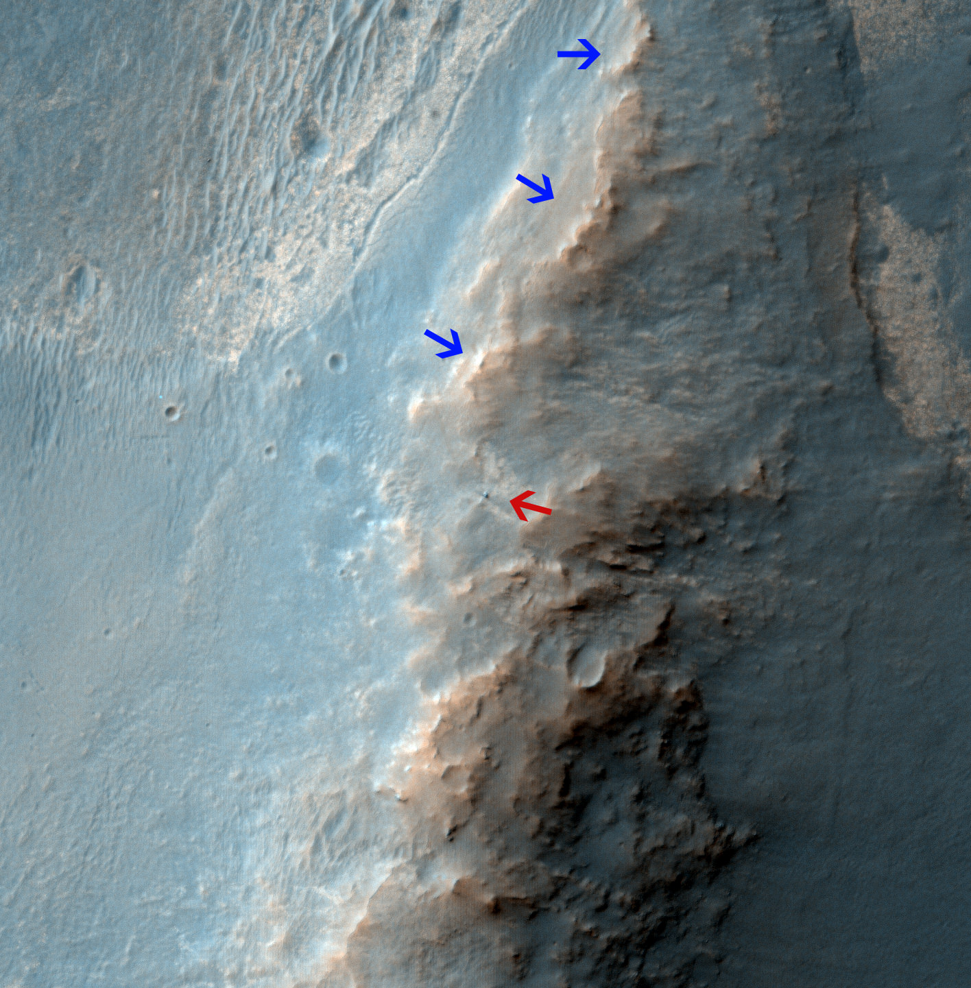
Opportunity Rover on ‘Murray Ridge’ Seen From Orbit on Valentine’s Day 2014
The telescopic High Resolution Imaging Science Experiment (HiRISE) camera on NASA’s Mars Reconnaissance Orbiter caught this view of NASA’s Mars Exploration Rover Opportunity on Feb. 14, 2014 by the summit of Solander Point. The red arrow points to Opportunity at the center of the image. Blue arrows point to tracks left by the rover since it entered the area seen here, in October 2013. The scene covers a patch of ground about one-quarter mile (about 400 meters) wide. North is toward the top. The location is the “Murray Ridge” section of the western rim of Endeavour Crater. Credit: NASA/JPL-Caltech/Univ. of Arizona
See below corresponding surface view snapped by Opportunity from this location[/caption]
NASA’s renowned Mars rover Opportunity has been spied anew in a fabulous new photo captured just days ago by NASA’s ‘Spy in the Sky’ orbiter circling overhead the Red Planet. See Opportunity from above and below – from today’s location. See orbital view above – just released today.
The highly detailed image was freshly taken on Feb. 14 (Valentine’s Day 2014) by the telescopic High Resolution Imaging Science Experiment (HiRISE) camera on NASA’s Mars Reconnaissance Orbiter (MRO) as the decade old Opportunity was investigating the tasty alien terrain on ‘Murray Ridge’ – nearby the celebrated ‘jelly doughnut’ rock by the summit of Solander Point. See surface views below.
The fabulous orbital image shows not only rover Opportunity at her location today, but also the breathtaking landscape around the robots current location as well as some of the wheel tracks created by the Martian mountaineer as she climbed from the plains below up to near the peak of Solander Point.
The scene is narrowly focused on a spot barely one-quarter mile (400 meters) wide.
Murray Ridge and Solander Point lie at the western rim of a vast crater named Endeavour that spans some 22 kilometers (14 miles) in diameter.
Here is the corresponding Martian surface view snapped by Opportunity on Feb. 16, 2014 (looking back and down to Endeavour crater), while she’s being imaged from Mars orbit on Feb. 14, 2014:
Endeavour is an impact scar created billions of years ago. See our 10 Year Opportunity traverse map below.
And believe it or not, that infamous ‘jelly doughnut’ rock was actually the impetus for this new imaging campaign by NASA’s MRO Martian ‘Spysat.’
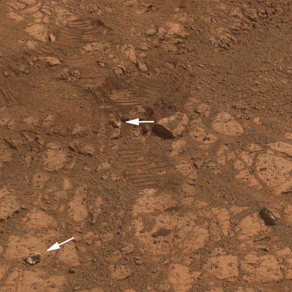
To help solve the mystery of the origin of the shiny 1.5 inches wide (4 centimeters) ‘jelly doughnut’ rock, dubbed ‘Pinnacle Island’, the science team decided to enlist the unparalleled capabilities of the HiRISE camera and imaging team in pursuit of answers.

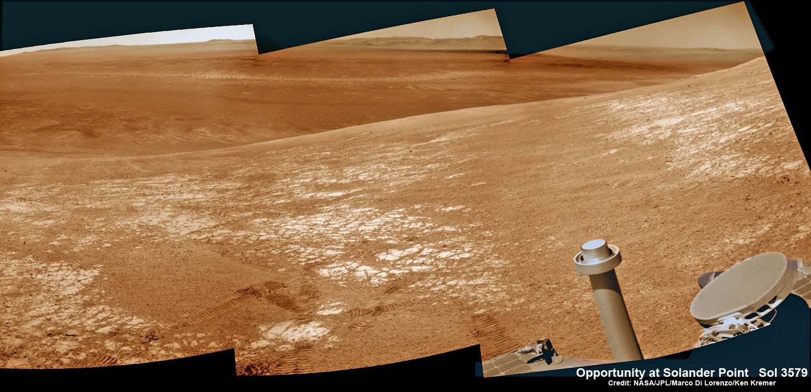
NASA’s Opportunity rover captured this panoramic mosaic on Dec. 10, 2013 (Sol 3512) near the summit of “Solander Point” on the western rim of Endeavour Crater where she starts Decade 2 on the Red Planet. She is currently investigating outcrops of potential clay minerals formed in liquid water on her 1st mountain climbing adventure. Assembled from Sol 3512 navcam raw images. Credit: NASA/JPL/Cornell/Marco Di Lorenzo/Ken Kremer-kenkremer.com
‘Pinnacle Island’ had suddenly appeared out of nowhere in a set of before/after pictures taken by Opportunity’s cameras on Jan, 8, 2014 (Sol 3540), whereas that exact same spot had been vacant of debris in photos taken barely 4 days earlier. And the rover hadn’t budged a single millimeter.
So the HiRISE research team was called in to plan a new high resolution observation of the ‘Murray Ridge’ area and gather clues about the rocky riddle.
The purpose was to “check the remote possibility that a fresh impact by an object from space might have excavated a crater near Opportunity and thrown this rock to its new location”- now known as Pinnacle Island, said NASA in a statement.
Well, no fresh crater impacting site was found in the new image.
“We see no obvious signs of a very recent crater in our image, but a careful comparison to prior images might reveal subtle changes,” wrote HiRISE principal investigator Alfred McEwen in a description today.
In the meantime, as I reported here a few days ago the mystery was solved at last by the rover team after Opportunity drove a short distance away from the ‘jelly doughnut’ rock and snapped some ‘look back’ photographs to document the ‘mysterious scene’ for further scrutiny.
It turns out that the six wheeled Opportunity unknowingly ‘created’ the mystery herself when she drove over a larger rock, crushing and breaking it apart with the force from the wheels and her hefty 400 pound (185 kg) mass.
“Once we moved Opportunity a short distance, after inspecting Pinnacle Island, we could see directly uphill an overturned rock that has the same unusual appearance,” said Opportunity Deputy Principal Investigator Ray Arvidson of Washington University in St. Louis, in a NASA statement.
“Murray Ridge” and the Solander Point mountaintop are of great scientific interest because the region is riven with outcrops of minerals, including clay minerals, that likely formed in flowing liquid neutral water conducive to life – potentially a scientific goldmine.
Today, Feb 19, marks Opportunity’s 3582nd Sol or Martian Day roving Mars. She is healthy with plenty of power.
So far she has snapped over 188,800 amazing images on the first overland expedition across the Red Planet.
Her total odometry stands at over 24.07 miles (38.73 kilometers) since touchdown on Jan. 24, 2004 at Meridiani Planum.
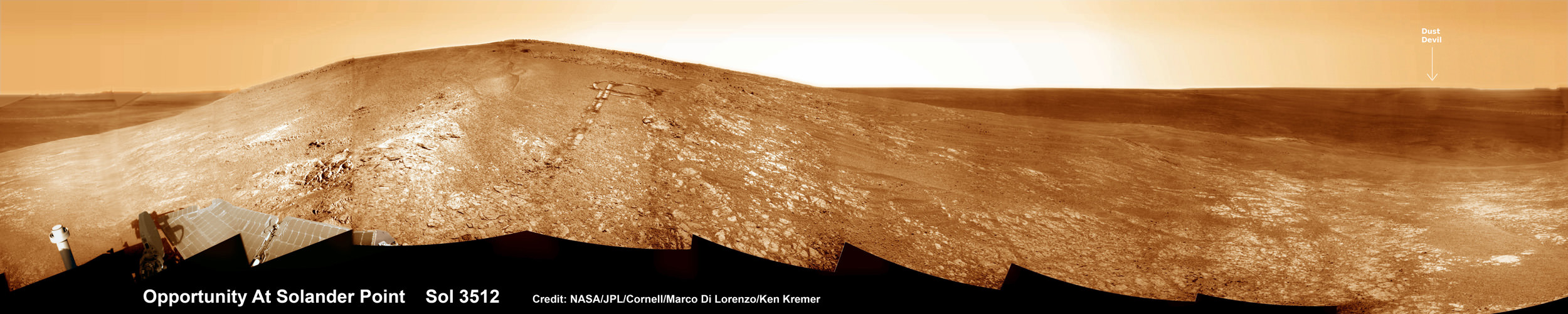
NASA’s Opportunity rover captured this panoramic mosaic on Dec. 10, 2013 (Sol 3512) near the summit of “Solander Point” on the western rim of vast Endeavour Crater where she starts Decade 2 on the Red Planet. She is currently investigating summit outcrops of potential clay minerals formed in liquid water on her 1st mountain climbing adventure. See wheel tracks at center and dust devil at right. Assembled from Sol 3512 navcam raw images. Credit: NASA/JPL/Cornell/Marco Di Lorenzo/Ken Kremer-kenkremer.com
Read more about sister Spirit – here and here.
Meanwhile on the opposite side of Mars, Opportunity’s younger sister rover Curiosity is trekking towards gigantic Mount Sharp and just crested over the Dingo Gap sand dune. She celebrated 500 Sols on Mars on New Years Day 2014.
And a pair of new orbiters are streaking to the Red Planet to fortify Earth’s invasion fleet- NASA’s MAVEN and India’s MOM.
Finally, China’s Yutu rover has awoken for her 3rd workday on the Moon.
Stay tuned here for Ken’s continuing Opportunity, Curiosity, Chang’e-3, LADEE, MAVEN, Mars rover, MOM and continuing planetary and human spaceflight news.
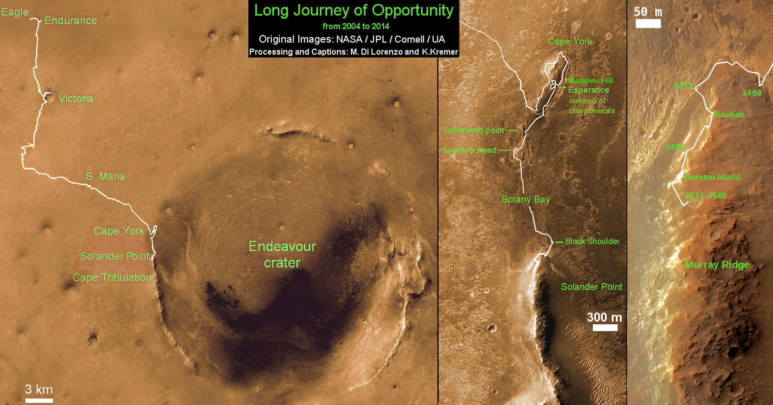
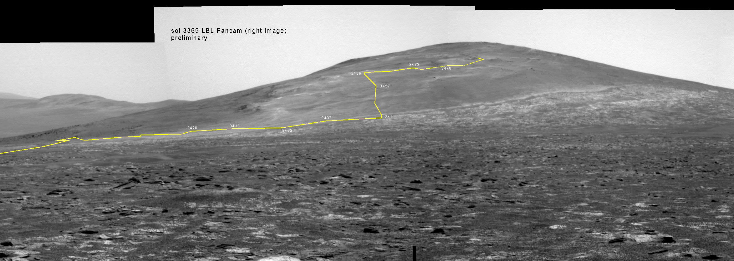
This map shows the entire path the rover has driven during a decade on Mars and over 3560 Sols, or Martian days, since landing inside Eagle Crater on Jan 24, 2004 to current location by Solander Point summit at the western rim of Endeavour Crater. Rover will spend 6th winter here atop Solander. Opportunity discovered clay minerals at Esperance – indicative of a habitable zone. Credit: NASA/JPL/Cornell/ASU/Marco Di Lorenzo/Ken Kremer – kenkremer.com