Curiosity Skips Drilling, Resumes Mount Sharp Trek after Pounding Slippery Rock at Martian Valley of Slippery Sands

NASA’s Curiosity rover hammers into ‘Bonanza King’ rock outcrop evaluating potential as 4th drill site for sampling at ‘Hidden Valley’ in this photo mosaic view captured on Aug. 20, 2014, Sol 724. Inset MAHLI camera image at right shows resulting rock indentation that caused it to budge and be unsafe for further drilling. Note the background of treacherous sand dune ripples and deep wheel tracks inside Hidden Valley that forced quick exit to alternate route forward. Navcam camera raw images stitched and colorized. Credit: NASA/JPL-Caltech/MSSS/Ken Kremer-kenkremer.com/Marco Di Lorenzo

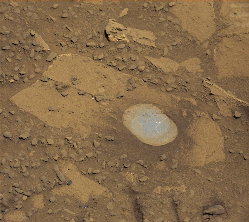
NASA’s Curiosity rover will skip drilling into a possible 4th rock target and instead resume the trek to Mount Sharp after finding it was unfortunately a slippery rock at the edge of a Martian valley of slippery sands and was therefore too risky to proceed with deep drilling and interior sampling for chemical analysis.

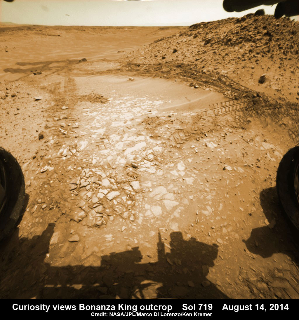
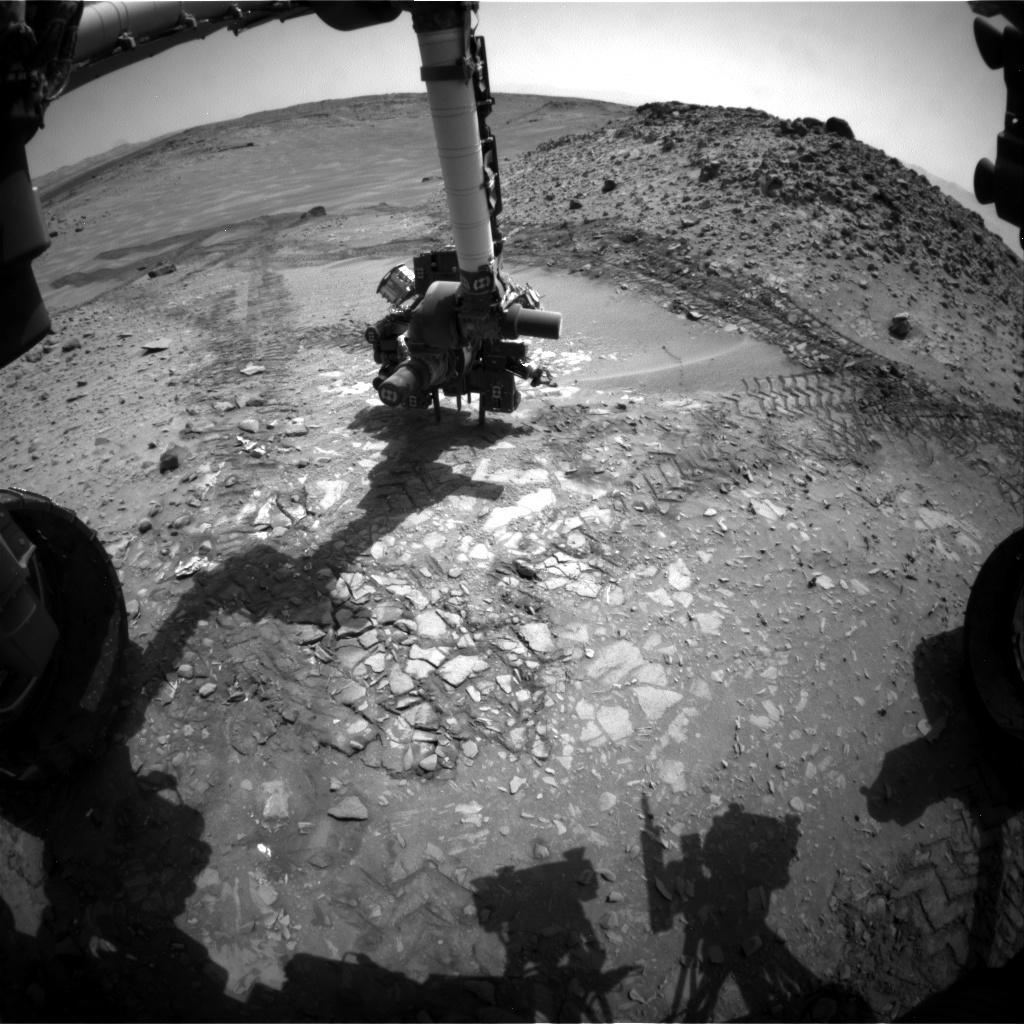
After pounding into the “Bonanza King” rock outcrop on Wednesday, Aug. 20, to evaluate its potential as Curiosity’s 4th drill target on Mars and seeing that it moved on impact, the team decided it was not even safe enough to continue with the preliminary ‘mini-drill’ operation that day.

So they cancelled the entire drill campaign at “Bonanza King” and decided to set the rover loose to drive onwards to her mountain climbing destination.

This image from the front Hazcam on NASA's Curiosity Mars rover shows the rover's drill in place during a test of whether the rock beneath it, "Bonanza King," would be an acceptable target for drilling to collect a sample. Subsequent analysis showed the rock budged during the Aug. 19, 2014, test. Credit: NASA/JPL-Caltech
This image from the front Hazcam on NASA’s Curiosity Mars rover shows the rover’s drill in place during a test of whether the rock beneath it, “Bonanza King,” would be an acceptable target for drilling to collect a sample. Subsequent analysis showed the rock budged during the Aug. 19, 2014, test. Credit: NASA/JPL-Caltech

“We have decided that the rocks under consideration for drilling, based on the tests we did, are not good candidates for drilling,” said Curiosity Project Manager Jim Erickson of NASA’s Jet Propulsion Laboratory, Pasadena, California, in a statement.

“Instead of drilling here, we will resume driving toward Mount Sharp.”

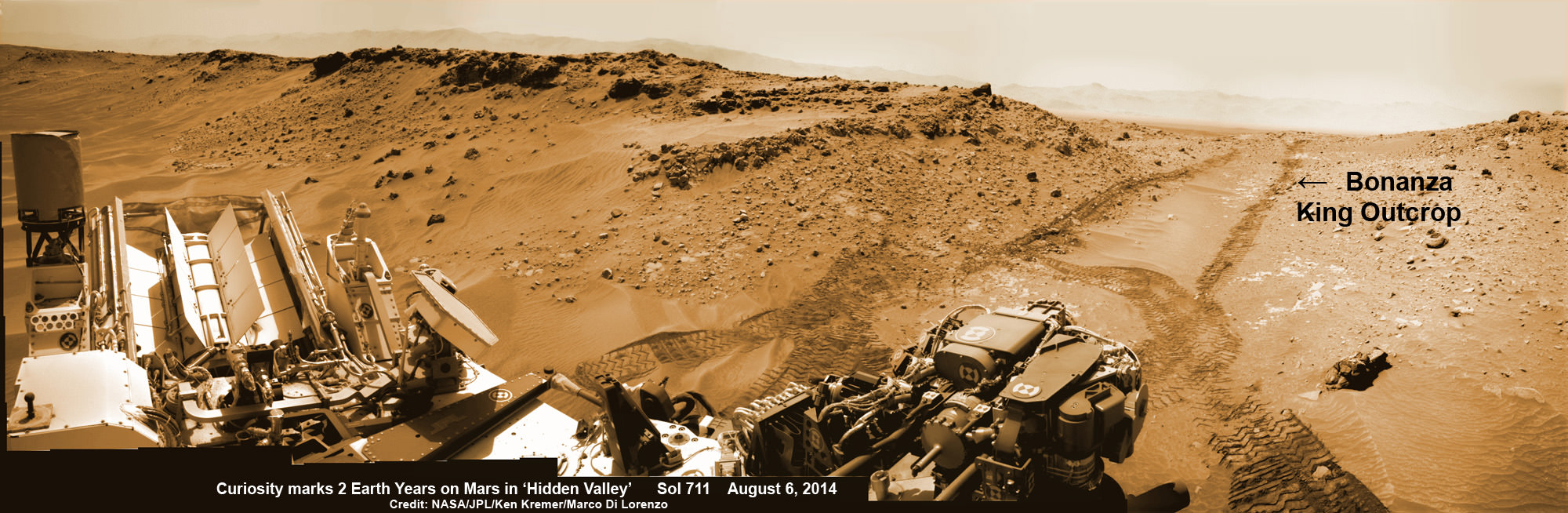
Bonanza King was an enticing target because the outcrop possessed thin, white, cross-cutting mineral veins which could indicate that liquid water flowed here in the distant past. Water is a prerequisite for life as we know it.

Loose, unstable rocks pose a prospective hazard to the 1 ton robots hardware and health if they become dislodged during impact by the percussive drill located at the end of the robotic arm.

It’s worth recalling that whirling rocks during the nailbiting Red Planet touchdown two years ago on Aug. 6, 2012, inside Gale Crater are suspected to have slightly damaged Curiosity’s REMS meteorological instrument station.

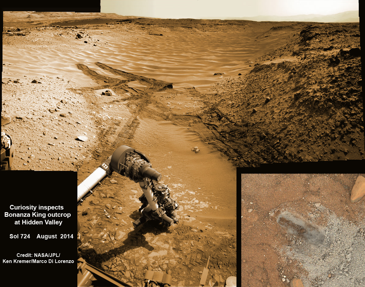
Each drill target must pass a series of tests. And the prior three at more extensive outcrops all met those criteria. By comparison, imagery showed Bonanza King was clearly part of a much smaller outcrop. See our Bonanza King photo mosaics herein.

NASA’s Curiosity rover looks back to ramp with potential 4th drill site target at ‘Bonanza King’ rock outcrop in ‘Hidden Valley’ in this photo mosaic view captured on Aug. 6, 2014, Sol 711.  Inset shows results of brushing on Aug. 17, Sol 722, that revealed gray patch beneath red dust.  Note the rover’s partial selfie, valley walls, deep wheel tracks in the sand dunes and distant rim of Gale crater beyond the ramp. Navcam camera raw images stitched and colorized.  Credit: NASA/JPL-Caltech/Ken Kremer-kenkremer.com/Marco Di Lorenzo
NASA’s Curiosity rover looks back to ramp with potential 4th drill site target at ‘Bonanza King’ rock outcrop in ‘Hidden Valley’ in this photo mosaic view captured on Aug. 6, 2014, Sol 711. Inset shows results of brushing on Aug. 17, Sol 722, that revealed gray patch beneath red dust. Note the rover’s partial selfie, valley walls, deep wheel tracks in the sand dunes and distant rim of Gale crater beyond the ramp. Navcam camera raw images stitched and colorized. Credit: NASA/JPL-Caltech/Ken Kremer-kenkremer.com/Marco Di Lorenzo

“One step in the procedure, called “start hole,” uses the hammering action of the percussive drill to create a small indentation in the rock. During this part of the test, the rock moved slightly, the rover sensed that instability in the target, and protective software properly halted the procedure,” according to a NASA statement.

This pale, flat Martian rock thus failed to pass the team’s safety criteria for drilling when it budged.

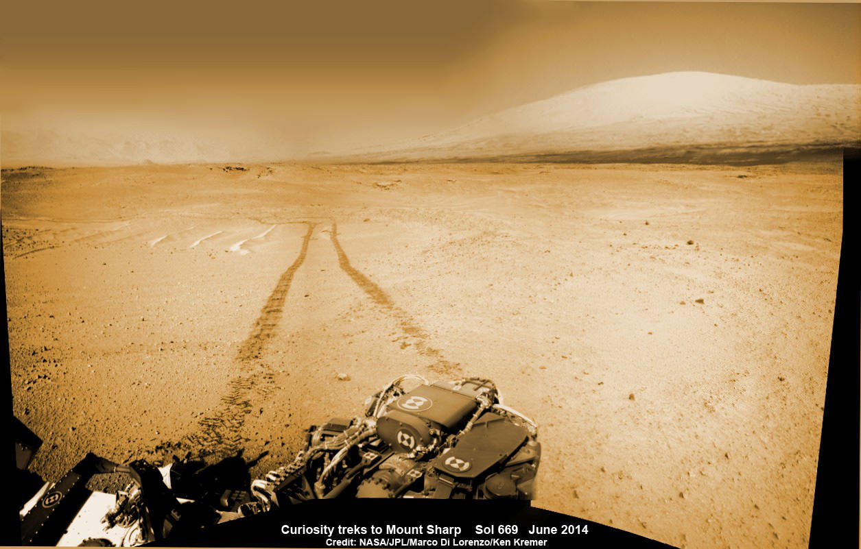
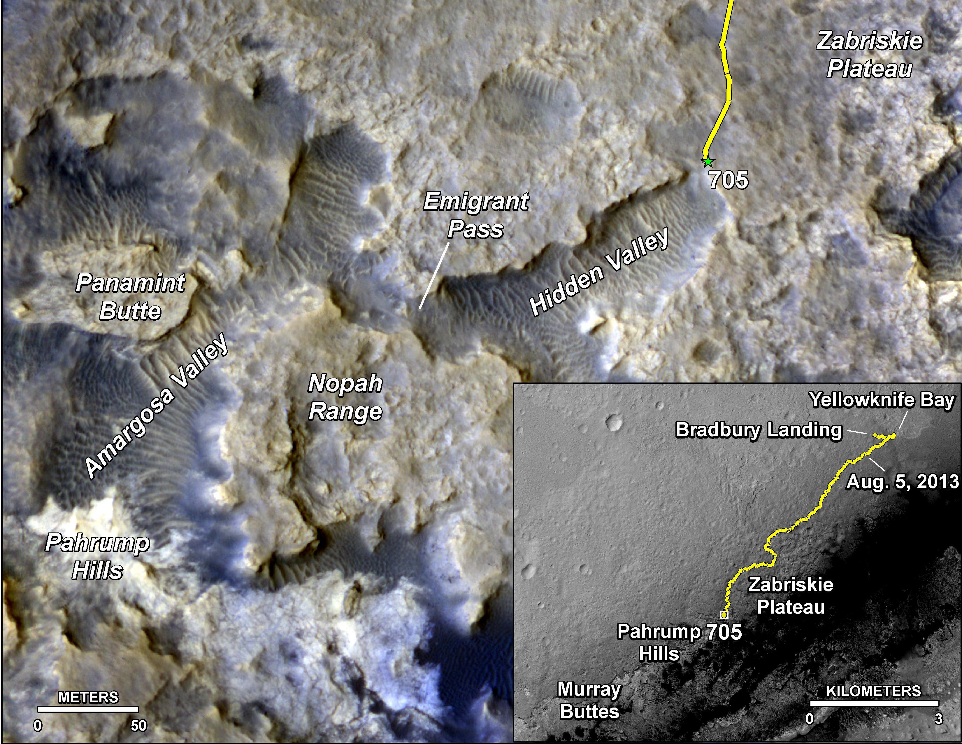
Bonanza King sits in an bright outcrop on the low ramp at the northeastern end of a spot leading in and out of an area called “Hidden Valley” which lies between Curiosity’s August 2012 landing site in Gale Crater and her ultimate destinations on Mount Sharp which dominates the center of the crater.

Just days ago, the rover team commanded a quick exit from “Hidden Valley” to backtrack out of the dune filled valley because of fears the six wheeled robot could get stuck in slippery sands extending the length of a football field.

“Hidden Valley” looked like it could turn into “Death Valley.”

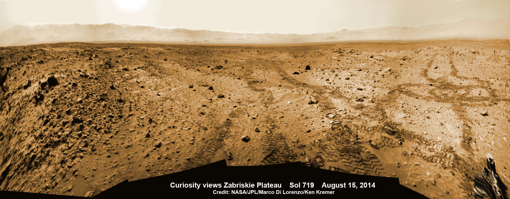
As Curiosity tested the outcrop, the rover team was simultaneously searching for an alternate safe path forward to the sedimentary layers of Mount Sharp because she arrived at Hidden Valley after recently driving over a field of sharp edged rocks in the “Zabriskie Plateau” that caused further rips and tears in the already damaged 20 inch diameter aluminum wheels.

It will take a route skirting the north side of the sandy-floored valley taking care to steer away from the pointiest rocks.

Curiosity rover looks back to the rocky plains of the Zabriskie plateau from sandy ramp into ‘Hidden Valley’ with 4th drill site target at ‘Bonanza King’ rock outcrop as shown in this photo mosaic view captured on Aug. 14, 2014, Sol 719.  Sharp edged rocks at Zabriskie tore new holes into rover wheels.   Navcam camera raw images stitched and colorized.  Credit: NASA/JPL-Caltech/Marco Di Lorenzo/Ken Kremer-kenkremer.com
Curiosity rover looks back to the rocky plains of the Zabriskie plateau from sandy ramp into ‘Hidden Valley’ with 4th drill site target at ‘Bonanza King’ rock outcrop as shown in this photo mosaic view captured on Aug. 14, 2014, Sol 719. Sharp edged rocks at Zabriskie tore new holes into rover wheels. Navcam camera raw images stitched and colorized. Credit: NASA/JPL-Caltech/Marco Di Lorenzo/Ken Kremer-kenkremer.com

“After further analysis of the sand, Hidden Valley does not appear to be navigable with the desired degree of confidence,” Erickson said. “We will use a route avoiding the worst of the sharp rocks as we drive slightly to the north of Hidden Valley.”

To date, Curiosity’s odometer totals over 5.5 miles (9.0 kilometers) since landing inside Gale Crater on Mars in August 2012. She has taken over 179,000 images.

Curiosity still has about another 2 miles (3 kilometers) to go to reach the entry way at a gap in the treacherous sand dunes at the foothills of Mount Sharp sometime later this year.

Hidden Valley gives a foretaste of the rippely slippery sand dune challenges lurking ahead!

Mount Sharp is a layered mountain that dominates most of Gale Crater and towers 3.4 miles (5.5 kilometers) into the Martian sky and is taller than Mount Rainier.

“Getting to Mount Sharp is the next big step for Curiosity and we expect that in the Fall of this year,” Dr. Jim Green, NASA’s Director of Planetary Sciences at NASA Headquarters, Washington, DC, told me in an interview marking the 2nd anniversary since touchdown on Aug. 6.

“Drilling on the crater floor will provide needed geologic context before Curiosity climbs the mountain.”

The team may go back to its original plan to drill at the potential science destination known as “Pahrump Hills” which was changed due to the route change forced by the slippery sands in Hidden Valley.

The main map here shows the assortment of landforms near the location of NASA's Curiosity Mars rover as the rover's second anniversary of landing on Mars nears. The gold traverse line entering from upper right ends at Curiosity's position as of Sol 705 on Mars (July 31, 2014). The inset map shows the mission's entire traverse from the landing on Aug. 5, 2012, PDT (Aug. 6, EDT) to Sol 705, and the remaining distance to long-term science destinations near Murray Buttes, at the base of Mount Sharp. The label "Aug. 5, 2013" indicates where Curiosity was one year after landing.    Credit: NASA/JPL-Caltech/Univ. of Arizona
The main map here shows the assortment of landforms near the location of NASA’s Curiosity Mars rover as the rover’s second anniversary of landing on Mars nears. The gold traverse line entering from upper right ends at Curiosity’s position as of Sol 705 on Mars (July 31, 2014). The inset map shows the mission’s entire traverse from the landing on Aug. 5, 2012, PDT (Aug. 6, EDT) to Sol 705, and the remaining distance to long-term science destinations near Murray Buttes, at the base of Mount Sharp. The label “Aug. 5, 2013” indicates where Curiosity was one year after landing. Credit: NASA/JPL-Caltech/Univ. of Arizona

Read an Italian language version of this story by my imaging partner Marco Di Lorenzo – here

Stay tuned here for Ken’s continuing Rosetta, Curiosity, Opportunity, Orion, SpaceX, Boeing, Orbital Sciences, Dream Chaser, commercial space, MAVEN, MOM, Mars and more planetary and human spaceflight news.

Ken Kremer

Curiosity rover panorama of Mount Sharp captured on June 6, 2014 (Sol 651) during traverse inside Gale Crater.  Note rover wheel tracks at left.  She will eventually ascend the mountain at the ‘Murray Buttes’ at right later this year. Assembled from Mastcam color camera raw images and stitched by Marco Di Lorenzo and Ken Kremer.   Credit:   NASA/JPL/MSSS/Marco Di Lorenzo/Ken Kremer-kenkremer.com
Curiosity rover panorama of Mount Sharp captured on June 6, 2014 (Sol 651) during traverse inside Gale Crater. Note rover wheel tracks at left. She will eventually ascend the mountain at the ‘Murray Buttes’ at right later this year. Assembled from Mastcam color camera raw images and stitched by Marco Di Lorenzo and Ken Kremer. Credit: NASA/JPL/MSSS/Marco Di Lorenzo/Ken Kremer-kenkremer.com
Up close view of hole in one of rover Curiosity’s six wheels caused by recent driving over rough Martian rocks. Mosaic assembled from Mastcam raw images taken on Dec. 22, 2013 (Sol 490).  Credit: NASA/JPL/MSSS/Ken Kremer - kenkremer.com/Marco Di Lorenzo
Up close view of hole in one of rover Curiosity’s six wheels caused by recent driving over rough Martian rocks. Mosaic assembled from Mastcam raw images taken on Dec. 22, 2013 (Sol 490). Credit: NASA/JPL/MSSS/Ken Kremer – kenkremer.com/Marco Di Lorenzo

Rosetta Moving Closer to Comet 67P Hunting for Philae Landing Site

Holger Sierks, OSIRIS principal investigator, discusses spectacular hi res comet images returned so far by Rosetta during the Aug. 6 ESA webcast from mission control at ESOC, Darmstadt, Germany. Credit: Roland Keller

Animation Caption: Possible landing sites on Comet 67P/Churyumov-Gerasimenko. The model shows the illumination of the comets surface and regions under landing site consideration for the Philae lander on board ESA’s Rosetta spececraft . Credit: CNES

“The race is on” to find a safe and scientifically interesting landing site for the Philae lander piggybacked on ESA’s Rosetta spacecraft as it swoops in ever closer to the heavily cratered Comet 67P/Churyumov-Gerasimenko since arriving two weeks ago after a decade long chase of 6.4 billion kilometers (4 Billion miles).

Rosetta made history by becoming the first ever probe from Earth to orbit a comet upon arrival on Aug. 6, 2014.

The probe discovered an utterly alien and bizarre icy wanderer that science team member Mark McCaughrean, of ESA’s Science Directorate, delightedly calls a ‘Scientific Disneyland.’

“It’s just astonishing,” he said during a live ESA webcast of the Aug. 6 arrival event.

Now, another audacious and history making event is on tap – Landing on the comet!

To enable a safe landing, Rosetta is moving in closer to the comet to gather higher resolution imaging and spectroscopic data. When Rosetta arrived on Aug. 6, it was initially orbiting at a distance of about 100 km (62 miles). As of today, carefully timed thruster firings have brought it to within about 80 km distance. And it will get far closer.

Right now a top priority task for the science and engineering team leading Rosetta is “Finding a landing strip” for the Philae comet lander.

Philae’s landing on comet 67P is currently scheduled for Nov. 11, 2014. The 100 kg lander is equipped with 10 science instruments

“The challenge ahead is to map the surface and find a landing strip,” said Andrea Accomazzo, ESA Rosetta Spacecraft Operations Manager, at the Aug. 6 ESA webcast.

The team responsibility for choosing the candidate sites comprises “the Landing Site Selection Group (LSSG), which comprises engineers and scientists from Philae’s Science, Operations and Navigation Centre (SONC) at CNES, the Lander Control Centre (LCC) at DLR, scientists representing the Philae Lander instruments, and supported by the ESA Rosetta team, which includes representatives from science, operations and flight dynamics,” according to an ESA statement.

This week the team is intensively combing through a preliminary list of 10 potential landing sites.

Over the weekend they will whittle the list down to five candidate landing sites for continued detailed analysis.

ESA will announce the Top 5 landing site candidates on Monday, Aug. 25.

This image of comet 67P/Churyumov-Gerasimenko shows the diversity of surface structures on the comet's nucleus. It was taken by the Rosetta spacecraft's OSIRIS narrow-angle camera on August 7, 2014. At the time, the spacecraft was 65 miles (104 kilometers) away from the 2.5 mile (4 kilometer) wide nucleus.  Credit:  ESA/Rosetta/MPS for OSIRIS Team MPS/UPD/LAM/IAA/SSO/INTA/UPM/DASP/IDA/Enhanced processing Marco Di Lorenzo/Ken Kremer
Where will Philae land?
This image of comet 67P/Churyumov-Gerasimenko shows the diversity of surface structures on the comet’s nucleus. It was taken by the Rosetta spacecraft’s OSIRIS narrow-angle camera on August 7, 2014. At the time, the spacecraft was 65 miles (104 kilometers) away from the 2.5 mile (4 kilometer) wide nucleus. Credit: ESA/Rosetta/MPS for OSIRIS Team MPS/UPD/LAM/IAA/SSO/INTA/UPM/DASP/IDA/Enhanced processing Marco Di Lorenzo/Ken Kremer

The decision rests on the results of Rosetta’s ongoing global mapping campaign, including high resolution imaging from the OSIRIS and NAVCAM cameras and further observations from the other science instruments, especially MIRO, VIRTIS, ALICE, GIADA and ROSINA.

The surface criteria for a suitable landing site include day time landing illumination, a balance between day and night to allow the solar panels to recharge the batteries, avoiding steep slopes, large boulders and deep crevasses so it doesn’t topple over.

Of course the team also must consider the comet’s rotation period (12.4 hours) and axis of rotation (see animation at top). Sites near the equator offering roughly equal periods of day and night may be preferred.

The selection of the primary landing site is slated for mid-October after consultation between ESA and the lander team on a “Go/No Go” decision.

The three-legged lander will fire two harpoons and use ice screws to anchor itself to the 4 kilometer (2.5 mile) wide comet’s surface. Philae will collect stereo and panoramic images and also drill 23 centimeters into and sample its incredibly varied surface.

Artist impression of Philae on the surface of comet 67P/Churyumov-Gerasimenko.  Credit: ESA/ATG medialab
Artist impression of Philae on the surface of comet 67P/Churyumov-Gerasimenko. Credit: ESA/ATG medialab

Read an Italian language version of this story by my imaging partner Marco Di Lorenzo – here

Stay tuned here for Ken’s continuing Earth and Planetary science and human spaceflight news.

Ken Kremer

Curiosity Brushes ‘Bonanza King’ Target Anticipating Fourth Red Planet Rock Drilling

NASA’s Curiosity rover looks back to ramp with potential 4th drill site target at ‘Bonanza King’ rock outcrop in ‘Hidden Valley’ in this photo mosaic view captured on Aug. 6, 2014, Sol 711. Inset shows results of brushing on Aug. 17, Sol 722, that revealed gray patch beneath red dust. Note the rover’s partial selfie, valley walls, deep wheel tracks in the sand dunes and distant rim of Gale crater beyond the ramp. Navcam camera raw images stitched and colorized. Credit: NASA/JPL-Caltech/Ken Kremer-kenkremer.com/Marco Di Lorenzo

Curiosity brushes ‘Bonanza King’ drill target on Mars
NASA’s Curiosity rover looks back to ramp with 4th drill site target at ‘Bonanza King’ rock outcrop in ‘Hidden Valley’ in this photo mosaic view captured on Aug. 6, 2014, Sol 711. Inset shows results of brushing on Aug. 17, Sol 722, that revealed gray patch beneath red dust. Note the rover’s partial selfie, valley walls, deep wheel tracks in the sand dunes and distant rim of Gale crater beyond the ramp. Navcam camera raw images stitched and colorized.
Credit: NASA/JPL-Caltech/Ken Kremer-kenkremer.com/Marco Di Lorenzo[/caption]

Eagerly eyeing her next drill site on Mars, NASA’s Curiosity rover laid the groundwork by brushing the chosen rock target called ‘Bonanza King’ on Wednesday, Aug. 17, Sol 722, with the Dust Removal Tool (DRT) and collecting high resolution imagery with the Mast Camera (Mastcam) to confirm the success of the operation.

By brushing aside the reddish, more-oxidized dust scientists and engineers leading the mission observed a gray patch of less-oxidized rock material beneath that they anticipated seeing while evaluating the utility of ‘Bonanza King’ as the rover’s fourth candidate for Red Planet rock drilling and sampling.

To date, the 1-ton robot has drilled into three target rocks to collect sample powder for analysis by the rover’s onboard pair of the chemistry labs, SAM and CheMin, to analyze for the chemical ingredients that could support Martian microbes, if they ever existed.

Curiosity rover used the Dust Removal Tool on its robotic arm to brush aside reddish, more-oxidized dust, revealing a gray patch of less-oxidized rock material at a target called "Bonanza King," visible in this image from the rover's Mast Camera (Mastcam). Credit: NASA/JPL-Caltech/MSSS
Curiosity rover used the Dust Removal Tool on its robotic arm to brush aside reddish, more-oxidized dust, revealing a gray patch of less-oxidized rock material at a target called “Bonanza King,” visible in this image from the rover’s Mast Camera (Mastcam). Credit: NASA/JPL-Caltech/MSSS

So far everything is proceeding quite well.

The brushing activity also revealed thin, white, cross-cutting veins which is a further indication that liquid water flowed here in the distant past. Water is a prerequisite for life as we know it.

“They might be sulfate salts or another type of mineral that precipitated out of solution and filled fractures in the rock. These thin veins might be related to wider light-toned veins and features in the surrounding rock,” NASA said in a statement.

Based on these results and more from laser zapping with Curiosity’s Chemistry and Camera (ChemCam) instrument on Sol 719 (Aug. 14, 2014) the team decided to proceed ahead.

The imminent next step is to bore a shallow test hole into the brushed area which measures about about 2.5 inches (6 centimeters) across.

If all goes well with the “mini-drill” operation, the team will proceed quickly with full depth drilling to core a sample from the interior of the dinner plate sized rock slab for delivery to Curiosity’s two chemistry labs.

Bonanza King sits in a bright outcrop on the low ramp at the northeastern end of a spot leading in and out of an area called “Hidden Valley” which lies between Curiosity’s August 2012 landing site in Gale Crater and her ultimate destinations on Mount Sharp which dominates the center of the crater.

Just days ago, the rover team commanded a quick exit from “Hidden Valley” to backtrack out of the dune filled valley because of fears the six wheeled robot could get stuck in slippery sands extending the length of a football field.

As Curiosity drills, the rover team is also searching for an alternate safe path forward to the sedimentary layers of Mount Sharp.

To date, Curiosity’s odometer totals over 5.5 miles (9.0 kilometers) since landing inside Gale Crater on Mars in August 2012. She has taken over 178,000 images.

The main map here shows the assortment of landforms near the location of NASA's Curiosity Mars rover as the rover's second anniversary of landing on Mars nears. The gold traverse line entering from upper right ends at Curiosity's position as of Sol 705 on Mars (July 31, 2014). The inset map shows the mission's entire traverse from the landing on Aug. 5, 2012, PDT (Aug. 6, EDT) to Sol 705, and the remaining distance to long-term science destinations near Murray Buttes, at the base of Mount Sharp. The label "Aug. 5, 2013" indicates where Curiosity was one year after landing.    Credit: NASA/JPL-Caltech/Univ. of Arizona
The main map here shows the assortment of landforms near the location of NASA’s Curiosity Mars rover as the rover’s second anniversary of landing on Mars nears. The gold traverse line entering from upper right ends at Curiosity’s position as of Sol 705 on Mars (July 31, 2014). The inset map shows the mission’s entire traverse from the landing on Aug. 5, 2012, PDT (Aug. 6, EDT) to Sol 705, and the remaining distance to long-term science destinations near Murray Buttes, at the base of Mount Sharp. The label “Aug. 5, 2013” indicates where Curiosity was one year after landing. Credit: NASA/JPL-Caltech/Univ. of Arizona

Curiosity still has about another 2 miles (3 kilometers) to go to reach the entry way at a gap in the treacherous sand dunes at the foothills of Mount Sharp sometime later this year.

Mount Sharp is a layered mountain that dominates most of Gale Crater and towers 3.4 miles (5.5 kilometers) into the Martian sky and is taller than Mount Rainier.

“Getting to Mount Sharp is the next big step for Curiosity and we expect that in the Fall of this year,” Dr. Jim Green, NASA’s Director of Planetary Sciences at NASA Headquarters, Washington, DC, told me in an interview making the 2nd anniversary on Aug. 6.

“Drilling on the crater floor will provide needed geologic context before Curiosity climbs the mountain.”

1 Martian Year on Mars!  Curiosity treks to Mount Sharp in this photo mosaic view captured on Sol 669, June 24, 2014.    Navcam camera raw images stitched and colorized.   Credit: NASA/JPL-Caltech/Marco Di Lorenzo/Ken Kremer – kenkremer.com
1 Martian Year on Mars! Curiosity treks to Mount Sharp in this photo mosaic view captured on Sol 669, June 24, 2014. Navcam camera raw images stitched and colorized. Credit: NASA/JPL-Caltech/Marco Di Lorenzo/Ken Kremer – kenkremer.com

Read an Italian language version of this story by my imaging partner Marco Di Lorenzo – here

Stay tuned here for Ken’s continuing Rosetta, Curiosity, Opportunity, Orion, SpaceX, Boeing, Orbital Sciences, Dream Chaser, commercial space, MAVEN, MOM, Mars and more planetary and human spaceflight news.

Ken Kremer

One That Fell to Earth: Researchers Reveal 2012 Novato Meteorite Took a Beating

End of flight fragmentation of the Nov. 18, 2012, fireball over the San Francisco Bay Area (shown in a horizontally mirrored image to depict the time series from left to right). The photographs were taken from a distance of about 40 miles (65 km). Image Credit: Robert P. Moreno Jr., Jim Albers and Peter Jenniskens

What’s the chance of that thump you just heard in your house was a meteorite hitting your roof? That was the case for one family in Novato, California during a fireball event that took place in the north bay area near San Francisco on October 17, 2012.

Researchers have now released new results from analysis of the meteor that fell to Earth, revealing that the “Novato meteorite” was part of numerous collisions over a span of 4 billion years.

There is nothing ordinary about a meteorite whether it just spent 4.4 billion years all alone or spent such time in a game of cosmic pinball, interacting with other small or large bodies of our Solar System. On any given night one can watch at least a couple of meteors overhead burning up, lighting up the sky but never reaching the Earth below. However, in less than two years, Dr. Peter Jenniskens, SETI Institute’s renowned meteor expert was effectively host to two meteorites within a couple hours drive from his office in Mountain View, California.

The first was the Sutter Mill meteorite, a fantastic carbonaceous chondrite full of organic compounds. The second was the Novato meteorite, identified as a L6 chondrite fragmental breccia. which is the focus of new analysis, to be released in a paper in the August issue of Meteoritics and Planetary Science. Early on, it was clear that this meteorite had been a part of a larger asteroidal parent body that had undergone impact shocks.

Analysis of the meteorite was spearheaded by Jenniskens who initially determined the trajectory and orbit of the meteoroid from the Cameras for Allsky Meteor Surveillance (CAMS) which he helped establish in the greater San Francisco bay area. Jenniskens immediately released information about the fireball to local news agencies to ask for the public’s help with the hopes of finding pieces of the meteorite. One resident recalled hearing something hit her roof, and with the help of neighbors, they investigated and soon found the first fragment in their backyard.

Finding fragments was the first step, and over a two year period, the analysis of the Novato meteorite was spread across several laboratories around the world with specific specialties.

Novato N04, found by Bob Verish. The fourth of 6 fragments of the Novato fireball recovered. (Image Credit, B. Verish)
Novato N04, found by Bob Verish. The fourth of six fragments of the Novato fireball recovered. Fusion crust from entry into the Earth’s atmosphere is clearly evident. A 1 centimeter cube is shown for size comparison. (Image Credit, B. Verish, cams.seti.org)

Dr. Jenniskens, along with 50 co-authors, have concluded that the Novato meteorite had been involved in more impacts than previously thought. Dr. Qingzhu Yin, professor in the Department of Earth and Planetary Sciences at the University of California, Davis stated, “We determined that the meteorite likely got its black appearance from massive impact shocks causing a collisional resetting event 4.472 billion years ago, roughly 64-126 million years after the formation of the solar system.”

The predominant theory of the Moon’s formation involves an impact of the Earth by a Mars-sized body. The event resulted in the formation of the Moon but also the dispersal of many fragments throughout the inner Solar System. Dr. Qingzhu Yin continued, “We now suspect that the moon-forming impact may have scattered debris all over the inner solar system and hit the parent body of the Novato meteorite.”

Additionally, the researcher discovered that the parent body of the Novato meteorite experienced a massive impact event approximately 470 million years ago. This event dispersed many asteroidal fragments throughout the Asteroid Belt including a fragment from which resulted the Novato meteorite.

The Novato meteorite strewn field determined by Dr. Jenniskens team's analysis of CAMS allsky images. (Illustration Credit, P. Jenniskens, NASA/SETI)
The Novato meteorite strewn field determined by Dr. Jenniskens team’s analysis of CAMS allsky images. (Illustration Credit, P. Jenniskens, NASA, SETI – cams.seti.org)

The trajectory analysis completed earlier by Dr. Jenniskens pointed the Novato meteorite back to the Gefion asteroid family. Dr. Kees Welten, cosmochemist at UC Berkeley, was able to further pinpoint the time, drawing the conclusion, “Novato broke from one of the Gefion family asteroids nine million years ago.” His colleague at Berkeley, cosmochemist Dr. Kunihiko Nishiizumialso added, “but may have been buried in a larger object until about one million years ago.”

There was more that could be revealed about history of  the Novato meteorite. Dr. Derek Sears a meteoriticist working for the Bay Area Environmental Research Institute in Sonoma, California and stationed at NASA Ames Reserach Center applied his expertise in thermoluminescence. Dr. Sears was involved in the analysis of Lunar regolith returned by the Apollo astronauts using this analysis method.

“We can tell the rock was heated, but the cause of the heating is unclear,” said Dr. Sears, “It seems that Novato was hit again.” As stated in the NASA press release, “Scientists at Ames measured the meteorites’ thermoluminescence – the light re-emitted when heating of the material and releasing the stored energy of past electromagnetic and ionizing radiation exposure – to determine that Novato may have had another collision less than 100,000 years ago.”

From this apparent final collision one hundred thousand years ago, the Novato meteoroid completed over 10,000 orbits of the Sun and with its final Solar orbit, intercepted the Earth, entering our atmosphere and mostly burning up over California. The meteoroid is estimated to have measured 14 inches across (35 cm) and have weighed 176 pounds (80 kg). What reached the ground likely amounted to less than 5 lbs. (~ 2 kg). Only six fragments were recovered and many more remain buried or hidden in Sonoma and Napa counties.

Besides the analysis that revealed the series of likely impact events in the meteoroids history, a team led by Dr. Dan Glavin from NASA Goddard Space Flight Center undertook analysis in search of amino acids, the building blocks of life. They detected non-protein amino acids in the meteorite that are very rare on Earth. Dr. Jenniskens emphasized that the quick recovery of the fragments by scores of individuals that searched provided pristine samples for analysis.

The impact dent on the rooftop of the Webber home in Novato. Luis Rivera points to the dent. (Image Credit, P.Jenniskens, L.Rivera, cams.seti.org)

Robert P. Moreno, Jr. in Santa Rosa, CA photographed the fireball in greatest detail with a high resolution camera. Several other photos were brought forward from other vantage points. Dr. Jenniskens stated, “These photographs show that this meteorite – now one of the best studied meteorites of its kind – broke in spurts, each time creating a flash of light as it entered Earth’s atmosphere.”

An animated gif of the series of photographs taken by Robert Moreno Jr. (Credit, R. Moreno Jr., NASA, SETI)
An animated gif of the series of photographs taken by Robert Moreno Jr. Click on the image to animate in full resolution. (Credit, R. Moreno Jr., NASA, SETI)

Numerous individuals and groups undertook the search for the Novato meteorite. Dr. Jenniskens trajectory analysis included a likely impact zone or strewn field. People from all walks of life roamed the streets, open fields and hillsides of the north bay in search of fragments. Despite organized searches by Dr. Jenniskens, it was the footwork from other individuals that led to finding six fragments and was the first step which led to these studies that add to the understanding  of the early Solar System’s development.

For Dr. Jenniskens, Novato was part of a trifecta – the April 22, 2012, Sutter Mill meteorite in the nearby foothills of the Sierras, the Novato meteorite and the massive Chelyabinsk airburst event in Russia on February 15, 2013. Throughout this period, Dr. Jenniskens all-sky camera network continued to expand and record “falling stars” – meteors. The number of meteors recorded with calculated trajectories is now over 175,000. The SETI Institute researcher has been supported by NASA and personnel at the institute and ordinary citizens including amateur astronomers that have refined the methods for meteor orbital determination and estimating their size and mass. Several websites have compiled images and results for the Novato meteorite with Dr. Jenniskens’ – CAMS.SETI.ORG being most prominent.

Cygnus Cargo Carrier Concludes with Fiery Reentry Aug. 17 – Amazing Astronaut Photos

Cygnus reentry [17 Aug 2014]. In 84 days Reid, Max and I will ride home inside such an amazing fireball! Credit: NASA/ESA/Alexander Gerst

Cygnus reentry [17 Aug 2014]. In 84 days Reid, Max and I will ride home inside such an amazing fireball! Credit: NASA/ESA/Alexander Gerst
Story updated[/caption]

Farewell Cygnus!

The flight of the Orbital Sciences’ Cygnus commercial cargo carrier concluded this morning, Sunday Aug. 17, in a spectacular fireball as planned upon reentry into Earth’s atmosphere at approximately 9:15 a.m. (EDT). And the fireworks were captured for posterity in a series of amazing photos taken by the Expedition 40 crew aboard the International Space Station (ISS). See astronaut photos above and below.

ESA astronaut Alexander Gerst and Russian Cosmonaut Maxim Suraev documented the breakup and disintegration of Cygnus over the Pacific Ocean east of New Zealand today following precise thruster firings commanded earlier by Orbital Sciences mission control in Dulles, VA, that slowed the craft and sent it on a preplanned destructive reentry trajectory.

Cygnus reentry on 17 Aug 2014.  Credit: NASA/ESA/Alexander Gerst
Cygnus reentry on 17 Aug 2014. Credit: NASA/ESA/Alexander Gerst

Gerst was truly moved by the spectacle of what he saw as a portent for his voyage home inside a Soyuz capsule barely three months from now, with crew mates Maxim Suraev and NASA astronaut Reid Wiseman.

“In 84 days Reid, Max and I will ride home inside such an amazing fireball! In 84 Tagen werden Reid, Max & ich in solch einem Feuerball nach Hause fliegen!” – Gerst wrote from the station today in his social media accounts with the fireball photos.

Cygnus was loaded with no longer needed trash and fell harmlessly over an uninhabited area of the South Pacific Ocean.

Today’s spectacular reentry fireworks concluded the hugely successful flight of the Cygnus resupply ship named in honor of astronaut Janice Voss on the Orb-2 mission.

ISS Crewmate Max Suraev just caught this amazing photo of Cygnus Orb2 disintegrating on reentry.   Credit: Roscosmos/ Max Suraev via ISS crew mate Reid Wiseman
ISS Crew mate Max Suraev just caught this amazing photo of Cygnus Orb2 disintegrating on reentry. Credit: Roscosmos/ Max Suraev via ISS crew mate Reid Wiseman

The astronaut photos may be helpful to engineers planning the mechanics of the eventual deorbiting of the ISS at some point in the hopefully distant future.

Cygnus finished it’s month-long resupply mission two days ago when it was unberthed from the International Space Station (ISS) on Friday, Aug. 15, and station astronaut Alex Gerst released the vessel from the snares of the Canadarm2 robotic arm at 6:40 a.m. EDT.

“From start to finish, we are very pleased with the results of this mission. Our team is proud to be providing essential supplies to the ISS crew so they can carry out their vital work in space,” said Mr. Frank Culbertson, Executive Vice President and General Manager of Orbital’s Advanced Programs Group, in a statement.

Goodbye, Cygnus!  Credit: NASA/ESA/Alexander Gerst
Goodbye, Cygnus! Credit: NASA/ESA/Alexander Gerst

Cygnus roared to orbit during a spectacular blastoff on July 13 atop an Orbital Sciences Corp. Antares rocket on the Orb-2 mission at 12:52 p.m. (EDT) from the beachside Pad 0A at the Mid-Atlantic Regional Spaceport on NASA’s Wallops Flight Facility on the Eastern Shore of Virginia.

It arrived at the station after a three day chase and was captured with the 58-foot (17-meter) long Canadian robotic arm on July 16, 2014 by Station Commander Steve Swanson working at a robotics workstation in the cupola.

Orbital Sciences Corporation Antares rocket and Cygnus spacecraft blasts off on July 13  2014 from Launch Pad 0A at NASA Wallops Flight Facility , VA, on the Orb-2 mission and loaded with over 3000 pounds of science experiments and supplies for the crew aboard the International Space Station. Credit: Ken Kremer - kenkremer.com
Orbital Sciences Corporation Antares rocket and Cygnus spacecraft blasts off on July 13 2014 from Launch Pad 0A at NASA Wallops Flight Facility , VA, on the Orb-2 mission and loaded with over 3000 pounds of science experiments and supplies for the crew aboard the International Space Station. Credit: Ken Kremer – kenkremer.com

Cygnus arrival at the ISS took place on the 45th anniversary of the launch of Apollo 11 on July 16, 1969 on America’s first manned moon landing mission by Neil Armstrong, Buzz Aldrin and Michael Collins.

The US/Italian built pressurized Cygnus cargo freighter delivered 1,657 kg (3653 lbs) of cargo to the ISS Expedition 40 crew including over 700 pounds (300 kg) of science experiments and instruments, crew supplies, food, water, computer equipment, spacewalk tools and student research experiments.

This mission dubbed Orbital-2, or Orb-2, marks the second of at least eight operational cargo resupply missions to the ISS under Orbital’s Commercial Resupply Services (CRS) contract with NASA.

Cygnus Orb-2 spacecraft ‘Janice Voss’ departed ISS at 6:40 a.m.  EDT, Friday, Aug. 15, 2014.  Credit: NASA TV
Cygnus Orb-2 spacecraft ‘Janice Voss’ departed ISS at 6:40 a.m. EDT, Friday, Aug. 15, 2014. Credit: NASA TV

The next resupply launch of the private Cygnus Orb-3 craft atop the Orbital Sciences’ Antares rocket is currently scheduled for October 2014 from NASA’s Wallops Flight Facility, VA.

Orbital Sciences was awarded a $1.9 Billion supply contract by NASA to deliver 20,000 kilograms (44,000 pounds) of research experiments, crew provisions, spare parts and hardware for 8 flights to the ISS through 2016 under the Commercial Resupply Services (CRS) initiative.

“With three fully successful cargo delivery missions now complete, it is clear our public-private partnership with NASA is proving to be a positive asset to the productivity of the ISS. We are looking forward to the next Antares launch and the Cygnus cargo delivery mission that is coming up in about two months,” said Culbertson.

Orbital Sciences Corporation Antares rocket and Cygnus spacecraft prior to blast off on July 13  2014 from Launch Pad 0A at NASA Wallops Flight Facility , VA, on the Orb-2 mission bound for the International Space Station.  Credit: Ken Kremer - kenkremer.com
Orbital Sciences Corporation Antares rocket and Cygnus spacecraft prior to blast off on July 13 2014 from Launch Pad 0A at NASA Wallops Flight Facility , VA, on the Orb-2 mission bound for the International Space Station. Credit: Ken Kremer – kenkremer.com

Stay tuned here for Ken’s continuing ISS, Rosetta, OCO-2, GPM, Curiosity, Opportunity, Orion, SpaceX, Boeing, Orbital Sciences, MAVEN, MOM, Mars and more Earth & Planetary science and human spaceflight news.

Ken Kremer

Curiosity Reverses Back from Martian Valley of Slippery Sand and Finds Fourth Rock Drilling Candidate at ‘Bonanza King’

NASA’s Curiosity rover looks back to ramp with 4th drill site target at ‘Bonanza King’ rock outcrop in ‘Hidden Valley’ at site marking her 2nd anniversary on Mars, as shown in this photo mosaic view captured on Aug. 6, 2014, Sol 711. Note the rover’s partial selfie, valley walls, deep wheel tracks in the sand dunes and distant rim of Gale crater beyond the ramp. Navcam camera raw images stitched and colorized. Credit: NASA/JPL-Caltech/Ken Kremer-kenkremer.com/Marco Di Lorenzo

NASA’s Curiosity rover looks back to ramp with 4th drill site target at ‘Bonanza King’ rock outcrop in ‘Hidden Valley’ at site marking her 2nd anniversary on Mars, as shown in this photo mosaic view captured on Aug. 6, 2014, Sol 711. Note the rover’s partial selfie, valley walls, deep wheel tracks in the sand dunes and distant rim of Gale crater beyond the ramp. Navcam camera raw images stitched and colorized.
Credit: NASA/JPL-Caltech/Ken Kremer-kenkremer.com/Marco Di Lorenzo[/caption]

Not wanting to get stuck in a rut, Curiosity’s handlers have commanded NASA’s SUV-sized rover to reverse course and drive out of a potentially hazardous Martian valley of slippery sand with poor wheel traction and instead backtrack towards an enticing nearby spot that the team feels could be the fourth candidate for rock drilling – and thereby widen the scope of the story of habitable environments on the Red Planet.

The new drilling target under up close evaluation right now is named ‘Bonanza King’ – shown in our photo mosaic above.

Bonanza King was chosen after the six wheeled rover unexpectedly experienced significant wheel slippage in the past week while driving over an extended dune field of sandy ripples that basically stopped forward movement inside the Martian valley.

The team was thus in a quandary over whether to push forward on a route through the loose sands of “Hidden Valley” and possibly risk getting mired in a hidden sand trap or drive backwards over a field of sharp rocks on the “Zabriskie plateau” and beyond that are certain to tear further holes in the wheels.

Drilling Candidate Site 'Bonanza King' on Mars.    This image from the Mast Camera (Mastcam) on NASA's Curiosity Mars rover shows a portion of the pale rock outcrop that includes the "Bonanza King" target chosen for evaluation as the mission's fourth rock-drilling site. Raised ridges on the flat rocks -- possible mineral veins -- are visible at upper and middle right. Tread marks from one of Curiosity's wheels are visible in the lower half of the image from Sol 707, Aug. 12, 2014.  Credit: NASA/JPL-Caltech/MSSS
Drilling Candidate Site ‘Bonanza King’ on Mars. This image from the Mast Camera (Mastcam) on NASA’s Curiosity Mars rover shows a portion of the pale rock outcrop that includes the “Bonanza King” target chosen for evaluation as the mission’s fourth rock-drilling site. Raised ridges on the flat rocks — possible mineral veins — are visible at upper and middle right. Tread marks from one of Curiosity’s wheels are visible in the lower half of the image from Sol 707, Aug. 12, 2014. Credit: NASA/JPL-Caltech/MSSS

As reported here last week on the occasion of her 2nd anniversary on Mars since the dramatic touchdown inside Gale Crater on Aug. 6, 2012, Curiosity had been driving merrily through the supposed safe valley of sandy ripples of “Hidden Valley.” She was approaching a bedrock unit named “Pahrump Hills” that for the first time is actually part of the humongous mountain named Mount Sharp she will soon scale and which is the primary science destination of the mission.

But rather soon after driving over a low hump from Zabriskie plateau (see our mosaic below) into Hidden Valley, the robot experienced wheel slippage in the ripples of sand filling the crater floor which was much higher than anticipated. And even worse than comparable test drives in a practice sand lot at JPL.

Curiosity rover looks back to the rocky plains of the Zabriskie plateau from sandy ramp into ‘Hidden Valley’ with 4th drill site target at ‘Bonanza King’ rock outcrop as shown in this photo mosaic view captured on Aug. 14, 2014, Sol 719.  Sharp edged rocks at Zabriskie tore new holes into rover wheels.   Navcam camera raw images stitched and colorized.  Credit: NASA/JPL-Caltech/Marco Di Lorenzo/Ken Kremer-kenkremer.com/
Curiosity rover looks back to the rocky plains of the Zabriskie plateau from sandy ramp into ‘Hidden Valley’ with 4th drill site target at ‘Bonanza King’ rock outcrop as shown in this photo mosaic view captured on Aug. 14, 2014, Sol 719. Sharp edged rocks at Zabriskie tore new holes into rover wheels. Navcam camera raw images stitched and colorized.
Credit: NASA/JPL-Caltech/Marco Di Lorenzo/Ken Kremer-kenkremer.com

The sandy ripples extend out to the sloping valley walls with no end in sight.

“We need to gain a better understanding of the interaction between the wheels and Martian sand ripples, and Hidden Valley is not a good location for experimenting,” said Curiosity Project Manager Jim Erickson of NASA’s Jet Propulsion Laboratory in Pasadena, California, in a statement.

And since Hidden Valley is as long as a football field and has only two navigable exits at the northeastern and southwestern ends (see map below), the team was forced to drive back to the entrance way at the northern end to consider an alternative route forward to the base of Mount Sharp.

In the meantime while they evaluate the way forward, the team decided that Bonanza King offers similar science to what scientists anticipate at the outcrops at “Pahrump Hills”- a preview of a geological unit that is part of the base of Mount Sharp for the first time since landing rather than still belonging to the floor of Gale Crater.

“Geologically speaking, we can tie the Bonanza King rocks to those at Pahrump Hills. Studying them here will give us a head start in understanding how they fit into the bigger picture of Gale Crater and Mount Sharp,” said Curiosity Deputy Project Scientist Ashwin Vasavada of JPL, in a statement.

Bonanza King sits in an bright outcrop on the low ramp leading in and out of Hidden Valley.

Curiosity rover up close view of ‘Bonanza King’ rock outcrop and 4th drill target looking down from ramp and back into ‘Hidden Valley’ and hazardous dune field of sandy ripples on Aug. 14, 2014, Sol 719.  Wheel tracks show where Curiosity drove into the valley, and back out again, earlier in August 2014. The largest of the individual flat rocks in the foreground are a few inches (several centimeters) across. Hazcam camera raw image flattened and colorized.  Credit: NASA/JPL-Caltech/Marco Di Lorenzo/Ken Kremer - kenkremer.com
Curiosity rover up close view of ‘Bonanza King’ rock outcrop and 4th drill target looking down from ramp and back into ‘Hidden Valley’ and hazardous dune field of sandy ripples on Aug. 14, 2014, Sol 719. Wheel tracks show where Curiosity drove into the valley, and back out again, earlier in August 2014. The largest of the individual flat rocks in the foreground are a few inches (several centimeters) across. Hazcam camera raw image flattened and colorized. Credit: NASA/JPL-Caltech/Marco Di Lorenzo/Ken Kremer – kenkremer.com

It looks like a pale paving stone. Since its location within the geological layers visible on the ramp is similar to what was expected at the Pahrump Hills outcrop, it’s very appealing to the science team.

Furthermore when one of the rovers wheel’s drove over the outcrop, it cracked open one of the rocks and exposed bright interior material, possibly from mineral veins – which is super exciting from a science perspective as a potential marker for flowing liquid water.

Right now the team is collecting spectral data with the science instruments to assess its science utility and is planning a super fast drilling campaign, far shorter than the prior three.

The plan would be to core a sample from the interior of the dinner plate sized rock slab for delivery to Curiosity’s pair of the onboard chemistry labs, SAM and CheMin to analyze for the chemical ingredients to support miartin microbes, if they ever existed.

“This outcrop on the ramp is too appealing to pass up,” Vasavada said.

The main map here shows the assortment of landforms near the location of NASA's Curiosity Mars rover as the rover's second anniversary of landing on Mars nears. The gold traverse line entering from upper right ends at Curiosity's position as of Sol 705 on Mars (July 31, 2014). The inset map shows the mission's entire traverse from the landing on Aug. 5, 2012, PDT (Aug. 6, EDT) to Sol 705, and the remaining distance to long-term science destinations near Murray Buttes, at the base of Mount Sharp. The label "Aug. 5, 2013" indicates where Curiosity was one year after landing.    Credit: NASA/JPL-Caltech/Univ. of Arizona
The main map here shows the assortment of landforms near the location of NASA’s Curiosity Mars rover as the rover’s second anniversary of landing on Mars nears. The gold traverse line entering from upper right ends at Curiosity’s position as of Sol 705 on Mars (July 31, 2014). The inset map shows the mission’s entire traverse from the landing on Aug. 5, 2012, PDT (Aug. 6, EDT) to Sol 705, and the remaining distance to long-term science destinations near Murray Buttes, at the base of Mount Sharp. The label “Aug. 5, 2013” indicates where Curiosity was one year after landing. Credit: NASA/JPL-Caltech/Univ. of Arizona

To date, Curiosity’s odometer totals over 5.5 miles (9.0 kilometers) since landing inside Gale Crater on Mars in August 2012. She has taken over 178,000 images.

Curiosity still has about another 2 miles (3 kilometers) to go to reach the entry way at a gap in the treacherous sand dunes at the foothills of Mount Sharp sometime later this year.

Mount Sharp is a layered mountain that dominates most of Gale Crater and towers 3.4 miles (5.5 kilometers) into the Martian sky and is taller than Mount Rainier.

“Getting to Mount Sharp is the next big step for Curiosity and we expect that in the Fall of this year,” Dr. Jim Green, NASA’s Director of Planetary Sciences at NASA Headquarters, Washington, DC, told me in an interview making the 2nd anniversary on Aug. 6.

Up close view of hole in one of rover Curiosity’s six wheels caused by recent driving over rough Martian rocks. Mosaic assembled from Mastcam raw images taken on Dec. 22, 2013 (Sol 490).  Credit: NASA/JPL/MSSS/Ken Kremer - kenkremer.com/Marco Di Lorenzo
Up close view of hole in one of rover Curiosity’s six wheels caused by driving over rough Martian rocks. Mosaic assembled from Mastcam raw images taken on Dec. 22, 2013 (Sol 490). Credit: NASA/JPL/MSSS/Ken Kremer – kenkremer.com/Marco Di Lorenzo

Stay tuned here for Ken’s continuing Rosetta, Curiosity, Opportunity, Orion, SpaceX, Boeing, Orbital Sciences, Dream Chaser, commercial space, MAVEN, MOM, Mars and more planetary and human spaceflight news.

Ken Kremer

1 Martian Year on Mars!  Curiosity treks to Mount Sharp in this photo mosaic view captured on Sol 669, June 24, 2014.    Navcam camera raw images stitched and colorized.   Credit: NASA/JPL-Caltech/Marco Di Lorenzo/Ken Kremer – kenkremer.com
1 Martian Year on Mars!
Curiosity treks to Mount Sharp in this photo mosaic view captured on Sol 669, June 24, 2014. Navcam camera raw images stitched and colorized. Credit: NASA/JPL-Caltech/Marco Di Lorenzo/Ken Kremer – kenkremer.com
2 Earth Years on Mars!  NASA’s Curiosity rover celebrated the 2nd anniversary on Mars at ‘Hidden Valley’ as shown in this photo mosaic view captured on Aug. 6, 2014, Sol 711.   Note the valley walls, rover tracks and distant crater rim.  Navcam camera raw images stitched and colorized.  Credit: NASA/JPL-Caltech/Ken Kremer-kenkremer.com/Marco Di Lorenzo
2 Earth Years on Mars! NASA’s Curiosity rover celebrated the 2nd anniversary on Mars at ‘Hidden Valley’ as shown in this photo mosaic view captured on Aug. 6, 2014, Sol 711. Note the valley walls, rover tracks and distant crater rim. Navcam camera raw images stitched and colorized. Credit: NASA/JPL-Caltech/Ken Kremer-kenkremer.com/Marco Di Lorenzo

Cygnus Commercial Cargo Ship ‘Janice Voss’ Finishes Resupply Mission and Departs Space Station

Cygnus Orb-2 spacecraft ‘Janice Voss’ bids farewell to the ISS at 6:40 a.m. EDT, Friday, Aug. 15, 2014. It's set to reenter the atmosphere on Aug. 17. Credit: NASA TV

The Cygnus commercial cargo ship ‘Janice Voss’ built by Orbital Sciences finished it’s month-long resupply mission and bid farewell to the International Space Station (ISS) this morning, Friday, Aug. 15, after station astronauts released the vessel from the snares of the Canadarm2 robotic arm at 6:40 a.m. EDT.

The on time release and departure took place as the massive orbiting lab complex was soaring 260 miles (400 km) above the west coast of Africa over the coastline of Namibia.

Expedition 40 Flight Engineer and ESA astronaut Alexander Gerst was in charge of commanding the vessels actual release from the snares on the end effector firmly grasping Cygnus at the terminus of the 58-foot (17-meter) long Canadian robotic arm.

Gerst was working at the robotics work station inside the seven windowed cupola, backed by fellow station crew member and NASA astronaut Reid Wiseman.

About two minutes later, Cygnus fired its thrusters to depart the million pound station and head toward a destructive fiery reentry into the Earth’s atmosphere over the Pacific Ocean on Sunday, Aug. 17.

Ground controllers at Mission Control, Houston had paved the way for Cygnus release earlier this morning when they unberthed the cargo ship from the Earth-facing port of the Harmony module at about 5:14 a.m. EDT.

Cygnus Orb-2 spacecraft ‘Janice Voss’ unberthed from ISS at 5:14 a.m.  EDT, Friday, Aug. 15, 2014. Credit: NASA TV
Cygnus Orb-2 spacecraft ‘Janice Voss’ unberthed from ISS at 5:14 a.m. EDT, Friday, Aug. 15, 2014. Credit: NASA TV

This mission dubbed Orbital-2, or Orb-2, marks the second of at least eight operational cargo resupply missions to the ISS under Orbital’s Commercial Resupply Services (CRS) contract with NASA.

The Cygnus spacecraft was christened “SS Janice Voss” in honor of Janice Voss who flew five shuttle missions during her prolific astronaut carrier, worked for both NASA and Orbital Sciences and passed away in February 2012.

Up-close side view of payload fairing protecting Cygnus cargo module during launch for Orb-2 mission to ISS. Vehicle undergoes prelaunch processing at NASA Wallops during visit by Universe Today/Ken Kremer.  Credit: Ken Kremer - kenkremer.com
Up-close side view of payload fairing protecting Cygnus cargo module named ‘SS Janice Voss’ during launch for Orb-2 mission to ISS. Vehicle undergoes prelaunch processing at NASA Wallops during visit by Universe Today/Ken Kremer. Credit: Ken Kremer – kenkremer.com

Cygnus roared to orbit during a spectacular blastoff on July 13 atop an Orbital Sciences Corp. Antares rocket on the Orb-2 mission at 12:52 p.m. (EDT) from the beachside Pad 0A at the Mid-Atlantic Regional Spaceport on NASA’s Wallops Flight Facility on the Eastern Shore of Virginia.

Orbital Sciences Corporation Antares rocket and Cygnus spacecraft blasts off on July 13  2014 from Launch Pad 0A at NASA Wallops Flight Facility , VA, on the Orb-2 mission and loaded with over 3000 pounds of science experiments and supplies for the crew aboard the International Space Station.  Credit: Ken Kremer - kenkremer.com
Orbital Sciences Corporation Antares rocket and Cygnus spacecraft blasts off on July 13 2014 from Launch Pad 0A at NASA Wallops Flight Facility , VA, on the Orb-2 mission and loaded with over 3000 pounds of science experiments and supplies for the crew aboard the International Space Station. Credit: Ken Kremer – kenkremer.com

The US/Italian built pressurized Cygnus cargo freighter delivered 1,657 kg (3653 lbs) of cargo to the ISS Expedition 40 crew including over 700 pounds (300 kg) of science experiments and instruments, crew supplies, food, water, computer equipment, spacewalk tools and student research experiments.

The supplies are critical to keep the station flying and humming with research investigations.

The wide ranging science cargo and experiments includes a flock of 28 Earth imaging nanosatellites and deployers, student science experiments and small cubesat prototypes that may one day fly to Mars.

The “Dove” flock of nanosatellites will be deployed from the Kibo laboratory module’s airlock beginning next week. “They will collect continuous Earth imagery documenting natural and man-made conditions of the environment to improve disaster relief and increase agricultural yields” says NASA.

Cygnus Orb-2 spacecraft ‘Janice Voss’ departed ISS at 6:40 a.m.  EDT, Friday, Aug. 15, 2014.  Credit: NASA TV
Cygnus Orb-2 spacecraft ‘Janice Voss’ departed ISS at 6:40 a.m. EDT, Friday, Aug. 15, 2014. Credit: NASA TV

Cygnus arrived at the station after a three day chase. It was captured in open space on July 16, 2014 at 6:36 a.m. EDT by Commander Steve Swanson working at a robotics workstation in the cupola.

The by the book arrival coincided with the 45th anniversary of the launch of Apollo 11 on July 16, 1969 on America’s first manned moon landing mission by Neil Armstrong, Buzz Aldrin and Michael Collins.

Orbital Sciences was awarded a $1.9 Billion supply contract by NASA to deliver 20,000 kilograms (44,000 pounds) of research experiments, crew provisions, spare parts and hardware for 8 flights to the ISS through 2016 under the Commercial Resupply Services (CRS) initiative.

Stay tuned here for Ken’s continuing ISS, Rosetta, OCO-2, GPM, Curiosity, Opportunity, Orion, SpaceX, Boeing, Orbital Sciences, MAVEN, MOM, Mars and more Earth & Planetary science and human spaceflight news.

Ken Kremer

Antares rocket and Cygnus spacecraft await launch on Orb 2 mission on July 13, 2014 from Launch Pad 0A at NASA Wallops Flight Facility Facility, VA. LADEE lunar mission launch pad 0B stands adjacent to right of Antares. Credit: Ken Kremer - kenkremer.com
Antares rocket and Cygnus spacecraft await launch on Orb 2 mission on July 13, 2014 from Launch Pad 0A at NASA Wallops Flight Facility Facility, VA. LADEE lunar mission launch pad 0B stands adjacent to right of Antares. Credit: Ken Kremer – kenkremer.com

James Webb Space Telescope’s Pathfinder Mirror Backplane Arrives at NASA Goddard for Critical Assembly Testing

Center section of the "pathfinder" (test) backplane of NASA's James Webb Space Telescope is hoisted into place in the assembly stand in NASA Goddard's giant cleanroom. Engineers will practice mirror installations over the next several months. Credit: NASA/Chris Gunn

The central piece of the “pathfinder” backplane that will hold all the mirrors for NASA’s James Webb Space Telescope (JWST) has arrived at the agency’s Goddard Space Flight Center in Maryland for critical assembly testing on vital parts of the mammoth telescope.

The pathfinder backplane arrived at Goddard in July and has now been hoisted in place onto a huge assembly stand inside Goddard’s giant cleanroom where many key elements of JWST are being assembled and tested ahead of the launch scheduled for October 2018.

The absolutely essential task of JWST’s backplane is to hold the telescopes 18 segment, 21-foot-diameter primary mirror nearly motionless while floating in the utterly frigid space environment, thereby enabling the telescope to peer out into deep space for precise science gathering measurements never before possible.

Over the next several months, engineers will practice installing two spare primary mirror segments and one spare secondary mirror onto the center part of the backplane.

JWST is being assembled here inside the world’s largest clean room at NASA Goddard Space Flight Center, Greenbelt, Md. Primary mirror segments stored in silver colored containers at top left. Technicians practice mirror installation on test piece of backplane (known as the BSTA or Backplane Stability Test Article) at center, 3 hexagonals.  Telescope assembly bays at right.  Credit: Ken Kremer- kenkremer.com
JWST pathfinder backplane has arrived here at NASA Goddard clean room.
JWST is being assembled here inside the world’s largest clean room at NASA Goddard Space Flight Center, Greenbelt, Md. Primary mirror segments stored in silver colored containers at top left. Technicians practice mirror installation on test piece of backplane (known as the BSTA or Backplane Stability Test Article) at center, 3 hexagonals. Pathfinder backplane has been hoisted into telescope assembly bays at right. Credit: Ken Kremer- kenkremer.com

The purpose is to gain invaluable experience practicing the delicate procedures required to precisely install the hexagonal shaped mirrors onto the actual flight backplane unit after it arrives.

The telescopes primary and secondary flight mirrors have already arrived at Goddard.

The mirrors must remained precisely aligned in space in order for JWST to successfully carry out science investigations. While operating at extraordinarily cold temperatures between -406 and -343 degrees Fahrenheit the backplane must not move more than 38 nanometers, approximately 1/1,000 the diameter of a human hair.

The backplane and every other component must function and unfold perfectly and to precise tolerances in space because JWST has not been designed for servicing or repairs by astronaut crews voyaging beyond low-Earth orbit into deep space, William Ochs, Associate Director for JWST at NASA Goddard told me in an interview during a visit to JWST at Goddard.

Watch this video showing movement of the pathfinder backplane into the Goddard cleanroom.

Video Caption: This is a time-lapse video of the center section of the ‘pathfinder’ backplane for NASA’s James Webb Space Telescope being moved into the clean room at NASA’s Goddard Space Flight Center in Greenbelt, Maryland. Credit: NASA/Chris Gunn

The actual flight backplane is comprised of three segments – the main central segment and a pair of outer wing-like parts which will be folded over into launch configuration inside the payload fairing of the Ariane V ECA booster rocket. The telescope will launch from the Guiana Space Center in Kourou, French Guiana in 2018.

Both the backplane flight unit and the pathfinder unit, which consists only of the center part, are being assembled and tested by prime contractor Northrop Grumman in Redondo Beach, California.

Gold coated flight spare of a JWST primary mirror segment made of beryllium and used for test operations inside the NASA Goddard clean room.  Credit: Ken Kremer- kenkremer.com
Gold coated flight spare of a JWST primary mirror segment made of beryllium and used for test operations inside the NASA Goddard clean room. Credit: Ken Kremer- kenkremer.com

The test unit was then loaded into a C-5, flown to the U.S. Air Force’s Joint Base Andrews in Maryland and unloaded for transport by trailer truck to NASA Goddard in Greenbelt, Maryland.

JWST is the successor to the 24 year old Hubble Space Telescope and will become the most powerful telescope ever sent to space.

Webb is designed to look at the first light of the Universe and will be able to peer back in time to when the first stars and first galaxies were forming.

A comparison of the primary mirror used by Hubble and the primary mirror array used by the James Webb Space Telescope. Photo Credit: NASA

The Webb Telescope is a joint international collaborative project between NASA, the European Space Agency (ESA) and the Canadian Space Agency (CSA).

NASA has overall responsibility and Northrop Grumman is the prime contractor for JWST.

Read my story about the recent unfurling test of JWST’s sunshade – here.

Stay tuned here for Ken’s continuing Earth and Planetary science and human spaceflight news.

Ken Kremer

The Webb telescope backplane "pathfinder" or practice-model was unloaded from a C-5 aircraft at the U.S. Air Force's Joint Base Andrews in Maryland.   Image Credit:   NASA/Desiree Stover
The Webb telescope backplane “pathfinder” or practice-model was unloaded from a C-5 aircraft at the U.S. Air Force’s Joint Base Andrews in Maryland. Image Credit: NASA/Desiree Stover

Artist’s concept of the James Webb Space Telescope (JWST) with Sunshield at bottom.  Credit: NASA/ESA
Artist’s concept of the James Webb Space Telescope (JWST) with Sunshield at bottom. Credit: NASA/ESA

NASA’s Carbon Dioxide Greenhouse Gas Observatory Captures ‘First Light’ at Head of International ‘A-Train’ of Earth Science Satellites

OCO-2 leads the international Afternoon Constellation, or A-Train, of Earth-observing satellites as shown in this artist's concept. Japan’s Global Change Observation Mission - Water (GCOM-W1) satellite and NASA’s Aqua, CALIPSO, CloudSat and Aura satellites follow. Credit: NASA

NASA’s first spacecraft dedicated to studying Earth’s atmospheric climate changing carbon dioxide (CO2) levels and its carbon cycle has reached its final observing orbit and taken its first science measurements as the leader of the world’s first constellation of Earth science satellites known as the International “A-Train.”

The Orbiting Carbon Observatory-2 (OCO-2) is a research satellite tasked with collecting the first global measurements of atmospheric carbon dioxide (CO2) – the leading human-produced greenhouse gas and the principal human-produced driver of climate change.

The ‘first light’ measurements were conducted on Aug. 6 as the observatory flew over central Papua New Guinea and confirmed the health of the science instrument. See graphic below.

NASA's OCO-2 spacecraft collected "first light” data Aug. 6 over New Guinea. OCO-2’s spectrometers recorded the bar code-like spectra, or chemical signatures, of molecular oxygen or carbon dioxide in the atmosphere. The backdrop is a simulation of carbon dioxide created from GEOS-5 model data.  Credit:  NASA/JPL-Caltech/NASA GSFC
NASA’s OCO-2 spacecraft collected “first light” data Aug. 6 over New Guinea. OCO-2’s spectrometers recorded the bar code-like spectra, or chemical signatures, of molecular oxygen or carbon dioxide in the atmosphere. The backdrop is a simulation of carbon dioxide created from GEOS-5 model data. Credit:
NASA/JPL-Caltech/NASA GSFC

Before the measurements could begin, mission controllers had to cool the observatory’s three-spectrometer instrument to its operating temperatures.

“The spectrometer’s optical components must be cooled to near 21 degrees Fahrenheit (minus 6 degrees Celsius) to bring them into focus and limit the amount of heat they radiate. The instrument’s detectors must be even cooler, near minus 243 degrees Fahrenheit (minus 153 degrees Celsius), to maximize their sensitivity,” according to a NASA statement.

The team still has to complete a significant amount of calibration work before the observatory is declared fully operational.

OCO-2 was launched
just over a month ago during a spectacular nighttime blastoff on July 2, 2014, from Vandenberg Air Force Base, California, atop a the venerable United Launch Alliance Delta II rocket.

OCO-2 arrived at its final 438-mile (705-kilometer) altitude, near-polar orbit on Aug. 3 at the head of the international A-Train following a series of propulsive burns during July. Engineers also performed a thorough checkout of all of OCO-2’s systems to ensure they were functioning properly.

“The initial data from OCO-2 appear exactly as expected — the spectral lines are well resolved, sharp and deep,” said OCO-2 chief architect and calibration lead Randy Pollock of JPL, in a statement.

“We still have a lot of work to do to go from having a working instrument to having a well-calibrated and scientifically useful instrument, but this was an important milestone on this journey.”

Artist's rendering of NASA's Orbiting Carbon Observatory (OCO)-2, one of five new NASA Earth science missions set to launch in 2014, and one of three managed by JPL. Credit:  NASA-JPL/Caltech
Artist’s rendering of NASA’s Orbiting Carbon Observatory (OCO)-2, one of five new NASA Earth science missions set to launch in 2014, and one of three managed by JPL. Credit: NASA-JPL/Caltech

OCO-2 now leads the A-Train constellation, comprising five other international Earth orbiting monitoring satellites that constitute the world’s first formation-flying “super observatory” that collects an unprecedented quantity of nearly simultaneous climate and weather measurements.

Scientists will use the huge quantities of data to record the health of Earth’s atmosphere and surface environment as never before possible.

OCO-2 is followed in orbit by the Japanese GCOM-W1 satellite, and then by NASA’s Aqua, CALIPSO, CloudSat and Aura spacecraft, respectively. All six satellites fly over the same point on Earth within 16 minutes of each other. OCO-2 currently crosses the equator at 1:36 p.m. local time.

OCO-2 poster. Credit: ULA/NASA

The 999 pound (454 kilogram) observatory is the size of a phone booth.

OCO-2 is equipped with a single science instrument consisting of three high-resolution, near-infrared spectrometers fed by a common telescope. It will collect global measurements of atmospheric CO2 to provide scientists with a better idea of how CO2 impacts climate change and is responsible for Earth’s warming.

During a minimum two-year mission the $467.7 million OCO-2 will take near global measurements to locate the sources and storage places, or ‘sinks’, for atmospheric carbon dioxide, which is a critical component of the planet’s carbon cycle.

OCO-2 was built by Orbital Sciences as a replacement for the original OCO which was destroyed during the failed launch of a Taurus XL rocket from Vandenberg back in February 2009 when the payload fairing failed to open properly and the spacecraft plunged into the ocean.

The OCO-2 mission will provide a global picture of the human and natural sources of carbon dioxide, as well as their “sinks,” the natural ocean and land processes by which carbon dioxide is pulled out of Earth’s atmosphere and stored, according to NASA.

Here’s a NASA description of how OCO-2 collects measurements.

As OCO-2 flies over Earth’s sunlit hemisphere, each spectrometer collects a “frame” three times each second, for a total of about 9,000 frames from each orbit. Each frame is divided into eight spectra, or chemical signatures, that record the amount of molecular oxygen or carbon dioxide over adjacent ground footprints. Each footprint is about 1.3 miles (2.25 kilometers) long and a few hundred yards (meters) wide. When displayed as an image, the eight spectra appear like bar codes — bright bands of light broken by sharp dark lines. The dark lines indicate absorption by molecular oxygen or carbon dioxide.

It will record around 100,000 precise individual CO2 measurements around the worlds entire sunlit hemisphere every day and help determine its source and fate in an effort to understand how human activities impact climate change and how we can mitigate its effects.

OCO-2 mission  description. Credit: NASA
OCO-2 mission description. Credit: NASA

At the dawn of the Industrial Revolution, there were about 280 parts per million (ppm) of carbon dioxide in Earth’s atmosphere. As of today the CO2 level has risen to about 400 parts per million, which is the most in at least 800,000 years, says NASA.

OCO-2 is the second of NASA’s five new Earth science missions planned to launch in 2014 and is designed to operate for at least two years during its primary mission. It follows the successful blastoff of the joint NASA/JAXA Global Precipitation Measurement (GPM) Core Observatory satellite on Feb 27.

Stay tuned here for Ken’s continuing Earth and Planetary science and human spaceflight news.

Ken Kremer

The Orbiting Carbon Observatory-2, NASA's first mission dedicated to studying carbon dioxide in Earth's atmosphere, lifts off from Vandenberg Air Force Base, California, at 2:56 a.m. Pacific Time, July 2, 2014 on a Delta II rocket.  The two-year mission will help scientists unravel key mysteries about carbon dioxide. Credit: NASA/Bill Ingalls
The Orbiting Carbon Observatory-2, NASA’s first mission dedicated to studying carbon dioxide in Earth’s atmosphere, lifts off from Vandenberg Air Force Base, California, at 2:56 a.m. Pacific Time, July 2, 2014 on a Delta II rocket. The two-year mission will help scientists unravel key mysteries about carbon dioxide. Credit: NASA/Bill Ingalls

Coma Dust Collection Science starts for Rosetta at Comet 67P/Churyumov-Gerasimenko

Rosetta NAVCAM image taken on 10 August 2014 from a distance of about 110 km from comet 67P/Churyumov-Gerasimenko. The comet nucleus is about 4 km across. Credit: ESA/Rosetta/NAVCAM

With the historic arrival of the European Space Agency’s (ESA) Rosetta spacecraft at destination Comet 67P/Churyumov-Gerasimenko flawlessly accomplished on August 6, 2014 after a decade long journey, ground breaking up close science at this bizarre world has begun while the team diligently and simultaneously searches for a landing site for the attached Philae comet lander.

Rosetta started collecting cometary dust from the coma encircling the comet’s nucleus with the onboard COSIMA instrument on Sunday, August 10, 2014 as the spacecraft orbits around and ahead of the icy wanderer from a distance of approximately 100 kilometers (62 miles). See coma image below.

Hopes are high that unprecedented science discoveries await at this alien world described as a “Scientific Disneyland,” by Mark McCaughrean, senior scientific adviser to ESA’s Science Directorate, during ESA’s live arrival day webcast. “It’s just astonishing.”

COSIMA stands for Cometary Secondary Ion Mass Analyser and is one of Rosetta’s suite of 11 state-of-the-art science instruments with a combined mass of 165 kg.

Its purpose is to conduct the first “in situ” analysis of the grains of dust particles emitted from the comets nucleus and determine their physical and chemical characteristics, including whether they are organic or inorganic – in essence what is cometary dust material made of and how it differs from the surface composition.

COSIMA will collect the coma dust using 24 specially designed ‘target holders’ – the first of which was opened to study the comets environment on Aug. 10. Since the comet is not especially active right now, the team plans to keep the target holder open for at least a month and check the progress of any particle collections on a weekly basis.

COSISCOPE image of the first target taken on 19 July 2014 (before the exposure, on 10 August, for cometary dust collection). The 1x1 cm target consists of a gold plate covered with a thin layer (30 µm) of gold nanoparticles (“gold black”). Illumination is by two LEDs, from the right side in this case. The bright dots on the vertical strip on the right side are used for target identification and for defining the coordinate system. Credits: ESA/Rosetta/MPS for COSIMA Team MPS/CSNSM/UNIBW/TUORLA/IWF/IAS/ESA/BUW/MPE/LPC2E/LCM/FMI/UTU/LISA/UOFC/vH&S
COSISCOPE image of the first target taken on 19 July 2014 (before the exposure, on 10 August, for cometary dust collection). The 1×1 cm target consists of a gold plate covered with a thin layer (30 µm) of gold nanoparticles (“gold black”). Illumination is by two LEDs, from the right side in this case. The bright dots on the vertical strip on the right side are used for target identification and for defining the coordinate system. Credits: ESA/Rosetta/MPS for COSIMA Team MPS/CSNSM/UNIBW/TUORLA/IWF/IAS/ESA/BUW/MPE/LPC2E/LCM/FMI/UTU/LISA/UOFC/vH&S

In fact the team says the coma environment “is still comparable to a high-quality cleanroom”at this time.

But everyone expects that to change radically as Rosetta continues escorting Comet 67P as it loops around the sun, getting closer and warming the surface every day and until reaching perihelion in August 2015.

COSIMA is managed by the Max Planck Institute for Solar System Research (Max-Planck-Institut für Sonnensystemforschung ) in Katlenburg-Lindau, Germany, with Principal Investigator Martin Hilchenbach.

There are also substantial contributions from the Institut d’Astrophysique Spatiale in France, Finnish Meteorological Institute, Osterreichisches Forschungszentrum Seibersdorf and more.

The target holders measure about one square centimeter and were developed by the Universität der Bundeswehr in Germany.

Each of these targets measures one square centimeter and is comprised of a gold plate covered with a thin 30 µm layer of gold nanoparticles (“gold black”) which the team says should “decelerate and capture cometary dust particles impacting with velocities of ~100 m/s.”

The target will be illuminated by a pair of LED’s to find the dust particles. The particles will be analyzed by COSIMA’s built in mass spectrometer after being located on the target holder by the French supplied COSISCOPE microscopic camera and ionized by a beam of indium ions.

Photo of the COSIMA (Cometary Secondary Ion Mass Analyser) instrument on Rosetta.  Credit: Max Planck Institute for Solar System Research/ESA
Photo of the COSIMA (Cometary Secondary Ion Mass Analyser) instrument on Rosetta. Credit: Max Planck Institute for Solar System Research/ESA

The team expects any grains found on the first target to be analyzed by mid-September 2014.

“COSIMA uses the method of Secondary Ion Mass Spectrometry. They will be fired at with a beam of Indium ions. This will spark individual ions (we say secondary ions) from their surfaces, which will then be analysed with COSIMA’s mass spectrometer,” according to a description from the COSIMA team.

The mass spec has the capability to analyze the elemental composition in an atomic mass range of 1 to 4000 atomic mass units, determine isotopic abundances of some key elements, characterize organic components and functional groups, and conduct mineralic and petrographic characterization of the inorganic phases, all of which will inform as as never before about solar system chemistry.

Comets are leftover remnants from the formation of the solar system. Scientists believe they delivered a vast quantity of water to Earth. They may have also seeded Earth with organic molecules – the building blocks of life as we know it.

Any finding of organic molecules and their identification by COSIMA will be a major discovery for Rosetta and ESA and inform us about the origin of life on Earth.

Data obtained so far from Rosetta’s VIRTIS instrument indicates the comets surface is too hot to be covered in ice and must instead have a dark, dusty crust.

Stay tuned here for Ken’s continuing Earth and Planetary science and human spaceflight news.

Ken Kremer

…….

Read my Rosetta series here:

What’s Ahead for Rosetta – ‘Finding a Landing Strip’ on Bizarre Comet 67P/Churyumov-Gerasimenko

Rosetta Arrives at ‘Scientific Disneyland’ for Ambitious Study of Comet 67P/Churyumov-Gerasimenko after 10 Year Voyage

Rosetta on Final Approach to Historic Comet Rendezvous – Watch Live Here

Rosetta Probe Swoops Closer to Comet Destination than ISS is to Earth and Reveals Exquisite Views

Rosetta Orbiter less than 500 Kilometers from Comet 67P Following Penultimate Trajectory Burn

Rosetta Closing in on Comet 67P/Churyumov-Gerasimenko after Decade Long Chase

ESA’s Rosetta Spacecraft nears final approach to Comet 67P/Churyumov-Gerasimenko in late July 2014. This collage of imagery from Rosetta combines Navcam camera images at right taken nearing final approach from July 25 (3000 km distant) to July 31, 2014 (1327 km distant), with OSIRIS wide angle camera image at left of comet’s expanding coma cloud on July 25. Images to scale and contrast enhanced to show further detail. Credit: ESA/Rosetta/NAVCAM/OSIRIS/MPS/UPD/LAM/IAA/SSO/INTA/UPM/DASP/IDA   Collage/Processing: Marco Di Lorenzo/Ken Kremer
ESA’s Rosetta Spacecraft nears final approach to Comet 67P/Churyumov-Gerasimenko in late July 2014. This collage of imagery from Rosetta combines Navcam camera images at right taken nearing final approach from July 25 (3000 km distant) to July 31, 2014 (1327 km distant), with OSIRIS wide angle camera image at left of comet’s expanding coma cloud on July 25. Images to scale and contrast enhanced to show further detail. Credit: ESA/Rosetta/NAVCAM/OSIRIS/MPS/UPD/LAM/IAA/SSO/INTA/UPM/DASP/IDA Collage/Processing: Marco Di Lorenzo/Ken Kremer