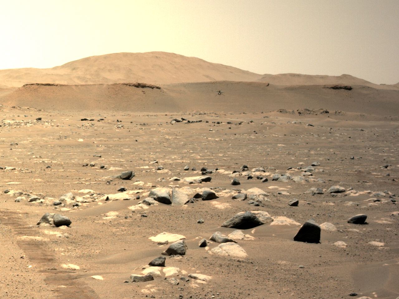
NASA’s Ingenuity Mars Helicopter can be seen hovering during its third flight on April 25, 2021, as seen by the left Navigation Camera aboard NASA’s Perseverance Mars rover. Credit: NASA/JPL-Caltech
On Feb. 18th, 2021, the Perseverance rover landed on Mars carrying the most advanced scientific instruments ever sent to another planet. It also carried experiments designed to push the envelope of exploration and help pave the way for crewed missions to Mars. This includes theIngenuity Mars Helicopter, an experimental flight system designed to see if aerial systems can operate in the Martian atmosphere.
After making its inaugural flight on April 19th, Ingenuity has taken to the air twice more and set many records in the process. During its most recent test flight (which took place on the morning of April 25th), the helicopter flew farther and faster than ever before. All told, the helicopter covered a distance of 50 meters (164 feet) in 80 seconds, reaching a top speed of 2 m/s (6.6 feet per second) or 7.2 km/hour (4.5 mph).
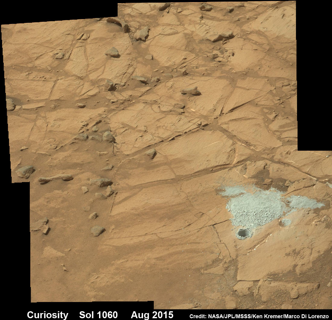
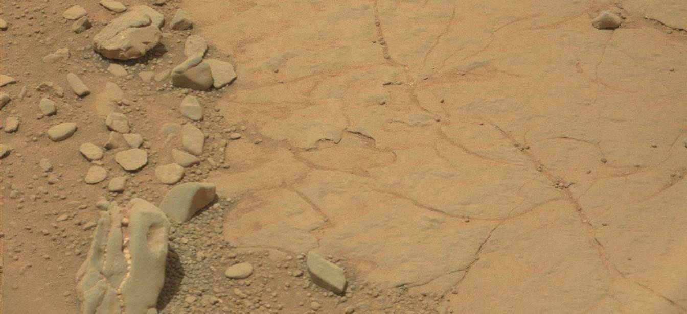
Curiosity extends robotic arm and conducts sample drilling at “Buckskin” rock target at bright toned “Lion” outcrop at the base of Mount Sharp on Mars, seen at right. Gale Crater eroded rim seen in the distant background at left, in this composite multisol mosaic of navcam raw images taken to Sol 1059, July 30, 2015. Navcam camera raw images stitched and colorized. Inset: MAHLI color camera up close image of full depth drill hole at “Buckskin” rock target on Sol 1060. Credit: NASA/JPL-Caltech/MSSS/Ken Kremer/kenkremer.com/Marco Di Lorenzo
Curiosity extends robotic arm and conducts sample drilling at “Buckskin” rock target at bright toned “Lion” outcrop at the base of Mount Sharp on Mars, seen at right, during August 2015. Gale Crater eroded rim seen in the distant background at left, in this composite multisol mosaic of navcam raw images taken to Sol 1059, July 30, 2015. Navcam camera raw images stitched and colorized. Inset: MAHLI color camera up close image of full depth drill hole at “Buckskin” rock target on Sol 1060. Credit: NASA/JPL-Caltech/MSSS/Ken Kremer/kenkremer.com/Marco Di Lorenzo
Story updated[/caption]
NASA’s Curiosity Mars Science Laboratory (MSL) rover has successfully drilled into the first high silica rock target on Mars after recently discovering this new type of rock that’s unlike any found before – as she is about to mark the 3rd anniversary since the hair-raising touchdown on the Red Planet.
The SUV-sized rover bored a full depth hole into a Mars outcrop at a target dubbed “Buckskin” as commanded by the mission team over the weekend, after first conducting a mini drill test to assess the safety of the intended drill campaign to sample the alien rock interior beneath the Martian crater floor.
“This morning, the MSL operations team was very happy to see that drilling into Buckskin was successful!” said Ken Herkenhoff, Research Geologist at the USGS Astrogeology Science Center and an MSL science team member, in a mission update.
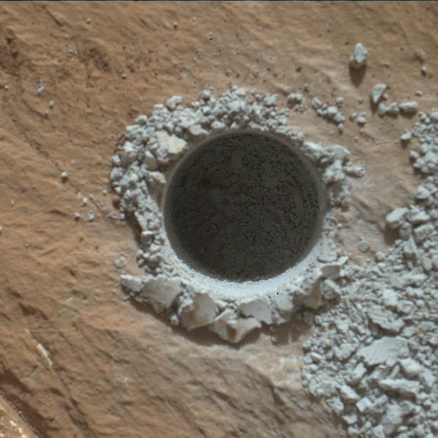
Confirmation of the success of the full depth drilling into “Buckskin” on Sol 1060 at the bright toned “Lion” outcrop came later after receipt of new high resolution images from the rover showing the approximately 1.6 cm (0.63 inch) diameter bore hole next to the initial mini hole test, along with the indicative residue of grey colored tailings from the Martian subsurface seen distributed around the new hole.
“Successful drilling at Buckskin!” added team member Professor John Bridges of the University of Leicester, England, in an update.
“Like the other drill holes this is showing how thin red Mars is,” Bridges elaborated.
Beneath a thin veneer of rusty red colored iron oxide, the Red Planet is remarkably grey as demonstrated by Curiosity’s prior drilling campaigns.
The hole was bored to a full depth of about 2.6 inches (6.5 centimeters) using the percussion drill on the terminus of the 7 foot-long (2.1 meter-long) robotic arm.
Curiosity rover successfully drills into Martian outcrop at Buckskin rock target at current work site at base of Mount Sharp in August 2015, in this mosaic showing full depth drill hole and initial test hole, with grey colored subsurface tailings and mineral veins on surrounding Red Planet terrain. This high resolution photo mosaic is a multisol composite of color images taken by the mast mounted Mastcam-100 color camera up to Sol 1060, July 31, 2015. Credit: NASA/JPL-Caltech/Ken Kremer/kenkremer.com/Marco Di Lorenzo
Buckskin was “chosen because this sedimentary horizon has some very high silica enrichments,” Bridges explains.
The findings of elevated levels of silicon as well as hydrogen were derived from data collected by Curiosity’s laser-firing Chemistry & Camera (ChemCam) and Dynamic Albedo of Neutrons (DAN) instruments on certain local area rocks.
Silica is a rock-forming compound containing silicon and oxygen, commonly found on Earth as quartz.
“High levels of silica could indicate ideal conditions for preserving ancient organic material, if present, so the science team wants to take a closer look,” say mission team officials.
See the rover at work reaching out with her robotic arm and drilling into Buckskin, as illustrated in our new mosaics of mastcam and navcam camera raw images created by the image processing team of Ken Kremer and Marco Di Lorenzo (above and below).
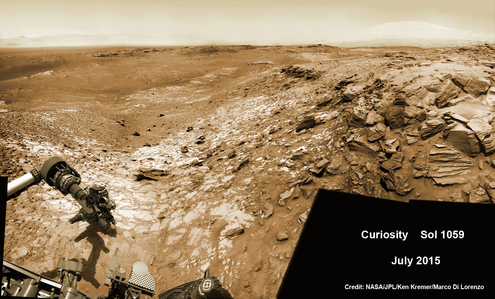
“Buckskin” sits at the base of Mount Sharp, a huge layered mountain that dominates the center of the 96 mile-wide (154 kilometers-wide) Gale Crater landing site.
Exploring the sedimentary layers of Mount Sharp, which towers 3.4 miles (5.5 kilometers) into the Martian sky, is the primary destination and goal of the rovers long term scientific expedition on the Red Planet.
The silica enrichment “may have occurred as the Gale sediments were altered by subsurface fluids after burial. As the basaltic composition was altered (as we saw from the clay and Fe oxide at Yellowknife Bay) ultimately a lot of silica is released which can be precipitated at horizons like this,” explains Bridges.
The Curiosity Mars Science Laboratory (MSL) rover safely touched down on the crater floor on August 5, 2012 following the unprecedented and nail-biting sky crane maneuver that delivered her with pinpoint precision to a landing site nearby Mount Sharp inside Gale Crater.
The goal of the drilling is to provide geologic context for Curiosity’s long term climb up the mountains sedimentary layers by collecting samples to assess the habitability of the Red Planet over billions of years of time.
So the plan was for the robot to process and pulverize the samples for eventual delivery to the onboard pair of miniaturized chemistry labs located inside her belly – SAM and CheMin. Tiny samples are fed to a trio of inlet ports on the rover deck through the sieved filters.
Images are taken to document and assess the entire sample collection and delivery process.
After gathering the Buckskin sample, a portion was transferred to the robots scoop for inspection.
Then the first portion was successfully fed into CheMin for inorganic elemental analysis over the weekend.
“The activities planned for last weekend completed successfully, including sample dropoff to CheMin and analysis of the minerals present,” Herkenhoff confirmed.
The one ton robots next steps involve “dumping the portion of the drill sample that has not been sieved and Mastcam, ChemCam, MAHLI, and APXS observations of the dump pile. ChemCam and Mastcam will also observe nearby targets “Martz” and “Mountain Home.” MAHLI will image the drill hole, tailings and CheMin inlet at night using its LEDs for illumination.”
Curiosity MAHLI camera image taken of Buckskin drill hole on Sol 1060 on July 31, 2015. Credit: NASA/JPL/MSSS
After completing these science activities, the six wheeled rover will move on to the next exciting destination.
“It’s been a great couple of weeks at the Lion outcrop, but it’s time to move on,” says Lauren Edgar, Research Geologist at the USGS Astrogeology Science Center and an MSL science team member, in the latest mission update from today, August 4, Sol 1065.
“After a successful investigation that included observations by almost every science instrument, we’re getting ready to drive away tomorrow. That means that today (and tomorrow before we drive) is the last call for science observations.”
For about the past two months, the six wheeled robot has been driving around and exploring a geological contact zone named “Marias Pass” – an area on lower Mount Sharp, by examining the rocks and outcrops with her suite of state-of-the-art science instruments.
“Marias Pass” is a geological context zone where two rock types overlap – pale mudstone meets darker sandstone.
The prior hole was drilled at Telegraph Peak on Feb. 24, 2015, on Sol 908.
Curiosity recently celebrated 1000 Sols of exploration on Mars on May 31, 2015 – detailed here with our Sol 1000 mosaic also featured at Astronomy Picture of the Day on June 13, 2015.
NASA’s Martian Curiosity rover looks backs to 1000 Sols of science and exploration on the surface of the Red Planet. Robot wheel tracks lead back through valley dunes. Gale Crater rim seen in the distant hazy background. Sol 997 (May 28, 2015) navcam camera raw images stitched and colorized. Credit: NASA/JPL-Caltech/ Marco Di Lorenzo/Ken Kremer/kenkremer.com Featured on APOD on June 13, 2015
As of today, Sol 1065, August 4, 2015, she has driven some 11 kilometers and taken over 256,000 amazing images.
Curiosity has already accomplished her primary objective of discovering a habitable zone on the Red Planet – at the Yellowknife Bay area – that contains the minerals necessary to support microbial life in the ancient past when Mars was far wetter and warmer billions of years ago.
Stay tuned here for Ken’s continuing Earth and planetary science and human spaceflight news.
Curiosity extends robotic arm and conducts test drill at “Buckskin” rock target at bright toned “Lion” outcrop on the lower region of Mount Sharp on Mars, seen at right. Gale Crater eroded rim seen in the distant background at left, in this composite multisol mosaic of navcam raw images taken to Sol 1059, July 30, 2015. Navcam camera raw images stitched and colorized. Credit: NASA/JPL-Caltech/Ken Kremer/kenkremer.com/Marco Di Lorenzo
The dinosaur on Mars, the Face in Cydonia, the rat, the human skull, the Smiley face, the prehistoric vertebrae and the conglomerate rock. Something is amiss in this montage and shouldn't be included. (Photo Credits: NASA/JPL)
What is up with the fossils on Mars? Found – a dinosaur skull on Mars? Discovered – a rat, squirrel or gerbil on Mars? In background of images from Curiosity, vertebrae from some extinct Martian species? And the human skull, half buried in photos from Opportunity Rover. All the images are made of stone from the ancient past and this is also what is called Pareidolia. They are figments of our imaginations, and driven by our interest to be there – on Mars – and to know that we are not alone. Altogether, they make a multitude of web pages and threads across the internet.
Rock-hounds and Martian paleontologists, if only amateur or retired, have found a bounty of fascinating rocks nestled among the rocks on Mars. There are impressive web sites dedicated to each’s eureka moment, dissemination among enthusiasts and presentation for discussion.
NASA scientists have sent the most advanced robotic vehicles to the surface of Mars, to the most fascinating and diverse areas that are presently reachable with our technology and landing skills. The results have been astounding scientifially but also in terms of mysteries and fascination with the strange, alien formations. Some clearly not unlike our own and others that must be fossil remnants from a bygone era – so it seems.
Be sure to explore, through the hyperlinks, many NASA, NASA affiliates’ and third party websites – embedded throughout this article. Also, links to specific websites are listed at the end of the article.
The Dinosaur skull on Mars is actually dated from Martian Sol 297 (June 7, 2013). The imager used to return this was the MASTCAM and an historic array of landscapes, close-ups and selfies has been produced by the Mars Hand Lens Imager (MAHLI). Other MSL Curiosity cameras are the NAVCAM, cameras for navigation, HAZCAM and MARDI camera. The array of images is historic and overwhelming raising more questions than answers including speculative and imaginative “discoveries.” (Photo Credit: NASA/JPL)
The centerpiece of recent interest is the dinosaur skull protruding from the Martian regolith, teeth still embedded, sparkling efferdent white. There are no sockets for these teeth. Dinosaur dentures gave this senior citizen a few extra good years. The jaw line of the skull has no joint or connection point with the skull. So our minds make up the deficits, fill in the blanks and we agree with others and convince ourselves that this is a fossilized skull. Who knows how this animal could have evolved differently.
But evolve it did – within our minds. Referencing online dictionaries [ref], “Pareidolia is the imagined perception of a pattern (or meaning) where it does not actually exist, as in considering the moon to have human features.” I must admit that I do not seek out these “discoveries” on Mars but I enjoy looking at them and there are many scientists at JPL that have the same bent. Mars never fails to deliver and caters to everyone, but when skulls and fossils are seen, it is actually us catering to the everyday images and wishes we hold in our minds.
No one is left out of the imagery returned from the array of NASA’s Martian assets in orbit. Mars exhibits an incredible display of wind swept sand dunes (center photo). (Photo Credits: NASA, Paramount Pictures)
The “Rat on Mars” (main figure, top center) is actually quite anatomically complete and hunkered down, having taken its final gasps of air, eons ago, as some cataclysmic event tore the final vestiges of Earth-like atmosphere off the surface. It died where it once roamed and foraged for … nuts and berries? Surprisingly, no nuts have been found. Blueberries – yes – they are plentiful on Mars and could have been an excellent nutritional source for rats; high in iron and possibly like their Earthly counterpart, high in anti-oxidants.
The Blueberries of Mars are actually concretions of iron rich minerals from water – ground or standing pools – created over thousands of years during periodic epochs of wet climates on Mars. (Photo Credits: NASA/JPL/Cornell)
The blueberries were popularized by Dr. Steve Squyres, the project scientist of the Mars Exploration Rover (MER) mission. Discovered in Eagle crater and across Meridiani Planum, “Blueberries” are spherules of concretions of iron rich minerals from water. It is a prime chapter in the follow-the-water story of Mars. And not far from the definition of Pareidolia, Eagle Crater refers to the incredible set of landing bounces that sent “Oppy” inside its capsule, surrounded by airbags on a hole-in-one landing into that little crater.
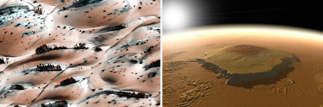
When the global dust storm cleared, Mariner 9’s first landfall was the tip of Olympus Mons, 90,000 feet above its base. Two decades later, Mars Global Surveyors laser altimeter data was used to computer generate this image(NASA Solar System Exploration page). At left are sand dunes near the north pole photographed in 2008 (APOD) by the Mars Reconnaissance Orbiter HiRISE camera. The sand dunes challenge scientists’ understanding of Mars’ geology and meterology while fueling speculation that such features are plants or trees on Mars. (Photo Credit: NASA/JPL)
Next, is the face of Mars of the Cydonia region (Images of Cydonia, Mars, NSSDC). As seen in the morphed images, above, the lower resolution Viking orbiter images presented Mars-o-philes clear evidence of a lost civilization. Then, Washington handed NASA several years of scant funding for planetary science, and not until Mars Global Surveyor, was the Face of Cydonia photographed again. The Mars Orbiter Camera from the University of Arizona delivered high resolution images that dismissed the notion of a mountain-sized carving. Nonetheless, this region of Mars is truly fascinating geologically and does not disappoint those in search of past civilizations.
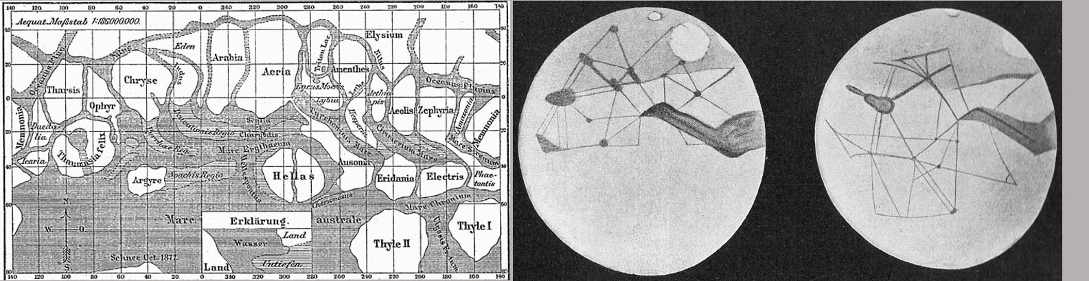
At left, drawings by Italian astronomer Giovanni Schiaparelli coinciding with Mars’ close opposition with Earth in 1877. At right, the drawings of Percival Lowell who built the fine observatory in Flagstaff to support his interest in Mars and the search for a ninth planet. H.G. Wells published his book “War of the Worlds” in 1897. (Image Credits: Wikipedia)
And long before the face on Mars in Cydonia, there were the canals of Mars. Spotted by the Mars observer Schiaparelli, the astronomer described them as “channels” in his native language of Italian. The translation of the word turned to “Canals” in English which led the World to imagine that an advanced civilization existed on Mars. Imagine if you can for a moment, this world without Internet or TV or radio and even seldom a newspaper to read. When news arrived, people took it verbatim. Canals, civilizations – imagine how imaginations could run with this and all that actually came from it. It turns out that the canals or channels of Mars as seen with the naked eye were optical illusions and a form of Pareidolia.
So, as our imagery from Mars continues to return in ever greater detail and depth, scenes of pareidolia will fall to reason and we are left with understanding. It might seem sterile and clinical but its not. We can continue to enjoy these fascinating rocks – dinosaurs, rats, skulls, human figures – just as we enjoy a good episode of Saturday Night Live. And neither the science or the pareidolia should rob us of our ability to see the shear beauty of Mars, the fourth rock from the Sun.
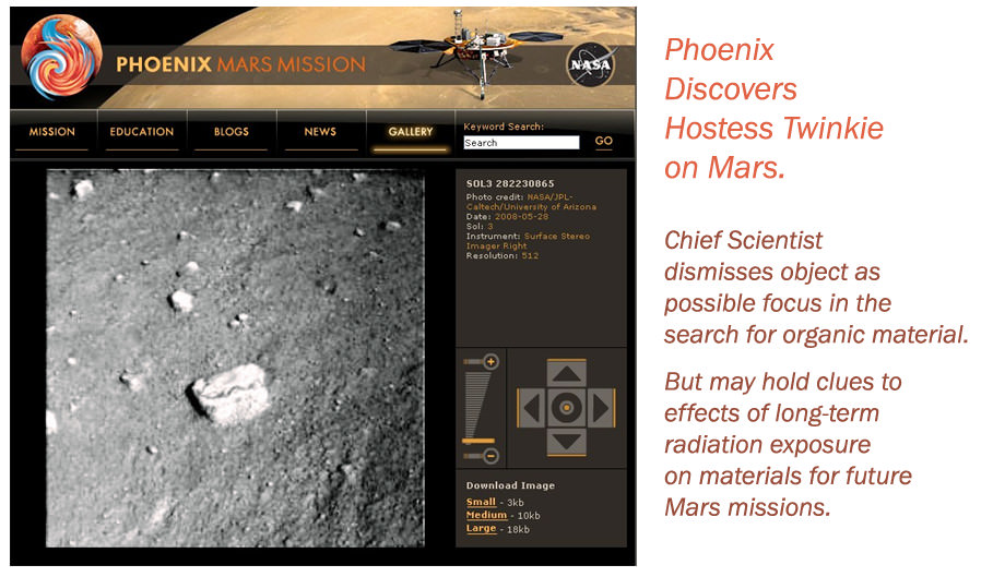
Having supported Mars Phoenix software development including the final reviews of the EDL command sequence, I was keen to watch images arrive from the lander. The image was on an office wall entertaining the appearance of a not-so-tasty junk food item on Mars. (Photo Credit: NASA/JPL/Univ. Arizona, Illustration – T.Reyes)
In the article’s main image, what should not be included is the conglomerate rock on Mars. NASA/JPL scientists and geologists quickly recognized this as another remnant of Martian hydrologics – the flow of water and specifically, the bottom of a stream bed (NASA Rover Finds Old Streambed on Martian Surface). Truly a remarkable discovery and so similar to conglomerate rocks on Earth.
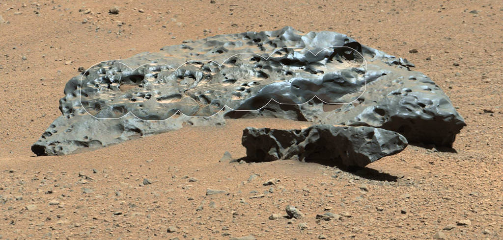
2-meter wide iron meteorite dubbed "Lebanon," as imaged by Curiosity's ChemCam and Mastcam on May 25, 2014
Talk about heavy metal! This shiny, lumpy rock spotted by NASA’s Curiosity rover is likely made mostly of iron — and came from outer space! It’s an iron meteorite, similar to ones found in years past by Curiosity’s forerunners Spirit and Opportunity, but is considerably larger than any of the ones the MER rovers came across… in fact, at 2 meters (6.5 feet) wide this may very well be the biggest meteorite ever discovered on Mars!
Click the image for a supermetallicious high-resolution version from JPL’s Planetary Photojournal.
Original raw Mastcam (right) image of Lebanon and Lebanon B from Sol 640 (NASA/JPL-Caltech/MSSS)
The picture above was made by combining high-resolution circular images (outlined in white) acquired with the Remote Micro-Imager (RMI) of Curiosity’s ChemCam instrument with color and context from the rover’s Mastcam. The images were taken on mission Sol 640 (May 25, 2014) and have been adjusted to simulate more Earth-like illumination.
Dubbed “Lebanon,” the large meteorite has a smaller fragment lying alongside it, named “Lebanon B.”
While iron meteorites are fairly common on Earth, on Mars they are by far the most common types of meteorites that have been discovered — if just for the sheer fact that they are highly resistant to erosion.*
*Note: that isn’t to say iron meteorites can’t be eroded; on the contrary, much of their signature surface sheen and pitted texture comes from various erosion processes. See a related study from J. W. Ashley et al. here.
Afternoon on Mars (MSL Mastcam mosaic)(NASA/JPL-Caltech/MSSS. Edit by Jason Major)
Here’s a pretty picture for your Friday: a mosaic of Mastcam images acquired by Curiosity on mission Sol 582, also known to us Earthlings as Thursday, March 27, 2014. Barsoom sure looks lovely this time of year!
The mosaic was assembled from five raw images downlinked to the MSL site earlier today. I pasted them together in Photoshop, aligning the edge of one to the next using landscape objects as visual markers, and then did a little bad pixel cleanup (Mastcam has a notorious black smudge a few pixels wide just off-center) and then cropped the result, with a bit of surface cloning at the lower right to fill in some missing Martian soil. The I hit it with an HDR filter, which I’m usually not a fan of but in in this instance it turned out pretty nice.
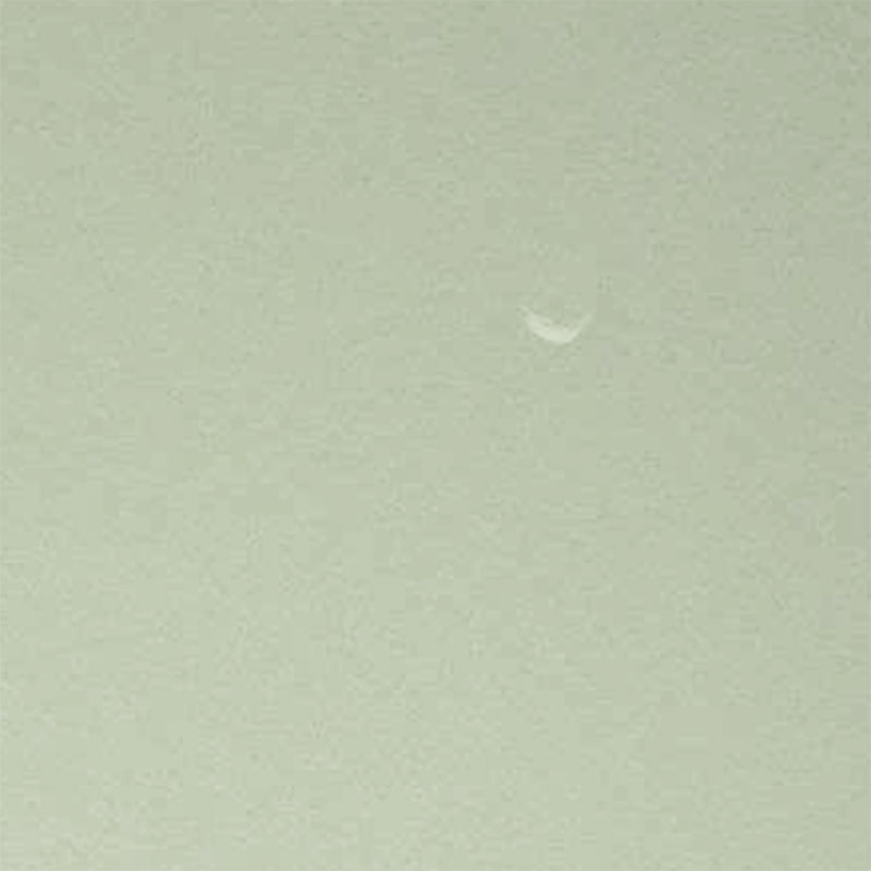
Raw image of Phobos above Mars, taken by Curiosity's Mastcam in September 2012. Credit: NASA/JPL-Caltech
Mars’ moon Phobos is captured in a daytime image by Curiosity (NASA/JPL-Caltech/MSSS)
A raw image taken on September 21 by Curiosity’s right Mastcam shows a daytime view of the Martian sky with a crescent-lit Phobos in the frame… barely visible, yes, but most certainly there. Very cool!
The image above is a crop of the original, contrast-enhanced and sharpened to bring out as much detail as possible.
The 13-km-wide Phobos has been spotted several times before by Mars rovers, most recently during a solar transit on September 13 (sol 37) but I’m not sure if it’s ever been clearly captured on camera during the day before (i.e., not passing in front of the Sun.) If not, this will be a first!
See the latest news from the Curiosity mission here.
Added 9/28: According to Universe Today publisher Fraser Cain, this is “the most dramatic space picture of the year”… whether you agree or not, hear what he had to say on this and other recent news during the September 27 episode of the Weekly Space Hangout.
Yes, Mars gets eclipses too! This brief animation, made from ten raw subframe images acquired with Curiosity’s Mastcam on September 13 — the 37th Sol of the mission — show the silhouette of Mars’ moon Phobos as it slipped in front of the Sun’s limb.
The entire animation spans a real time of about 2 minutes.
As a moon Phobos really is an oddity. In addition to its small size – only 8 miles (13 km) across at its widest – and irregular shape, it also orbits its parent planet at a very low altitude, only 5,840 miles (9,400 km) and thus needs to travel at a relatively high velocity in order to even stay in orbit. Phobos actually orbits Mars over three times faster than Mars rotates, appearing to rise in Mars’ western sky. And its orbit is so low that it can’t even be seen from the polar regions!
Since Phobos, and its even more petite sibling Deimos, are so small, the Mars rovers won’t ever see a total solar eclipse. In fact these events are often referred to as transits rather than actual eclipses.
This isn’t the first time an eclipse was captured by a Mars Exploration Rover; Opportunity witnessed a similar partial eclipse of the Sun by Phobos in December 2010, and Spirit caught a lunar (or “Phobal?”) eclipse on camera back in 2005, when the moon passed into the shadow of Mars.
Curiosity’s find was no accident, either, as mission engineers had the Mastcam already positioned to capture the event. Preparation really pays off!
See the latest images and news from the MSL mission here.
Images: NASA/JPL-Caltech/Malin Space Science Systems. Animation by Jason Major. Inset image: Phobos as seen by Mars Express ESA/DLR/FU Berlin (G. Neukum)
UPDATE 9/19/12: See a close-up animation of the eclipse event here.
Wow — what a view! This image, released today, is a high-resolution shot of the Curiosity rover’s ultimate goal: the stratified flanks of Gale Crater’s 3.4-mile (5.5-km) high central peak, Mount Sharp. The image was taken with Curiosity’s 100mm telephoto Mastcam as a calibration test… if views like this are what we can expect from the MSL mission, all I can say is (and I’ve said it before) GO CURIOSITY!
“This is an area on Mount Sharp where Curiosity will go,” said Mastcam principal investigator Michael Malin of Malin Space Science Systems. “Those layers are our ultimate objective. The dark dune field is between us and those layers. In front of the dark sand you see redder sand, with a different composition suggested by its different color. The rocks in the foreground show diversity — some rounded, some angular, with different histories. This is a very rich geological site to look at and eventually to drive through.”
The gravel-strewn region in the foreground is Curiosity’s immediate landing area. Then the ground dips into a low depression called a swale, then rises up again to the edge of a crater that’s rimmed with larger rocks. Quite a bit beyond that (about 2.2 miles/3.7 km away) are fields of dunes composed of darker material, and then the hummocky base of Mount Sharp itself begins to rise up about 3.4 miles (5.5 km) in the distance.
The topmost ridges of Mount Sharp visible above are actually 10 miles (16.2 km) away.
A crop of the full-size image shows a large rock at the foot of a knoll that’s about the same size as Curiosity (which is this big compared to a person and previous rovers):
The rocky mound just behind the boulder in that image is itself about 1,000 feet (300 meters) across and 300 feet (100 meters) high. Gale Crater isn’t a place for a faint-hearted rover!
The colors have been modified from the original image in order to help better discern landforms and differences in surface materials. Here, the images look more like what we’d see under natural Earthly lighting.
Curiosity already is returning more data from the Martian surface than have all of NASA’s earlier rovers combined.
“We have an international network of telecommunications relay orbiters bringing data back from Curiosity,” said JPL’s Chad Edwards, chief telecommunications engineer for NASA’s Mars Exploration Program. “Curiosity is boosting its data return by using a new capability for adjusting its transmission rate.”
“The knowledge we hope to gain from our observation and analysis of Gale Crater will tell us much about the possibility of life on Mars as well as the past and future possibilities for our own planet. Curiosity will bring benefits to Earth and inspire a new generation of scientists and explorers, as it prepares the way for a human mission in the not too distant future.”
– NASA Administrator Charles Bolden in a message transmitted to the Curiosity rover and then back to Earth, August 27, 2012


