When it comes to the Universe, things often go bump in the night. But whether two galaxies collide, a star explodes in a brilliant supernova, or a meteor hits a massive planet, we tend to catch the aftermath tens to hundreds of thousands of years later.
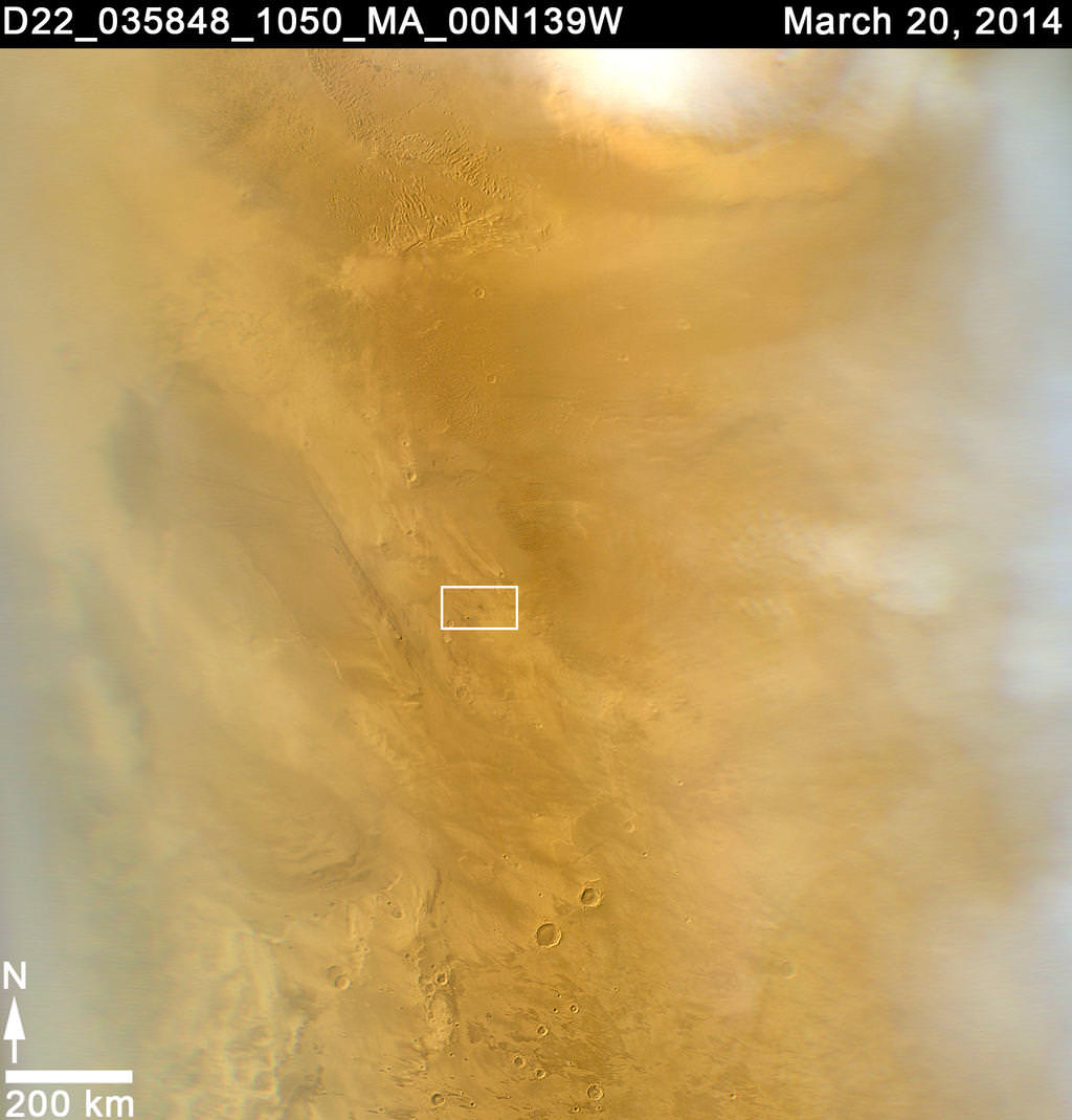
Of course, there’s always an exception to the rule. In today’s news, astronomers using NASA’s Mars Reconnaissance Orbiter have found a fresh meteor-impact crater. And it’s the biggest seen using before-and-after pictures.
When it comes to the red planet, we’ve seen evidence of fresh craters before, but usually the impact can’t be nailed down to better than a few years’ time. The constant sweep of the obiter’s weather-monitoring camera, the Mars Color Imager (MARCI), however, allowed us to pinpoint the impact to within a day.
The orbiter began its systematic observation of Mars in 2006. Ever since, Bruce Cantor, MARCI’s principle investigator, has examined the camera’s daily images, searching for evidence of dust storms and other observable weather events. Cantor’s findings help NASA operators plan for weather events that may be harmful to the solar-powered rover, Opportunity.
Nearly two months ago, Cantor noticed a black smudge — a telltale sign of an impact — on the red planet. “It wasn’t what I was looking for,” Cantor said in a NASA press release. “I was doing my usual weather monitoring and something caught my eye. It looked usual, with rays emanating from a central spot.”
So Cantor dug through earlier images, discovering that the dark spot wasn’t visible on March 27, 2012, but appeared on March 28, 2012.
MARCI is a low resolution camera, which is what allows it to see a large area of Mars constantly. But without a high resolution image, we can’t pick out the details of the impact-like black smudge. So Cantor performed follow-up observations with the orbiter’s telescope Context Camera (CTX) and the High Resolution Imaging Science Experiment (HiRISE).
CTX has imaged nearly the entire surface of Mars at least once during the orbiter’s seven-plus years of observations. It photographed the site of the newly-discovered crater in January 2012, revealing nothing prior to the impact. But two new craters appear in the recent image.
The largest crater is slightly elongated and spans 48.5 by 43.5 meters, roughly half the length of a football field. “The biggest crater is unusual, quite shallow compared to other fresh craters we have observed,” said HiRISE Principal Investigator Alfred McEwen of the University of Arizona, Tucson.
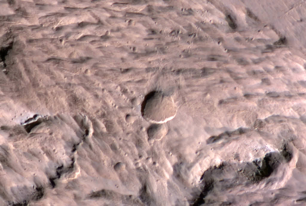
The impacting object is likely a few meters across. Something that small would burn up in the Earth’s atmosphere, but with a much thinner atmosphere (about 1% as thick as Earth’s), Mars lets most debris right on through.
To add to the details, images from HiRISE revealed more than a dozen smaller craters near the two larger ones seen by CTX. It’s likely that Mars’ atmosphere, as thin as it is, supplied enough pressure to break the incoming meteoroid into smaller pieces, leaving multiple impacts behind.
This image from the HiRISE camera, on board NASA’s Mars Reconnaissance Orbiter reveals the two impact craters and many smaller craters around them. Image Credit: NASA / JPL-Caltech / University of Arizona
“Studies of fresh impact craters on Mars yield valuable information about impact rates and about subsurface material exposed by the excavations,” said Leslie Tamppari, deputy project scientist for the Mars Reconnaissance Orbiter mission at NASA’s Jet Propulsion Laboratory. “The combination of HiRISE and CTX has found and examined many of them, and now MARCI’s daily coverage has given great precision about when a significant impact occurred.”
The initial NASA press release can be viewed here.
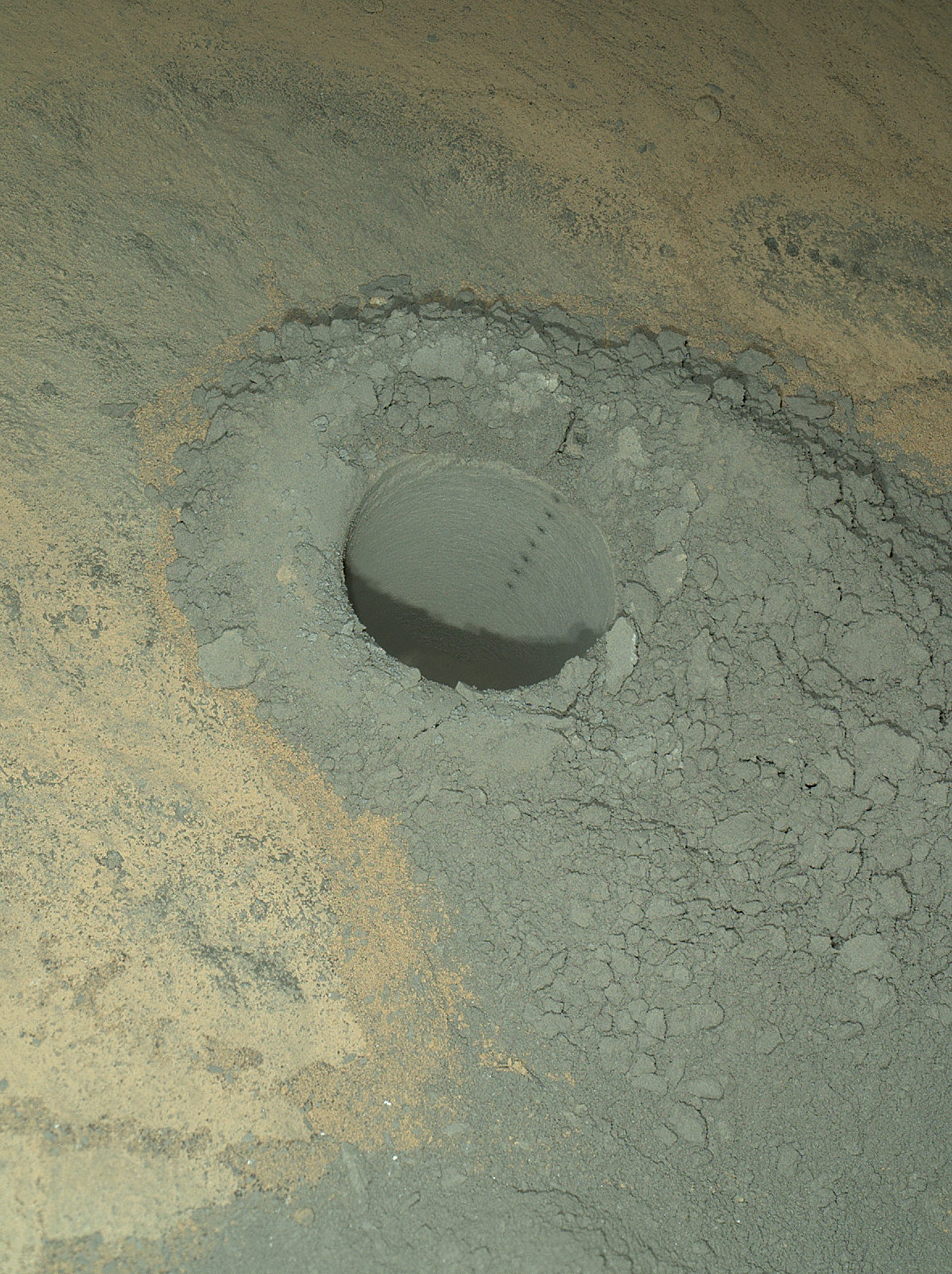
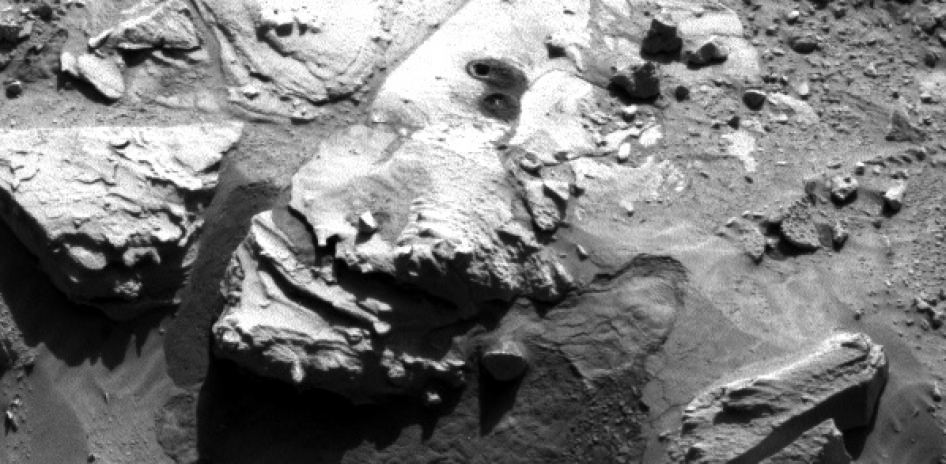
The Mars Hand Lens Imager on NASA's Curiosity Mars rover provided this nighttime view of a hole produced by the rover's drill and, inside the hole, a line of scars produced by the rover's rock-zapping laser. The hole is 0.63 inch (1.6 centimeters) in diameter. The camera used its own white-light LEDs to illuminate the scene on May 13, 2014. Credit: NASA/JPL-Caltech/MSSS
NASA’s rover Curiosity said ‘Goodbye Kimberley’ having fulfilled her objectives of drilling into a cold red sandstone slab, sampling the tantalizing grey colored interior and pelting the fresh bore hole with a pinpoint series of parting laser blasts before seeking new adventures on the road ahead towards the inviting slopes of Mount Sharp, her ultimate destination.
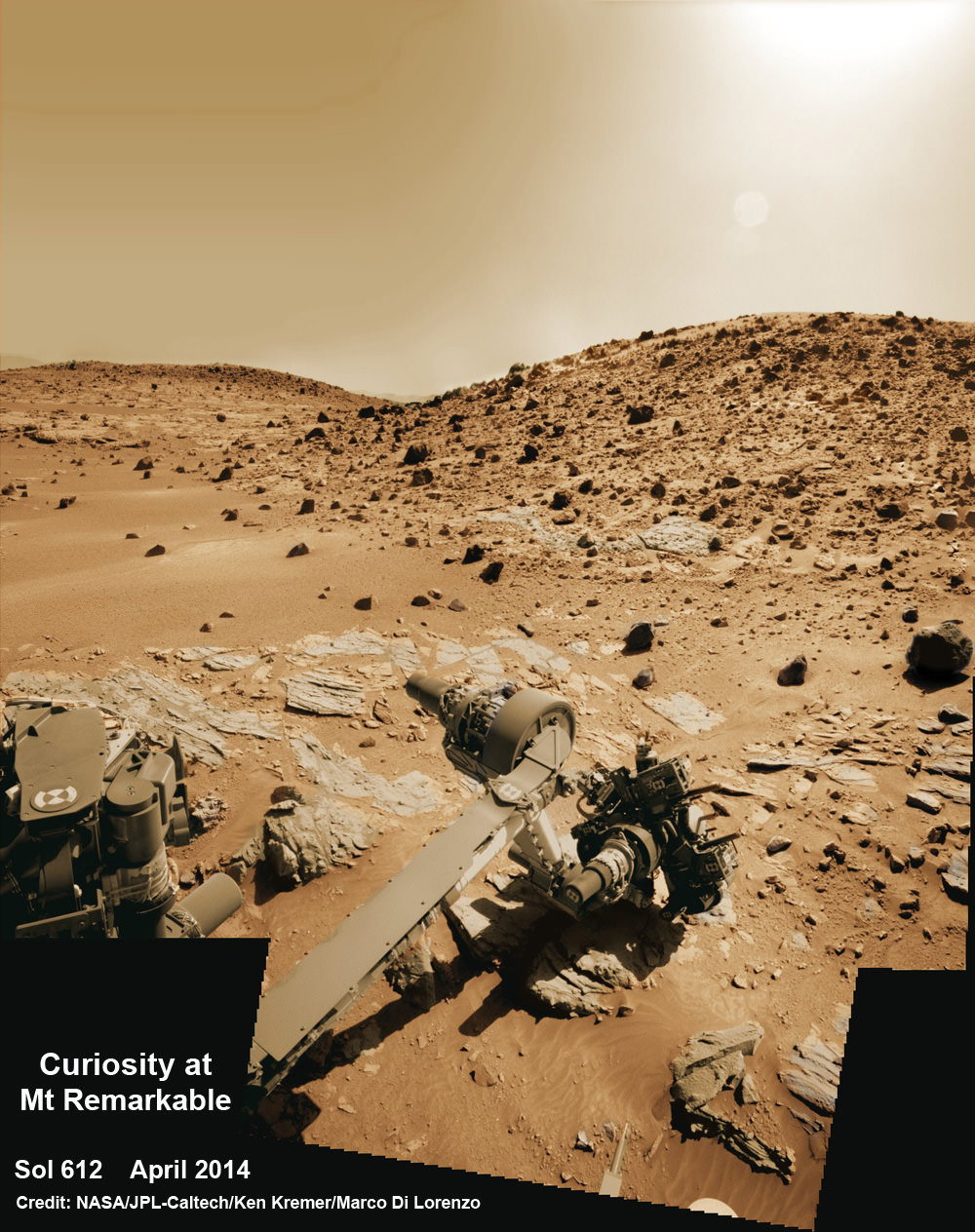
Curiosity successfully drilled her 3rd hole deep into the ‘Windjama’ rock target at the base of Mount Remarkable and within the science waypoint at a region called “The Kimberley” on May 5, Sol 621.
Since then, the 1 ton robot carefully scrutinized the resulting 2.6 inches (6.5 centimeters) deep bore hole and the mound of dark grey colored drill tailings piled around for an up close examination of the texture and composition with the MAHLI camera and spectrometers at the end of her 7-foot-long (2 meters) arm to glean every last drop of science before moving on.
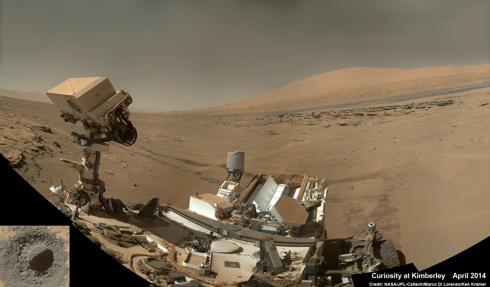
Curiosity’s panoramic view departing Mount Remarkable and ‘The Kimberley Waypoint’ where rover conducted 3rd drilling campaign inside Gale Crater on Mars. The navcam raw images were taken on Sol 630, May 15, 2014, stitched and colorized. Credit: NASA/JPL-Caltech/Ken Kremer – kenkremer.com/Marco Di Lorenzo
Multiple scars clearly visible inside the drill hole and on the Martian surface resulting from the million watt laser firings of the Mast mounted Chemistry and Camera (ChemCam) instrument left no doubt of Curiosity’s capabilities or intentions.
Furthermore she successfully delivered pulverized and sieved samples to the pair of onboard miniaturized chemistry labs; the Chemistry and Mineralogy instrument (CheMin) and the Sample Analysis at Mars instrument (SAM) – for chemical and compositional analysis.
Curiosity completed an “intensive investigation of ‘The Kimberley’, having successfully drilled, acquired and dropped samples into CheMin and SAM,” wrote science team member Ken Herkenhoff in an update.
“MAHLI has taken lots of excellent images of the drill hole, including some during the night with LEDs on, nicely showing the ChemCam LIBS spots.”
“The initial analysis of this new sample by Chemin is ongoing, requiring repeated overnight integration to build up high-quality data,” says Herkenhoff.
The rover’s earth bound handlers also decided that one drill campaign into Kimberley was enough.
So the rover will not be drilling into any other rock targets here.
Composite photo mosaic shows deployment of NASA Curiosity rovers robotic arm and two holes after drilling into ‘Windjana’ sandstone rock on May 5, 2014, Sol 621, at Mount Remarkable as missions third drill target for sample analysis by rover’s chemistry labs. The navcam raw images were stitched together from several Martian days up to Sol 621, May 5, 2014 and colorized. Credit: NASA/JPL-Caltech/Ken Kremer – kenkremer.com/Marco Di Lorenzo
And it may be a very long time before the next drilling since the guiding team of scientists and engineers wants desperately to get on and arrive at the foothills of Mount Sharp as soon as possible.
But the robot will undoubtedly be busy with further analysis of the ‘Windjana’ sample along the way, since there’s plenty of leftover sample material stored in the CHIMRA sample processing mechanism to allow future delivery of samples when the rover periodically pauses during driving.
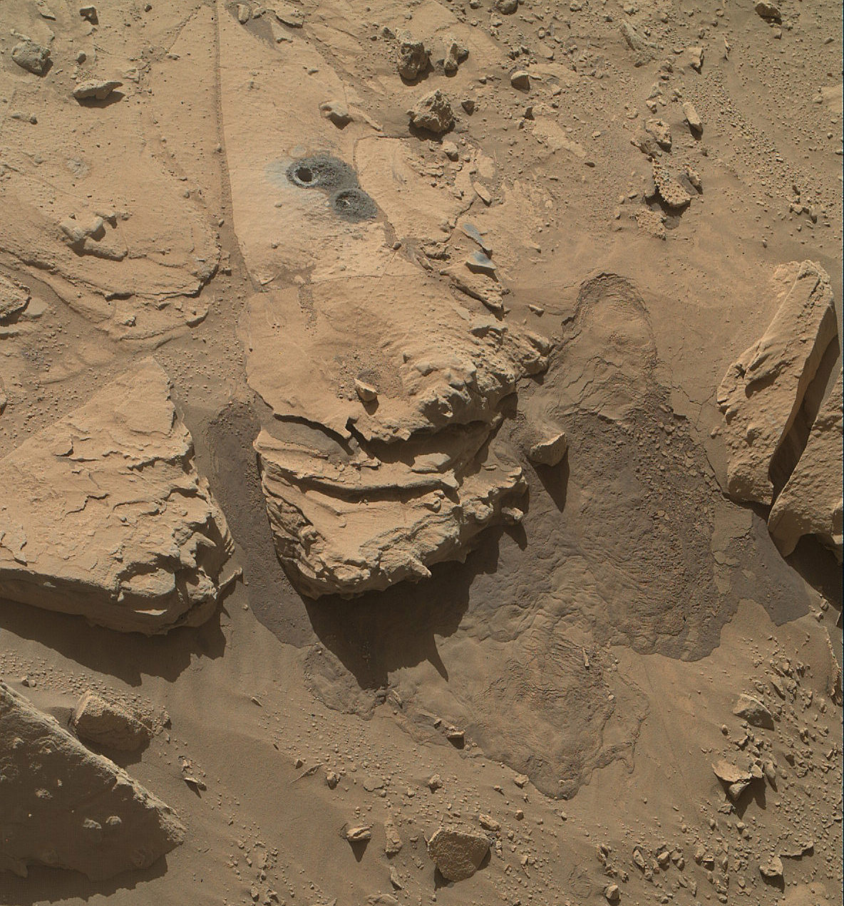
This May 12, 2014, view from the Mars Hand Lens Imager (MAHLI) in NASA’s Curiosity Mars Rover shows the rock target “Windjana” and its immediate surroundings after inspection of the site by the rover by drilling and other activities. Credit: NASA/JPL-Caltech/MSSS
“Windjana” is named after a gorge in Western Australia.
It’s been a full year since the first two drill campaigns were conducted during 2013 at the ‘John Klein’ and ‘Cumberland’ outcrop targets inside Yellowknife Bay. They were both mudstone rock outcrops and the interiors were markedly different in color.
“The drill tailings from this rock are darker-toned and less red than we saw at the two previous drill sites,” said Jim Bell of Arizona State University, Tempe, deputy principal investigator for Curiosity’s Mast Camera (Mastcam).
“This suggests that the detailed chemical and mineral analysis that will be coming from Curiosity’s other instruments could reveal different materials than we’ve seen before. We can’t wait to find out!”
The science team chose Windjana for drilling “to analyze the cementing material that holds together sand-size grains in this sandstone,” says NASA.
Curiosity’s Panoramic view of Mount Remarkable at ‘The Kimberley Waypoint’ where rover conducted 3rd drilling campaign inside Gale Crater on Mars. The navcam raw images were taken on Sol 603, April 17, 2014, stitched and colorized. Credit: NASA/JPL-Caltech/Ken Kremer – kenkremer.com/Marco Di Lorenzo
Featured on APOD – Astronomy Picture of the Day on May 7, 2014
“The Kimberley Waypoint was selected because it has interesting, complex stratigraphy,” Curiosity Principal Investigator John Grotzinger, of the California Institute of Technology, Pasadena, told me.
Curiosity departed the ancient lakebed at the Yellowknife Bay region in July 2013 where she discovered a habitable zone with the key chemical elements and a chemical energy source that could have supported microbial life billions of years ago – and thereby accomplished the primary goal of the mission.
Windjama lies some 2.5 miles (4 kilometers) southwest of Yellowknife Bay.
Curiosity still has about another 4 kilometers to go to reach the foothills of Mount Sharp sometime later this year.
The sedimentary layers of Mount Sharp, which reaches 3.4 miles (5.5 km) into the Martian sky, is the six wheeled robots ultimate destination inside Gale Crater because it holds caches of water altered minerals. Such minerals could possibly indicate locations that sustained potential Martian life forms, past or present, if they ever existed.
Stay tuned here for Ken’s continuing Curiosity, Opportunity, Orion, SpaceX, Boeing, Orbital Sciences, LADEE, MAVEN, MOM, Mars and more planetary and human spaceflight news.
Where did Mars’ moons Phobos and Deimos come from? How did they end up in orbit around Mars? This cool video from the folks at Kurzgesagt answers the most-oft asked questions about these mini moons.
You should also check out their other wonderful videos, like the one about our own Moon, below, which explains how big our Moon really is. The answer might surprise you.
Composite photo mosaic shows deployment of NASA Curiosity rovers robotic arm and two holes after drilling into ‘Windjana’ sandstone rock on May 5, 2014, Sol 621, at Mount Remarkable as missions third drill target for sample analysis by rover’s chemistry labs. The navcam raw images were stitched together from several Martian days up to Sol 621, May 5, 2014 and colorized. Credit: NASA/JPL-Caltech/Ken Kremer - kenkremer.com/Marco Di Lorenzo
Composite photo mosaic shows deployment of NASA Curiosity rovers robotic arm and two holes after drilling into ‘Windjana’ sandstone rock on May 5, 2014, Sol 621, at Mount Remarkable as missions third drill target for sample analysis by rover’s chemistry labs. The navcam raw images were stitched together from several Martian days up to Sol 621, May 5, 2014 and colorized. Credit: NASA/JPL-Caltech/Ken Kremer – kenkremer.com/Marco Di Lorenzo
See additional Curiosity mosaics below-See our APOD featured on May 7, 2014[/caption]
After a rather satisfying test bore into a sandstone slab at “Kimberley” just last week, NASA’s rover Curiosity decided to go all the way for a deep drill excursion into the Red Planet rock target called “Windjana” and successfully collected powdery samples from the interior on Monday evening, May 5, Sol 621, that the rover will soon consume inside her belly for high tech compositional analysis with her state-of-the-art science instruments.
NASA reported the great news today, Tuesday, May 6, soon after receiving confirmation of the successful acquisition effort by the hammering drill, located at the terminus of the 1 ton robots 7-foot-long (2 meter) arm.
At long last its “Drill, Baby, Drill” time on Mars.
The “Kimberley Waypoint” drill campaign into “Windjana” at the Mount Remarkable butte thus marks only the third Martian rock bored for sampling analysis by the SUV sized rover. This also counts as a new type of Mars rock – identified as sandstone, compared to the pair of mudstone rocks bored into last year.
This May 5, 2014, image (Sol 621) from the Navigation Camera on NASA’s Curiosity Mars rover shows two holes at top center drilled into a sandstone target called “Windjana.” The farther hole was created by the rover’s drill while it collected rock-powder sample material from the interior of the rock that will be fed to the rovers chemistry labs for analysis. Credit: NASA/JPL-Caltech
The fresh hole in “Windjana” created on Monday night was clearly visible in images received this afternoon and showed it was 0.63 inch (1.6 centimeters) in diameter and about 2.6 inches (6.5 centimeters) deep.
The operation went exactly as planned and left behind a residual pile of drill tailings much darker in color compared to the ubiquitous red color seen covering most of Mars surface.
The new full-depth hole is very close in proximity to the shallower “Mini-drill” test hole operation carried out on April 29 at Windjama to determine if this site met the science requirements for sampling analysis and delivery to the two onboard, miniaturized chemistry labs – SAM and CheMin.
“Windjana” is named after a gorge in Western Australia.
Curiosity’s Panoramic view of Mount Remarkable at ‘The Kimberley Waypoint’ where rover will conduct 3rd drilling campaign inside Gale Crater on Mars. The navcam raw images were taken on Sol 603, April 17, 2014, stitched and colorized. Credit: NASA/JPL-Caltech/Ken Kremer – kenkremer.com/Marco Di Lorenzo
Featured on APOD – Astronomy Picture of the Day on May 7, 2014
“The drill tailings from this rock are darker-toned and less red than we saw at the two previous drill sites,” said Jim Bell of Arizona State University, Tempe, deputy principal investigator for Curiosity’s Mast Camera (Mastcam).
“This suggests that the detailed chemical and mineral analysis that will be coming from Curiosity’s other instruments could reveal different materials than we’ve seen before. We can’t wait to find out!”
In coming days, the sample will be pulverized and sieved prior to delivery to the Chemistry and Mineralogy instrument (CheMin) and the Sample Analysis at Mars instrument (SAM) for chemical and compositional analysis.
Windjana is an outcrop of sandstone located at the base of a Martian butte named Mount Remarkable at “The “Kimberley Waypoint” – a science stopping point reached by the rover in early April 2014 halfway along its epic trek to towering Mount Sharp, the primary destination of the mission.
See herein our illustrative photo mosaics of the Kimberly Waypoint region assembled by the image processing team of Marco Di Lorenzo and Ken Kremer.
Multisol composite photo mosaic shows deployment of Curiosity’s rovers robotic arm and APXS X-ray spectrometer onto the ‘Winjana’ rock target at Mount Remarkable for evaluation as missions third drill target inside Gale Crater on Mars. The colorized navcam raw images were stitched together from several Martian days up to Sol 612, April 26, 2014. Credit: NASA/JPL-Caltech/Ken Kremer – kenkremer.com/Marco Di Lorenzo
The first two drill campaigns conducted during 2013 at ‘John Klein’ and ‘Cumberland’ inside Yellowknife Bay were on mudstone rock outcrops.
The science team chose Windjana for drilling “to analyze the cementing material that holds together sand-size grains in this sandstone,” says NASA.
“The Kimberley Waypoint was selected because it has interesting, complex stratigraphy,” Curiosity Principal Investigator John Grotzinger, of the California Institute of Technology, Pasadena, told me.
Curiosity snaps selfie at Kimberley waypoint with towering Mount Sharp backdrop on April 27, 2014 (Sol 613). Inset shows MAHLI camera image of rovers mini-drill test operation on April 29, 2014 (Sol 615) into “Windjana” rock target at Mount Remarkable butte. MAHLI color photo mosaic assembled from raw images snapped on Sol 613, April 27, 2014. Credit: NASA/JPL/MSSS/Marco Di Lorenzo/Ken Kremer – kenkremer.com
Curiosity departed the ancient lakebed at the Yellowknife Bay region in July 2013 where she discovered a habitable zone with the key chemical elements and a chemical energy source that could have supported microbial life billions of years ago – and thereby accomplished the primary goal of the mission.
Windjama is about 2.5 miles (4 kilometers) southwest of Yellowknife Bay.
Curiosity still has about another 4 kilometers to go to reach the base of Mount Sharp sometime later this year.
Martian landscape with rows of curved rock outcrops at ‘Kimberly’ in the foreground and spectacular Mount Sharp on the horizon. NASA’s Curiosity Mars rover pulled into Kimberly waypoint dominated by layered rock outcrops as likely drilling site. This colorized navcam camera photomosaic was assembled from imagery taken on Sol 576 (Mar. 20, 2014). Credit: NASA/JPL-Caltech/Marco Di Lorenzo/Ken Kremer-kenkremer.com
The sedimentary foothills of Mount Sharp, which reaches 3.4 miles (5.5 km) into the Martian sky, is the 1 ton robots ultimate destination inside Gale Crater because it holds caches of water altered minerals. Such minerals could possibly indicate locations that sustained potential Martian life forms, past or present, if they ever existed.
Stay tuned here for Ken’s continuing Curiosity, Opportunity, Chang’e-3, SpaceX, Orbital Sciences, LADEE, MAVEN, MOM, Mars and more planetary and human spaceflight news.
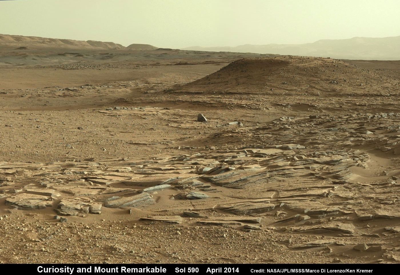
Curiosity scans scientifically intriguing rock outcrops of gorgeous Martian terrain at ‘The Kimberley’ waypoint in search of next drilling location beside Mount Remarkable butte, at right. Mastcam color photo mosaic assembled from raw images snapped on Sol 590, April 4, 2014. Credit: NASA/JPL/MSSS/Marco Di Lorenzo/Ken Kremer – kenkremer.com
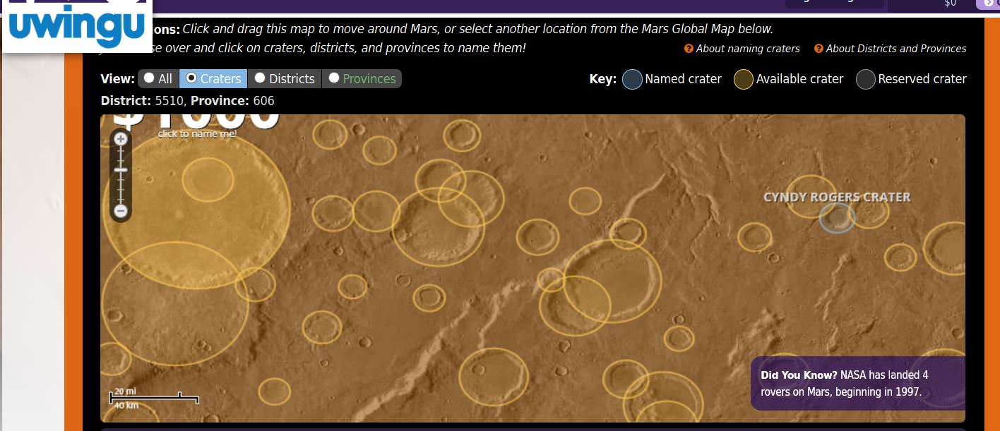
Screenshot from Uwingu's crater naming project on Mars. Click to access the special Mother's Day campaign.
There’s a great book (and a not as great movie) called “Mars Needs Moms” . It’s a heartwarming (dare I say tear-jerking) story that provides a Martian’s-eye view of how important Moms are, and that they’ll love us “to the ends of the universe.”
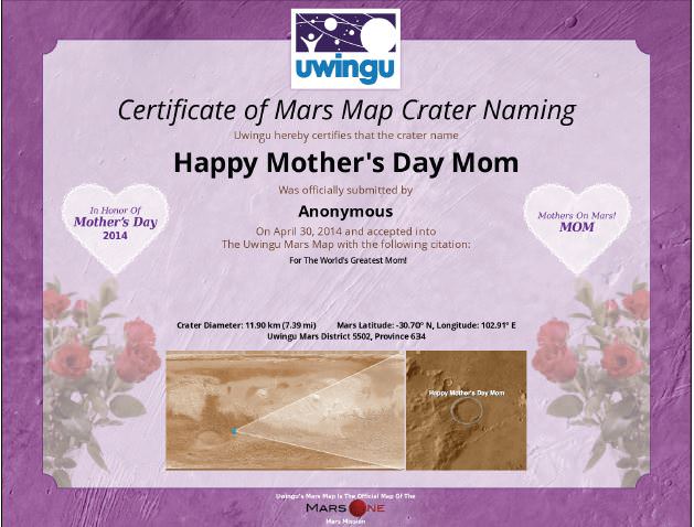
With Mother’s Day coming up — and if you’re looking for another great combination of Moms and Mars — Uwingu is celebrating with a campaign called Mothers on Mars (MoM), which provides the first-ever opportunity to honor Moms on Mother’s Day by naming a feature for her on Uwingu’s new Mars map.
Until Mother’s Day, May 11, Uwingu is offering a gift pack which includes a special Mother’s Day certificate.
Although the crater names likely won’t officially be approved by the IAU, the names will be used on maps used by the Mars One team, the commercial company that is looking to create a human settlement on Mars by 2023.
Planetary scientist and Uwingu’s CEO Dr. Alan Stern said the named craters will be similar to the names given to features on Mars by the mission science teams (such as Mt. Sharp on Mars –the IAU-approved name is Aeolis Mons) or even like Pike’s Peak, a mountain in Colorado which was named by the public — in a way — as early settlers started calling it that, and it soon became the only name people recognized.
Uwingu’s Mars Map Crater Naming Project allows anyone to help name the approximately 590,000 unnamed, scientifically cataloged craters on Mars, starting at $5 each.
Uwingu is hoping to raise $10 million for The Uwingu Fund, which provides grants to further space exploration, research and education.
With almost 10,000 craters named so far, true to their promise, Uwingu has already funded grants to projects and organizations including the Astronomers Without Borders, Students for the Exploration and Development of Space, Mars One mission, the Galileo Teacher Training Program, Explore Mars and the Allen Telescope Array at SETI.
“Our mission is to raise funds for space research while growing a successful company that gets people excited about space exploration and education”, said Stern, the former director of planetary science at NASA.
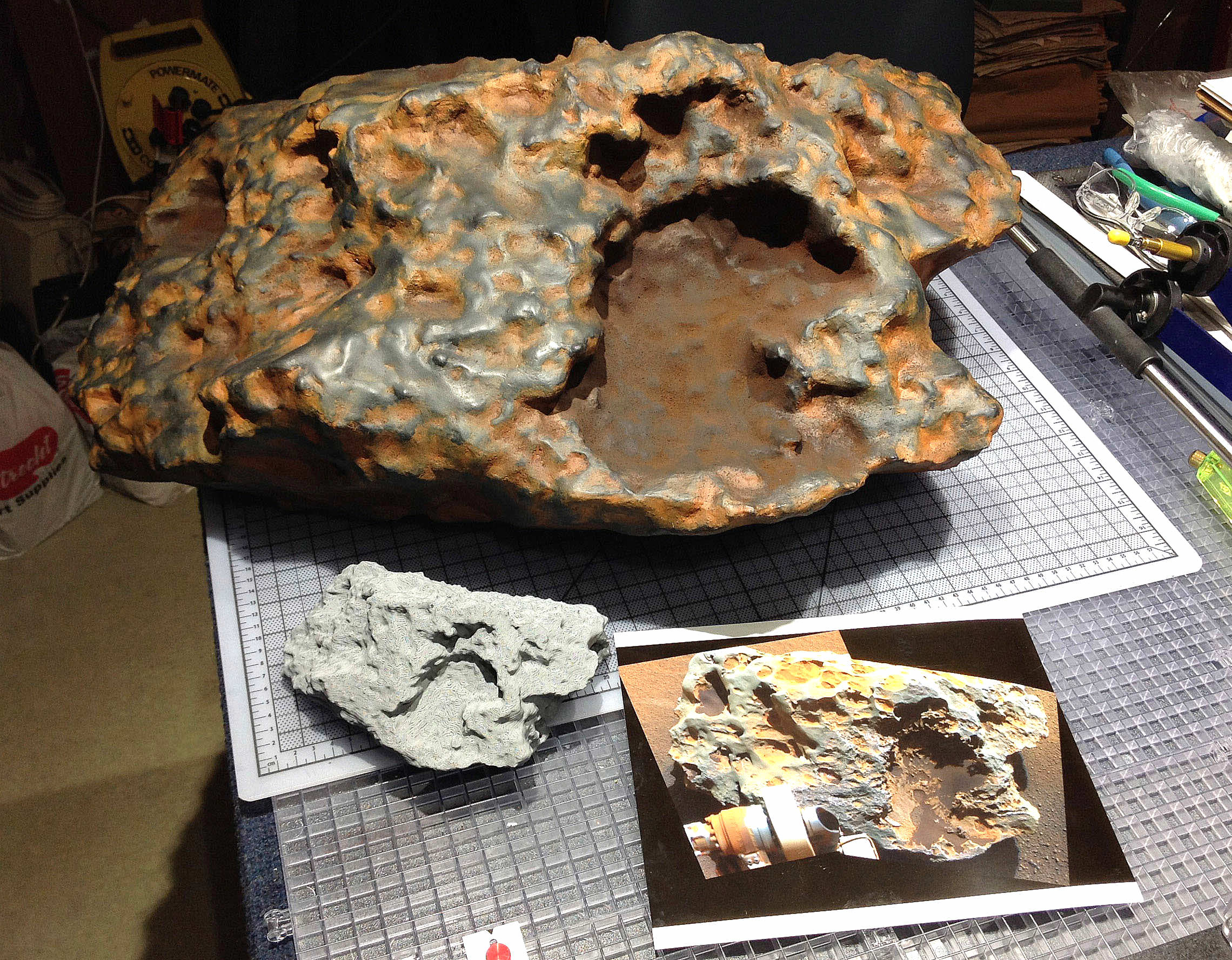
The 'Block Island' meteorite reproduced in plastic at NASA’s Jet Propulsion Laboratory. Credit: NASA/JPL-Caltech
Captain Picard orders tea
“Tea, Earl Grey, hot.” Who doesn’t remember that famous command by Captain Picard’s of TV’s “Star Trek: The Next Generation”? While no one’s yet invented a replicator that can brew a cup of tea out of thin air, scientists have taken in step in that direction by creating an amazing replica of a Martian meteorite using a 3D printer.
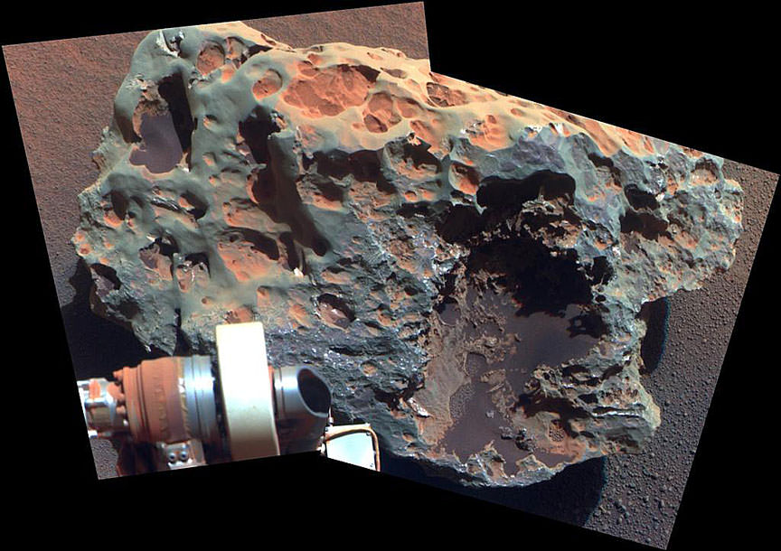
Without the fuss and expense of a sample retrieving mission to Mars, NASA scientists now have a realistic, true to life facsimile of the ‘Block Island’ meteorite discovered by the Opportunity Rover in 2009. Block Island, an iron-nickel meteorite similar to those found at Meteor Crater in Arizona, is the largest meteorite found on the Red Planet.
The real Block Island, the largest meteorite yet found on Mars, photographed by Opportunity’s panoramic camera.Credit: NASA/JPL-Caltech/Cornell
Measuring about two feet (60 cm) across, it’s about the size of picnic cooler and weighs an estimated 1,000 pounds. The replica’s made of plastic – you could tote it around like a … picnic cooler.
Analysis of Block Island’s composition using the rover’s alpha particle X-ray spectrometer confirmed that it’s rich in iron and nickel. Scientists based the design of the plastic meteorite on detailed measurements and stereo images taken by Opportunity’s panoramic camera.
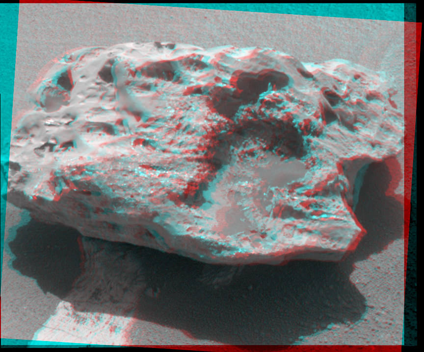
Get out your red-blue plastic glasses to get a look at Block Island in stereo. Credit: NASA/JPL-Caltech
The rover made a 360-degree study of the meteorite five years ago taking measurements and many stereo images. But because Opportunity couldn’t see every square inch of the rock, the missing data created holes in the computer model, making it a poor candidate for 3D printing.
Last summer, scientists got around that problem by filling in the missing data and building small scale models of Block Island. To build the life-sized rock, they created depth meshes of the meteorite’s surface from six positions, then combined them into a three-dimensional digital model, according to researcher Kris Capraro of NASA’s Jet Propulsion Laboratory.
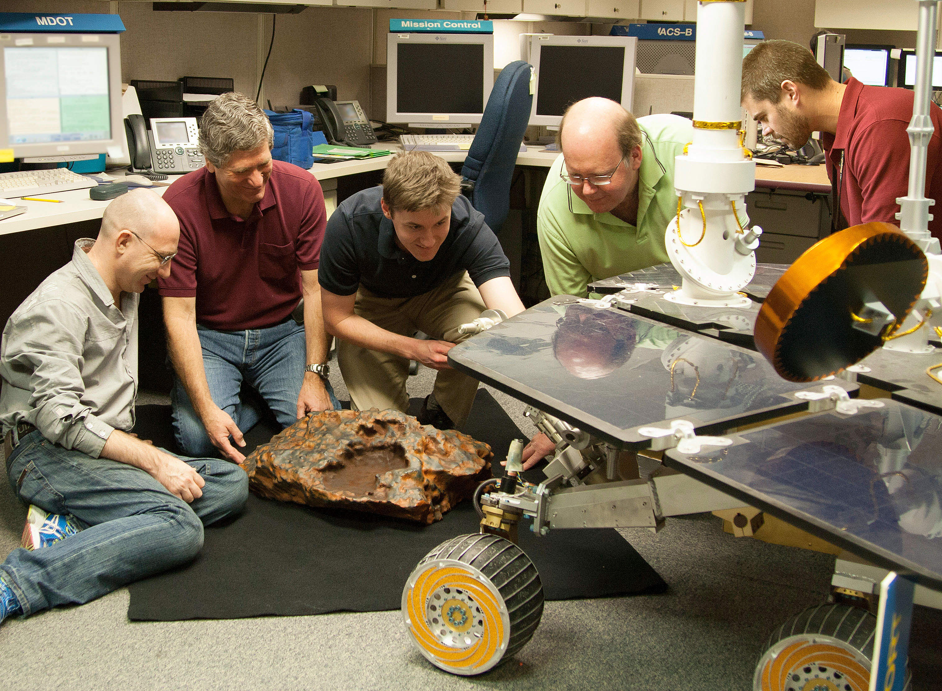
Researcher Kris Capraro (second from left) adds the finishing touches of realistic color to a model of the “Block Island” meteorite.Credit: NASA/JPL-Caltech
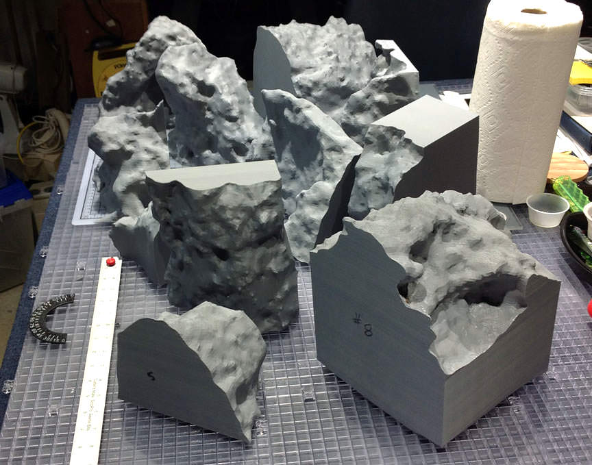
The printer built the meteorite from ABS plastic, the same material used in Lego bricks, with cord the width of the plastic line in your weed-whacker. One small problem remained before the replica could be executed – it was too big to fit in the printer’s building space. So researchers broke up the computer model of the meteorite into 11 sections. Printing took 305 hours and 36 minutes.
Researchers created each of 11 pieces in the 3D printer and glued them together to build the true-size model. Credit: NASA/JPL-Caltech
The sections were assembled and then painted to match the real rock. Said Capraro: “it’s the next best thing to bringing back real Martian rock samples back to Earth.”
Scientists hope someday to use 3D printing to not only replicate more Mars rocks but terrains across the solar system.
Hosts: Fraser Cain and Scott Lewis
Astronomers: Gary Gonella, Andrew Dumbleton, Stuart Foreman, David Dickinson, Shahrin Ahmad and special guest Henna Khan from Bombay, India
Tonight’s Views:
the Moon’s surface
M44 Beehive Cluster
Neutron Star B224 from HST
All-Sky View
Mars with ice caps and Hellas Basin visible
Comet C/2012 K1 PanSTARRS
Stuart demonstrating how to work with software to process images
M51a Whirlpool Galaxy
M53 Globular Cluster
Rosette Nebula – NGC 2237, 2238, 2239 and 2246
Saturn
Horsehead Nebula (Barnard 33 in emission nebula IC 434) and Flame Nebula (NGC 2024) with a satellite trail
NGC 5139 Omega Centauri
M42 Orion Nebula
M63 Sunflower Galaxy
NGC 7635 Bubble Nebula
Large and Small Magellanic Clouds
We hold the Virtual Star Party every Sunday night as a live Google+ Hangout on Air. We begin the show when it gets dark on the West Coast. If you want to get a notification, make sure you circle the Virtual Star Party on Google+. You can watch on our YouTube channel or here on Universe Today.
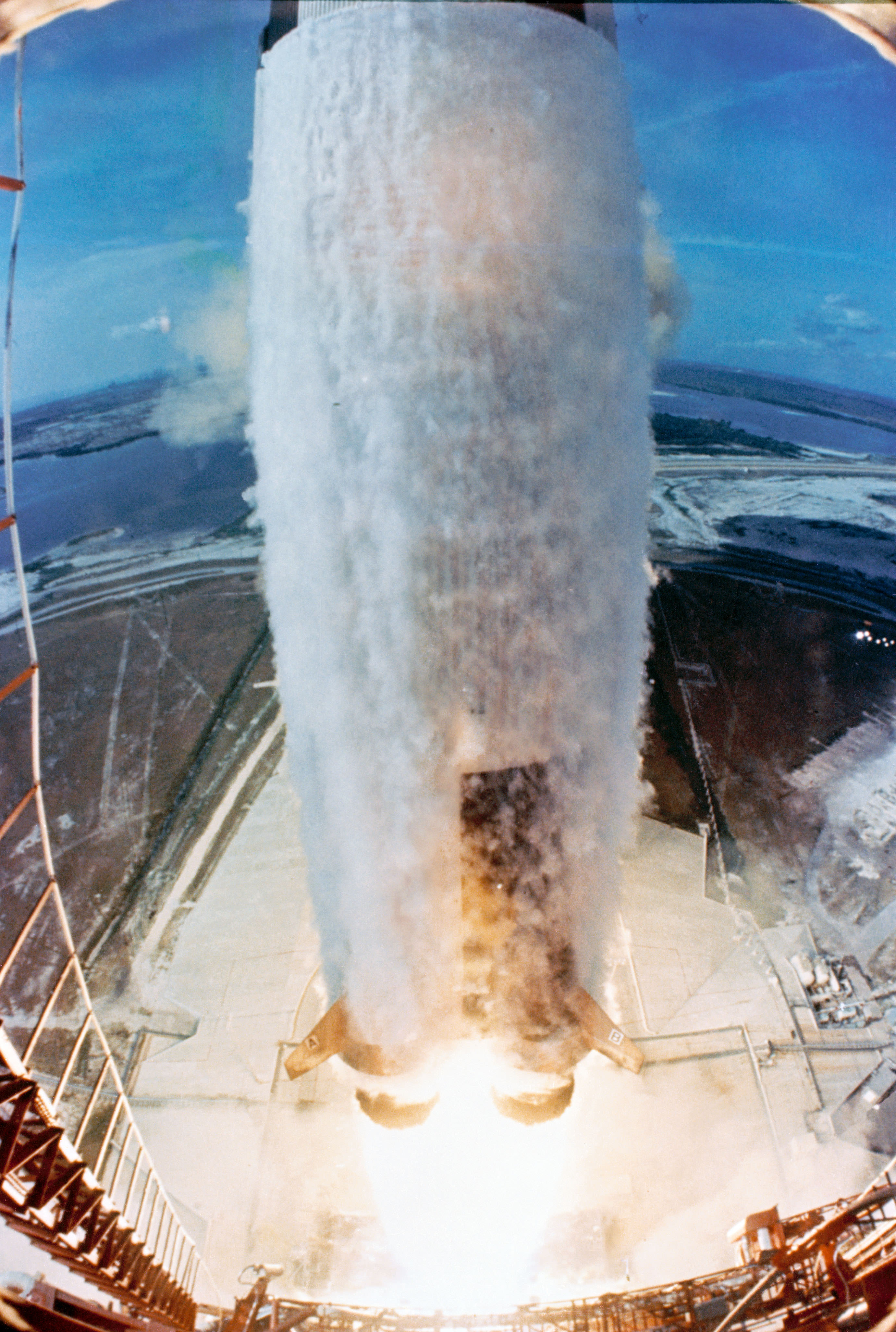
The Saturn V rocket bearing Apollo 11 lifts off from the Kennedy Space Center on July 20, 1969. Credit: NASA
A moon rocket thundering from a pad in Florida. Two moons discovered around Mars. Space tourism. These are all things that are part of history today — and which were also predicted in literature years or decades before the event actually happened.
This fun infographic (embedded below) shows a series of fiction books that were curiously prescient about our future, ranging from From The Earth to the Moon to 2001: A Space Odyssey. Submarines, rocket ships and other pieces of technology were all imagined long before they were reality, so what inspired these authors?
“Many writers of the past have predicted the facts of our present society with a level of detail that seems impossibly accurate,” wrote Printerinks, a print and toner shop that produced the graphic.
“Some of them were even derided in their times for what were called outlandish and unbelievable fictions. Yet their imaginations were in reality painting portraits that would eventually be mirrored by history books a century later. Which seems to beg the question, Where does inspiration come from? So to decide for yourself whether these writers were seers or just plain lucky, explore our History of Books that Predicted the Future.”
You can click on the graphic for a larger version. Is it missing anything? Let us know in the comments.
Curiosity snaps selfie at Kimberley waypoint with towering Mount Sharp backdrop on April 27, 2014 (Sol 613). Inset shows MAHLI camera image of rovers mini-drill test operation on April 29, 2014 (Sol 615) into “Windjama” rock target at Mount Remarkable butte. MAHLI color photo mosaic assembled from raw images snapped on Sol 613, April 27, 2014. Credit: NASA/JPL/MSSS/Marco Di Lorenzo/Ken Kremer - kenkremer.com
Curiosity snaps selfie at Kimberley waypoint with towering Mount Sharp backdrop on April 27, 2014 (Sol 613). Inset shows MAHLI camera image of rovers mini-drill test operation on April 29, 2014 (Sol 615) into “Windjana” rock target at Mount Remarkable butte. MAHLI color photo mosaic assembled from raw images snapped on Sol 613, April 27, 2014. Credit: NASA/JPL/MSSS/Marco Di Lorenzo/Ken Kremer – kenkremer.com See more Curiosity photo mosaics below[/caption]
The answer has come Fast and Furious – “Drill, Baby, Drill !”
After spending the weekend inspecting an enticing slab of sandstone rock at “Kimberley”, the team directed NASA’s Curiosity rover to bore a test hole into a Martian rock target called “Windjana” on Tuesday, April 29, Sol 615, that exhibited interesting bumpy textures. See above our illustrative “Kimberley” photo mosaic.
“A decision about full drilling is planned in coming days,” NASA JPL press officer Guy Webster told me today.
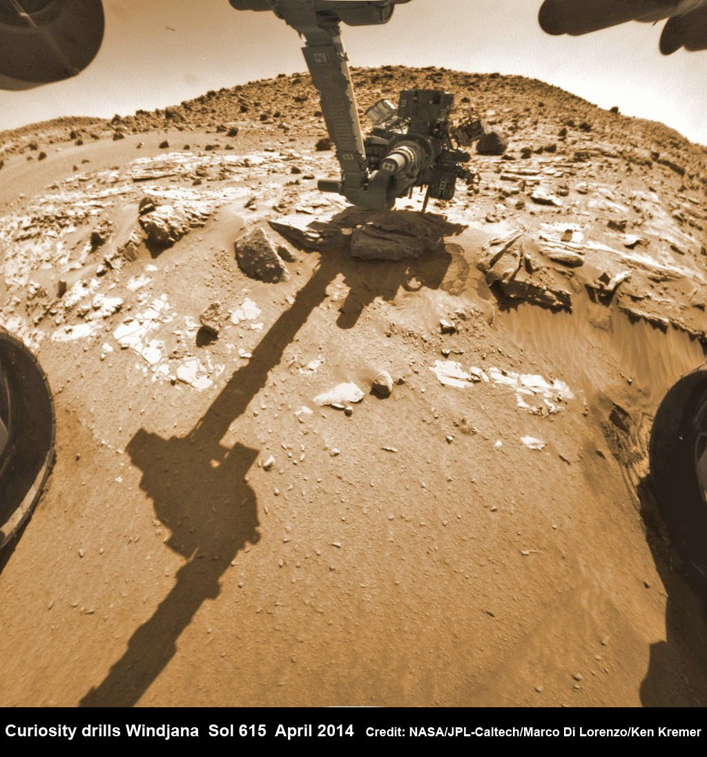
Hazcam fisheye camera image shows Curiosity drilling into “Windjana” rock target on April 29, 2014 (Sol 615). Flattened and colorized image shows Mount Remarkable butte backdrop. Credit: NASA/JPL/Marco Di Lorenzo/Ken Kremer – kenkremer.com
Engineers commanded Curiosity to perform the so called “mini-drill” operation at “Windjana”- as the site of the robots third drilling operation since touching down on the Red Planet back in August 2012.
The 1 ton robot drilled a test hole 0.63 inch (1.6 centimeters) in diameter and to a depth of about 0.8 inch (2 centimeters) using the hammering drill at the terminus of the robotic arm.
Windjana is an outcrop of sandstone located at the base of a Martian butte named Mount Remarkable at “The “Kimberley” waypoint – a science stopping point reached by the rover in early April 2014 along its epic trek to towering Mount Sharp, the primary destination of the mission.
See our photo mosaics illustrating Curiosity’s science activities and drilling operations on “Windjana” and roving around the “Mount Remarkable” butte at “The Kimberley Waypoint” – above and below – by the image processing team of Marco Di Lorenzo and Ken Kremer.
Multisol composite photo mosaic shows deployment of Curiosity’s rovers robotic arm and APXS X-ray spectrometer onto the ‘Winjana’ rock target at Mount Remarkable for evaluation as missions third drill target inside Gale Crater on Mars. The colorized navcam raw images were stitched together from several Martian days up to Sol 612, April 26, 2014. Credit: NASA/JPL-Caltech/Ken Kremer – kenkremer.com/Marco Di Lorenzo
The team is evaluating the resulting hole and powdery, gray colored tailings with the arm’s high resolution MAHLI camera and other instruments to determine whether to follow up with a deep drilling operation to a depth of 2.5 inches (6.4 centimeters).
To prepare for the “mini drill” operation, Curiosity first brushed the candidate drill site off with the wire-bristle Dust Removal Tool (DRT) this past weekend, to clear away obscuring Red Planet dirt and dust hindering observations with the cameras and spectrometers.
“In the brushed spot, we can see that the rock is fine-grained, its true color is much grayer than the surface dust, and some portions of the rock are harder than others, creating the interesting bumpy textures,” said Curiosity science team member Melissa Rice of the California Institute of Technology, Pasadena., in a NASA statement
“All of these traits reinforce our interest in drilling here in order understand the chemistry of the fluids that bound these grains together to form the rock.”
“Windjana,” is named after a gorge in Western Australia.
Curiosity’s Panoramic view of Mount Remarkable at ‘The Kimberley Waypoint’ where rover will conduct 3rd drilling campaign inside Gale Crater on Mars. The navcam raw images were taken on Sol 603, April 17, 2014, stitched and colorized. Credit: NASA/JPL-Caltech/Ken Kremer – kenkremer.com/Marco Di Lorenzo
Why was Kimberley chosen as a science destination ?
“The Kimberley” has interesting, complex stratigraphy,” Curiosity Principal Investigator John Grotzinger, of the California Institute of Technology, Pasadena, told me.
If the team decides that Windjana meets the required criteria, Curiosity will bore a full depth hole into the sandstone rock, and then pulverize and filter it prior to delivery to the two onboard miniaturized chemistry labs – SAM and CheMin.
Windjana would be the first sandstone drill target, if selected. The first two drill locations at ‘John Klein’ and ‘Cumberland’ inside Yellowknife Bay were mudstone.
Curiosity departed the ancient lakebed at the Yellowknife Bay region in July 2013 where she discovered a habitable zone with the key chemical elements and a chemical energy source that could have supported microbial life billions of years ago – and thereby accomplished the primary goal of the mission. Curiosity scans scientifically intriguing rock outcrops of gorgeous Martian terrain at ‘The Kimberley’ waypoint in search of next drilling location beside Mount Remarkable butte, at right. Mastcam color photo mosaic assembled from raw images snapped on Sol 590, April 4, 2014. Credit: NASA/JPL/MSSS/Marco Di Lorenzo/Ken Kremer – kenkremer.com
Stay tuned here for Ken’s continuing Curiosity, Opportunity, Chang’e-3, SpaceX, Orbital Sciences, LADEE, MAVEN, MOM, Mars and more planetary and human spaceflight news.
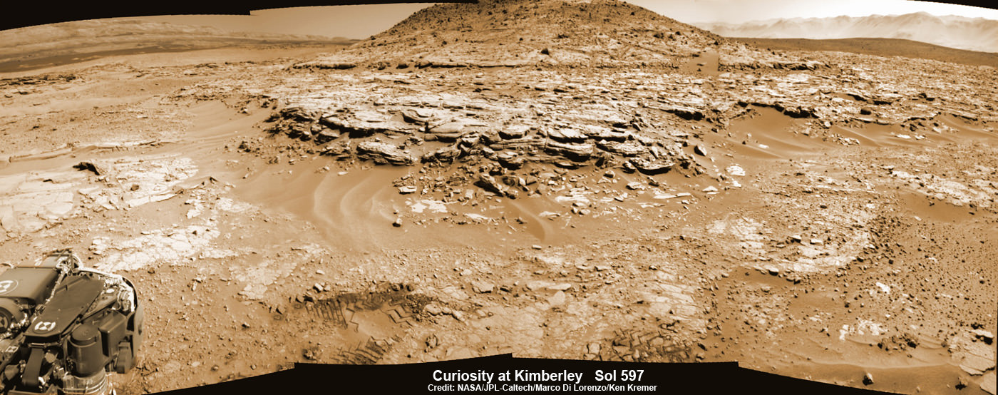
Ken Kremer Curiosity Mars rover captured this panoramic view of a butte called “Mount Remarkable” and surrounding outcrops at “The Kimberley ” waypoint on April 11, 2014, Sol 597. Colorized navcam photomosaic was stitched by Marco Di Lorenzo and Ken Kremer. Credit: NASA/JPL-Caltech/Marco Di Lorenzo/Ken Kremer – kenkremer.com