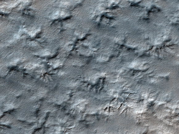
Possible future landing site on Mars. Credit: NASA/JPL/University of Arizona
[/caption]
The HiRISE science team is now taking requests! A new web tool called HiWish is now available for the high-resolution camera on the Mars Reconnaissance Orbiter which allows the public to suggest a location on Mars where the HiRISE instrument should take an image. If you don’t have a particular location, you can use the HiWish site to browse around the planet, examine the locations of other data sets, and find a place that should be imaged. The team will then put into their targeting database, and your suggestion may get selected as an upcoming observation. Furthermore, the HiWish site allows you to track your suggestions and be notified when one of your suggestions gets taken.
Maybe you could even find a really unusual feature on Mars, such as this race-track-like feature that may one day be a landing site for a future mission to the Red Planet. HiRISE images will help determine if this spot is sufficiently safe for landing, such as not too many boulders, steep slopes, or too many high speed MASCAR races — (that’s the Mars Association for Super Cool Aerodynamical Racing). If it is safe, it may be considered for the 2011 Mars Science Laboratory or the 2018 rovers that ESA and NASA are working on for a join mission.
The above image is actually a huge shield volcano in the northeast part of Syrtis Major, and near the Northwest rim of Isidis Planitia, a giant impact basin.
So, go create an account at HiWish and get wishing!
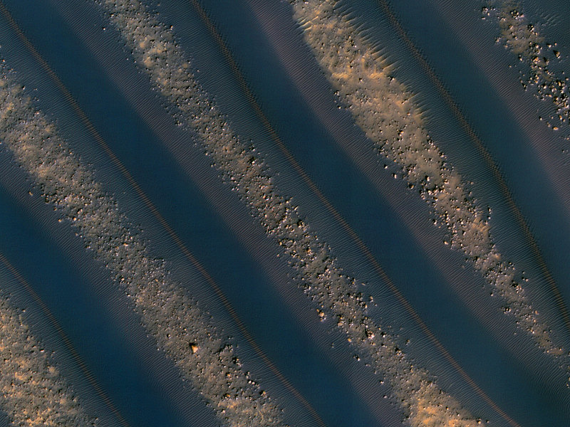
Caption: Dune symmetry on Mars. Credit: NASA/JPL/University of Arizona
It is so wonderful to see the Mars Reconnaissance Orbiter back in action, especially our favorite camera, the High-Resolution Imaging Science Experiment, or HiRISE. The HiRISE team released some of their latest images this week, and they are particularly stunning, including this one of symmetrical dunes in a small crater in Noachis Terra, west of the giant Hellas impact basin. Alfred McEwan, from the HiRISE team and the University of Arizona says the dunes here are linear, and are thought to be created due to shifting wind directions. In places, each dune is remarkably similar to adjacent dunes. The linear dune fields on Mars are similar to the ones seen on Titan, although not quite as large. The debris between the dunes are large boulders.
More images below, but on another note, HiRISE Twitter notes there will be a “big announcement” on Wednesday, January 20. A major discovery? Mission extension? Website redesign? Stay tuned.
This jaw-dropping beauty accompanied a press release announcing that 21 articles from HiRISE made up the entire contents of a special January issue of the journal Icarus . The papers analyzed Martian landforms shaped by winds, water, lava flow, seasonal icing and more.
This view shows color variations in bright layered deposits on a plateau near Juventae Chasma in the Valles Marineris region of Mars.
Contortions on the floor of Hellas Basin. Credit: NASA/JPL/University of Arizona
This almost looks like etchings on Mars’ surface, and they are very strange landforms indeed. McEwan notes that materials appear to have flowed in a viscous manner, like ice, here on the floor of Hellas Basin. Viscous flow features are common over the middle latitudes of Mars, but those in Hellas are especially unique, for unknown reasons.
Frost covered dunes. Credit: NASA/JPL/University of Arizona
This is a beautiful shot of frost covered dunes inside a crater. The HiRISE team says that on the floor of this crater where there are no dunes, the ice forms an uninterrupted layer. On the dunes however, dark streaks form as surface material from below the ice is mobilized and deposited on top of the ice. In some cases this mobile material probably slides down the steep face of the dune, while in other cases it may be literally blown out in a process of gas release similar to removing a cork from a champagne bottle.
Recent impact crater. Credit: NASA/JPL/University of Arizona
This impact crater could be relatively new, as it does not appear in images taken by the Viking Orbiters in 1976. McEwan said the HiRISE team suspects that the crater is more than several decades old, however, “because at full resolution we see a textured surface that is common in dust-mantled regions of Mars, but absent in the youngest craters.” While it could have been created recently, the other explanation is that there may have been more dust on the surface in 1976 or the air may have been hazy, obscuring the crater.
Click on each of the images for access to the higher resolution versions, or go directly to the HiRISE website.
Caption: The Phoenix Mars Lander, its backshell and its heatshield are visible within this enhanced-color image of the Phoenix landing site taken on Jan. 6, 2010 by the High Resolution Imaging Science Experiment (HiRISE) camera on NASA’s Mars Reconnaissance Orbiter. Image credit: NASA/JPL-Caltech/University of Arizona
Listen up, all you Phoenix lander fans! Beginning Jan. 18, the Mars Odyssey orbiter will start listening for any signs of life from Phoenix, which has been sitting silently on the frozen arctic region of Mars since its last communication in November 2008. The Phoenix team says hearing any radio transmission from the lander is high improbably, but possible. Never say never….
“We do not expect Phoenix to have survived, and therefore do not expect to hear from it. However, if Phoenix is transmitting, Odyssey will hear it,” said Chad Edwards, chief telecommunications engineer for the Mars Exploration Program at NASA’s Jet Propulsion Laboratory, Pasadena, Calif. “We will perform a sufficient number of Odyssey contact attempts that if we don’t detect a transmission from Phoenix, we can have a high degree of confidence that the lander is not active.”
Odyssey will pass over the Phoenix landing site approximately 10 times each day during three consecutive days of listening this month and two longer listening campaigns in February and March. The listening attempts will continue until after the sun is above the horizon for the full 24.7 hours of the Martian day at the lander’s high-latitude site. During the later attempts in February or March, Odyssey will transmit radio signals that could potentially be heard by Phoenix, as well as passively listening. Phoenix close up from July 2009. Annotated by Phil Stooke.
In the extremely unlikely case that Phoenix survived the winter, it is expected to follow instructions programmed on its computer. If systems still operate, once its solar panels generate enough electricity to establish a positive energy balance, the lander would periodically try to communicate with any available Mars relay orbiters in an attempt to reestablish contact with Earth. During each communications attempt, the lander would alternately use each of its two radios and each of its two antennas.
If Odyssey does hear from Phoenix, the orbiter will attempt to lock onto the signal and gain information about the lander’s status. The initial task would be to determine what capabilities Phoenix retains, information that NASA would consider in decisions about any further steps.
Phoenix landed in May, 2008 and worked for about five months before succumbing to the cold weather. Since then, Phoenix’s landing site has gone through autumn, winter and part of spring. The lander’s hardware was not designed to survive the temperature extremes and ice-coating load of an arctic Martian winter.
But who knows; our Mars spacecraft seemingly have a tendency to surprise us…
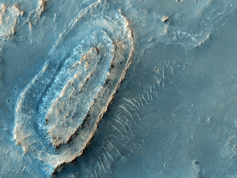
Could the Mars Polar Lander's remains be hidden somewhere in this HiRISE image?
[/caption]
Finding hidden treasure would be a great way to start the new year, don’t you think? And somewhere in this patterned landscape the remains of a missing spacecraft could be hidden, just waiting to be found. The Mars Polar Lander arrived at the Red Planet 10 years ago in December of 1999, but just before the lander entered the Martian atmosphere, MPL went silent. An immediate search began for the remains of the MPL using images from Mars Global Surveyor, and now the HiRISE camera on the Mars Reconnaissance Orbiter is continuing the search with high resolution images of the area in which MPL is most likely to have landed. The image here is another image in a series of images from HiRISE to look for MPL.
Investigations propose the most likely cause of the mission failure is that the spacecraft’s computers misinterpreted the release of the lander’s legs in preparation for descent as touch-down on the Martian surface, causing descent engines to shut off when the lander was still 40 meters (130 feet) above ground. However, no one knows for sure.
Find higher resolution images of this region here. See our previous articles about finding MPL — with additional images — here, and here.
See this page from the HiRISE site for a links to all the images. On this page, you’ll find an overview of the Mars Polar Lander, its disappearance, the search to find it, and why they want to find it. Emily also has a lengthy post with tips and instructions on how to search for particular objects in the HiRISE images. If you think you have found something of interest, post a comment on this page of the HiRISE Blog, or use this form to contact the HiRISE team. The UnmannedSpaceflight website has a thread discussing the search (serious searchers only).
Will Spirit have a happy 2010? Let's hope so! Image created by Stu Atkinson.
In just a few days, the Spirit rover will celebrate six incredible years on Mars. But JPL put out a press release today, as well as the video above, saying the outlook for Spirit’s survival is not good. Being stuck in a sand trap with wheels that aren’t working well are challenges to Spirit’s mobility that could prevent the rover team from using a key survival strategy — positioning the rover’s solar panels to tilt toward the sun to collect power for heat to survive the severe Martian winter. “The highest priority for this mission right now is to stay mobile, if that’s possible,” said Steve Squyres, principal investigator for the rovers.
I’m still holding out hope, however, that the rover team will work another miracle, and that 2010 will be another happy year for Spirit on Mars — see the image below created by Stu Atkinson.
[/caption]
But if mobility is not possible, the next priority is survival. To to that, the rover team will attempt to improve the rover’s tilt, while Spirit is able to generate enough electricity to turn its wheels. Spirit is in the southern hemisphere of Mars, where it is autumn, and the amount of daily sunshine available for the solar-powered rover is declining. This could result in ceasing extraction activities as early as January, depending on the amount of remaining power. Spirit’s tilt, nearly five degrees toward the south, is unfavorable because the winter sun crosses low in the northern sky.
Unless the tilt can be improved or luck with winds affects the gradual buildup of dust on the solar panels, the amount of sunshine available will continue to decline until May 2010. During May, or perhaps earlier, Spirit may not have enough power to remain in operation.
“At the current rate of dust accumulation, solar arrays at zero tilt would provide barely enough energy to run the survival heaters through the Mars winter solstice,” said Jennifer Herman, a rover power engineer at NASA’s Jet Propulsion Laboratory in Pasadena, Calif.
The team is evaluating strategies for improving the tilt even if Spirit cannot escape the sand trap, such as trying to dig in deeper with the wheels on the north side. In February, NASA will assess Mars missions, including Spirit, for their potential science versus costs to determine how to distribute limited resources. Meanwhile, the team is planning additional research about what a stationary Spirit could accomplish as power wanes.
“Spirit could continue significant research right where it is,” said Ray Arvidson of Washington University in St. Louis, deputy principal investigator for the rovers. “We can study the interior of Mars, monitor the weather and continue examining the interesting deposits uncovered by Spirit’s wheels.”
A study of the planet’s interior would use radio transmissions to measure wobble of the planet’s axis of rotation, which is not feasible with a mobile rover. That experiment and others might provide more and different findings from a mission that has already far exceeded expectations.
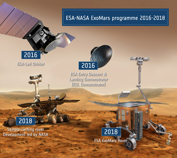
Elements of the ESA-NASA ExoMars program 2016-2018. Credit: ESA
[/caption]
The new joint Mars exploration program of NASA and ESA is quickly pushing forward to implement an agreed upon framework to construct an ambitious new generation of red planet orbiters and landers starting with the 2016 and 2018 launch windows.
The European-led ExoMars Trace Gas Mission Orbiter (TGM) has been selected as the first spacecraft of the joint initiative and is set to launch in January 2016 aboard a NASA supplied Atlas 5 rocket for a 9 month cruise to Mars. The purpose is to study trace gases in the martian atmosphere, in particular the sources and concentration of methane which has significant biological implications. Variable amounts of methane have been detected by a martian orbiter and ground based telescopes on earth. The orbiter will likely be accompanied by a small static lander provided by ESA and dubbed the Entry, Descent and Landing Demonstrator Module (EDM).
The NASA Mars Program is shifting its science strategy to coincide with the new joint venture with ESA and also to build upon recent discoveries from the current international fleet of martian orbiters and surface explorers Spirit, Opportunity and Phoenix (see my earlier mars mosaics). Doug McCuiston, NASA’s director of Mars Exploration at NASA HQ told me in an interview that, “NASA is progressing quickly from ‘Follow the Water’ through assessing habitability and on to a theme of ‘Seeking the Signs of Life’. Looking directly for life is probably a needle in the haystack, but the signatures of past or present life may be more wide spread through organics, methane sources, etc”.
NASA and ESA will issue an “Announcement of Opportunity for the orbiter in January 2010” soliciting proposals for a suite of science instruments according to McCuiston. “The science instruments will be competitively selected. They are open to participation by US scientists who can also serve as the Principal Investigators (PI’s)”. Proposals are due in 3 months and will be jointly evaluated by NASA and ESA. Instrument selections are targeted for announcement in July 2010 and the entire cost of the NASA funded instruments is cost capped at $100 million.
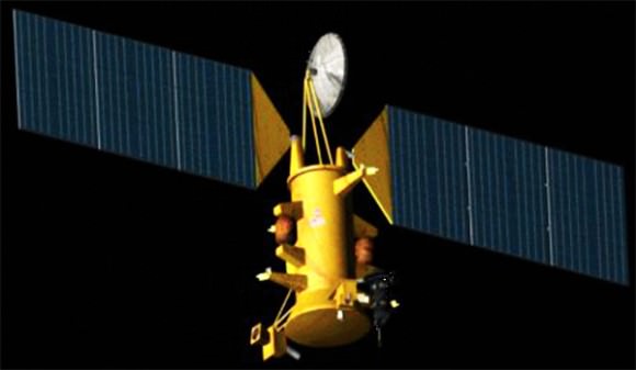
Mars Trace Gas Mission orbiter slated for 2016 launch is the first spacecraft in the new ESA & NASA Mars Exploration Joint Initiative. Credit: NASA ESA
“The 2016 mission must still be formally approved by NASA after a Preliminary Design Review, which will occur either in late 2010 or early 2011. Funding until then is covered in the Mars Program’s Next Decade wedge, where all new-start missions reside until approved, or not, by the Agency”, McCuiston told me. ESA’s Council of Ministers just gave the “green light” and formally approved an initial budget of 850 million euros ($1.2 Billion) to start implementing their ExoMars program for the 2016 and 2018 missions on 17 December at ESA Headquarters in Paris, France. Another 150 million euros will be requested within two years to complete the funding requirement for both missions.
ESA has had to repeatedly delay its own ExoMars spacecraft program since it was announced several years ago due to growing complexity, insufficient budgets and technical challenges resulting in a de-scoping of the science objectives and a reduction in weight of the landed science payload. The ExoMars rover was originally scheduled to launch in 2009 and is now set for 2018 as part of the new architecture.
The Trace Gas orbiter combines elements of ESA’s earlier proposed ExoMars orbiter and NASA’s proposed Mars Science Orbiter. As currently envisioned the spacecraft will have a mass of about 1100 kg and carry a roughly 115 kg science payload, the minimum deemed necessary to accomplish its goals. The instruments must be highly sensitive in order to be capable of detecting the identity and extremely low concentration of atmospheric trace gases, characterizing the spatial and temporal variation of methane and other important species, locating the source origin of the trace gases and determining if they are caused by biologic or geologic processes. Current photochemical models cannot explain the presence of methane in the martain atmosphere nor its rapid appearance and destruction in space, time or quantity.
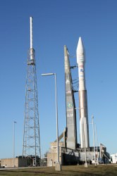
An Atlas rocket similar to this vehicle I observed at Cape Canaveral Pad 41 is projected to launch the 2016 Mars orbiter. Credit: Ken Kremer
Among the instruments planned are a trace gas detector and mapper, a thermal infrared imager and both a wide angle camera and a high resolution stereo color camera (1 – 2 meter resolution). “All the data will be jointly shared and will comply with NASA’s policies on fully open access and posting into the Planetary Data System”, said McCuiston.
Another key objective of the orbiter will be to establish a data relay capability for all surface missions up to 2022, starting with 2016 lander and two rovers slotted for 2018. This timeframe could potentially coincide with Mars Sample Return missions, a long sought goal of many scientists.
If the budget allows, ESA plans to piggyback a small companion lander (EDM) which would test critical technologies for future missions. McCuiston informed me that, “The objective of this ESA Technology Demonstrator is validating the ability to land moderate payloads, so the landing site selection will not be science-driven. So expect something like Meridiani or Gusev—large, flat and safe. NASA will assist ESA engineering as requested, and within ITAR constraints.” EDM will use parachutes, radar and clusters of pulsing liquid propulsion thrusters to land.
“ESA plans a competitive call for instruments on their 3-4 kg payload”, McCuiston explained. “The Announcement of Opportunity will be open to US proposers as well so there may be some US PI’s. ESA wants a camera to ‘prove’ they got to the ground. Otherwise there is no significant role planned for NASA in the EDM”.
The lander would likely function as a weather station and be relatively short lived, perhaps 8 Sols or martian days, depending on the capacity of the batteries. ESA is not including a long term power source, such as from solar arrays, so the surface science will thus be limited in duration.
The orbiter and lander would separate upon arrival at Mars. The orbiter will use a series of aerobraking maneuvers to eventually settle into a 400 km high circular science orbit inclined at about 74 degrees.
The joint Mars architecture was formally agreed upon last summer at a bilateral meeting between Ed Weiler (NASA) and David Southwood (ESA) in Plymouth, UK. Weiler is NASA’s Associate Administrator for the Science Mission Directorate and Southwood is ESA’s Director of Science and Robotic Exploration. They signed an agreement creating the Mars Exploration Joint Initiative (MEJI) which essentially weds the Mars programs of NASA and ESA and delineates their respective program responsibilities and goals.
“The key to moving forward on Mars exploration is international collaboration with Europe”, Weiler said to me in an interview. “We don’t have enough money to do these missions separately. The easy things have been done and the new ones are more complex and expensive. Cost overruns on Mars Science Lab (MSL) have created budgetary problems for future mars missions”. To pay for the MSL overrun, funds have to be taken from future mars budget allocations from fiscal years 2010 to 2014.
“2016 is a logical starting point to work together. NASA can have a 2016 mission if we work with Europe but not if we work alone. We can do so much more by working together since we both have the same objectives scientifically and want to carry out the same types of mission”. Weiler and Southwood instructed their respective science teams to meet and lay out a realistic and scientifically justifiable approach. Weiler explained to me that his goal and hope was to reinstate an exciting Mars architecture with new spacecraft launching at every opportunity which occurs every 26 months and which advance the state of the art for science. “It’s very important to demonstrate a critical new technology on each succeeding mission”.
More on the 2018 mission plan and beyond in a follow up report.
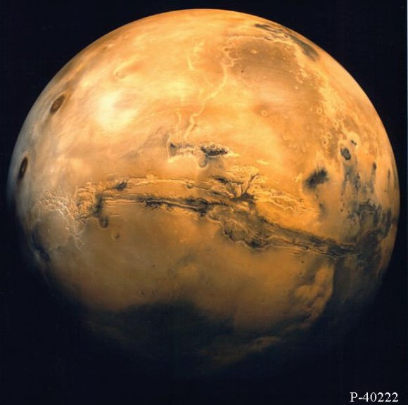
Mars from orbit. Valles Marineris and Volcanic region
Could it be true that the old gimpy wheel on the Spirit rover is making a comeback? The right-front wheel, which stopped operating way back on Sol 779 (March 13, 2006), surprised engineers by indicating normal resistance and turning slightly during a resistance test for that wheel. Spirit, which has been stuck in soft soil for several months, recently got bad news that the right rear wheel also stopped working (Nov. 21), leaving her with just four of six wheels operational. Engineers conducted tests on Dec. 12 and the right rear wheel continued to show no motion and exhibited very high resistance in the motor winding. Just for fun (I’m assuming) engineers also test the right front wheel – the wheel that Spirit has limped with in coming down from the top of Husband Hill and making the trek across Gusev Crater to the Home Plate region where she currently sits. In surprises of all surprises, the old gimpy wheel showed signs of life.
Diagnostic tests were run on Spirit’s right-rear wheel and right-front wheel on Sol 2013 (Dec. 12, 2009). The recently stalled right-rear wheel continued to show no motion. Engineers expected nothing from the right front wheel. The last time it was checked was just after its apparent failure in 2006 and at that time indicated an open circuit. JPL says that although no clear theory for failure had been established, the failure was generally regarded as permanent.
JPL also says it is important to remember that the Sol 2013 test of the right-front wheel was only a rotor resistance test, and no conclusions can be drawn at this point without further testing.
The plan for Spirit on Sol 2116 (Dec. 15) is to command a drive, which will test the functionality of both the right-front and the right-rear wheels. The results are expected Wednesday.
ESA’s Mars Express orbiter took images last month of Mars two moons, Phobos and Deimos. This is the first time the moons have been imaged together in high resolution, but as Emily Lakdawalla points out on Planetary Blog, not the first time the two have been imaged together: the Spirit rover did it back in 2005! But these new image definitely provide a ‘wow’ factor, as well as helping to validate and refine existing orbit models of the two moons.
Phobos and Deimos together for the first time in high resolution. Credits: ESA/DLR/FU Berlin (G. Neukum)
“It doesn’t happen very often that both Martian moons are right in front of the camera, directly one behind the other,” said Harald Hoffmann from the German Aerospace Center (DLR).
“During the now more than six-year long project, we have had several opportunities to photograph the two moons together,” said Klaus-Dieter Matz, who worked with Hoffmann to plan the acquisition of these images. “The geometry of the constellation during Orbit 7492 on 5 November 2009 was especially favorable, so this time we wanted to try taking a sequence of photographs – and this first attempt has delivered the expected result!”
The geometrical relationships between Mars, its moons and the Mars Express probe at the time of the sequence. Credit: DLR
Phobos, the larger of the two moons, orbits closer to the Red Planet, circling it every 7 hours and 39 minutes. It travels faster relative to Mars than the Moon relative to Earth. It was 11,800 km from Mars Express when the images were taken. Deimos was 26,200 km away.
The images were acquired with the Super Resolution Channel (SRC) of the High Resolution Stereo Camera (HRSC). The camera took 130 images of the moons on 5 November at 9:14 CET over period of 1.5 minutes at intervals of 1s, speeding up to 0.5-s intervals toward the end. The image resolution is 110 m/pixel for Phobos and 240 m/pixel for Deimos — since Deimos was more than twice as far from the camera.
The Mars Global Surveyor was a spacecraft sent to Mars in 1996. It arrived at Mars and studied the planet for 10 years, until it broke down in 2006, and controllers on Earth lost contact with it. But while it was operating, the spacecraft took thousands of images, and made some major discoveries about Mars.
Mars Global Surveyor was launched on November 7, 1996, and made its orbital insertion on September 11, 1997. It used a technique called aerobraking to reduce its orbit and bring it into an orbit that brought it to an average distance of 378 km from the surface of Mars. It circled the planet in a polar orbit once every 117 minutes, which allowed it to photograph the entire Martian surface.
The spacecraft was equipped with 5 major scientific instruments: Mars Orbiter Camera, Mars Orbiter Laser Altimeter, Thermal Emission Spectrometer, Magnetometer and electron reflectometer and the Ultrastable Oscillator for Doppler measurements. These instruments allowed the spacecraft to study the atmosphere and surface composition of Mars. But it also sent back the highest resolution photographs ever seen of Mars. The newer Mars Reconnaissance Orbiter has returned better images with its larger telescope, but when the first MGS images first came back from Mars, they were stunning.
It made some incredible discoveries about Mars. Thanks to the observations from MGS, astronomers determined that Mars had a layered crust that was more than 10 km thick. It found ancient craters that had been buried and then later exposed by erosion, and it found evidence of ancient lava flows.
But perhaps the biggest discovery was made in 2006, which researchers announced that they had uncovered evidence of recent water activity on Mars. Images from the Mars Global Surveyor showed gullies on Mars which looked like they’d been formed by water. It’s possible that water had erupted out of an underground aquifer and spilled down the slope of a hill before evaporating in the pressure of the Martian atmosphere.
After a decade of service, Mars Global Surveyor went silent on November 2, 2006. It went into safe mode after being issued commands to change the orientation of its solar panels, and it stopped communicating. NASA said that it was, “battery failure caused by a complex sequence of events involving the onboard computer memory and ground commands.” But we’ll never really know what happened to it.
[/caption]Planet Mars’ Olympus Mons holds the record for the tallest known peak in the entire Solar System. Having a height three times taller than Mount Everest’s and a base wide enough to prevent an observer at the base from seeing the top, you would have expected Mars to be on a relatively big planet. But did you know that Mars is much smaller than Earth? So how big is Mars?
The radius of Mars is only about half that of the Earth’s radius; roughly 3,396 km at the equator and 3,376 km at the poles. For comparison, the earth’s equatorial radius is 6,378 km, while its polar radius is 6,357 km.
These radii give Mars a surface area roughly only 28.4% of Earth’s or 144,798,500 km2. The Pacific Ocean is even larger, with an area of roughly 169,200,000 km2.
The dimensions of Mars also gives it a volume approximately equal to 1.6318×10¹¹ km2 and a mass approximately equal to 6.4185×10²³ kg. That’s only about 15.1% and 10.7% that of the Earth’s, respectively.
Despite its noticeably smaller size than the Earth, Mars has more majestic geographical features.
For instance, there’s Valles Marineris, a 4,000 km-long and 7 km-deep canyon that spans about one-fifth of the entire planet’s circumference. It is so long that it’s even longer than the length of Europe. If you compare the Grand Canyon to it, Colorado’s pride and joy won’t look so grand anymore.
Want to know how long the Grand Canyon is? 446 km. That’s very long, yes. But that’s only a little over 10% the length of Valles Marineris.
That’s not the only large geographical feature on Mars. Ma’adim Vallis, is another canyon on Mars that’s larger then the Grand Canyon, with a length of 700 km. Then there’s an impact crater that’s been found to be larger than the combined surface area of the continents of Asia, Europe, and Australia.
Now that you know about these extremely majestic geographical features on Mars, the next time someone asks you, “How big is Mars?” you can tell them how it is much smaller than the Earth … but you can also add the salient features that make the Red Planet much more interesting when it comes to a discussion on sizes.


 to extricate itself from the sand trap known as \"Troy,\" but stopped earlier than expected because of excessive sinkage. Image Credit: NASA/JPL-Caltech")

")