Soviet Lander Spotted by Mars Orbiter

The bright spot in the center of this HiRISE image may be the 11-meter-wide parachute from Mars 3's descent stage (NASA/JPL-Caltech/Univ. of Arizona)

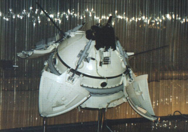
On May 28, 1971, the Soviet Union launched the Mars 3 mission which, like its previously-launched and ill-fated sibling Mars 2, consisted of an orbiter and lander destined for the Red Planet. Just over six months later on December 2, 1971, Mars 3 arrived at Mars — five days after Mars 2 crashed. The Mars 3 descent module separated from the orbiter and several hours later entered the Martian atmosphere, descending to the surface via a series of parachutes and retrorockets. (Sound familiar?) Once safely on the surface, the Mars 3 lander opened its four petal-shaped covers to release the 4.5-kg PROP-M rover contained inside… and after 20 seconds of transmission, fell silent. Due to unknown causes, the Mars 3 lander was never heard from or seen again.

Until now.

These images show what might be hardware from the Soviet Union's 1971 Mars 3 lander ( NASA/JPL-Caltech/Univ. of Arizona)
These images show what might be hardware from the Soviet Union’s 1971 Mars 3 lander (NASA/JPL-Caltech/Univ. of Arizona)

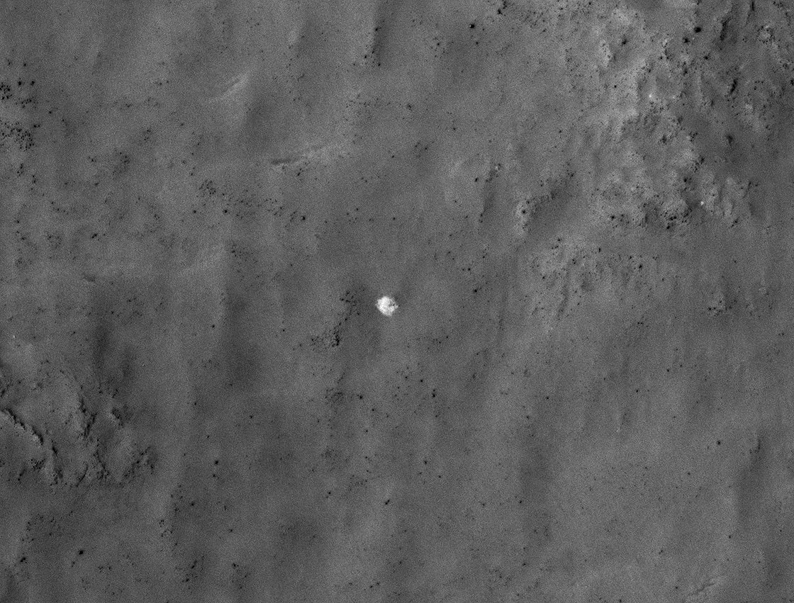
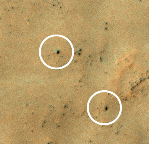
The set of images above shows what might be hardware from the 1971 Soviet Mars 3 lander, seen in a pair of images from the High Resolution Imaging Science Experiment (HiRISE) camera on NASA’s Mars Reconnaissance Orbiter.

While following news about Mars and NASA’s Curiosity rover, Russian citizen enthusiasts found four features in a five-year-old image from Mars Reconnaissance Orbiter that resemble four pieces of hardware from the Mars 3 mission: the parachute, heat shield, terminal retrorocket and lander. A follow-up image by the orbiter from last month shows the same features.

“Together, this set of features and their layout on the ground provide a remarkable match to what is expected from the Mars 3 landing, but alternative explanations for the features cannot be ruled out.”

– Alfred McEwen, HiRISE Principal Investigator

The Mars 3 lander (NSSDC)

Vitali Egorov from St. Petersburg, Russia, heads the largest Russian Internet community about Curiosity. His subscribers did the preliminary search for Mars 3 via crowdsourcing. Egorov modeled what Mars 3 hardware pieces should look like in a HiRISE image, and the group carefully searched the many small features in this large image, finding what appear to be viable candidates in the southern part of the scene. Each candidate has a size and shape consistent with the expected hardware, and they are arranged on the surface as expected from the entry, descent and landing sequence.

“I wanted to attract people’s attention to the fact that Mars exploration today is available to practically anyone,” Egorov said. “At the same time we were able to connect with the history of our country, which we were reminded of after many years through the images from the Mars Reconnaissance Orbiter.”

The predicted Mars 3 landing site was at latitude 45 degrees south, longitude 202 degrees east, in Ptolemaeus Crater. HiRISE acquired a large image at this location in November 2007, and promising candidates for the hardware from Mars 3 were found on Dec. 31, 2012.

Candidate features of the Mars 3 retrorockets (top) and lander (bottom)

The candidate parachute is the most distinctive feature in the images (seen above at top.) It is an especially bright spot for this region, about 8.2 yards (7.5 meters) in diameter.

The parachute would have a diameter of 12 yards (11 meters) if fully spread out over the surface, so this is consistent.

“Together, this set of features and their layout on the ground provide a remarkable match to what is expected from the Mars 3 landing, but alternative explanations for the features cannot be ruled out,” said HiRISE Principal Investigator Alfred McEwen of the University of Arizona, Tucson. “Further analysis of the data and future images to better understand the three-dimensional shapes may help to confirm this interpretation.”

Source: NASA/JPL


More Evidence That Mars Lost Its Atmosphere

Mosaic self-portrait of Curiosity at the John Klein outcrop on Feb. 3, 2013 (NASA/JPL-Caltech/MSSS)

Although today Mars’ atmosphere is sparse and thin — barely 1% the density of Earth’s at sea level — scientists don’t believe that was always the case. The Red Planet likely had a much denser atmosphere similar to ours, long, long ago. So… what happened to it?

NASA’s Curiosity rover has now found strong evidence that Mars lost much of its atmosphere to space — just as many scientists have suspected. The findings were announced today at the EGU 2013 General Assembly in Vienna.

Curiosity's SAM instrument (NASA/JPL-Caltech)
Curiosity’s SAM instrument (NASA/JPL-Caltech)

Curiosity’s microwave oven-sized Sample Analysis at Mars (SAM) instrument analyzed an atmosphere sample last week using a process that concentrates selected gases. The results provided the most precise measurements ever made of isotopes of argon in the Martian atmosphere.

Isotopes are variants of the same element with different atomic weights.

“We found arguably the clearest and most robust signature of atmospheric loss on Mars,” said Sushil Atreya, a SAM co-investigator at the University of Michigan.

SAM found that the Martian atmosphere has about four times as much of a lighter stable isotope (argon-36) compared to a heavier one (argon-38). This ratio is much lower than the Solar System’s original ratio, as estimated from measurements of the Sun and Jupiter.

The argon isotope fractionation provides clear evidence of the loss of atmosphere from Mars. (NASA/JPL)

This also removes previous uncertainty about the ratio in the Martian atmosphere in measurements from NASA’s Viking project in 1976, as well as from small volumes of argon extracted from Martian meteorites retrieved here on Earth.

These findings point to a process that favored loss of the lighter isotope over the heavier one, likely through gas escaping from the top of the atmosphere. This appears to be in line with a previously-suggested process called sputtering, by which atoms are knocked out of the upper atmosphere by energetic particles in the solar wind.

The solar wind may have helped strip Mars of its atmosphere over the course of many hundreds of millions of years (NASA)

Lacking a strong magnetic field, Mars’ atmosphere would have been extremely susceptible to atmospheric erosion by sputtering billions of years ago, when the solar wind was an estimated 300 times the density it is today.

These findings by Curiosity and SAM will undoubtedly support those made by NASA’s upcoming MAVEN mission, which will determine how much of the Martian atmosphere has been lost over time by measuring the current rate of escape to space. Scheduled to launch in November, MAVEN will be the first mission devoted to understanding Mars’ upper atmosphere.

Find out more about MAVEN and how Mars may have lost its atmosphere in the video below, and follow the most recent discoveries of the MSL mission here.

Source: NASA/JPL

Terran Fleet at Mars Takes a Break for Conjunction – Enjoy the Video and Parting View

Curiosity and Mount Sharp - Parting Shot ahead of Solar Conjunction. Enjoy this parting view of Curiosity's elevated robotic arm and drill are staring at you - back dropped with her ultimate destination - Mount Sharp - in this panoramic vista of Yellowknife Bay basin snapped on March 23, Sol 223, by the rover's navigation camera system. The raw images were stitched by Marco Di Lorenzo and Ken Kremer and colorized. Credit: NASA/JPL-Caltech/Marco Di Lorenzo/KenKremer (kenkremer.com). See video below explaining Mars Solar Conjunction

Curiosity and Mount Sharp – Parting Shot ahead of Mars Solar Conjunction
Enjoy this parting view of Curiosity’s elevated robotic arm and drill staring at you; back dropped with her ultimate destination – Mount Sharp – in this panoramic vista of Yellowknife Bay basin snapped on March 23, Sol 223, by the rover’s navigation camera system. The raw images were stitched by Marco Di Lorenzo and Ken Kremer and colorized. Credit: NASA/JPL-Caltech/Marco Di Lorenzo/KenKremer (kenkremer.com)
See video below explaining Mars Solar Conjunction[/caption]

Earth’s science invasion fleet at Mars is taking a break from speaking with their handlers back on Earth.

Why ? Because as happens every 26 months, the sun has gotten directly in the way of Mars and Earth.

Earth, Mars and the Sun are lined up in nearly a straight line. The geometry is normal and it’s called ‘Mars Solar Conjunction’.

Conjunction officially started on April 4 and lasts until around May 1.

From our perspective here on Earth, Mars will be passing behind the Sun.

Watch this brief NASA JPL video for an explanation of Mars Solar Conjunction.

Therefore the Terran fleet will be on its own for the next month since the sun will be blocking nearly all communications.

In fact since the sun can disrupt and garble communications, mission controllers will be pretty much suspending transmissions and commands so as not to inadvertently create serious problems that could damage the fleet in a worst case scenario.

Right now there are a trio of orbiters and a duo of rovers from NASA and ESA exploring Mars.

The spacecraft include the Curiosity (MSL) and Opportunity (MER) rovers from NASA. Also the Mars Express orbiter from ESA and the Mars Odyssey (MO) and Mars Reconnaissance Orbiter (MRO) from NASA.

Geometry of Mars Solar Conjunction

Because several of these robotic assets have been at Mars for nearly 10 years and longer, the engineering teams have a lot of experience with handling them during the month long conjunction period.

“This is our sixth conjunction for Odyssey,” said Chris Potts of JPL, mission manager for NASA’s Mars Odyssey, which has been orbiting Mars since 2001. “We have plenty of useful experience dealing with them, though each conjunction is a little different.”

But there is something new this go round.

“The biggest difference for this 2013 conjunction is having Curiosity on Mars,” Potts said. Odyssey and the Mars Reconnaissance Orbiter relay almost all data coming from Curiosity and the Mars Exploration Rover Opportunity, as well as conducting the orbiters’ own science observations.

The rovers and orbiters can continue working and collecting science images and spectral data.

But that data will all be stored in the on board memory for a post-conjunction playback starting sometime in May.

Ken Kremer

…………….

Learn more about Curiosity’s groundbreaking discoveries and NASA missions at Ken’s upcoming lecture presentations:

April 20/21 : “Curiosity and the Search for Life on Mars – (in 3-D)”. Plus Orion, SpaceX, Antares, the Space Shuttle and more! NEAF Astronomy Forum, Suffern, NY

April 28: “Curiosity and the Search for Life on Mars – (in 3-D)”. Plus the Space Shuttle, SpaceX, Antares, Orion and more. Washington Crossing State Park, Titusville, NJ, 130 PM

MAVEN’s Magnetometer Will Look Back in Time

Artist depiction of the MAVEN spacecraft. Credit: NASA

The next mission to the Red Planet, the Mars Atmosphere and Volatile Evolution (MAVEN) will be the first spacecraft ever to make direct measurements of the Martian atmosphere. MAVEN will carry eight science instruments, including a magnetometer that will investigate what remains of Mars’ magnetic “shield,” and will, in essence, help to look back in time at what may have happened to a planet once thought to have an abundance of liquid water but is now a frozen desert. The magnetometer will play a key role in studying the planet’s atmosphere and interactions with solar wind, helping answer the question of why Mars lost much of its atmosphere.

“The magnetometer helps us see where the atmosphere is protected by mini-magnetospheres and where it’s open to solar wind,” said Jack Connerney, a co-investigator for the mission. “We can study the solar wind impact and how efficient it is at stripping the atmosphere.”


By measuring sections of the planet’s magnetic field, the magnetometer could help scientists create a bigger picture of the planet’s overall atmosphere.

MAVEN is the first mission to Mars specifically designed to help scientists understand the past – and also the ongoing — escape of CO2 and other gases into space. MAVEN will orbit Mars for at least one Earth-year, about a half of a Martian year. MAVEN will provide information on how and how fast atmospheric gases are being lost to space today, and infer from those detailed studies what happened in the past.

Studying how the Martian atmosphere was lost to space can reveal clues about the impact that change had on the Martian climate, geologic, and geochemical conditions over time, all of which are important in understanding whether Mars had an environment able to support life.

MAVEN is scheduled to launch in 2013, with a launch window from Nov. 18 to Dec 7, 2013. Mars Orbit Insertion will be in mid-September2014.

Find out more about MAVEN at the mission website.

NASA Scientists Discuss Potential Comet Impact on Mars

The orbit diagram for Comet 2013 A1 as it will approach Mars in October, 2014.

There is a small but non-negligible chance that Comet 2013 A1 will hit Mars October of 2014. According the latest calculations from JPL, the comet is estimated to come within 120,000 kilometers (74,000 miles). In this video, various NASA scientists discuss the potential impact, and invariably view such an impact as scientifically very intriguing.

“I think of it as a giant climate experiment,” said Michael Meyer, lead scientist for the Mars Exploration Program. “An impact would loft a lot of stuff into the Martian atmosphere–dust, sand, water and other debris. The result could be a warmer, wetter Mars than we’re accustomed to today.”

An impact would likely have consequences for the current rovers on Mars. Meyer said the solar-powered Opportunity might have a hard time surviving if the atmosphere became opaque. Nuclear-powered Curiosity, though, would carry on just fine. He also notes that Mars orbiters might have trouble seeing the surface, for a while at least, until the debris begins to clear.

The trajectory for comet Siding Spring is being refined as more observations are made. Rob McNaught discovered this comet on Jan. 3, 2013, at Siding Spring Observatory in Australia, and looking back at archival observations has unearthed more images of the comet, extending the observation interval back to Oct. 4, 2012. Further refinement to its orbit is expected as more observational data is obtained.

Scientists estimate the nucleus of the comet is about 1 to 3 km in diameter. If it gets close to Mars and is grabbed by its gravity,and IF there was an impact it would be a substantial hit. “If it does hit Mars, it would deliver as much energy as 35 million megatons of TNT,” said Don Yeomans of NASA’s Near-Earth Object Program at JPL. According to what Yeomans says in this video, the current odds of it hitting Mars is about 1 in 2,000, but according to the parameters at JPL’s website, it appears the odds are about 1 in 10,000.

Source: Science@NASA

Curiosity is Back! Snapping Fresh Martian Vistas

Curiosity's raised robotic arm and drill are staring at you in this new panoramic vista of Yellowknife Bay basin snapped on March 23, Sol 223 by the rover's navigation camera system. The raw images were stitched by Marco Di Lorenzo and Ken Kremer and colorized. Credit: NASA/JPL-Caltech/Marco Di Lorenzo/KenKremer (kenkremer.com)

Curiosity is back! After a multi-week hiatus forced by a computer memory glitch, NASA’s mega rover is back to full operation.

And the proof is crystal clear in the beautiful new panoramic view (above) snapped by Curiosity this weekend from Yellowknife Bay, showing the robot’s arm and drill elevated and aiming straight at you – raring to go and ready to feast on something deliciously Martian.

“That drill is hungry, looking for something tasty to eat, and ‘you’ (loaded with water and organics) are it,” I thought with a chuckle as Curiosity seeks additional habitats and ingredients friendly to life.

So my imaging partner Marco Di Lorenzo and I celebrated the great news by quickly creating the new panoramic mosaic assembled from images taken on Saturday, March 23, or Sol 223, by the robot’s navigation cameras. Our new Curiosity mosaic was first featured on Saturday at NBC News Cosmic Log by Alan Boyle – while I was hunting for Comet Pan-STARRS.

So the fact that Curiosity is again snapping images and transmitting fresh alien vistas and new science data is a relief to eagerly waiting scientists and engineers here on Earth.

Drilling goes to the heart of the mission. It was absolutely essential to the key finding of Curiosity’s Martian foray thus far – that Mars possesses an environment where alien microbes could once have thrived in the distant past when the Red Planet was warmer and wetter.

Curiosity accomplished Historic 1st drilling into Martian rock at John Klein outcrop on Feb 8, 2013 (Sol 182), shown in this context mosaic view of the Yellowknife Bay basin taken on Jan. 26 (Sol 169) where the robot is currently working. The robotic arm is pressing down on the surface at John Klein outcrop of veined hydrated minerals – dramatically back dropped with her ultimate destination; Mount Sharp. Credit: NASA/JPL-Caltech/Ken Kremer/Marco Di Lorenzo

Curiosity has found widespread evidence for repeated episodes of flowing liquid water on the floor of her Gale Crater landing site – an essential prerequisite to life as we know it.

After coring and analyzing the first powder ever drilled from the interior of a Martian rock in February 2013, NASA’s Curiosity robot discovered some of the key chemical ingredients necessary to support life on early Mars billions of years ago.

Curiosity found that the fine-grained, sedimentary mudstone rock at the rovers current worksite inside the Yellowknife Bay basin possesses significant amounts of phyllosilicate clay minerals; indicating the flow of nearly neutral liquid water and a habitat friendly to the possible origin of simple Martian life forms eons ago.

Curiosity's First Sample Drilling hole is shown at the center of this image in a rock called "John Klein" on Feb. 8, 2013, or Sol 182 operations. The image was obtained by Curiosity’s Mars Hand Lens Imager (MAHLI). The sample-collection hole is 0.63 inch (1.6 centimeters) in diameter and 2.5 inches (6.4 centimeters) deep. The “mini drill” test hole near it is the same diameter, with a depth of 0.8 inch (2 centimeters). Credit: NASA/JPL-Caltech/MSSS
Curiosity’s First Sample Drilling hole is shown at the center of this image in a rock called “John Klein” on Feb. 8, 2013, or Sol 182 operations. The image was obtained by Curiosity’s Mars Hand Lens Imager (MAHLI). The sample-collection hole is 0.63 inch (1.6 centimeters) in diameter and 2.5 inches (6.4 centimeters) deep. The “mini drill” test hole near it is the same diameter, with a depth of 0.8 inch (2 centimeters). Credit: NASA/JPL-Caltech/MSSS

The rovers 7 foot (2.1 meter) long robotic arm fed aspirin sized samples of the gray, pulverized powder into the miniaturized CheMin and SAM analytical instruments on Feb. 22 and 23, or Sols 195 and 196. The samples were analyzed on Sol 200 and then the rover experienced her first significant problems since landing on Aug. 5, 2012.

The Chemistry and Mineralogy (CheMin) instrument and Sample Analysis at Mars (SAM) instruments test the Martian soil and rock samples to determine their chemical composition and search for traces of organic molecules – the building blocks of life

No organics have been found thus far.

The rover’s science mission has been on hold for nearly a month since “a memory glitch on the A-side computer on Feb. 27, which prompted controllers to command a swap from the A-side computer to the B-side computer,” according to a NASA statement.

“That operator-commanded swap put Curiosity into safe mode for two days. The rover team restored the availability of the A-side as a backup and prepared the B-side to resume full operations.”

The memory issue may have been caused by a cosmic ray strike. The rover suffered another minor setback last week, briefly reentering ‘safe mode’. And in between, a solar storm forced the team to shut Curiosity down for a few more days.

All appears well now.

The next step is to reanalyze those 1st gray rock tailings to continue the hunt for traces of organic molecules.

But the next solar conjunction will interrupt communications starting around April 4 for several weeks. More on that shortly.

After conjunction, Curiosity will resume her drilling campaign

Ken Kremer

…………….

Learn more about Curiosity’s groundbreaking discoveries and NASA missions at Ken’s upcoming lecture presentations:

April 20/21 : “Curiosity and the Search for Life on Mars – (in 3-D)”. Plus Orion, SpaceX, Antares, the Space Shuttle and more! NEAF Astronomy Forum, Suffern, NY

April 28: “Curiosity and the Search for Life on Mars – (in 3-D)”. Washington Crossing State Park, Titusville, NJ, 130 PM

Rover self portrait MAHLI mosaic taken this week has Curiosity sitting on the flat rocks of the “John Klein” drilling target area within the Yellowknife Bay depression. Note gradual rise behind rover. Credit: NASA/JPL-Caltech/MSSS/Marco Di Lorenzo/www.KenKremer.com.
Rover self portrait MAHLI mosaic taken this week has Curiosity sitting on the flat rocks of the “John Klein” drilling target area within the Yellowknife Bay depression. Note gradual rise behind rover. Credit: NASA/JPL-Caltech/MSSS/Marco Di Lorenzo/Ken Kremer (kenkremer.com)

Curiosity Once Again in Safe Mode – If Only Briefly

Not even two and a half weeks after a memory glitch that sent NASA’s Curiosity rover into a safe mode on Feb. 27, the robotic Mars explorer once again went into standby status as the result of a software discrepancy — although mission engineers diagnosed the new problem quickly and anticipate having the rover out of safe mode in a couple of days.

“This is a very straightforward matter to deal with,” said Richard Cook, project manager for Curiosity at Jet Propulsion Laboratory in Pasadena. “We can just delete that file, which we don’t need anymore, and we know how to keep this from occurring in the future.”

Via a JPL press release, issued March 18:

“Curiosity initiated this automated fault-protection action, entering ‘safe mode’ at about 8 p.m. PDT (11 p.m. EDT) on March 16, while operating on the B-side computer, one of its two main computers that are redundant to each other. It did not switch to the A-side computer, which was restored last week and is available as a back-up if needed. The rover is stable, healthy and in communication with engineers.

“The safe-mode entry was triggered when a command file failed a size-check by the rover’s protective software. Engineers diagnosed a software bug that appended an unrelated file to the file being checked, causing the size mismatch.”

 The rover is stable, healthy and in communication with engineers.

– NASA’s Jet Propulsion Laboratory

Once Curiosity is back online its investigation into the watery history of Gale crater will resume, but another hiatus — this one planned — will commence on April 4, when Mars will begin passing behind the Sun from Earth’s perspective. Mission engineers will refrain from sending commands to the rover during a four-week period to avoid data corruption from solar interference.

Keep up with the latest news from the MSL mission here.

Then again, there’s a certain personality on Twitter who claims a slightly different reason for these recent setbacks…

Sarcastic Rover


Curiosity Demonstrates New Capability to Scan 360 Degrees for Life Giving Water – and is Widespread

Rock Target ‘Knorr’ Near Curiosity. Scientists used Curiosity's Mast Camera (Mastcam) to study spectral characteristics of the rock target called Knorr in the Yellowknife Bay area and determined that it possessed veins of hydrated minerals, including hydrated calcium sulfate. This self-portrait is a mosaic of images taken by Curiosity's Mars Hand Lens Imager (MAHLI) camera during Sol 177 (Feb. 3, 2013). Credit: NASA/JPL-Caltech/MSSS

The science team guiding NASA’s Curiosity Mars Science Lab (MSL) rover have demonstrated a new capability that significantly enhances the robots capability to scan her surroundings for signs of life giving water – from a distance. And the rover appears to have found that evidence for water at the Gale Crater landing site is also more widespread than prior indications.

The powerful Mastcam cameras peering from the rovers head can now also be used as a mineral-detecting and hydration-detecting tool to search 360 degrees around every spot she explores for the ingredients required for habitability and precursors to life.

Researchers announced the new findings today (March 18) at a news briefing at the Lunar and Planetary Science Conference in The Woodlands, Texas.

“Some iron-bearing rocks and minerals can be detected and mapped using the Mastcam’s near-infrared filters,” says Prof. Jim Bell, Mastcam co-investigator of Arizona State University, Tempe.

Bell explained that scientists used the filter wheels on the Mastcam cameras to run an experiment by taking measurements in different wavelength’s on a rock target called ‘Knorr’ in the Yellowknife Bay area were Curiosity is now exploring. The rover recently drilled into the John Klein outcrop of mudstone that is crisscrossed with bright veins.

Curiosity accomplished Historic 1st drilling into Martian rock at John Klein outcrop on Feb 8, 2013 (Sol 182), shown in this context mosaic view of the Yellowknife Bay basin taken on Jan. 26 (Sol 169) where the robot is currently working. The robotic arm is pressing down on the surface at John Klein outcrop of veined hydrated minerals – dramatically back dropped with her ultimate destination; Mount Sharp. Credit: NASA/JPL-Caltech/Ken Kremer/Marco Di Lorenzo
Curiosity accomplished Historic 1st drilling into Martian rock at John Klein outcrop on Feb 8, 2013 (Sol 182), shown in this context mosaic view of the Yellowknife Bay basin taken on Jan. 26 (Sol 169) where the robot is currently working. The robotic arm is pressing down on the surface at John Klein outcrop of veined hydrated minerals – dramatically back dropped with her ultimate destination; Mount Sharp. Credit: NASA/JPL-Caltech/Ken Kremer (kenkremer.com)/Marco Di Lorenzo

Researchers found that near-infrared wavelengths on Mastcam can be used as a new analytical technique to detect the presence of some but not all types of hydrated minerals.

“Mastcam has some capability to search for hydrated minerals,” said Melissa Rice of the California Institute of Technology, Pasadena.

“The first use of the Mastcam 34 mm camera to find water was at the rock target called “Knorr.”

“With Mastcam, we see elevated hydration signals in the narrow veins that cut many of the rocks in this area. These bright veins contain hydrated minerals that are different from the clay minerals in the surrounding rock matrix.”

Mastcam thus serves as an early detective for water without having to drive up to every spot of interest, saving precious time and effort.

Hydration in Veins and Nodules at ‘Knorr’ rock in Yellowknife bay. At different locations on the surface of the same rock, scientists can use the Mast Camera (Mastcam) on Curiosity to measure the amount of reflected light at a series of different wavelengths to obtain spectral information about composition.  The inset photograph shows two locations on a rock target called "Knorr," where Mastcam spectral measurements were made: A light-toned vein and part of the host rock. The main graph shows the spectra recorded at those two points, with increasing wavelengths of visible light and near-infrared light from left to right, and with increasing intensity of reflectance from bottom to top. The bright vein shows greater reflectance through the range of wavelengths assessed. The shapes of the two curves also differ, especially where the vein spectrum dips in the near-infrared wavelengths. The range of wavelengths included in box-outlined portion of the vein spectrum is shown at the top of the group of reference spectra to the right. These reference spectra show how the dip in reflectance at those wavelengths in the vein material corresponds to dips in those wavelengths in several types of hydrated minerals -- minerals that have molecules of water bound into their crystalline structure, including hydrated calcium-sulfates. Mastcam is not sensitive to all hydrated minerals, however, including many phyllosilicates. Credit: NASA/JPL-Caltech/MSSS/ASU
Hydration in Veins and Nodules at ‘Knorr’ rock in Yellowknife bay. At different locations on the surface of the same rock, scientists can use the Mast Camera (Mastcam) on Curiosity to measure the amount of reflected light at a series of different wavelengths to obtain spectral information about composition. The inset photograph shows two locations on a rock target called “Knorr,” where Mastcam spectral measurements were made: A light-toned vein and part of the host rock. The main graph shows the spectra recorded at those two points, with increasing wavelengths of visible light and near-infrared light from left to right, and with increasing intensity of reflectance from bottom to top. The bright vein shows greater reflectance through the range of wavelengths assessed. The shapes of the two curves also differ, especially where the vein spectrum dips in the near-infrared wavelengths. The range of wavelengths included in box-outlined portion of the vein spectrum is shown at the top of the group of reference spectra to the right. These reference spectra show how the dip in reflectance at those wavelengths in the vein material corresponds to dips in those wavelengths in several types of hydrated minerals — minerals that have molecules of water bound into their crystalline structure, including hydrated calcium-sulfates. Mastcam is not sensitive to all hydrated minerals, however, including many phyllosilicates. Credit: NASA/JPL-Caltech/MSSS/ASU

But Mastcam has some limits. “It is not sensitive to the hydrated phyllosilicates found in the drilling sample at John Klein” Rice explained.

“Mastcam can use the hydration mapping technique to look for targets related to water that correspond to hydrated minerals,” Rice added. “It’s a bonus in searching for water!”

The key finding of Curiosity thus far is that the fine-grained, sedimentary mudstone rock at the Yellowknife Bay basin possesses a significant amount of phyllosilicate clay minerals; indicating an environment where Martian microbes could once have thrived in the distant past.

“We have found a habitable environment which is so benign and supportive of life that probably if this water was around, and you had been on the planet, you would have been able to drink it,” said John Grotzinger, the chief scientist for the Curiosity Mars Science Laboratory mission at the California Institute of Technology in Pasadena, Calif.

Ken Kremer

Hydration Map, Based on Mastcam Spectra for ‘Knorr’ rock target shows coded map of the amount of mineral hydration indicated by a ratio of near-infrared reflectance intensities measured by Curiosity. The color scale on the right shows the assignment of colors for relative strength of the calculated signal for hydration. The map shows that the stronger signals for hydration are associated with pale veins and light-toned nodules in the rock. The Mastcam observations were conducted during Sol 133 (Dec. 20, 2012). The width of the area shown in the image is about 10 inches (25 centimeters). Credit: NASA/JPL-Caltech/MSSS/ASU

What Mount Sharp Would Look Like on Earth

Gale crater's central peak as it might look under Earthly lighting (NASA/JPL-Caltech/MSSS)

Ahh — there’s nothing like a beautiful sunny day in Gale crater! The rusty sand crunching beneath your wheels, a gentle breeze blowing at a balmy 6º C (43º F), Mount Sharp rising in the distance into a clear blue sky… wait, did I just say blue sky?

I sure did. But no worries — Mars hasn’t sprouted a nitrogen-and-oxygen atmosphere overnight. The image above is a crop from a panoramic mosaic made of images from NASA’s Curiosity rover, showing Gale crater’s central peak Mount Sharp (or Aeolis Mons, if you prefer the official moniker.) Don’t let the blue sky fool you though — the lighting has been adjusted to look like a sunlit scene on Earth, if only to let geologists more easily refer to their own experience when studying the Martian landscape.

Click the image to see the full panorama, and a view of the same scene under more “natural” Martian lighting can be found below:

Aeolis Mons panorama seen in natural lighting (NASA/JPL-Caltech/MSSS)

According to JPL, in both versions the sky has been filled out by extrapolating color and brightness information from the portions of the sky that were captured in images of the terrain.

The elevation of Mt. Sharp compared to three mountains on Earth (NASA/JPL-Caltech/MSSS)

The component images were taken by the 100-millimeter-focal-length telephoto lens camera mounted on the right side of Curiosity’s remote sensing mast, during the 45th Martian day of the rover’s mission on Mars (Sept. 20, 2012).

Informally named after planetary scientist Robert Sharp by the MSL science team, the peak rises rises more than 3 miles (5 kilometers) above the floor of Gale crater.

See more news and images from the Curiosity rover here (and to find out what the latest weather conditions in Gale crater are visit MarsWeather.com here.)

Curiosity Discovers Environment Where Life Could have Thrived on Ancient Mars

This set of images shows the results from the rock abrasion tool from Opportunity (left) and the drill from NASA's Curiosity rover (right). Note how the rock grindings from Opportunity are brownish red, indicating the presence of hematite, a strongly oxidized iron-bearing mineral. Such minerals are less supportive of habitability and also may degrade organic compounds. On the right is the hole produced by Curiosity during the first drilling into a rock on Mars to collect a sample from inside the rock. In this case, the rock produced gray tailings -- not red -- suggesting the presence of iron that is less oxidized. Curiosity also found clay minerals that form in more neutral water friendly to the formation of life. Credit: NASA

After analyzing the first powder ever drilled from the interior of a Martian rock, NASA’s Curiosity rover discovered some of the key chemical ingredients necessary for life to have thrived on early Mars billions of years ago.

Curiosity has achieved her goal of discovering a habitable environment on the Red Planet, mission scientists reported today at a briefing held at NASA headquarters in Washington, D.C.

Data collected by Curiosity’s two analytical chemistry labs (SAM and CheMin) confirm that the gray powder collected from inside the sedimentary rock where the rover is exploring – near an ancient Martian stream bed – possesses a significant amount of phyllosilicate clay minerals; indicating an environment where Martian microbes could once have thrived in the distant past.

“We have found a habitable environment which is so benign and supportive of life that probably if this water was around, and you had been on the planet, you would have been able to drink it,” said John Grotzinger, the chief scientist for the Curiosity Mars Science Laboratory mission at the California Institute of Technology in Pasadena, Calif.

Curiosity cored the rocky sample from a fine-grained, sedimentary outcrop named “John Klein” inside a shallow basin named Yellowknife Bay, and delivered pulverized powered to the Sample Analysis at Mars (SAM) and Chemistry and Mineralogy (CheMin) instruments inside the robot.

The presence of abundant phyllosilicate clay minerals in the John Klein drill powder indicates a fresh water environment. Further evidence derives from the veiny sedimentary bedrock shot through with calcium sulfate mineral veins that form in a neutral to mildly alkaline pH environment.

This side-by-side comparison shows the X-ray diffraction patterns of two different samples collected from the Martian surface by NASA's Curiosity rover. These images were obtained by Curiosity's Chemistry and Mineralogy instrument (CheMin) and show the patterns obtained from a drift of windblown dust and sand called "Rocknest" and from a powdered rock sample drilled from the "John Klein" bedrock wherer Curiosty corted the frist interior rock samples.  The presence of abundant clay minerals in the John Klein drill powder and the lack of abundant salt suggest a fresh water environment. The presence of calcium sulfates suggests a neutral to mildly alkaline pH environment. NASA/JPL-Caltech/Ames
This side-by-side comparison shows the X-ray diffraction patterns of two different samples collected from the Martian surface by NASA’s Curiosity rover. These images were obtained by Curiosity’s Chemistry and Mineralogy instrument (CheMin) and show the patterns obtained from a drift of windblown dust and sand called “Rocknest” (left) and from a powdered rock sample drilled by Curiosity from the “John Klein” bedrock (right). The presence of abundant phyllosilicate clay minerals in the John Klein drill powder suggest a fresh water environment. The presence of calcium sulfates suggests a neutral to mildly alkaline pH environment. NASA/JPL-Caltech/Ames

“Clay minerals make up at least 20 percent of the composition of this sample,” said David Blake, principal investigator for the CheMin instrument at NASA’s Ames Research Center in Moffett Field, Calif.

The rovers 7 foot (2.1 meter) long robotic arm fed aspirin sized samples of the gray, pulverized powder into the miniaturized CheMin SAM analytical instruments on Feb. 22 and 23, or Sols 195 and 196. The samples were analyzed on Sol 200.

Scientists were able to identify carbon, hydrogen, oxygen, nitrogen, sulfur and phosphorus in the sample – all of which are essential constituents for life as we know it based on organic molecules.

“The range of chemical ingredients we have identified in the sample is impressive, and it suggests pairings such as sulfates and sulfides that indicate a possible chemical energy source for micro-organisms,” said Paul Mahaffy, principal investigator of the SAM suite of instruments at NASA’s Goddard Space Flight Center in Greenbelt, Md.

Curiosity accomplished Historic 1st drilling into Martian rock at John Klein outcrop on Feb 8, 2013 (Sol 182), shown in this context mosaic view of the Yellowknife Bay basin taken on Jan. 26 (Sol 169) where the robot is currently working. The robotic arm is pressing down on the surface at John Klein outcrop of veined hydrated minerals – dramatically back dropped with her ultimate destination; Mount Sharp. Credit: NASA/JPL-Caltech/Ken Kremer/Marco Di Lorenzo

The discovery of phyllosilicates on the floor of Gale crater was unexpected and has delighted the scientists. Based on spectral observations from Mars orbit. Grotzinger told me previously that phyllosilicates had only been detected in the lower reaches of Mount Sharp, the 3 mile (5 km) high mountain that is Curiosity’s ultimate destination.

Grotzinger said today that Curiosity will remain in the Yellowknife Bay area for several additional weeks or months to fully characterize the area. The rover will also conduct at least one more drilling campaign to try and replicate the results, check for organic molecules and search for new discoveries.

Ken Kremer