Artemis III Landing Sites Identified Using Mapping and Algorithm Techniques

Rendition of the 13 candidate landing site regions for NASA’s Artemis III mission, with each region measuring approximately 15 by 15 kilometers (9.3 by 9.3 miles). Final landing sites within those regions measure approximately 200 meters (656 feet) across. (Credit: NASA)

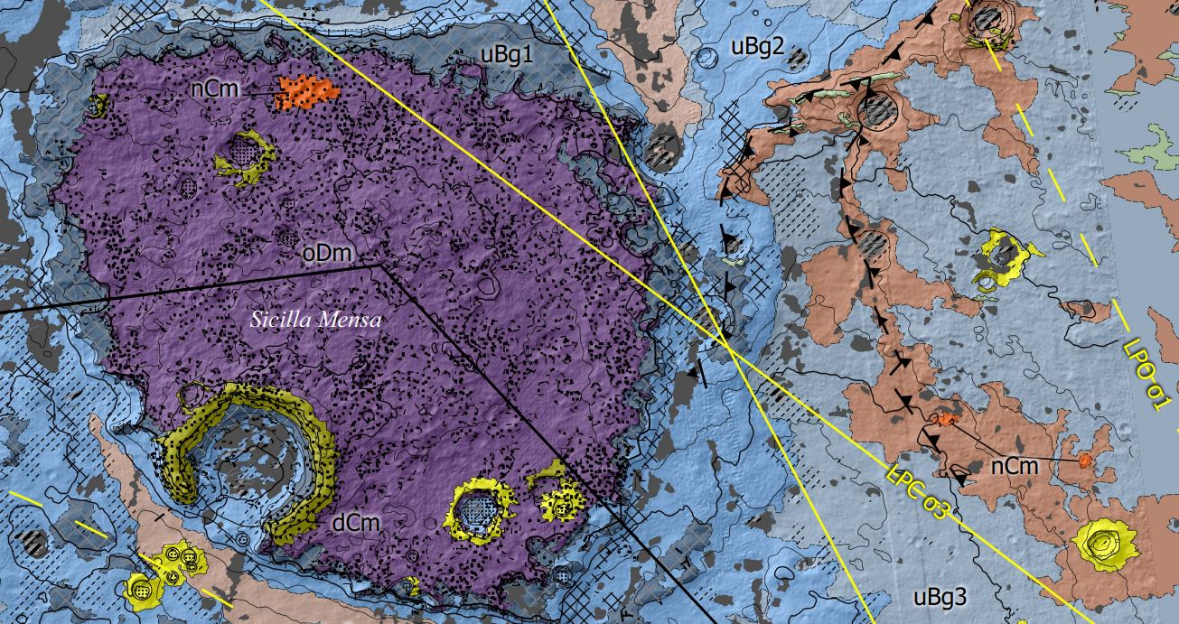
Where would be the most ideal landing site for the Artemis III crew in SpaceX’s Human Landing System (HLS)? This is what a recent study submitted to Acta Astronautica hopes to address as an international team of scientists investigated plausible landing sites within the lunar south pole region, which comes after NASA selected 13 candidate landing regions in August 2022 and holds the potential to enable new methods in determining landing sites for future missions, as well.

Continue reading “Artemis III Landing Sites Identified Using Mapping and Algorithm Techniques”

A New Way to Make Precise Maps of the Lunar Surface

Lunar surface

There was a time when maps of the Moon were created from telescopic observations and drawings. Indeed Sir Patrick Moore created maps of the Moon that were used during the historic Apollo landings. Now researchers have enhanced a technique to create accurate maps from existing satellite images. Their approach uses a technique called ‘shape-from-shading’ and involves analyzing shadows to estimate the features and shape of the terrain. Future lunar missions will be able to use the maps to identify hazards on the surface making them far safer. 

Continue reading “A New Way to Make Precise Maps of the Lunar Surface”

The ESA’s Mars Rover Gets a New Map

European scientists have created an extremely detailed geological map of Oxia Planum, the landing site for the ESA's Rosalind Franklin rover. Not only will it help guide the rover's driving, it will help the rover sample the most promising sites. Image Credit: Fawdon et al. 2024.

Rosalind Franklin, the ESA’s Mars rover, is scheduled to launch no sooner than 2028. Its destination is Oxia Planum, a wide clay-bearing plain to the east of Chryse Planitia. Oxia Planum contains terrains that date back to Mars’ Noachian Period, when there may have been abundant surface water, a key factor in the rover’s mission.

Continue reading “The ESA’s Mars Rover Gets a New Map”

Astronomy Cast Ep. 503: Gravity Mapping

The Earth looks like a perfect sphere, but down here on the surface we see that there are mountains, rivers, oceans, glaciers, all kinds of features with different densities and shapes. Scientists can map this produce a highly detailed gravity map of our planet. And it turns out, this is very useful for other worlds too.

We usually record Astronomy Cast every Friday at 3:00 pm EST / 12:00 pm PST / 20:00 PM UTC. You can watch us live on AstronomyCast.com, or the AstronomyCast YouTube page.

Visit the Astronomy Cast Page to subscribe to the audio podcast!

If you would like to support Astronomy Cast, please visit our page at Patreon here – https://www.patreon.com/astronomycast. We greatly appreciate your support!

If you would like to join the Weekly Space Hangout Crew, visit their site here and sign up. They’re a great team who can help you join our online discussions!

Astronomy Cast Ep. 365: Gaia

The European Gaia spacecraft launched about a year ago with the ambitious goal of mapping one billion years in the Milky Way. That’s 1% of all the stars in our entire galaxy, which it will monitor about 70 times over its 5-year mission. If all goes well, we’ll learn an enormous amount about the structure, movements and evolution of the stars in our galaxy. It’ll even find half a million quasars.
Continue reading “Astronomy Cast Ep. 365: Gaia”