Plaque on the exterior of Mars Science Laboratory, aka “Curiosity” (NASA/JPL-Caltech/MSSS)
Curiosity drops a few rather big names in recent images taken with its MAHLI (Mars Hand Lens Imager) camera: here we see a plaque affixed to its surface bearing the names and signatures of U.S. President Barack Obama, Vice President Joe Biden, Office of Science and Technology Director John Holdren, NASA Administrator Charles Bolden and other key figures responsible for making the Mars Exploration Program possible.
You never know… even on another planet it can’t hurt to have friends in high places!
The image was captured by MAHLI on September 19, the 44th sol of the MSL mission. (See the original raw downlink here.)
The rectangular plaque is made of anodized aluminum, measuring 3.94 inches (100 mm) high by 3.23 inches (82 mm) wide. It’s attached to the front left side of Curiosity’s deck with four bolts. (Explore Curiosity in 3D here.)
Dust, pebbles and variously-sized bits of Mars can be seen scattered around the plaque and deck, leftover detritus from the rover’s landing.
The complete list of signatures is:
Barack Obama, President, United States of America
Joe Biden, Vice President
John P. Holdren, Director, Office of Science and Technology Policy
Charles F. Bolden, Jr., Administrator, National Aeronautics and Space Administration
Edward J. Weiler, Associate Administrator, Science Mission Directorate (2008–2011)
James Green, Director, Planetary Sciences Division
Doug McCuistion, Director, Mars Exploration Program
Michael Meyer, Program Scientist, Mars Exploration Program
David Lavery, Program Executive, Mars Science Laboratory
In another image taken on the same sol, Curiosity shows some national pride with a circular medallion decorated with the stars and stripes of the American flag. The 68-mm-wide circular aluminum plate is affixed to one of the rover’s rocker arms. It’s just one of its four “mobility logos” — the others having the NASA logo, the JPL logo and the Curiosity mission logo.
Curiosity’s “stars and stripes” American flag mobility logo (NASA/JPL-Caltech/MSSS)
The main purpose of Curiosity’s MAHLI camera is to acquire close-up, high-resolution views of rocks and soil at the rover’s Gale Crater field site. Developed for NASA by Malin Space Science Systems in San Diego, CA, the camera is capable of focusing on any target at distances of about 0.8 inch (2.1 centimeters) to infinity, providing versatility for other uses, such as views of the rover itself from different angles.
The streak on Google Mars misinterpreted as a secret Mars base.
[/caption]
It’s time for another episode of “Conspiracy Theory of the Week.” This one involves a supposed secret space station on Mars. The You Tube video showing “Bio Station Alpha” (below) went viral and was even reported on some mainstream media outlets. The station is supposedly a 700 ft x 150 ft structure on Mars and by some accounts is colored white with blue and red stripes. It was found on Google Mars by an “armchair astronaut” and breathless conspiracy bloggers have touted this as the most important discovery on Mars yet, and “proof!” that NASA is hiding their activities.
In reality, this is not a space station, a Mars base or any type of structure – created or natural — on the surface of the Red Planet. What shows up in this location on Google Mars is just a smattering of about 11 bad pixels from data dropout – a linear streak artifact likely caused by a cosmic ray hitting the Mars Express spacecraft while it was taking the image – and then that smudge has been badly distorted through image processing when it became part of Google Mars.
Here’s the image that is seen on Google Mars after processing, which includes very noticeable compression artifacts:
And now here’s the original image taken by the Mars Express High Resolution Stereo Camera image (H5620_0000_ND), taken on May 18, 2008 (and here’s the link to the original image):
Original Mars Express HRSC image of the location in question on Mars. Credit: ESA
This image really makes it clear this is an image artifact from a cosmic ray hit.
Here’s the same location taken by the MRO Context Camera (CTX) on January 25, 2010 (a crop of the same location as seen above from the original large CTX image, available here):
MRO's Context Camera (CTX) image MRO CTX B17_016407_2528_XN_72N029W of the same location. Credit: MSSS
In this image, each pixel represents a distance of about 6.25 meters, a higher resolution than what is available from the Mars Express spacecraft, which takes images at 10 meters per pixel. Obviously, there is no structure or anything unusual at that location, except for the northern polar sand dunes.
Harrison explained that the CTX acquires grayscale (black & white) images at 6 meters per pixel scale over a swath 30 kilometers wide and provides context images for the MRO HiRISE and CRISM cameras, which can take even higher resolution images. It is used to monitor changes occurring on the planet, and help the science team select critical science targets. The team at Malin Space Science Systems pores over the images looking for anything unusual. In this case, at this location, they found nothing.
“Every day, the images we acquired with CTX and MARCI the previous day are inspected by multiple sets of eyes,” Harrison told Universe Today. “We look at every single image for multiple reasons: checking the health of the instrument, monitoring weather conditions for future targeting of the cameras, and looking for anything geologically interesting.”
Harrison added that nearly all the operations folks on the team have Master’s degrees or Ph.D.s in geology or a related field.
“If we spot anything out of the ordinary, we look at previous images of the area, not just from CTX and MARCI, but from the Mars Global Survery’s Mars Orbiter Camera, the THEMIS VIS and IR on the Mars Odyssey spacecraft, the HRSC on Mars Express, and Viking,” Harrison said. “This lets us look at the features at different illumination angles, times of day, resolutions, etc. We know better than to speculate on something below the resolution of our cameras, so if we see something in CTX that’s worth following up on at a higher resolution, we ask HiRISE to shoot it. The same thing was true for MOC, following up on things observed in the low-resolution wide angle images with high-resolution narrow angle images.”
Clearly, this region has been imaged and examined previously, with absolutely nothing found by the top experts in the field. The region is so uninteresting that no one has requested for HiRISE — which can take images of 1-2 meters per pixel — to take any images of this area.
Harrison said CTX takes images of Mars that are up to 30 km wide and over 300 km long at a very high resolution. “This is a pretty big footprint with a relatively high resolution compared to previous cameras!” she said. “The size of that footprint has allowed us to cover over 60% of Mars at 6 meters per pixel in the 5 years MRO has been orbiting Mars. In addition to mapping, we use CTX to acquire stereo coverage of key areas, as well as to monitor hundreds of locations on Mars for changes such as new impact craters and dust activity.”
If there were something unusual on Mars, the people at NASA, ESA, MSSS and anyone monitoring Mars would have imaged this site repeatedly with the best cameras available. They would love to find something unusual, groundbreaking and front-page worthy, and if they did would be shouting it from the rooftops, not hiding it.

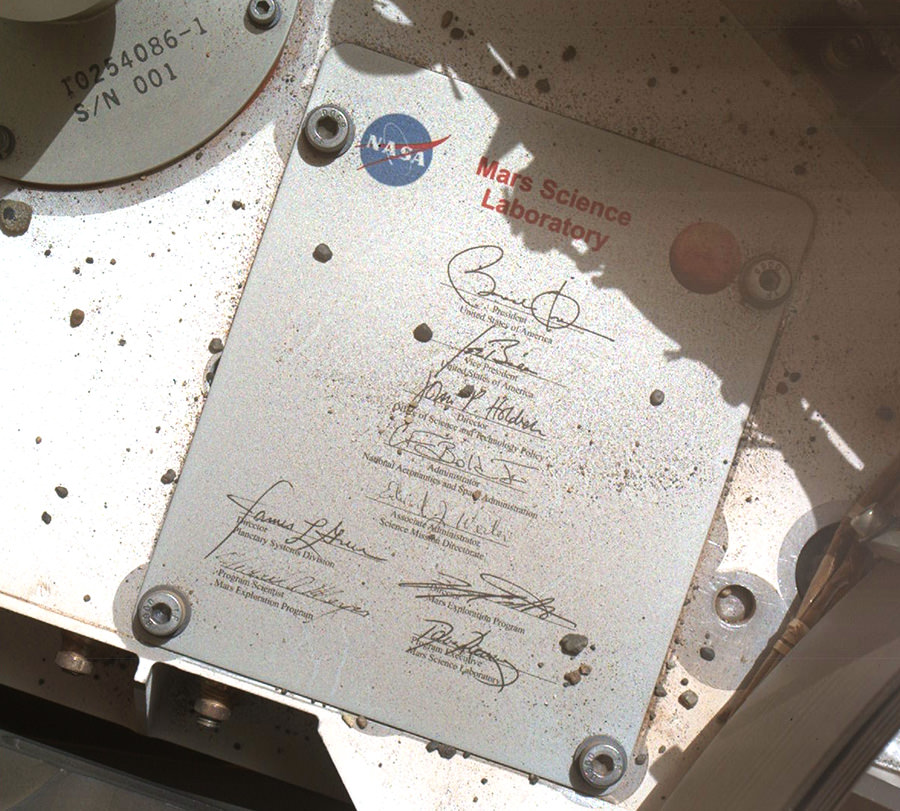


 image MRO CTX B17_016407_2528_XN_72N029W of the same location. Credit: MSSS")