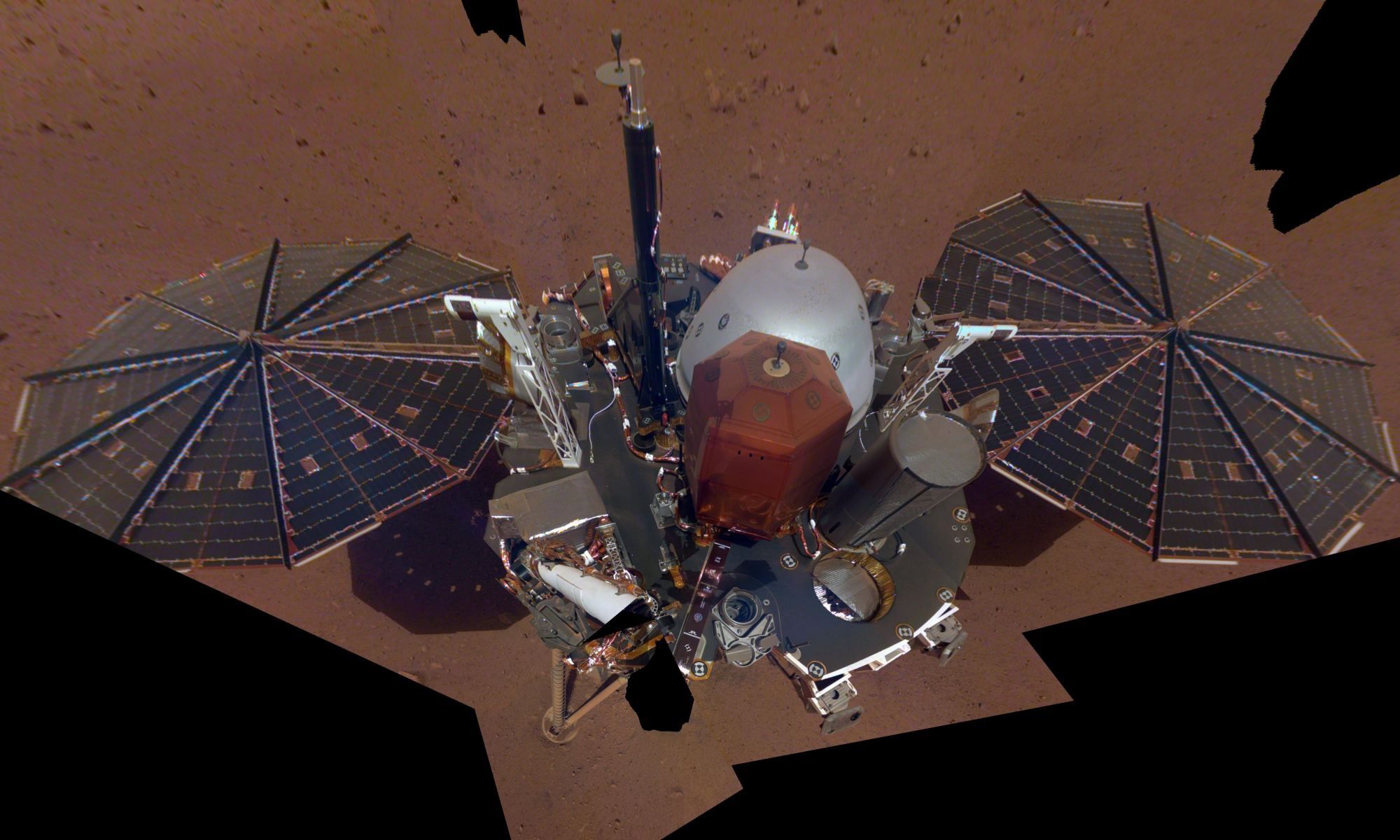
InSight's first full selfie on Mars. The selfie was taken on Dec. 6th, and is a mosaic of 11 images taken with its Instrument Deployment Camera on the elbow of its robotic arm. Image Credit: NASA/JPL-Caltech
InSight has been on the Martian surface for almost three weeks, prepping itself for all the science it’s going to do. But in the meantime, it’s doing what any self-respecting, modern robotic lander does: Taking pictures of itself. And now NASA has released InSight’s first selfie for all the lander’s adoring fans and Instagram followers.
InSight is on Mars to study the interior of the rocky planet, and provide clues into how rocky planets form, both here in our Solar System, and in distant systems. It’s got a suite of instruments to do that with, including a device that will drill 5m (16 ft.) deep into the planet to measure how heat flows through the core of Mars. But it’s taking a cautious approach to that, using its time wisely to select the perfect spot to deploy its instruments.
One of two Mars InSight's 7-foot (2.2 meter) wide solar panels was imaged by the lander's Instrument Deployment Camera, which is fixed to the elbow of its robotic arm. Credits: NASA/JPL-Caltech
Just two weeks ago, NASA’s Interior Exploration using Seismic Investigations, Geodesy and Heat Transport (InSight) lander touched down on the surface of Mars. In the hours that followed, mission controllers at NASA-JPL received confirmation that the lander had deployed its solar arrays and was commencing scientific operations.
And in what was sure to be a treat for space exploration enthusiasts, the lander recently provided the first ever experience of what it “sounds” like to be on Mars. The sounds were caught by an air pressure sensor inside the lander and the seismometer instrument that is awaiting deployment to the surface. Together, they recorded the low rumble caused by Martian winds that blew around the lander’s location on Dec. 1st.
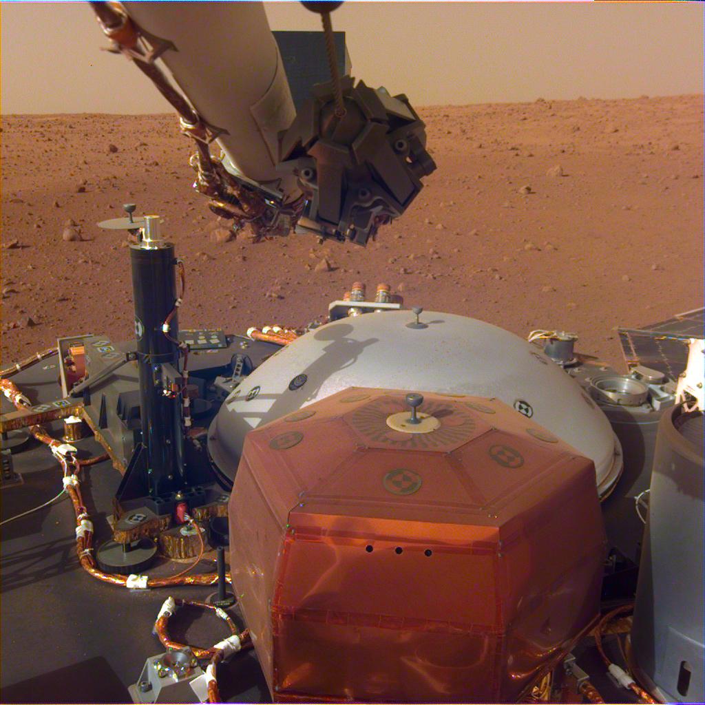
This image was taken by the InSight Lander's Instrument Deployment Camera mounted on the lander's robotic arm. The stowed grapple on the end of the arm is folded in, but it will unfold and be used to deploy the lander's science instrument. The copper-colored hexagonal object is the protective cover for the seismometer, and the grey dome behind it is a wind and thermal shield, which will be placed over the seismometer after its deployed. The black cyliner on the left is the heat probe, which will drill up to 5 meters into the Martian surface. Image: NASA/JPL-Caltech
Some new images sent home by the InSight Lander show the robotic arm and the craft’s instruments waiting on deck, on the surface of Mars. The lander is still having its systems tested, and isn’t quite ready to get to work. It’ll use its arm to deploy its science instruments, including a drill that will penetrate up to 5 meters (16 ft.) deep into the Martian surface.
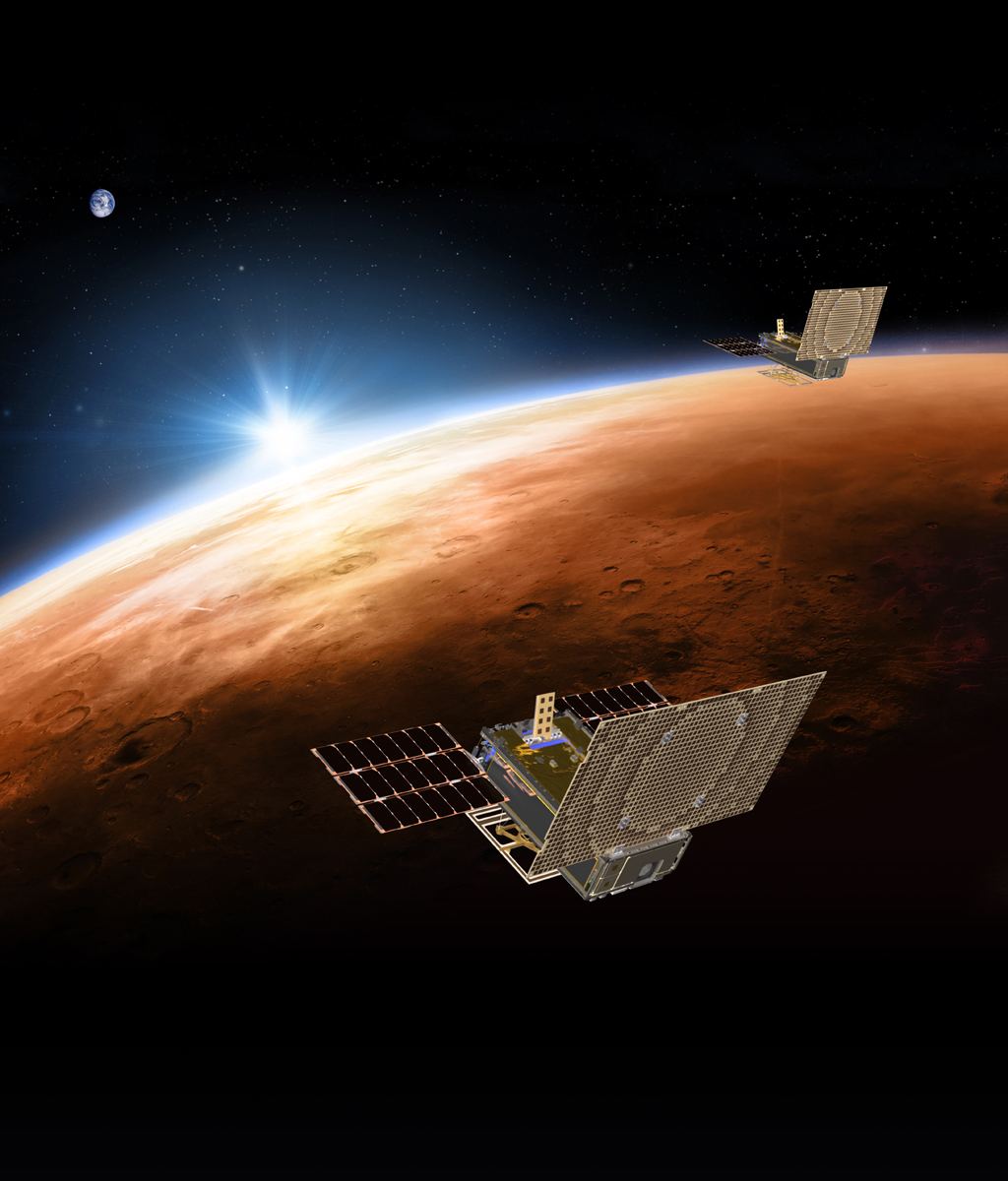
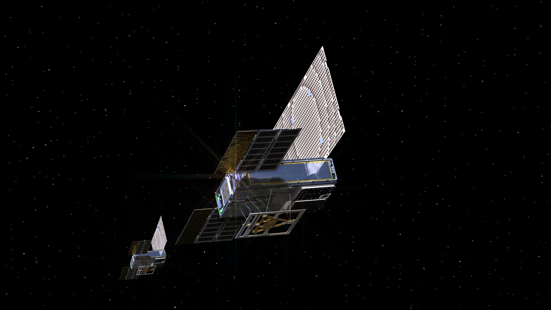
Artist's rendering of the twin Mars Cube One (MarCO) spacecraft flying over Mars with Earth in the distance. Credit: NASA/JPL-Caltech
Yesterday, NASA’s Mars InSight lander successfully touched down on the Martian surface after spending seven long months in space. Over the course of the next few hours, the lander began the surface operations phase of its mission, which involved deploying its solar arrays. The lander also managed to take some pictures of the surface, which showed the region where it will be studying Mars’ interior for the next two years.
In the midst of all that, another major accomplishment received only passing attention. This was the Mars Cube One (MarCO) mission, an experiment conducted by NASA to see if two experimental CubeSats could survive the trip to deep space. Not only did these satellites survive the journey, they managed to relay communications from the lander and even took some pictures of their own.
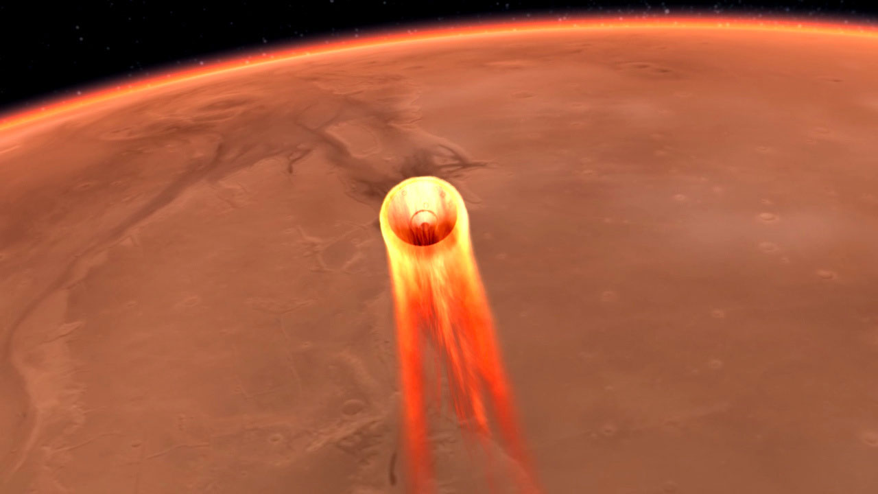
Artist's impression of the InSight Lander commencing its entry, descent and landing (EDL) phase to Mars. Credit: NASA
On of May 5th, 2018, NASA’s Interior Exploration using Seismic Investigations, Geodesy and Heat Transport (InSight) lander launched from Vandenburg Air Force Base atop an Atlas V rocket. Over the next seven months, the mission traveled some 458 million km (300 mi) to Mars for the sake of studying its deep interior and learn how this planet – and all the other terrestrial planets of the Solar System (like Earth) – formed.
At 11:47 am PST (2:47 pm EST), after a seven month journey, NASA’s InSight Lander entered the Martian atmosphere to begin the entry, descent and landing (EDL) phase of its mission. Over the course of the next five minutes, the mission controllers at NASA-JPL watched eagerly as the spacecraft went through the careful process of conducting a textbook landing.
The site where the InSight lander will set down, relief map based on data provided by the Mars Global Surveyor (MGS). Credit: NASA/JPL-Caltech
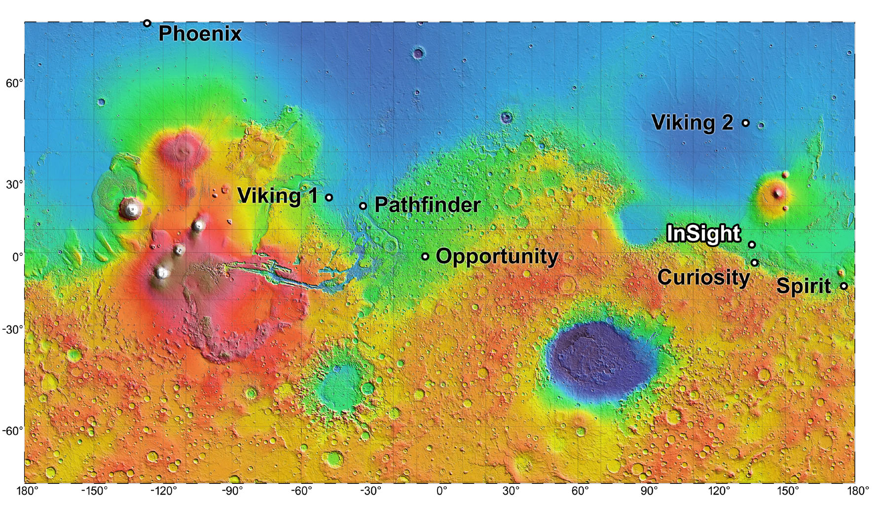
In the course of exploring Mars, the many landers, rovers and orbiters that have been sent there have captured some truly stunning images of the landscape. Between Spirit, Opportunity,Curiosity, the Mars Reconnaissance Orbiter (MRO) and others, we have treated to some high-definition images over the years of sandy dunes, craters and mountains – many of which call to mind places here on Earth.
However, if one were to describe the region where NASA’s Interior Exploration using Seismic Investigations, Geodesy and Heat Transport (InSight) lander will be landing (on Nov. 26th, 2018), the word “plain” would probably come to mind (and it would be appropriate). This region is known as Elysium Planitia, and it is where InSight will spend the next few years studying Mars’ interior structure and tectonic activity for the sake of learning more about its history.
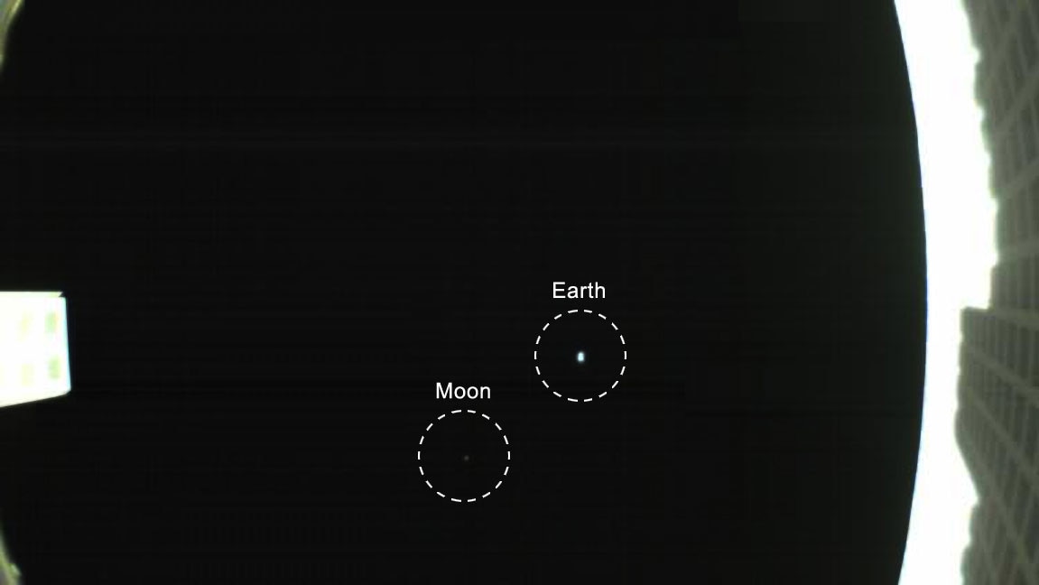
The first image captured by one of NASA's Mars Cube One (MarCO) CubeSats. The image, which shows both the CubeSat's unfolded high-gain antenna at right and the Earth and its moon in the center, was acquired by MarCO-B on May 9. Credit: NASA/JPL-Caltech
In 1990, the Voyager 1spaceprobe took a picture of Earth when it was about 6.4 billion km (4 billion mi) away. In this image, known as the “pale blue dot“, Earth and the Moon appeared as mere points of light because of the sheer distance involved. Nevertheless, it remains an iconic photo that not only showed our world from space, but also set long-distance record.
As it turns out, NASA set another long-distance record for CubeSats last week (on May. 8th, 2018) when a pair of small satellites called Mars Cube One (MarCO) reached a distance of 1 million km (621,371 mi) from Earth. On the following day, one of the CubeSats (MarCO-B, aka. “Wall-E”) used its fisheye camera to take its own “pale blue dot” photo of the Earth-Moon system.
The two CubeSats were launched on May 5th along with the Interior Exploration using Seismic Investigations, Geodesy and Heat Transport (InSight) lander, which is currently on its way to Mars to explore the planet’s interior structure. As the first CubeSats to fly to deep pace, the purpose of the MarCO mission is to demonstrate if CubeSats are capable of acting as a relay with long-distance spacecraft.
An artist’s rendering of the twin Mars Cube One (MarCO) spacecraft as they fly through deep space. Credit: NASA/JPL-Caltech
To this end, the probes will be responsible for monitoring InSight as it makes its landing on Mars in late November, 2018. The photo of Earth and the Moon was taken as part of the process used by the engineering team to confirm that the spacecraft’s high-gain antenna unfolded properly. As Andy Klesh, MarCO’s chief engineer at NASA’s Jet Propulsion Laboratory, indicated in a recent NASA press release:
“Consider it our homage to Voyager. CubeSats have never gone this far into space before, so it’s a big milestone. Both our CubeSats are healthy and functioning properly. We’re looking forward to seeing them travel even farther.”
This technology demonstration, and the long-distance record recently set by MarCO satellites, provides a good indication of just how far CubeSats have come in the past few years. Originally, CubeSats were developed to teach university students about satellites, but have since become a major commercial technology. In addition to providing vast amounts of data, they have proven to be a cost-effective alternative to larger, multi-million dollar satellites.
The MarCO CubeSats will be there when the InSight lander accomplishes the most difficult part of its mission, which is entering Mars’ extremely thin atmosphere (which makes landings extremely challenging). As the lander travels to Mars, MarCO-A and B will travel along behind it and (should they make it all the way to Mars) radio back data about InSight as it enters the atmosphere and descends to the planet’s surface.
Artist’s interpretation of the InSight mission on the ground on Mars. Credit: NASA
The job of acting as a data relay will fall to NASA’s Mars Reconnaissance Orbiter (MRO), which has been in orbit of Mars since 2006. However, the MarCOs will also be monitoring InSight to see if future missions will be capable of bringing their own relay to Mars, rather than having to rely on an orbiter that is already there. They may also demonstrate a number of experimental technologies, which includes their radio and propulsion systems.
The main attraction though, are the high-gain antennas which will be providing information on InSights’ progress. At the moment, the team has received early confirmation that the antennas have successfully deployed, but they will continue to test them in the weeks ahead. If all goes according to plan, the MarCOs could demonstrate the ability of CubeSats to act not only as relays, but also their ability to gather information on other planets.
In other words, if the MarCOs are able to make it to Mars and track InSight’s progress, NASA and other agencies may contemplate mounting full-scale missions using CubeSats – sending them to the Moon, Mars, or even beyond. Later this month, the MarCOs will attempt their first trajectory correction maneuvers, which will be the first such maneuver are performed by CubeSats.
In the meantime, be sure to check out this video of the MarCO mission, courtesy of NASA 360:
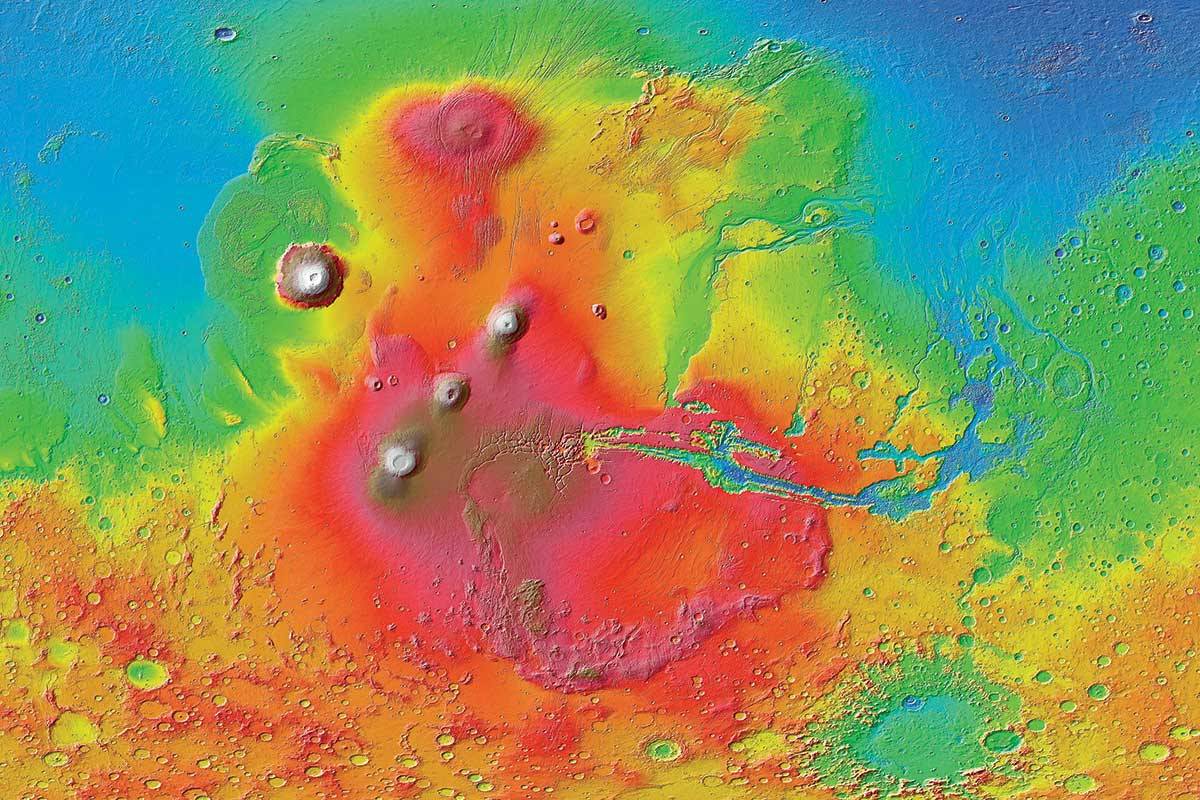
Image of the Tharsis region of Mars taken by Mars Express featuring several prominent shield volcanoes includes the massive Olympus Mons (at left). Credit: ESA
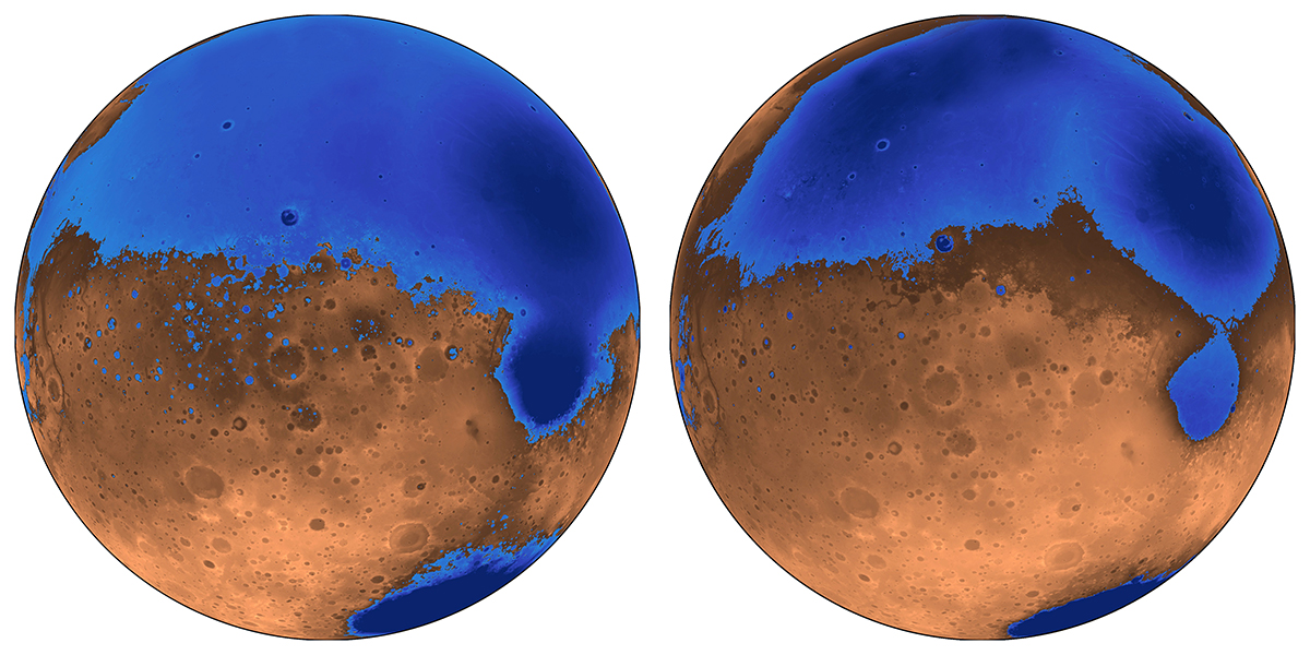
Thanks to the many missions that have been studying Mars in recent years, scientists are aware that roughly 4 billion years ago, the planet was a much different place. In addition to having a denser atmosphere, Mars was also a warmer and wetter place, with liquid water covering much of the planet’s surface. Unfortunately, as Mars lost its atmosphere over the course of hundreds of millions of years, these oceans gradually disappeared.
When and where these oceans formed has been the subject of much scientific inquiry and debate. According to a new study by a team of researchers from UC Berkeley, the existence of these oceans was linked to the rise of the Tharis volcanic system. They further theorize that these oceans formed several hundred millions years earlier than expected and were not as deep as previously thought.
The early ocean known as Arabia (left, blue) would have looked like this when it formed 4 billion years ago on Mars, while the Deuteronilus ocean (right), about 3.6 billion years old, had a smaller shoreline. Credit: Robert Citron/UC Berkeley
As Michael Manga explained in a recent Berkeley News press release:
“The assumption was that Tharsis formed quickly and early, rather than gradually, and that the oceans came later. We’re saying that the oceans predate and accompany the lava outpourings that made Tharsis.”
The debate over the size and extent of Mars’ past oceans is due to some inconsistencies that have been observed. Essentially, when Mars lost its atmosphere, its surface water would have frozen to become underground permafrost or escaped into space. Those scientists who don’t believe Mars once had oceans point to the fact that the estimates of how much water could have been hidden away or lost is not consistent with estimates on the oceans’ sizes.
What’s more, the ice that is now concentrated in the polar caps is not enough to create an ocean. This means that either less water was present on Mars than previous estimates indicate, or that some other process was responsible for water loss. To resolve this, Citron and his colleagues created a new model of Mars where the oceans formed before or at the same time as Mars’ largest volcanic feature – Tharsis Montes, roughly 3.7 billion years ago.
A colorized image of the surface of Mars taken by the Mars Reconnaissance Orbiter. The line of three volcanoes is the Tharsis Montes, with Olympus Mons to the northwest. Valles Marineris is to the east. Image: NASA/JPL-Caltech/ Arizona State University
Since Tharsis was smaller at the time, it did not cause the same level of crustal deformation that it did later. This would have been especially true of the plains that cover most the northern hemisphere and are believed to have been an ancient seabed. Given that this region was not subject to the same geological change that would have come later, it would have been shallower and held about half the water.
“The assumption was that Tharsis formed quickly and early, rather than gradually, and that the oceans came later,” said Manga. “We’re saying that the oceans predate and accompany the lava outpourings that made Tharsis.”
In addition, the team also theorized that the volcanic activity that created Tharsis may have been responsible for the formation of Mars’ early oceans. Basically, the volcanoes would have spewed gases and volcanic ash into the atmosphere that would have led to a greenhouse effect. This would have warmed the surface to the point that liquid water could form, and also created underground channels that allowed water to reach the northern plains.
Their model also counters other previous assumptions about Mars, which are that its proposed shorelines are very irregular. Essentially, what is assumed to have been “water front” property on ancient Mars varies in height by as much as a kilometer; whereas on Earth, shorelines are level. This too can be explained by the growth of the Tharsis volcanic region, roughly 3.7 billion years ago.
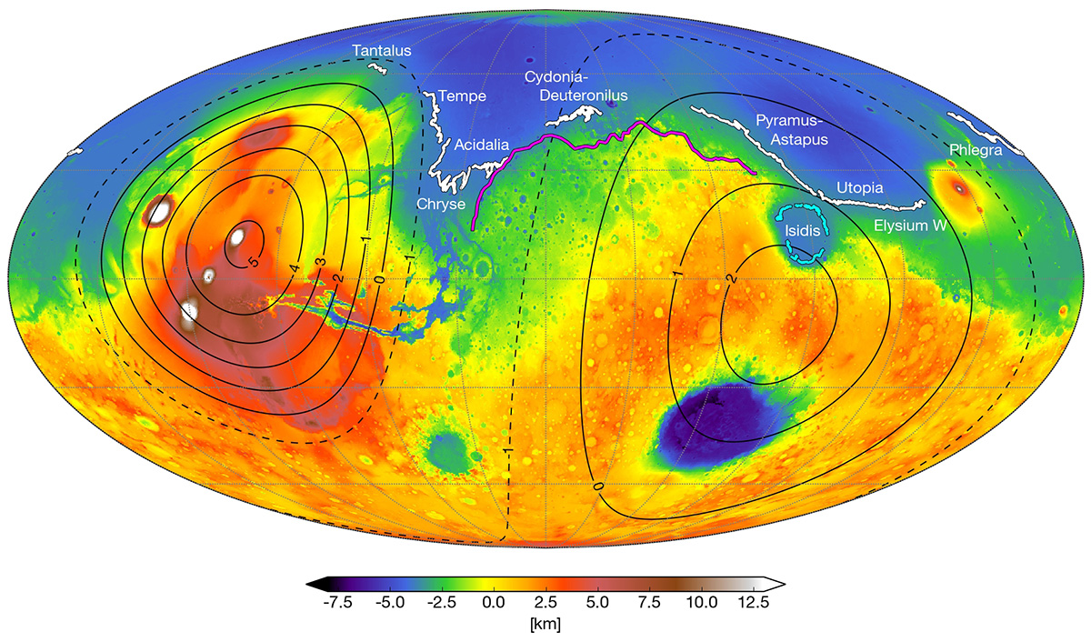
A map of Mars today shows where scientists have identified possible ancient shoreline that may have been etched by intermittent oceans billions of years ago. Credit: Robert Citron/UC Berkeley.
Using current geological data of Mars, the team was able to trace how the irregularities we see today could have formed over time. This would have began when Mars first ocean (Arabia) started forming 4 billion years ago and was around to witness the first 20% of Tharsis Montes growth. As the volcanoes grew, the land became depressed and the shoreline shifted over time.
Similarly, the irregular shorelines of a subsequent ocean (Deuteronilus) can be explained by this model by indicating that it formed during the last 17% of Tharsis’ growth – roughly 3.6 billion years ago. The Isidis feature, which appears to be an ancient lakebed slightly removed from the Utopia shoreline, could also be explained this way. As the ground deformed, Isidis ceased being part of the northern ocean and became a connected lakebed.
“These shorelines could have been emplaced by a large body of liquid water that existed before and during the emplacement of Tharsis, instead of afterwards,” said Citron. This is certainly consistent with the observable effect that Tharsis Mons has had on the topography of Mars. It’s bulk not only creates a bulge on the opposite side of the planet (the Elysium volcanic complex), but a massive canyon system in between (Valles Marineris).
This new theory not only explains why previous estimates about the volume of water in the northern plains were inaccurate, it can also account for the valley networks (cut by flowing water) that appeared around the same time. And in the coming years, this theory can be tested by the robotic missions NASA and other space agencies are sending to Mars.
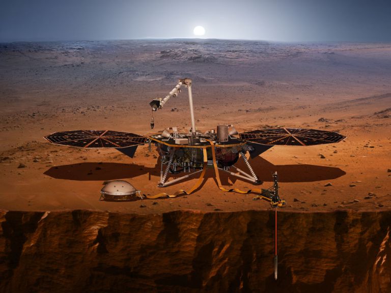
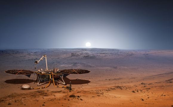
This artist’s concept from August 2015 depicts NASA’s InSight Mars lander fully deployed for studying the deep interior of Mars. Credit: NASA/JPL-Caltech
Consider NASA’s Interior Exploration using Seismic Investigations, Geodesy and Heat Transport (InSight) mission, which is scheduled for launch in May, 2018. Once it reaches Mars, this lander will use a suite of advanced instruments – which includes a seismometer, temperature probe and radio science instrument – to measure Mars interior and learn more about its geological activity and history.
Among other things, NASA anticipates that InSight might detect the remains of Mars’ ancient ocean frozen in the interior, and possibly even liquid water. Alongside the Mars 2020 rover, the ExoMars 2020, and eventual crewed missions, these efforts are expected to provide a more complete picture of Mars past, which will include when major geological events took place and how this could have affected the planet’s ocean and shorelines.
The more we learn about what happened on Mars over the past 4 billion years, the more we learn about the forces that shaped our Solar System. These studies also go a long way towards helping scientists determine how and where life-bearing conditions can form. This (we hope) will help us locate life it in another star system someday!
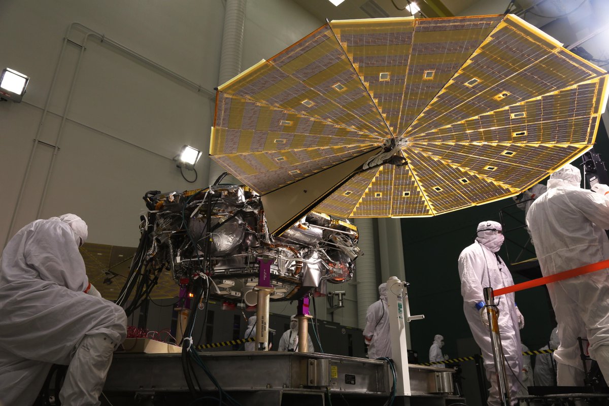
The Insight lander responds to commands to spread its solar arrays during a January 23, 2018 test at the Lockheed Martin clean room in Littleton, Colorado. Image: Lockheed Martin Space
May 2018 is the launch window for NASA’s next mission to Mars, the InSight Lander. InSight is the next member of what could be called a fleet of human vehicles destined for Mars. But rather than working on the question of Martian habitability or suitability for life, InSight will try to understand the deeper structure of Mars.
InSight stands for Interior Exploration using Seismic Investigations, Geodesy and Heat Transport. InSight will be the first robotic explorer to visit Mars and study the red planet’s deep interior. The work InSight does should answer questions about the formation of Mars, and those answers may apply to the history of the other rocky planets in the Solar System. The lander, (InSight is not a rover) will also measure meteorite impacts and tectonic activity happening on Mars currently.
This video helps explain why Mars is a good candidate to answer questions about how all our rocky planets formed, not just Mars itself.
InSight was conceived as part of NASA’s Discovery Program, which are missions focused on important questions all related to the “content, origin, and evolution of the solar system and the potential for life elsewhere”, according to NASA. Understanding how our Solar System and its planets formed is a key part of the Discovery Program, and is the question InSight was built to answer.
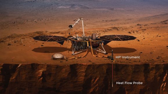
This artist’s illustration of InSight on a photo background of Mars shows the lander fully deployed. The solar arrays are open, and in the foreground two of its instruments are shown. On the left is the SEIS instrument, and on the right is the HP3 probe. Image: NASA/Lockheed Martin
To do its work, InSight will deploy three instruments: SEIS, HP³, and RISE.
SEIS
This is InSight’s seismic instrument, designed to take the Martian pulse. It stands for Seismic Experiment for Internal Structure.
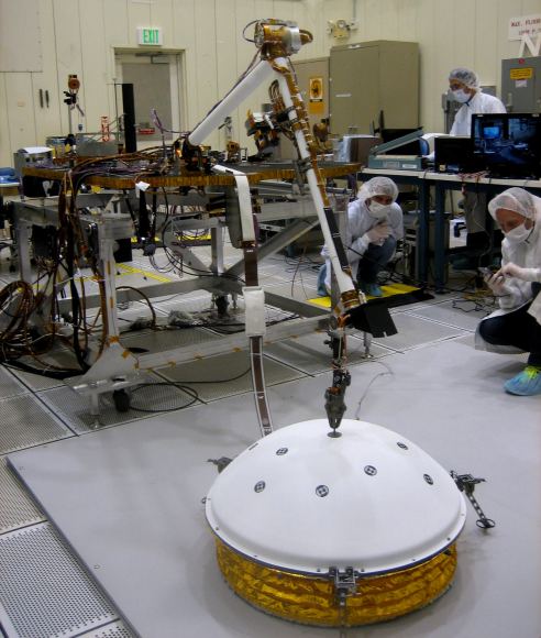
In this image, InSight’s Instrument Deployment Arm is practicing placing SEIS on the surface. Image: NASA/Lockheed Martin
SEIS sits patiently under its dome, which protects it from Martian wind and thermal effects, and waits for something to happen. What’s it waiting for? For seismic waves caused by Marsquakes, meteorite impacts, or by the churning of magma deep in the Martian interior. These waves will help scientists understand the nature of the material that first formed Mars and the other rocky planets.
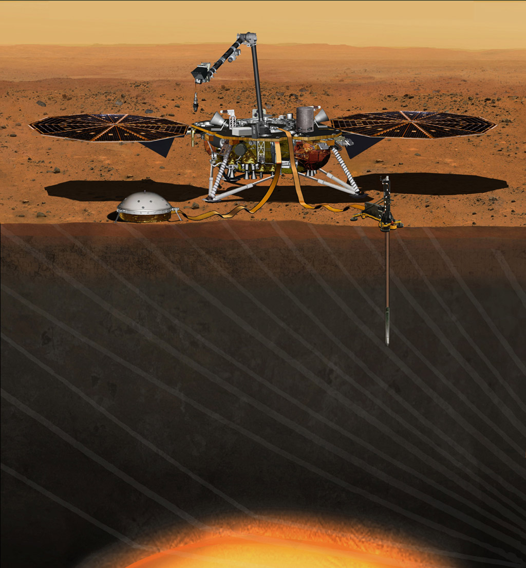
HP³
HP³ is InSight’s heat probe. It stands for Heat Flow and Physical Properties Probe. Upon deployment on the Martian surface, HP³ will burrow 5 meters (16 ft.) into Mars. No other instrument has ever pierced Mars this deeply. Once there, it will measure the heat flowing deeply within Mars.
In this image, the Heat Flow and Physical Properties Probe is shown inserted into Mars. Image: NASA
Scientists hope that the heat measured by HP³ will help them understand whether or not Mars formed from the same material that Earth and the Moon formed from. It should also help them understand how Mars evolved after it was formed.
RISE
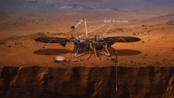
RISE stands for Rotation and Interior Structure Experiment. RISE will measure the Martian wobble as it orbits the Sun, by precisely tracking InSight’s position on the surface. This will tell scientists a lot about the deep inner core of Mars. The idea is to determine the depth at which the Martian core is solid. It will also tell us which elements are present in the core. Basically, RISE will tell us how Mars responds to the Sun’s gravity as it orbits the Sun. RISE consists of two antennae on top of InSight.
The two RISE antennae are shown in this image. RISE will reveal information about the Martian core by tracking InSight’s position while Mars orbits the Sun. Image: NASA/Lockheed Martin
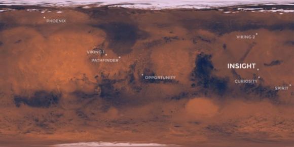
InSight will land at Elysium Planitia which is a flat and smooth plain just north of the Martian equator. This is considered a perfect location or InSight to study the Martian interior. The landing sight is not far from where Curiosity landed at Gale Crater in 2012.
InSight will land at Elysium Planitia, just north of the Martian equator. Image: NASA/JPL-CalTech
InSight will be launched to Mars from Vandenberg Air Force Base in California by an Atlas V-401 rocket. The trip to Mars will take about 6 months. Once on the Martian surface, InSight’s mission will have a duration of about 728 Earth days, or just over 1 Martian year.
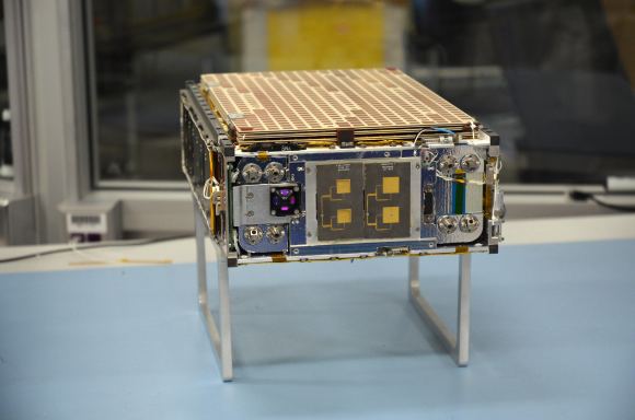
InSight won’t be launching alone. The Atlas that launches the lander will also launch another NASA technology experiment. MarCO, or Mars Cube One, is two suitcase-size CubeSats that will travel to Mars behind InSight. Once in orbit around Mars, their job is to relay InSight data as the lander enters the Martian atmosphere and lands. This will be the first time that miniaturized CubeSat technology will be tested at another planet.
One of the MarCO Cubesats that will be launched with InSight. This will be the first time that CubeSat technology will be tested at another planet. Image: NASA/JPL-CalTech
If the MarCO experiment is successful, it could be a new way of relaying mission data to Earth. MarCO will relay news of a successful landing, or of any problems, much sooner. However, the success of the InSight lander is not dependent on a successful MarCO experiment.