A Noctilucent Masterpiece

Noctilucent clouds over Reykjavíc. © Örvar Atli Þorgeirsson

[/caption]

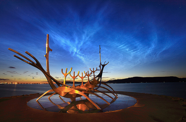
Night-shining “noctilucent” clouds create a magical glow in the night skies over Reykjavíc, Iceland in this beautiful photo by Örvar Atli Þorgeirsson, taken on August 6. In the foreground is “The Sun Voyager” (Sólfar), an iconic steel sculpture located on the city waterfront representing a Viking ship.

Örvar did not set out to photograph this rare atmospheric phenomenon but had instead intended to shoot aurora triggered by recent solar outbursts.

“The forecast on the 6th of August was predicting extreme aurora activity,” Örvar says in his Flickr description. “Even though it was very early August and the night would not get fully dark I went out as the aurora can be seen in deep twilight conditions. I saw the aurora for 1 – 2 minutes that night. I did not get a good picture of it though. Instead we witnessed this even rarer phenomenon called noctilucent clouds.”

Noctilucent clouds are extremely high-level clouds made located in the mesosphere, around 76 to 85 kilometers (47 to 53 miles) high… nearly at the very edge of space. (Most commercial airplanes fly between 6 and 7 miles high.) They are high enough to reflect sunlight coming from beyond the horizon long after night has fallen over the land below. They usually appear as a wispy web of blue, white, purple and orange tendrils stretched across the sky.

“These clouds where extremely beautiful to look at and reminded me of the aurora but where much more stationary and had this beautiful blue color.”

–  Örvar Atli Þorgeirsson

Noctilucent clouds are mainly visible at latitudes between 50º – 70º north and south during the months of June and July. This means Reykjavíc, located right in the middle, can get great views. (Of course it helps to have a talented photographer like Örvar to capture them so nicely!)

Oddly enough noctilucent clouds are a relatively recent phenomenon, only having been recorded for about 120 years. They have been connected with space shuttle passages through the upper atmosphere, and it’s even been suggested that they may be associated with the 1908 Tunguska impact.

Read more about noctilucent clouds here.

Image © Örvar Atli Þorgeirsson. All rights reserved. Used with permission.

_____________________

Jason Major is a graphic designer, photo enthusiast and space blogger. Visit his website Lights in the Dark and follow him on Twitter @JPMajor or on Facebook for the most up-to-date astronomy news and images!

Spectacular Footage, Satellite Images of Eyjafjallajokull Volcano in Iceland

NASA's Terra Satellite captured this image on April 15, 2010 of the volcano and resulting ash plume. NASA image by Jeff Schmaltz, MODIS Rapid Response Team at NASA GSFC.

A volcano under a glacier in Iceland erupted Wednesday, melting ice, shooting smoke and steam into the air and forcing hundreds of people to leave their homes. The resulting ash plume has also halted air traffic over much of Europe. Scientists said the eruption under the ice cap was 10 to 20 times more powerful than an eruption from the that happened from the Eyjafjallajokullin Volcano late last month. “This is a very much more violent eruption because it’s interacting with ice and water,” said Andy Russell, an expert in glacial flooding at the University of Newcastle in northern England, in an article on the CBC website. The dramatic footage in the video here was released today, April 15, and satellite images, below, show how far the ash plume has traveled.

[/caption]

The iceland volcano sent a plume of ash and steam across the North Atlantic prompting airspace closures in the United Kingdom, Ireland, France, and Scandinavia, which then had a ripple effect, disrupting flights to and from other countries as well. Authorities could not say how long the airspace closure would last, and the ash’s spread threatened to force closures of additional airspace over the coming days.

NASA's EO-1 Satellite took this image on April 1, 2010. NASA image by Robert Simmon, using ALI data from the EO-1 team

This natural-color satellite image shows the area of the eruption on April 1, when a new vent opened up. The image was acquired by the Advanced Land Imager (ALI) aboard NASA’s Earth Observing-1 (EO-1) satellite.

The volcano, about 120 kilometres east of Reykjavik, erupted March 20 after almost 200 years of silence.

Watch an animation from ESA of how the plume traveled.

Pall Einarsson, a geophysicist at the University of Iceland, said magma was melting a hole in the thick ice covering the volcano’s crater, sending water coursing down the glacier, and causing widespread flooding.

Iceland’s main coastal ring road was closed near the volcano, and workers smashed a hole in the highway in a bid to give the rushing water a clear route to the coast and prevent a major bridge from being swept away.

Sources: CBC, NASA Earth Observatory, ESA