Ancient Snow Shaped A Martian Basin That’s Half The Size Of Brazil

Perspective view of Hellas Basin taken with the High Resolution Stereo Camera on ESA’s Mars Express in January 2014, and released in July 2014. Credit: ESA/DLR/FU Berlin

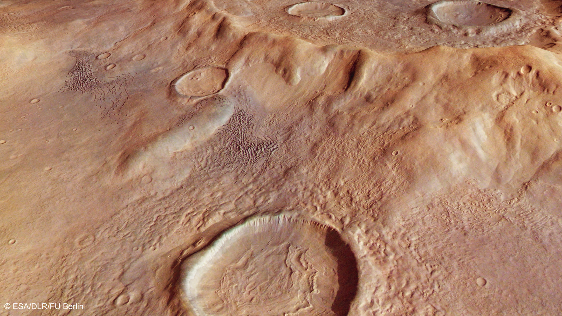
Such great heights! A mountain chain peeks in the background of this new view of Hellas Basin, based on information taken by a European spacecraft circling the Red Planet.

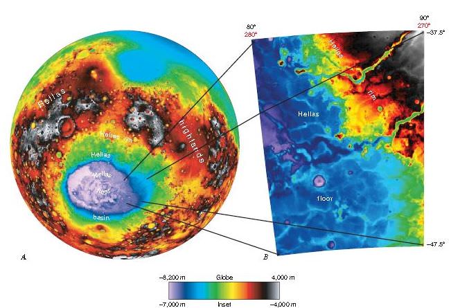
Beyond the pretty picture is a tale of how snow behaved on the Martian surface, according to the European Space Agency. The vast basin is about half the size of Brazil.

The wrinkled view of that crater in front is a product of snowing and freezing that took place when the Martian surface was wetter, ESA said.

A map of the Hellas basin in the southern hemisphere of Mars, as well as the rocky Hellespontus Montes. Image taken by the High Resolution Stereo Camera on ESA’s Mars Express. Credit: NASA MGS MOLA Science Team/Freie Universitaet Berlin

“During this period, snow fell and covered the surface and later moved downhill into the crater. Once inside the crater, the snow became trapped and soon covered by surface dust, before compacting to form ice. The number of concentric lines indicates many cycles of this process and it is possible that craters like these may still be rich in ice hidden beneath just tens of metres of surface debris.”

Additionally, the high hill chain in the back (called Hellespontus Montes) is a remnant of how Hellas basin was formed, the agency said.

“This feature is a product of the final stages of the formation of the vast Hellas impact basin itself, most likely as the basin walls – which were first pushed outwards by the extraordinary forces at work during the formation of the basin – later collapsed and sank inwards to create the observed stair-stepped shape.”

The image was taken by ESA’s Mars Express spacecraft, which is just one of several robotic emissaries circling the Red Planet.

Source: European Space Agency

New Mars Maps Show Evidence of Ancient Lakes

Hellas Planitia extends across about 50° in longitude and more than 20° in latitude. From data from the Mars Orbiter LaserAltimeter (MOLA).

[/caption]

Was the expansive Hellas Basin on Mars at one time a giant lake? A new geologic mapping project shows evidence of sedimentary deposits consistent with what would relate to large standing bodies of water. Fine-layered outcrops around the eastern rim of Hellas basin have been interpreted as a series of sedimentary deposits resulting from erosion and transport of highland rim materials into a basin-wide standing body of water. “This mapping makes geologic interpretations consistent with previous studies, and constrains the timing of these putative lakes to the early-middle Noachian period on Mars, between 4.5 and 3.5 billion years ago,” said Dr. Leslie Bleamaster, research scientist at the Planetary Science Institute.

Hellas basin, more than 2,000 km across and 8 km deep, is the largest recognized impact structure on the Martian surface.

Using data from a variety of spacecraft, including the Viking Orbiter, the Mars Global Surveyor and Mars Odyssey, the researchers characterized the geologic materials and processes that have shaped the Hellas Planetia region on the southern hemisphere of Mars.

The mapping team searched through high-resolution images and found the eastern part of Hellas Planitia, where the fine-layered floor deposits were discovered, “is unique in nature representing a confluence between sedimentary sources and sinks.”

“Our mapping and evaluation of landforms and materials of the Hellas region from the basin rim to floor provides further insight into Martian climate regimes and into the abundance, distribution, and flux of volatiles through history,” Bleamaster said.

The mapping project reinforces earlier research that initially proposed Hellas-wide lakes citing different evidence in the west, he said. Take a look a the new map along with a explanatory pamphlet.

Source: Planetary Science Institute