Curiosity Snaps ‘Big Sky’ Drill Site Selfie at Martian Mountain Foothill

This self-portrait of NASA's Curiosity Mars rover shows the vehicle at the "Big Sky" site. Credit: NASA/JPL-Caltech/MSSS

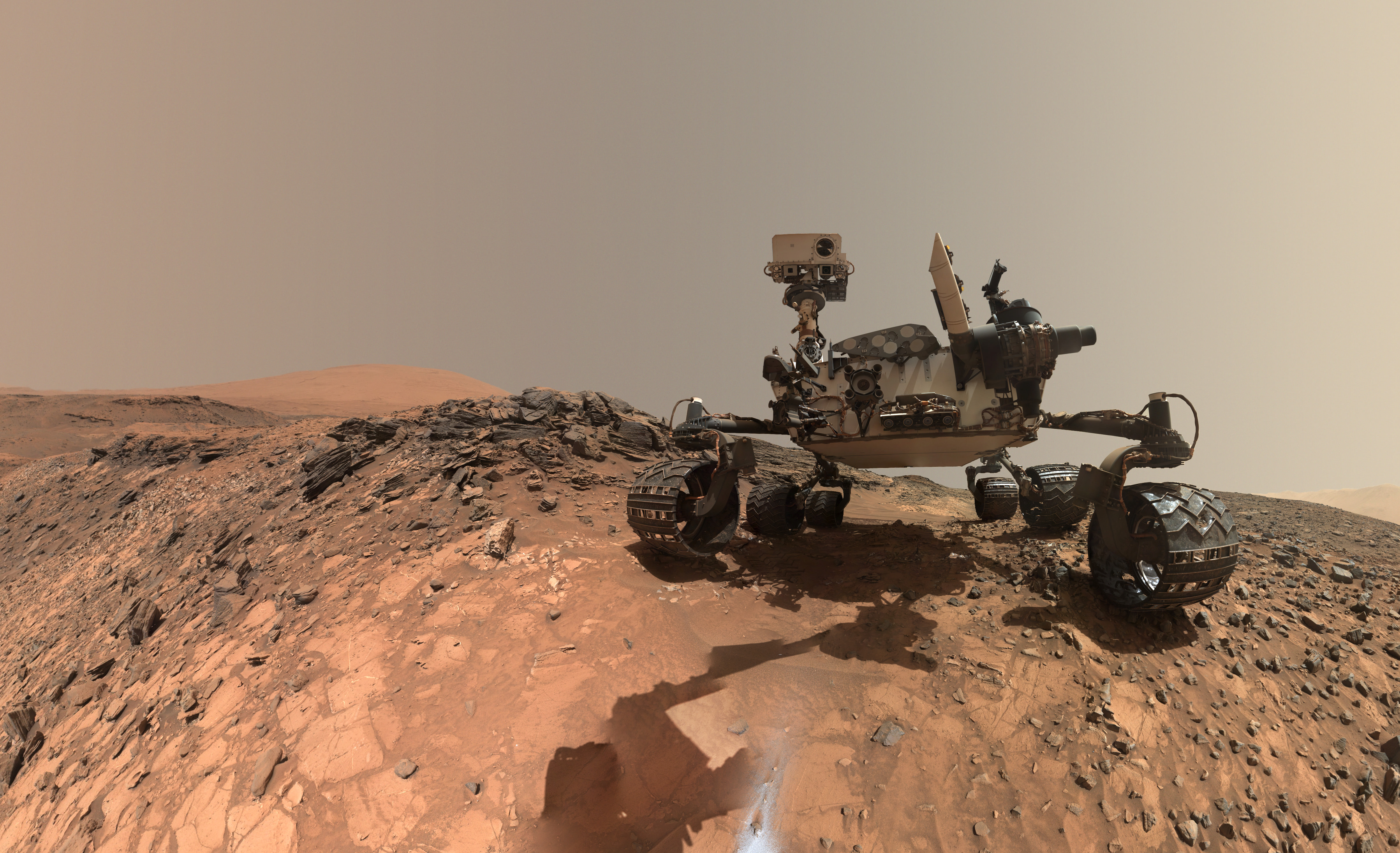
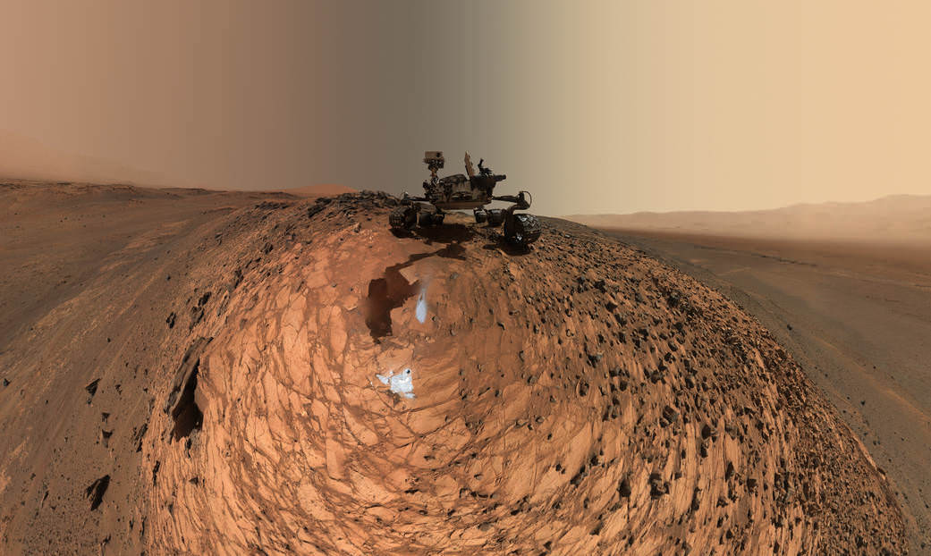
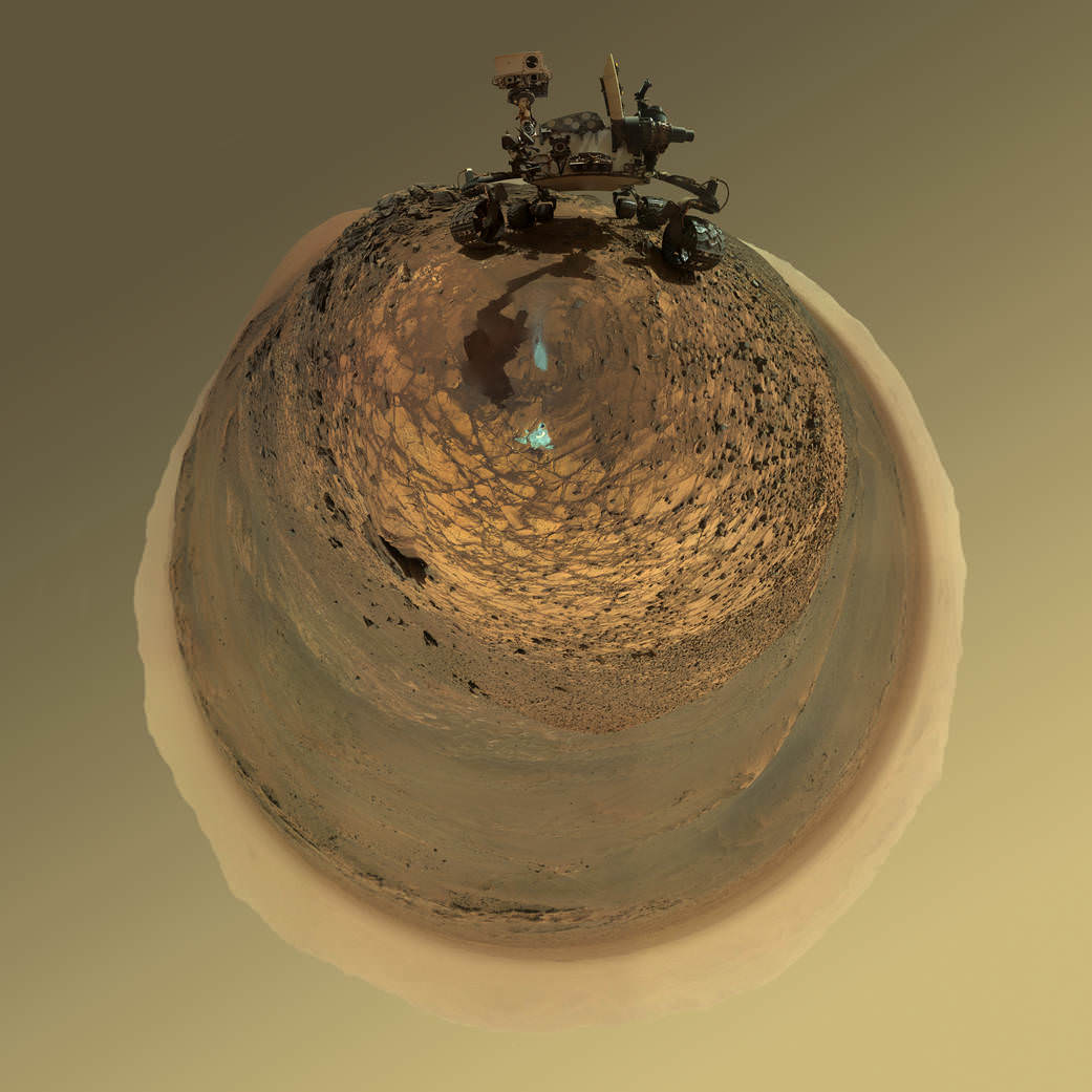
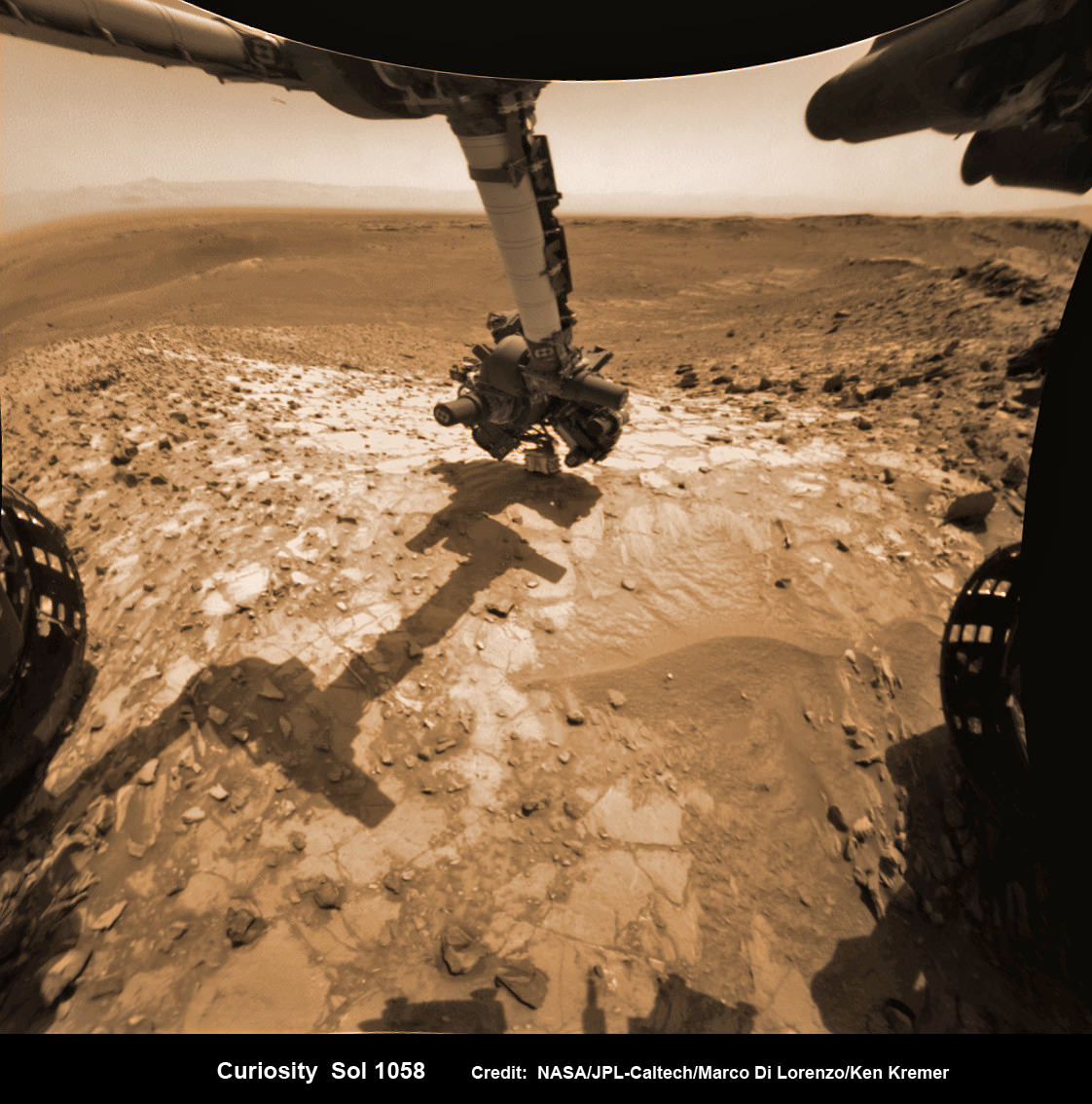
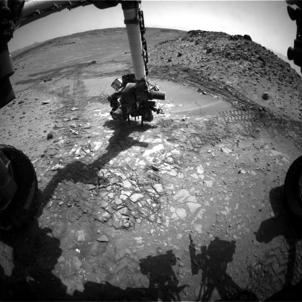
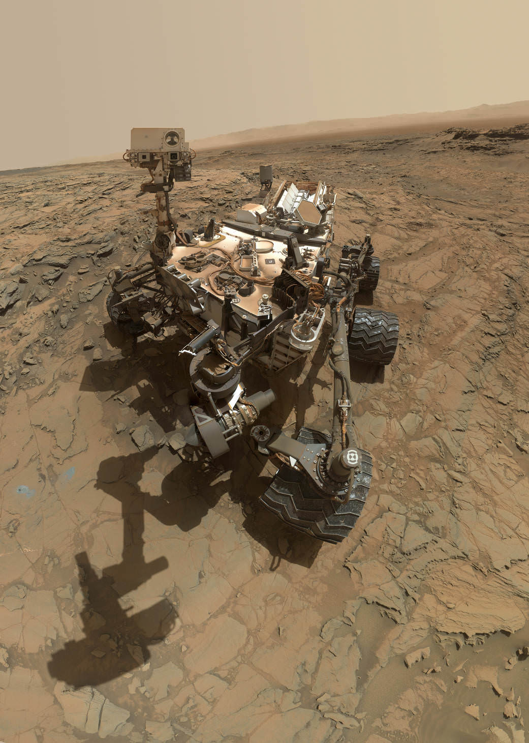
This self-portrait of NASA’s Curiosity Mars rover shows the vehicle at the “Big Sky” site, where its drill collected the mission’s fifth taste of Mount Sharp, at lower left corner. The scene combines images taken by the Mars Hand Lens Imager (MAHLI) camera on Sol 1126 (Oct. 6, 2015). Credit: NASA/JPL-Caltech/MSSS
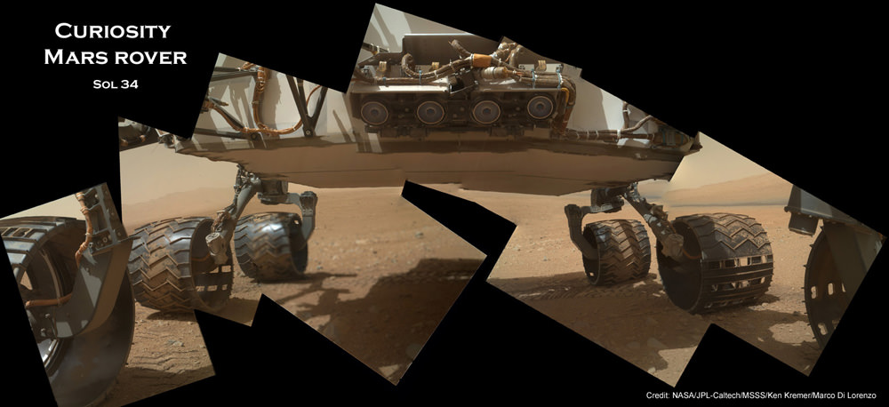
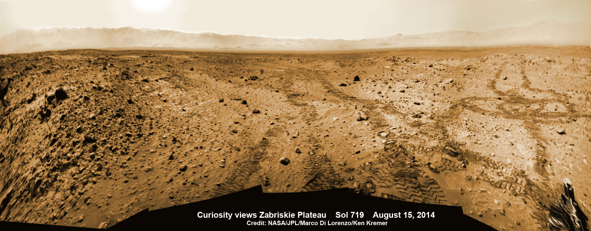
See below navcam drilling photo mosaic at Big Sky[/caption]

NASA’s Curiosity rover has managed to snap another gorgeous selfie while she was hard at work diligently completing her newest Martian sample drilling campaign – at the ‘Big Sky’ site at the base of Mount Sharp, the humongous mountain dominating the center of the mission’s Gale Crater landing site – which the science team just confirmed was home to a life bolstering ancient lake based on earlier sample analyses.

And the team is already actively planning for the car sized robots next drill campaign in the next few sols, or Martian days!

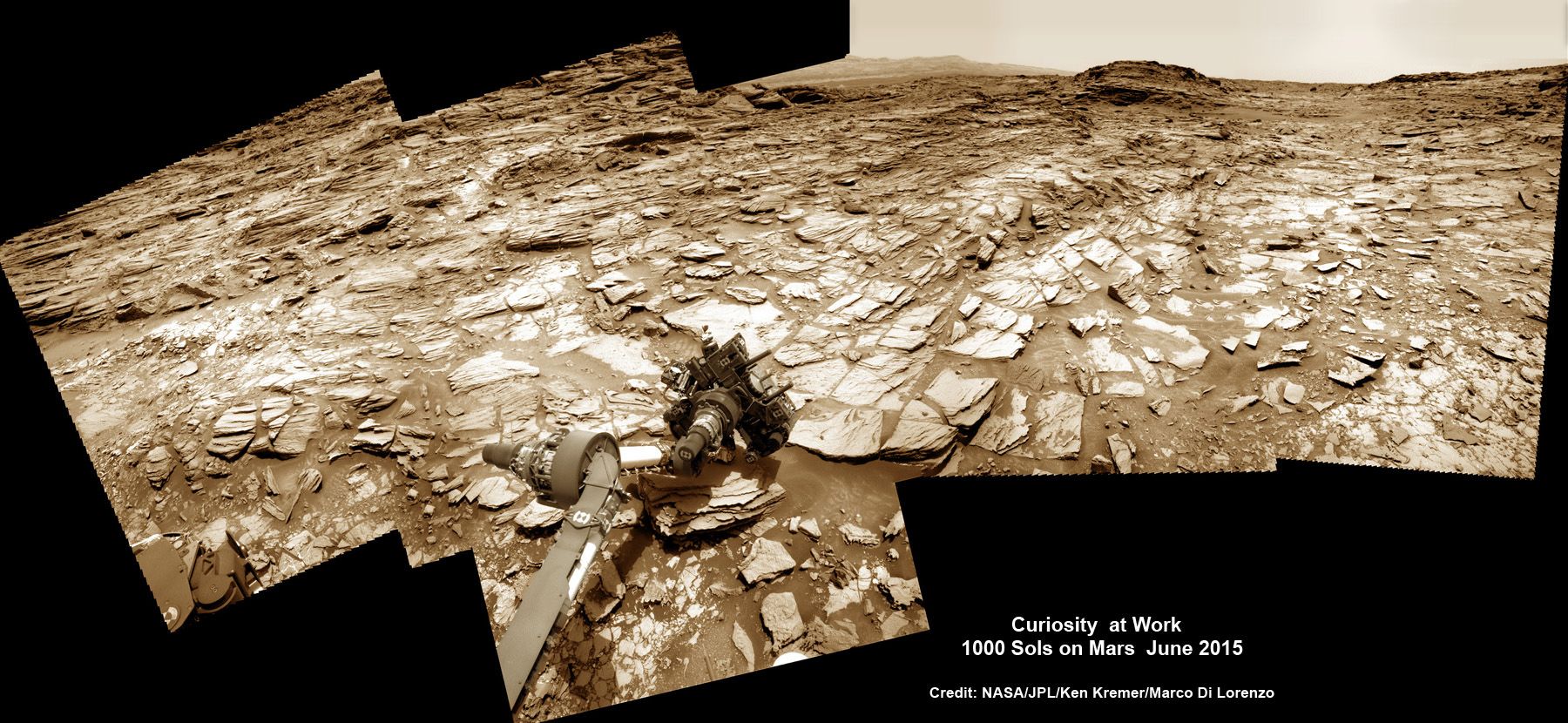
Overall ‘Big Sky’ marks Curiosity’s fifth ‘taste’ of Mount Sharp – since arriving at the mountain base one year ago – and eighth drilling operation since the nail biting Martian touchdown in August 2012.

NASA’s newly published self-portrait was stitched from dozens of images taken at Big Sky last week on Oct. 6, 2015, or Sol 1126, by the high resolution Mars Hand Lens Imager (MAHLI) color camera at the end of the rover’s 7 foot long robotic arm. The view is centered toward the west-northwest.

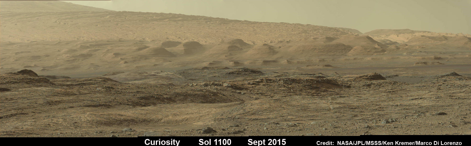
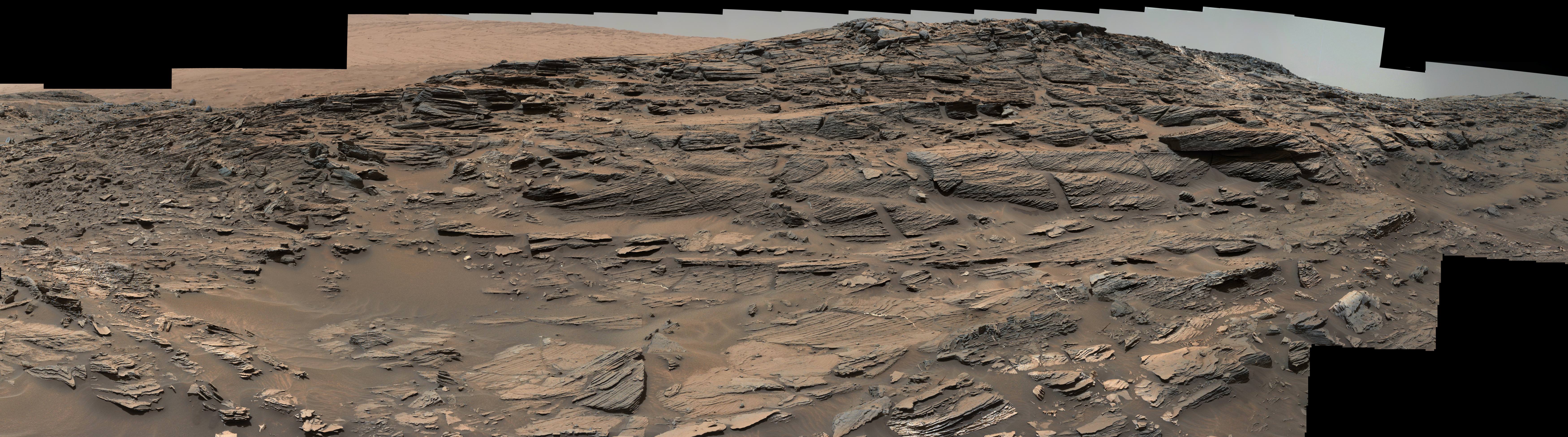
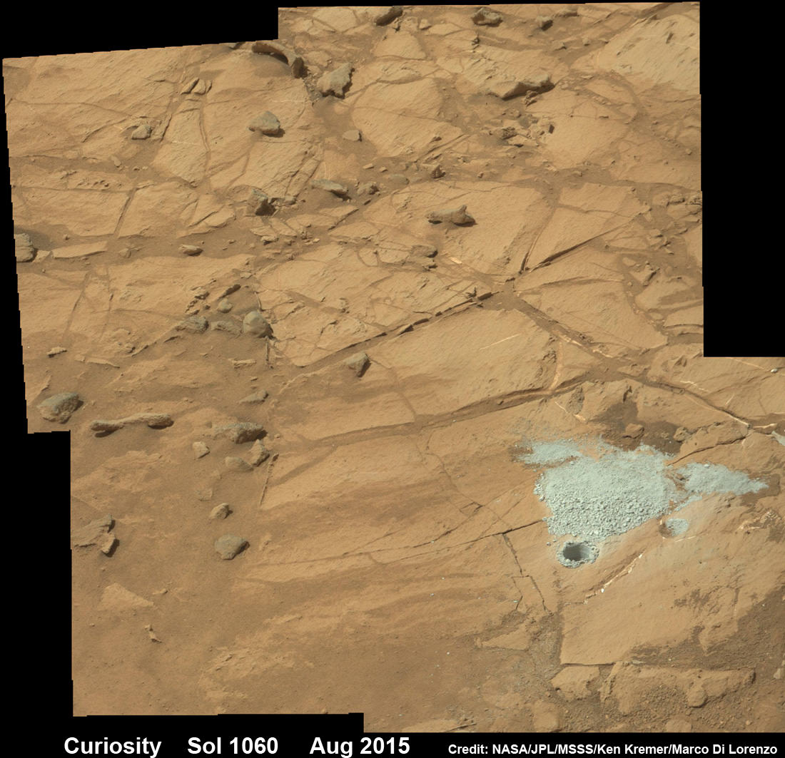
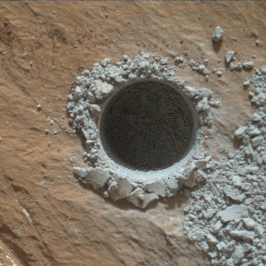
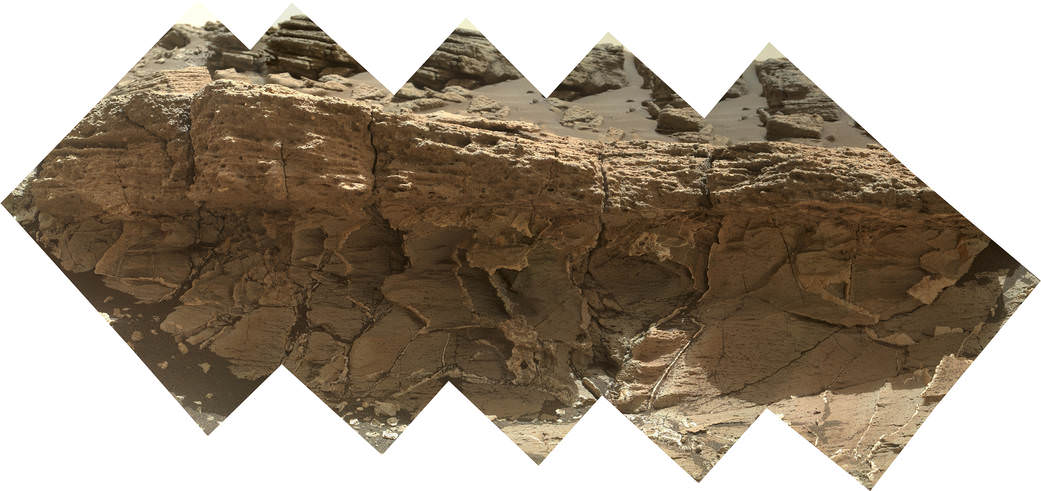
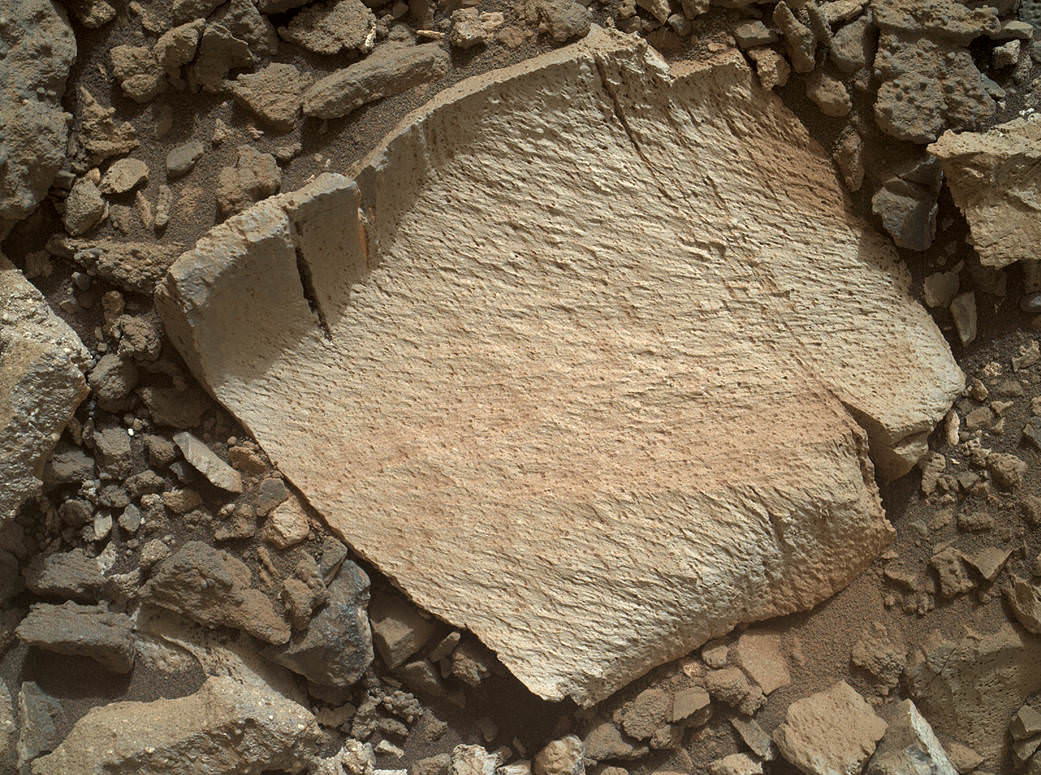
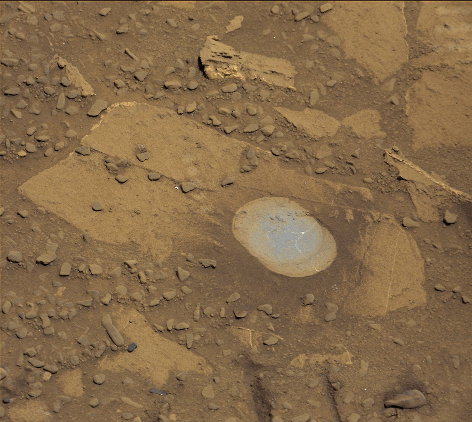
At Big Sky, the Curiosity Mars Science Laboratory (MSL) bored into an area of cross-bedded sandstone rock in the Stimson geological unit on Sept. 29, or Sol 1119. Stimson is located on the lower slopes of Mount Sharp inside Gale Crater.

NASA Curiosity rover reaches out with robotic arm to drill into cross-bedded sandstone rock at ‘Big Sky’ target on Sol 1119, Sept. 29, 2015, in this photo mosaic stitched from navcam  camera raw images and colorized.  Big Sky is located in the Stimson unit on the lower slopes of Mount Sharp inside Gale Crater.  Credit: NASA/JPL/Ken Kremer/kenkremer.com/Marco Di Lorenzo
NASA Curiosity rover reaches out with robotic arm to drill into cross-bedded sandstone rock at ‘Big Sky’ target on Sol 1119, Sept. 29, 2015, in this photo mosaic stitched from navcam camera raw images and colorized. Big Sky is located in the Stimson unit on the lower slopes of Mount Sharp inside Gale Crater. Credit: NASA/JPL/Ken Kremer/kenkremer.com/Marco Di Lorenzo

“Success! Our drill at “Big Sky” went perfectly!” wrote Ryan Anderson, a planetary scientist at the USGS Astrogeology Science Center and a member of the Curiosity ChemCam team.

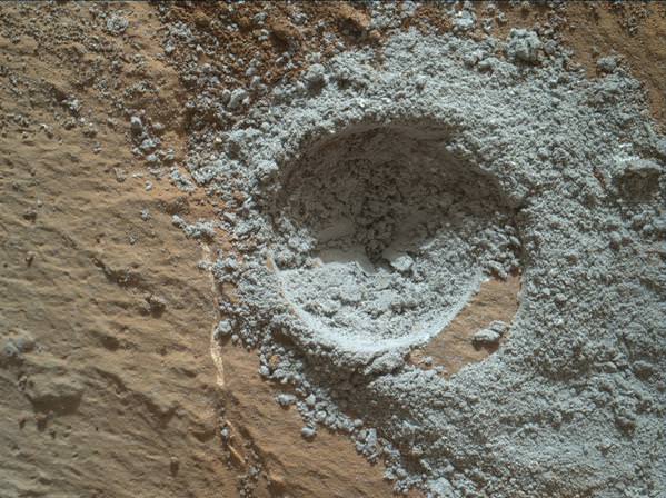
The drill hole is seen at the lower left corner of the MAHLI camera selfie and appears grey along with grey colored tailing – in sharp contrast to the rust red surface. The hole itself is 0.63 inch (1.6 centimeters) in diameter.

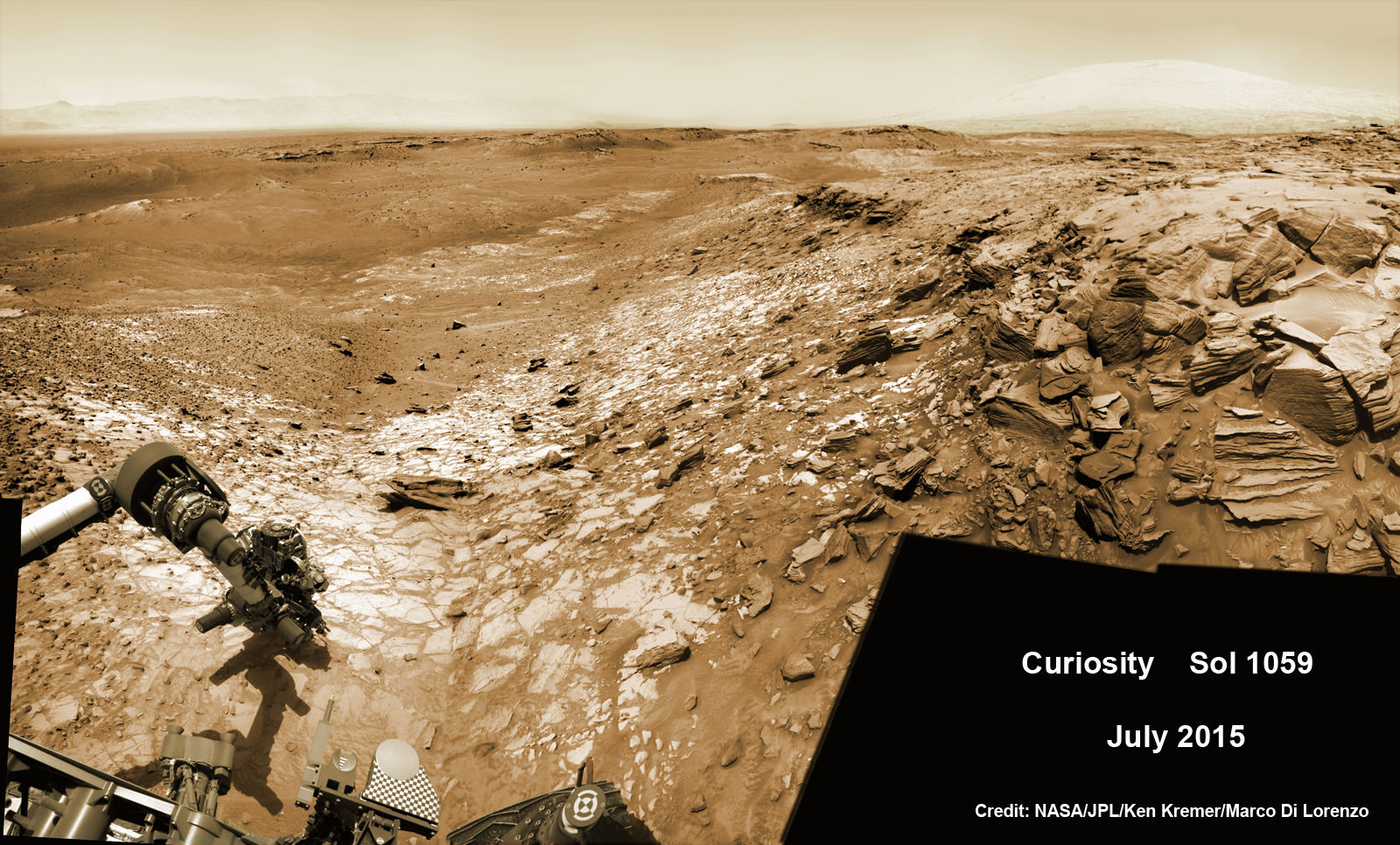
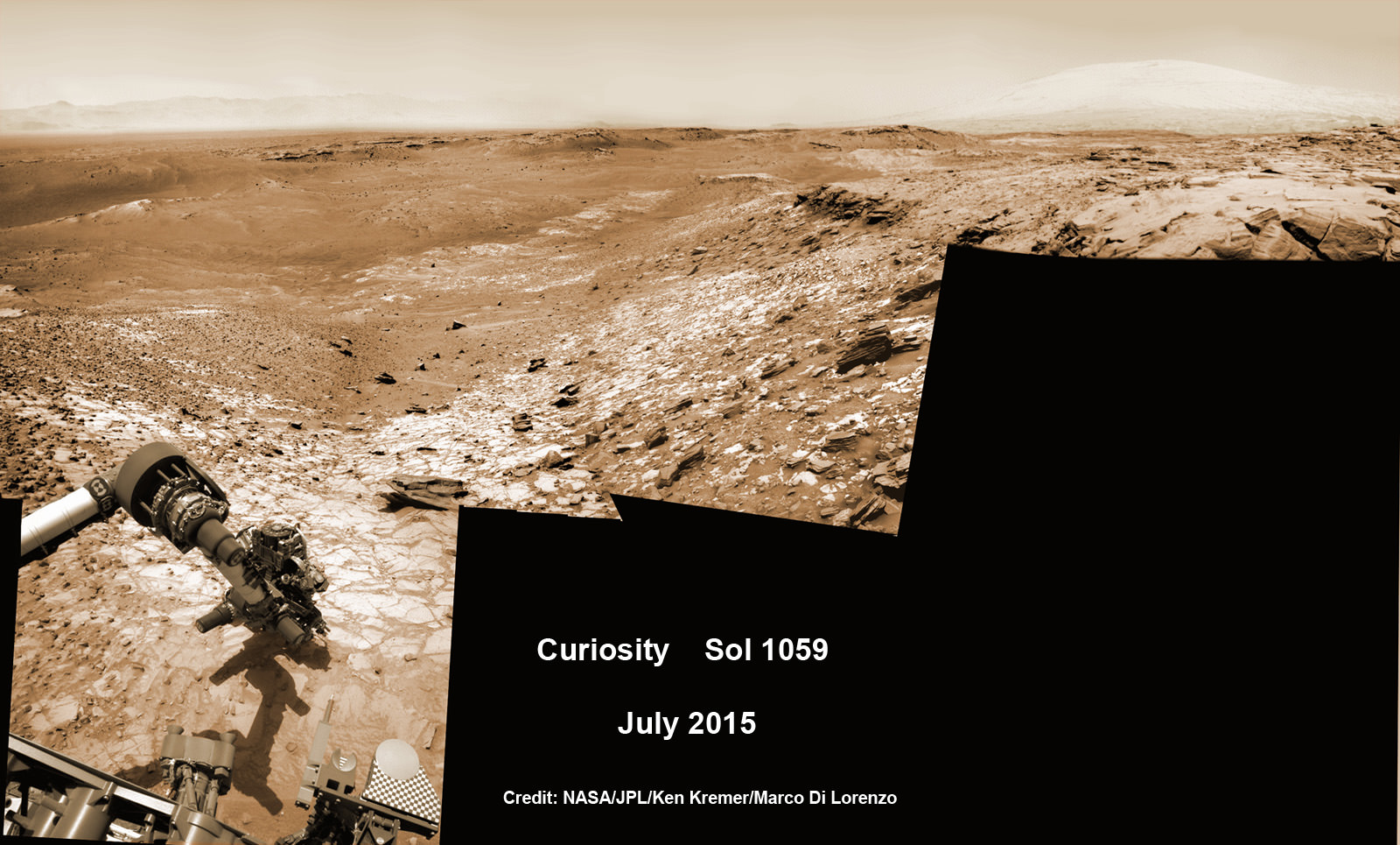
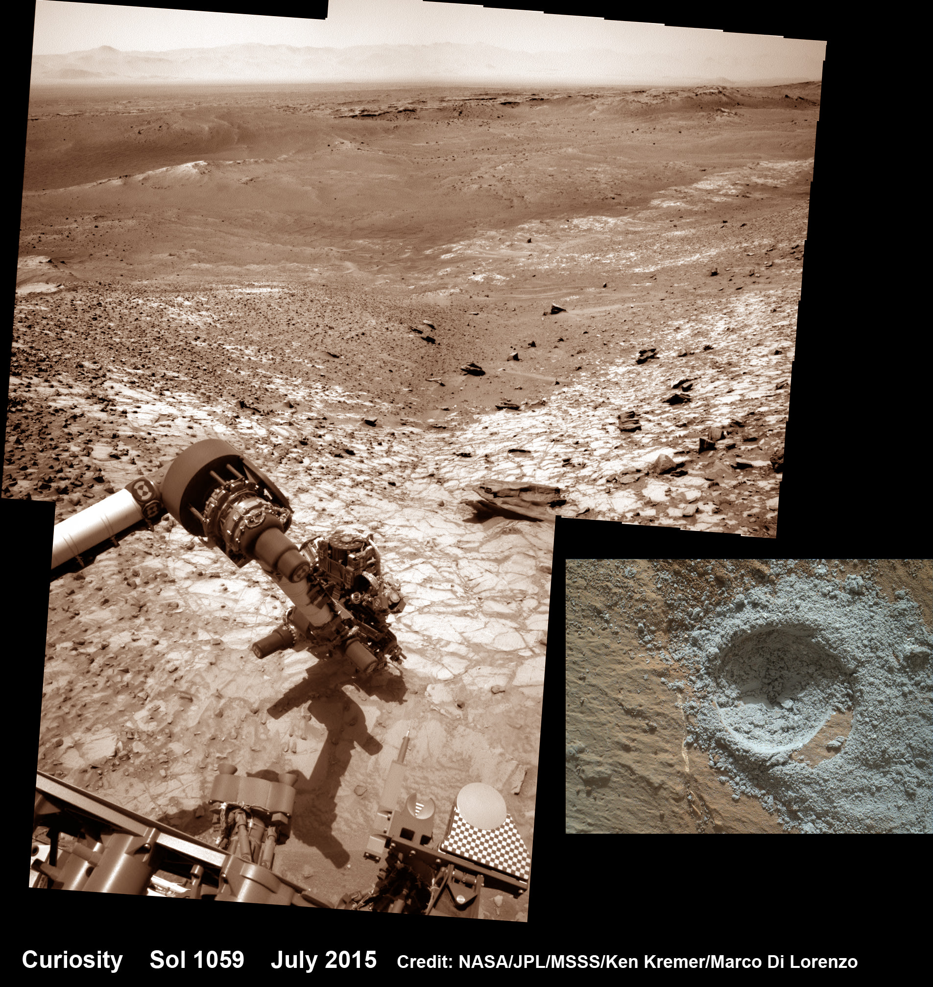
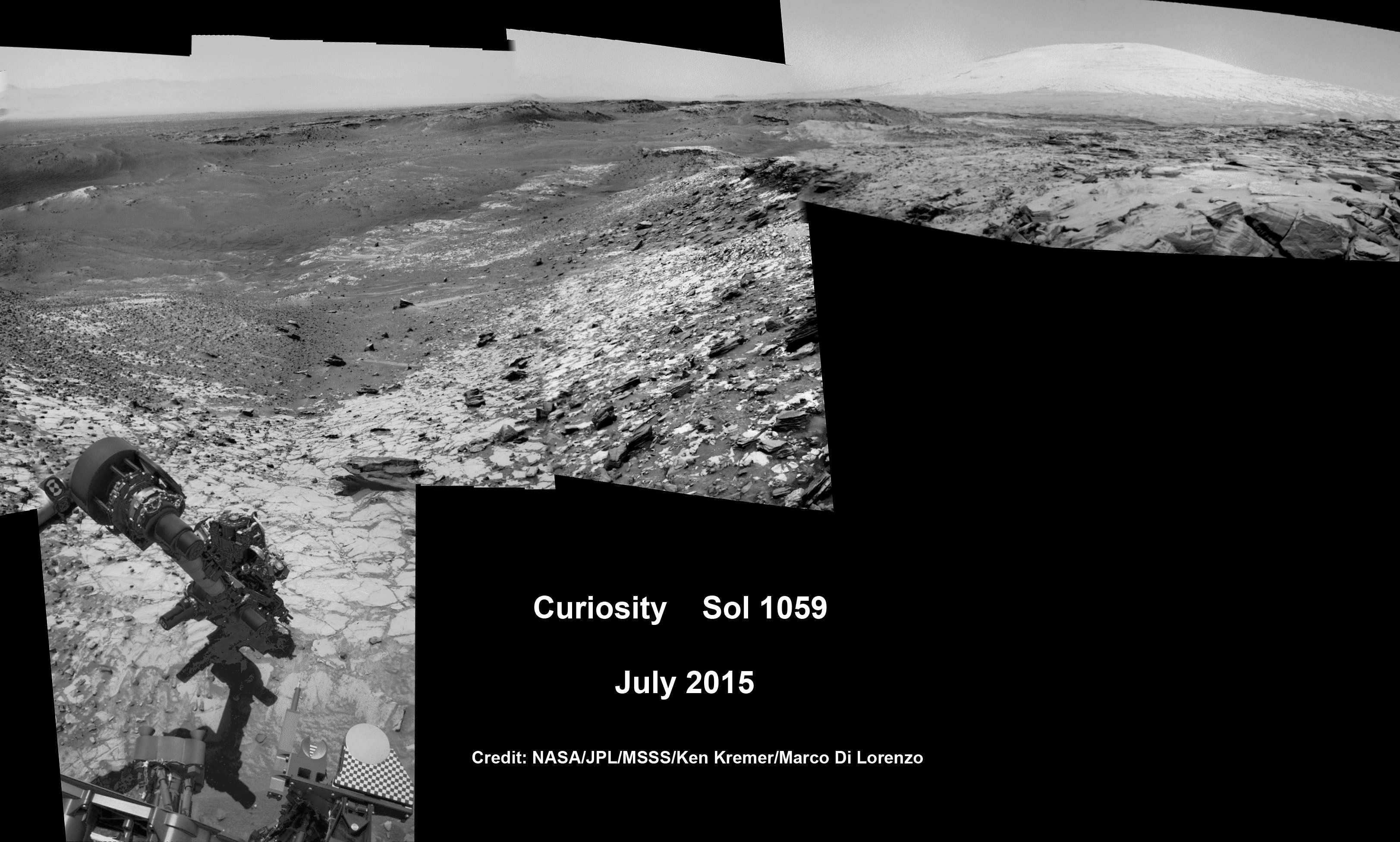
Another panoramic view of the ‘Big Sky’ location shot from the rover’s eye perspective with the mast mounted Navcam camera, is shown in our photo mosaic view herein and created by the image processing team of Ken Kremer and Marco Di Lorenzo. The navcam mosaic was stitched from raw images taken up to Sol 1119 and colorized.

“With Big Sky, we found the ordinary sandstone rock we were looking for,” said Curiosity Project Scientist Ashwin Vasavada, in a statement.

The Big Sky drilling operation is part of a coordinated multi-step campaign to examine different types of sandstone rocks to provide geologic context.

“It also happens to be relatively near sandstone that looks as though it has been altered by fluids — likely groundwater with other dissolved chemicals. We are hoping to drill that rock next, compare the results, and understand what changes have taken place.”

Per normal operating procedures, the Big Sky sample was collected for analysis of the Martian rock’s ingredients in the rover’s two onboard laboratories – the Chemistry and Mineralogy X-Ray diffractometer (CheMin) and the Sample Analysis at Mars (SAM) instrument suite.

“We are all eagerly looking forward to the CheMin results from Big Sky to compare with our previous results from “Buckskin”! noted Anderson.

Curiosity extends robotic arm and conducts sample drilling at “Buckskin” rock target at bright toned “Lion” outcrop at the base of Mount Sharp on Mars, seen at right.   Gale Crater eroded rim seen in the distant background at left, in this composite multisol mosaic of navcam raw images taken to Sol 1059, July 30, 2015.  Navcam camera raw images stitched and colorized. Inset: MAHLI color camera up close image of full depth drill hole at “Buckskin” rock target on Sol 1060.  Credit:  NASA/JPL-Caltech/MSSS/Ken Kremer/kenkremer.com/Marco Di Lorenzo
Curiosity extends robotic arm and conducts sample drilling at “Buckskin” rock target at bright toned “Lion” outcrop at the base of Mount Sharp on Mars, seen at right. Gale Crater eroded rim seen in the distant background at left, in this composite multisol mosaic of navcam raw images taken to Sol 1059, July 30, 2015. Navcam camera raw images stitched and colorized. Inset: MAHLI color camera up close image of full depth drill hole at “Buckskin” rock target on Sol 1060. Credit: NASA/JPL-Caltech/MSSS/Ken Kremer/kenkremer.com/Marco Di Lorenzo

This past weekend, Curiosity successfully fed pulverized and sieved samples of Big Sky to the inlet ports for both CheMin and SAM on the rover deck.

“The SAM analysis of the Big Sky drill sample went well and there is no need for another analysis, so the rest of the sample will be dumped out of CHIMRA on Sol 1132,” said Ken Herkenhoff, Research Geologist at the USGS Astrogeology Science Center and an MSL science team member, in a mission update.

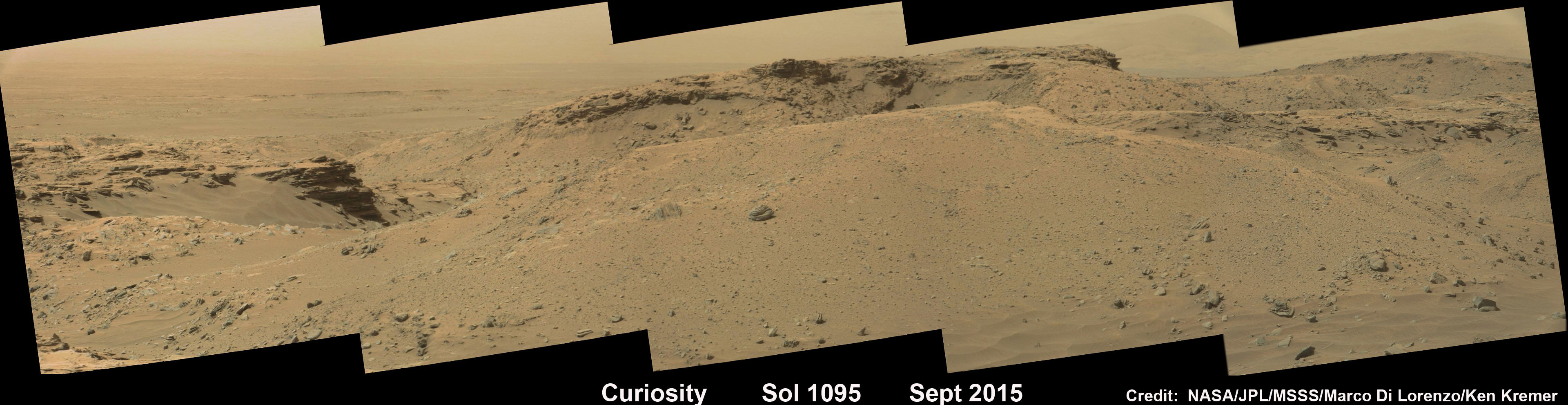
Concurrently the team is hard at work readying the rover for the next drill campaign within days, likely at a target dubbed “Greenhorn.”

So the six wheeled rover drove about seven meters to get within range of Greenhorn.

With the sample deliveries accomplished, attention shifted to the next drilling campaign.

Today, Wednesday, Oct. 14, or Sol 1133, Curiosity was commanded “to dump the “Big Sky” sample and “thwack” CHIMRA (the Collection and Handling for in-Situ Martian Rock Analysis) to clean out any remnants of the sample,” wrote Lauren Edgar, a Research Geologist at the USGS Astrogeology Science Center and a member of MSL science team, in a mission update.

The ChemCam and Mastcam instruments are simultaneously making observations of the “Greenhorn” and “Gallatin Pass” targets “to assess chemical variations across a fracture.”

This Martian "postcard" comes after Mars Curiosity drilled its eighth hole on the Red Planet.  This composite image looking toward the higher regions of Mount Sharp was taken on September 9, 2015, by NASA's Curiosity rover. In the foreground -- about 2 miles (3 kilometers) from the rover -- is a long ridge teeming with hematite, an iron oxide.  Credits: NASA/JPL-Caltech/MSSS
This Martian “postcard” comes after Mars Curiosity drilled its eighth hole on the Red Planet. This composite image looking toward the higher regions of Mount Sharp was taken on September 9, 2015, by NASA’s Curiosity rover. In the foreground — about 2 miles (3 kilometers) from the rover — is a long ridge teeming with hematite, an iron oxide. Credits: NASA/JPL-Caltech/MSSS

Curiosity has already accomplished her primary objective of discovering a habitable zone on the Red Planet – at the Yellowknife Bay area – that contains the minerals necessary to support microbial life in the ancient past when Mars was far wetter and warmer billions of years ago.

As of today, Sol 1133, October 14, 2015, she has driven some 6.9 miles (11.1 kilometers) kilometers and taken over 274,600 amazing images.

Stay tuned here for Ken’s continuing Earth and planetary science and human spaceflight news.

Ken Kremer

Curiosity looks toward fabulous canyons and buttes at the base of Mount Sharp from the Stimson sand dunes on Mars on Sol 1100, Sept. 10  2015 in this photo mosaic stitched from Mastcam color camera raw images.  Credit: NASA/JPL/MSSS/Ken Kremer/kenkremer.com/Marco Di Lorenzo
Curiosity looks toward fabulous canyons and buttes at the base of Mount Sharp from the Stimson sand dunes on Mars on Sol 1100, Sept. 10 2015 in this photo mosaic stitched from Mastcam color camera raw images. Credit: NASA/JPL/MSSS/Ken Kremer/kenkremer.com/Marco Di Lorenzo

Weekly Space Hangout – Oct 2, 2015: Water on Mars, Blood Moon Eclipses, and More Pluto!

Host: Fraser Cain (@fcain)

Guests:

Morgan Rehnberg (cosmicchatter.org / @MorganRehnberg )
Pamela Gay (cosmoquest.org / @cosmoquestx / @starstryder)
Kimberly Cartier (@AstroKimCartier )
Brian Koberlein (@briankoberlein / briankoberlein.com)
Alessondra Springmann (@sondy)
Continue reading “Weekly Space Hangout – Oct 2, 2015: Water on Mars, Blood Moon Eclipses, and More Pluto!”

Curiosity Investigates Petrified Martian Sand Dunes, Contemplates Next Drill Campaign

Large-scale crossbedding in the sandstone of this ridge on a lower slope of Mars' Mount Sharp is typical of windblown sand dunes that have petrified. NASA's Curiosity Mars rover used its Mastcam to capture this vista on Aug. 27, 2015, Sol 1087. Similarly textured sandstone is common in the U.S. Southwest. Credits: NASA/JPL-Caltech/MSSS

Large-scale crossbedding in the sandstone of this ridge on a lower slope of Mars’ Mount Sharp is typical of windblown sand dunes that have petrified. NASA’s Curiosity Mars rover used its Mastcam to capture this vista on Aug. 27, 2015, Sol 1087. Similarly textured sandstone is common in the U.S. Southwest. Credits: NASA/JPL-Caltech/MSSS
See Sol 1100 mosaic below [/caption]

NASA’s SUV-sized Curiosity rover has arrived at a beautiful Martian vista displaying a huge deposit of magnificently petrified sand dunes that look remarkably like some commonly found on Earth and native to the deserts of the U.S. Southwest.

The dunes are keenly fascinating to Red Planet researchers as the NASA robot celebrates 1100 fabulous Sols of exploration and discovery on Mars and contemplates plans for the next drill campaign later this month. See dune mosaic above and our Sol 1100 mosaic below.

The petrified sand dunes were discovered amongst an area of dark sandstone along a ridge at the lower slope of Mars’ Mount Sharp. They are now being explored in detail by the six wheeled rover in a geologic feature dubbed the Stimson unit.

“The team is considering where to drill next within the Stimson sandstone and we are looking for the best light toned areas to check for mineralogical signs of water-rock reaction,” says John Bridges, rover team member from the University of Leicester, England, in the latest mission update from today, September 12, 2015.

Curiosity looks toward fabulous canyons and buttes at the base of Mount Sharp from the Stimson sand dunes on Mars on Sol 1100, Sept. 10  2015 in this photo mosaic stitched from Mastcam color camera raw images.  Credit: NASA/JPL/MSSS/Ken Kremer/kenkremer.com/Marco Di Lorenzo
Curiosity looks toward fabulous canyons and buttes at the base of Mount Sharp from the Stimson sand dunes on Mars on Sol 1100, Sept. 10 2015 in this photo mosaic stitched from Mastcam color camera raw images. Credit: NASA/JPL/MSSS/Ken Kremer/kenkremer.com/Marco Di Lorenzo

Curiosity also discovered large-scale crossbedding in the sandstone that were formed by the action of Martian winds.

“This sandstone outcrop — part of a geological layer that Curiosity’s science team calls the Stimson unit — has a structure called crossbedding on a large scale that the team has interpreted as deposits of sand dunes formed by wind,” according to the rover team.

So Curiosity was commanded by her handlers back on Earth to capture an array of high resolution imagery as part of detailed investigation of the area for up close and contact science.

Dozens of images were taken with the pair of high resolution Mastcam color cameras on the robots mast and combined into the panoramic scene show above and another shown below with a scalebar the length of a tall human, 6.6 feet or 200 centimeters.

Large-scale crossbedding in the sandstone of this ridge on a lower slope of Mars' Mount Sharp is typical of windblown sand dunes that have petrified. NASA's Curiosity Mars rover used its Mastcam to capture this vista on Aug. 27, 2015. Similarly textured sandstone is common in the U.S. Southwest.  Credits: NASA/JPL-Caltech/MSSS
Large-scale crossbedding in the sandstone of this ridge on a lower slope of Mars’ Mount Sharp is typical of windblown sand dunes that have petrified. NASA’s Curiosity Mars rover used its Mastcam to capture this vista on Aug. 27, 2015. Similarly textured sandstone is common in the U.S. Southwest. Credits: NASA/JPL-Caltech/MSSS

The images were taken on Aug. 27, 2015, corresponding to Sol 1087 of the rover’s work on Mars, using both the 34 millimeter-focal-length lens and the 100 mm millimeter-focal-length telephoto Mastcam camera lenses that function as Curiosity’s left and right eyes.

The panorama spans the Martian terrain looking from the east, at left, to the south-southwest at right.

“Some of the dark sandstone in the area …. shows texture and inclined bedding structures characteristic of deposits that formed as sand dunes, then were cemented into rock” say officials.

“Sets of bedding laminations lie at angles to each other.”

Since taking the panorama in late August, the team has driven Curiosity around the area to collect more measurements with her state of the art science instruments.

Later this month, Curiosity will drill into an outcrop at the Stimson unit sandstone for collection and feed it for analysis into the pair of on board chemistry labs – SAM and CheMin- located inside the rover’s belly.

Curiosity already carried out initial contact science in the area by extending the robotic arm to rock targets for investigation with the arm mounted instruments, including the MAHLI camera and APXS spectrometer.

Curiosity “investigated an outcrop of the Stimson unit … and conducted successful contact science,” says Lauren Edgar, Research Geologist at the USGS Astrogeology Science Center and an MSL science team member, in a mission update.

Scientists will select the Stimson drill target soon.

Curiosity rover explores around the Stimson unit at the base of Mount Sharp on Mars on Sol 1095, Sept. 5, 2015 in this photo mosaic stitched from Mastcam color camera raw images.  Credit: NASA/JPL/MSSS/Marco Di Lorenzo/Ken Kremer/kenkremer.com
Curiosity rover explores around the Stimson unit at the base of Mount Sharp on Mars on Sol 1095, Sept. 5, 2015 in this photo mosaic stitched from Mastcam color camera raw images. Credit: NASA/JPL/MSSS/Marco Di Lorenzo/Ken Kremer/kenkremer.com

Why explore outcrops at Stimson?

“The Stimson unit overlies a layer of mudstone that was deposited in a lake environment. Curiosity has been examining successively higher and younger layers of Mount Sharp, starting with the mudstone at the mountain’s base, for evidence about changes in the area’s ancient environment.”

Curiosity’s prior drill campaign was recently conducted at the “Buckskin” outcrop target in early August 2015. Buckskin was very notable for being the first high silica rock drilling target of the mission.

Curiosity extends robotic arm and conducts sample drilling at “Buckskin” rock target at bright toned “Lion” outcrop at the base of Mount Sharp on Mars, seen at right.   Gale Crater eroded rim seen in the distant background at left, in this composite multisol mosaic of navcam raw images taken to Sol 1059, July 30, 2015.  Navcam camera raw images stitched and colorized. Inset: MAHLI color camera up close image of full depth drill hole at “Buckskin” rock target on Sol 1060.  Credit:  NASA/JPL-Caltech/MSSS/Ken Kremer/kenkremer.com/Marco Di Lorenzo
Curiosity extends robotic arm and conducts sample drilling at “Buckskin” rock target at bright toned “Lion” outcrop at the base of Mount Sharp on Mars, seen at right. Gale Crater eroded rim seen in the distant background at left, in this composite multisol mosaic of navcam raw images taken to Sol 1059, July 30, 2015. Navcam camera raw images stitched and colorized. Inset: MAHLI color camera up close image of full depth drill hole at “Buckskin” rock target on Sol 1060. Credit: NASA/JPL-Caltech/MSSS/Ken Kremer/kenkremer.com/Marco Di Lorenzo

Stimson and Buckskin sit at the base of Mount Sharp, a huge layered mountain that dominates the center of the 96 mile-wide (154 kilometers-wide) Gale Crater landing site.

Exploring the sedimentary layers of Mount Sharp, which towers 3.4 miles (5.5 kilometers) into the Martian sky, is the primary destination and goal of the rovers long term scientific expedition on the Red Planet.

Curiosity recently celebrated 1000 Sols of exploration on Mars on May 31, 2015 – detailed here with our Sol 1000 mosaic by Marco Di Lorenzo and Ken Kremer also featured at Astronomy Picture of the Day on June 13, 2015.

As of today, Sol 1102, September 12, 2015, she has driven some 6.9 miles (11.1 kilometers) kilometers and taken over 268,000 amazing images.

Curiosity has already accomplished her primary objective of discovering a habitable zone on the Red Planet – at the Yellowknife Bay area – that contains the minerals necessary to support microbial life in the ancient past when Mars was far wetter and warmer billions of years ago.

Curiosity rover scans toward south east around Marias Pass area at the base of Mount Sharp on Mars on Sol 1074, Aug. 14, 2015 in this photo mosaic stitched from Mastcam color camera raw images.  Credit: NASA/JPL/MSSS/Marco Di Lorenzo/Ken Kremer/kenkremer.com
Curiosity rover scans toward south east around Marias Pass area at the base of Mount Sharp on Mars on Sol 1074, Aug. 14, 2015 in this photo mosaic stitched from Mastcam color camera raw images. Credit: NASA/JPL/MSSS/Marco Di Lorenzo/Ken Kremer/kenkremer.com

Stay tuned here for Ken’s continuing Earth and planetary science and human spaceflight news.

Ken Kremer

Curiosity Snaps Stunning One of a Kind Belly Selfie At Buckskin Mountain Base Drill Site

This low-angle self-portrait of NASA's Curiosity Mars rover shows the vehicle at the site from which it reached down to drill into a rock target called "Buckskin." The MAHLI camera on Curiosity's robotic arm took multiple images on Aug. 5, 2015, that were stitched together into this selfie. Credits: NASA/JPL-Caltech/MSSS

This low-angle self-portrait of NASA’s Curiosity Mars rover shows the vehicle at the site from which it reached down to drill into a rock target called “Buckskin.” The MAHLI camera on Curiosity’s robotic arm took multiple images on Aug. 5, 2015, that were stitched together into this selfie. Credits: NASA/JPL-Caltech/MSSS
More selfie and drilling mosaics below[/caption]

NASA’s Curiosity rover has snapped a stunningly beautiful, one of a kind ‘belly selfie’ amidst the painstaking ‘Buckskin’ drill campaign at the Martian mountain base marking the third anniversary since her touchdown on the Red Planet.

The unique self portrait was taken from a low-angle for the first time and shows the six wheeled rover at work collecting her seventh drilled sample at the ‘Buckskin’ rock target earlier this month in the “Marias Pass” area of lower Mount Sharp.

‘Buckskin’ is also unique in a fabulously scientifically way because the rover discovered a new type of Martian rock that’s surprisingly rich in silica – and unlike any other targets found before.

The low camera angle is what enables the awesome Buckskin belly selfie. It’s a distinctively dramatic view and actually stitched from 92 images captured by the Mars Hand Lens Imager (MAHLI) on Aug. 5, 2015, or Sol 1065 of the mission.

The high resolution MAHLI color camera is located on the end of the 7 foot-long (2.1 meter-long) robotic arm.

This version of a self-portrait of NASA's Curiosity Mars rover at a drilling site called "Buckskin" is presented as a stereographic projection, which shows the horizon as a circle. The MAHLI camera on Curiosity's robotic arm took dozens of component images for this selfie on Aug. 5, 2015.  Credits: NASA/JPL-Caltech/MSSS
This version of a self-portrait of NASA’s Curiosity Mars rover at a drilling site called “Buckskin” is presented as a stereographic projection, which shows the horizon as a circle. The MAHLI camera on Curiosity’s robotic arm took dozens of component images for this selfie on Aug. 5, 2015. Credits: NASA/JPL-Caltech/MSSS

Indeed the car-sized rover has taken spectacular selfies several times before during her three year long trek across the Martian surface, since the August 2012 landing inside Mars’ Gale Crater. But for those past selfies the MAHLI camera was hoisted higher to give the perspective of looking somewhat downward and showing the rovers top deck and trio of sample inlet ports.

In this case, the rover team specifically commanded Curiosity to position “the camera lower in relation to the rover body than for any previous full self-portrait of Curiosity,” said NASA officials.

Two patches of gray colored powdered rock material drilled from Buckskin are visible in the selfie scene, in front of the rover.

“The patch closer to the rover is where the sample-handling mechanism on Curiosity’s robotic arm dumped collected material that did not pass through a sieve in the mechanism. Sieved sample material was delivered to laboratory instruments inside the rover. The patch farther in front of the rover, roughly triangular in shape, shows where fresh tailings spread downhill from the drilling process.”

Prior selfies were taken at the “Rocknest” (http://photojournal.jpl.nasa.gov/catalog/PIA16468), “John Klein” (http://photojournal.jpl.nasa.gov/catalog/PIA16937), “Windjana” (http://photojournal.jpl.nasa.gov/catalog/PIA18390) and “Mojave” drill sites.

Basically in the Sol 1065 belly selfie at “Buckskin” we see the underbelly of the rover and all six wheels along with a complete self portrait.

This version of a self-portrait of NASA's Curiosity Mars rover at a drilling site called "Buckskin" is presented as a stereographic projection, which shows the horizon as a circle. The MAHLI camera on Curiosity's robotic arm took dozens of component images for this selfie on Aug. 5, 2015.  Credits: NASA/JPL-Caltech/MSSS
This version of a self-portrait of NASA’s Curiosity Mars rover at a drilling site called “Buckskin” is presented as a stereographic projection, which shows the horizon as a circle. The MAHLI camera on Curiosity’s robotic arm took dozens of component images for this selfie on Aug. 5, 2015. Credits: NASA/JPL-Caltech/MSSS

On several prior occasions, MAHLI was used to image just the underbelly and wheels to aid in inspecting the wheels to look for signs of damage inflicted by sharp-edged Martian rocks poking holes in the aluminum wheels.

Underbelly view of Curiosity rover and wheels on Sol 34.  Credit: NASA/JPL/MSSS/Ken Kremer/Marco Di Lorenzo
Underbelly view of Curiosity rover and wheels on Sol 34, Sept. 9, 2012. Credit: NASA/JPL/MSSS/Ken Kremer/Marco Di Lorenzo

Each wheel measures 20 inches (50 centimeters) in diameter and about 16 inches (40 centimeters) wide. And the MAHLI monitoring images have shown the effects of increasing wear and tear that ultimately forced the rover drivers to alter Curiosity’s driving route on the crater floor in favor of smoother and less rocky terrain imparting less damage to the critical wheels.

If you take a close look at the new selfie up top, you’ll see a small rock stuck onto Curiosity’s left middle wheel (on the right in this head-on view). The rock was seen also in prior wheel monitoring images taken three weeks ago.

“The selfie at Buckskin does not include the rover’s robotic arm beyond a portion of the upper arm held nearly vertical from the shoulder joint. With the wrist motions and turret rotations used in pointing the camera for the component images, the arm was positioned out of the shot in the frames or portions of frames used in this mosaic,” according to officials.

The drilling campaign into “Buckskin” was successfully conducted on Sol 1060 (July 30, 2015) at the bright toned “Lion” outcrop to a full depth of about 2.6 inches (6.5 centimeters) and approximately 1.6 cm (0.63 inch) diameter.

Curiosity extends robotic arm and conducts sample drilling at “Buckskin” rock target at bright toned “Lion” outcrop at the base of Mount Sharp on Mars, seen at right.   Gale Crater eroded rim seen in the distant background at left, in this composite multisol mosaic of navcam raw images taken to Sol 1059, July 30, 2015.  Navcam camera raw images stitched and colorized. Inset: MAHLI color camera up close image of full depth drill hole at “Buckskin” rock target on Sol 1060.  Credit:  NASA/JPL-Caltech/MSSS/Ken Kremer/kenkremer.com/Marco Di Lorenzo
Curiosity extends robotic arm and conducts sample drilling at “Buckskin” rock target at bright toned “Lion” outcrop at the base of Mount Sharp on Mars, seen at right. Gale Crater eroded rim seen in the distant background at left, in this composite multisol mosaic of navcam raw images taken to Sol 1059, July 30, 2015. Navcam camera raw images stitched and colorized. Inset: MAHLI color camera up close image of full depth drill hole at “Buckskin” rock target on Sol 1060. Credit: NASA/JPL-Caltech/MSSS/Ken Kremer/kenkremer.com/Marco Di Lorenzo

You can also see another perspective of the rover at work while reaching out with the robotic arm and drilling into ‘Buckskin’ as illustrated in our mosaics of mastcam and navcam camera raw images created by the image processing team of Ken Kremer and Marco Di Lorenzo.

The main bore hole was drilled next to the initial mini hole test and shows the indicative residue of grey colored tailings from the Martian subsurface seen distributed around the new hole.

Curiosity rover successfully drills into Martian outcrop  at Buckskin rock target at current work site at base of Mount Sharp in August 2015, in this mosaic showing full depth drill hole and initial test hole, with grey colored subsurface tailings and mineral veins on surrounding Red Planet terrain.  This high resolution photo mosaic is a multisol composite of color images taken by the mast mounted Mastcam-100 color camera up to Sol 1060, July 31, 2015.   Credit:  NASA/JPL-Caltech/Ken Kremer/kenkremer.com/Marco Di Lorenzo
Curiosity rover successfully drills into Martian outcrop at Buckskin rock target at current work site at base of Mount Sharp in August 2015, in this mosaic showing full depth drill hole and initial test hole, with grey colored subsurface tailings and mineral veins on surrounding Red Planet terrain. This high resolution photo mosaic is a multisol composite of color images taken by the mast mounted Mastcam-100 color camera up to Sol 1060, July 31, 2015. Credit: NASA/JPL-Caltech/Ken Kremer/kenkremer.com/Marco Di Lorenzo

Curiosity has now moved on from the “Marias Pass” area.

Curiosity recently celebrated 1000 Sols of exploration on Mars on May 31, 2015 – detailed here with our Sol 1000 mosaic also featured at Astronomy Picture of the Day on June 13, 2015.

As of today, Sol 1080, August 20, 2015, she has driven some 6.9 miles (11.1 kilometers) kilometers and taken over 260,000 amazing images.

Curiosity rover scans toward south east around Marias Pass area at the base of Mount Sharp on Mars on Sol 1074, Aug. 14, 2015 in this photo mosaic stitched from Mastcam color camera raw images.  Credit: NASA/JPL/MSSS/Marco Di Lorenzo/Ken Kremer/kenkremer.com
Curiosity rover scans toward south east around Marias Pass area at the base of Mount Sharp on Mars on Sol 1074, Aug. 14, 2015 in this photo mosaic stitched from Mastcam color camera raw images. Credit: NASA/JPL/MSSS/Marco Di Lorenzo/Ken Kremer/kenkremer.com

Curiosity has already accomplished her primary objective of discovering a habitable zone on the Red Planet – at the Yellowknife Bay area – that contains the minerals necessary to support microbial life in the ancient past when Mars was far wetter and warmer billions of years ago.

Stay tuned here for Ken’s continuing Earth and planetary science and human spaceflight news.

Ken Kremer

Indian Mars Orbiter Shoots Spectacular New Images of Sheer Canyon and Curiosity’s Crater

This view over the Ophir Chasma canyon on the Martian surface was taken by the Mars Colour Camera aboard India’s Mars Orbiter Mission (MOM). Ophir Chasma is a canyon in the Coprates quadrangle located at 4° south latitude and 72.5° west longitude. It is part of the Valles Marineris canyon system. Credit: ISRO

India’s space agency has released a spectacular new batch of images taken by everyone’s favorite MOM – the Mars Orbiter Mission – the nation’s first probe ever dispatched to the Red Planet and which achieved orbit nearly a year ago.

The Indian Space Research Organization (ISRO) has published a beautiful gallery of images featuring a steep and stunning Martian canyon and the landing site of NASA’s Curiosity Mars Science Laboratory rover, and more.

The lead image was taken over the Ophir Chasma canyon on the Martian surface by the Mars Colour Camera aboard India’s Mars Orbiter Mission.

Ophir Chasma is a canyon in the Coprates quadrangle located at 4° south latitude and 72.5° west longitude. It is part of the Valles Marineris – the ‘Grand Canyon of Mars’ – and the largest known canyon in the Solar System.

The image was captured on July 19, 2015 from an altitude of 1857 kilometers (1154 miles). It has with a resolution of 96 meters.

The steep walled Ophir Chasma canyon contains many layers and the floors contain large deposits of layered materials, perhaps even sulfates.

Ophir Chasma is about 317 kilometers long and about 8 to 10 kilometers deep located near the center of Valles Marineris – see map below.

Valles Marineris stretches over 4,000 km (2,500 mi) across the Red Planet, is as much as 600 km wide and measures as much as 10 kilometers (6 mi) deep. It is nearly as wide as the United States.

Here’s an illuminating and magnificent 3D portrayal of Ophir Chasma created by Indian scientists that gives a sense of the canyons scale, sheer walls and cliffs and depth:

3D portrayals of Ophir Chasma terrain based on images taken by India’s Mars Orbiter Mission color camera on 19 July 2015 . Credit: ISRO

The newest images were snapped after the spacecraft exited the communications blackout encountered by all of Earth’s invasion fleet of Red Planet orbiters and rovers during the recent conjunction period when Mars was behind the sun during much of June.

See the prior image release from ISRO in my MOM story – here.

Here’s a wider view of Valles Marineris showing Ophir Chasma in a previously published MOM image from ISRO.

Valles Marineris from India’s Mars Mission.   Credit: ISRO
Valles Marineris from India’s Mars Mission. Credit: ISRO

ISRO also released a delightful new image of Gale Crater and the surrounding vicinity.

Gale Crater is the landing site of NASA’s Curiosity rover. MOM took the image from an altitude of 9004 kilometers.

Gale Crater - landing site of NASA’s Curiosity rover - and vicinity as seen by India’s Mars Orbiter Mission from an altitude of 9004 km.  Gale crater is home to humongous Mount Sharp which rises 5.5 km from the crater floor and is easily visible in this photo.   Credit: ISRO
Gale Crater – landing site of NASA’s Curiosity rover – and vicinity as seen by India’s Mars Orbiter Mission from an altitude of 9004 km. Gale crater is home to humongous Mount Sharp which rises 5.5 km from the crater floor and is easily visible in this photo. Credit: ISRO

Gale Crater is home to humongous Mount Sharp, a mountain that rises 5.5 kilometers (3.4 miles) from the crater floor and is easily visible in the photo from MOM. The crater is 154 kilometers (96 mi) wide.

Curiosity is currently exploring the foothills of Mount Sharp around the top of the image – which shows a rather different perspective from what we’ve seen from prior familiar orbital imagery snapped by several NASA and ESA orbiters.

The 1 ton rover recently celebrated the 3rd anniversary since its nailbiting touchdown inside Gale crater. And the new wider angle image from MOM gives a fabulous sense of exactly why a highly precise landing was essential – otherwise it would have been doomed.

Curiosity recently drilled into the “Buckskin” target at an outcrop at the foothills of Mount Sharp. See the mountain in our ground level mosaic from the crater floor. And its kind of neat to actually imagine Curiosity sitting there while perusing MOM’s photo.

Curiosity extends robotic arm and conducts sample drilling at “Buckskin” rock target at bright toned “Lion” outcrop at the base of Mount Sharp on Mars, seen at right.   Gale Crater eroded rim seen in the distant background at left, in this composite multisol mosaic of navcam raw images taken to Sol 1059, July 30, 2015.  Navcam camera raw images stitched and colorized. Inset: MAHLI color camera up close image of full depth drill hole at “Buckskin” rock target on Sol 1060.  Credit:  NASA/JPL-Caltech/MSSS/Ken Kremer/kenkremer.com/Marco Di Lorenzo
Curiosity extends robotic arm and conducts sample drilling at “Buckskin” rock target at bright toned “Lion” outcrop at the base of Mount Sharp on Mars, seen at right. Gale Crater eroded rim seen in the distant background at left, in this composite multisol mosaic of navcam raw images taken to Sol 1059, July 30, 2015. Navcam camera raw images stitched and colorized. Inset: MAHLI color camera up close image of full depth drill hole at “Buckskin” rock target on Sol 1060. Credit: NASA/JPL-Caltech/MSSS/Ken Kremer/kenkremer.com/Marco Di Lorenzo

MOM’s goal is to study Mars atmosphere, surface environments, morphology, and mineralogy with a 15 kg (33 lb) suite of five indigenously built science instruments. It is also sniffing for methane, a potential marker for biological activity.

MOM is India’s first deep space voyager to explore beyond the confines of her home planets influence and successfully arrived at the Red Planet after the “history creating” orbital insertion maneuver on Sept. 23/24, 2014 following a ten month journey from Earth.

The Indian probe arrived just after NASA’s MAVEN Mars orbiter, the first mission specifically targeted to study Mars tenuous upper atmosphere and the escape rates of atmospheric constituents.

MOM swoops around Mars in a highly elliptical orbit whose nearest point to the planet (periapsis) is at about 421 km and farthest point (apoapsis) at about 76,000 km, according to ISRO.

It takes MOM about 3.2 Earth days or 72 hours to orbit the Red Planet.

MOM was launched on Nov. 5, 2013 from India’s spaceport at the Satish Dhawan Space Centre, Sriharikota, atop the nations indigenous four stage Polar Satellite Launch Vehicle (PSLV) which placed the probe into its initial Earth parking orbit.

The $73 million MOM mission was expected to last at least six months. In March, ISRO extended the mission duration for another six months since its healthy, the five science instruments are operating fine and it has sufficient fuel reserves.

Including MOM, Earth’s invasion fleet at the Red Planet numbers a total of seven spacecraft comprising five orbiters from NASA, ESA and ISRO as well as the sister pair of mobile surface rovers from NASA – Curiosity and Opportunity.

Stay tuned here for Ken’s continuing Earth and planetary science and human spaceflight news.

Ken Kremer

Location of Ophir Chasma canyon inside this annotated map of Valles Marineris created from the THEMIS camera on NASA’s Mars Odyssey orbiter. Credit: NASA
Olympus Mons, Tharsis Bulge trio of volcanoes and Valles Marineris from ISRO's Mars Orbiter Mission. Note the clouds and south polar ice cap.   Credit: ISRO
Olympus Mons, Tharsis Bulge trio of volcanoes and Valles Marineris from ISRO’s Mars Orbiter Mission. Note the clouds and south polar ice cap. Credit: ISRO

Curiosity Drills Deep into First High Silica Martian Rock on Third Touchdown Anniversary

Curiosity extends robotic arm and conducts sample drilling at “Buckskin” rock target at bright toned “Lion” outcrop at the base of Mount Sharp on Mars, seen at right. Gale Crater eroded rim seen in the distant background at left, in this composite multisol mosaic of navcam raw images taken to Sol 1059, July 30, 2015. Navcam camera raw images stitched and colorized. Inset: MAHLI color camera up close image of full depth drill hole at “Buckskin” rock target on Sol 1060. Credit: NASA/JPL-Caltech/MSSS/Ken Kremer/kenkremer.com/Marco Di Lorenzo

Curiosity extends robotic arm and conducts sample drilling at “Buckskin” rock target at bright toned “Lion” outcrop at the base of Mount Sharp on Mars, seen at right, during August 2015. Gale Crater eroded rim seen in the distant background at left, in this composite multisol mosaic of navcam raw images taken to Sol 1059, July 30, 2015. Navcam camera raw images stitched and colorized. Inset: MAHLI color camera up close image of full depth drill hole at “Buckskin” rock target on Sol 1060. Credit: NASA/JPL-Caltech/MSSS/Ken Kremer/kenkremer.com/Marco Di Lorenzo
Story updated[/caption]

NASA’s Curiosity Mars Science Laboratory (MSL) rover has successfully drilled into the first high silica rock target on Mars after recently discovering this new type of rock that’s unlike any found before – as she is about to mark the 3rd anniversary since the hair-raising touchdown on the Red Planet.

The SUV-sized rover bored a full depth hole into a Mars outcrop at a target dubbed “Buckskin” as commanded by the mission team over the weekend, after first conducting a mini drill test to assess the safety of the intended drill campaign to sample the alien rock interior beneath the Martian crater floor.

“This morning, the MSL operations team was very happy to see that drilling into Buckskin was successful!” said Ken Herkenhoff, Research Geologist at the USGS Astrogeology Science Center and an MSL science team member, in a mission update.

Confirmation of the success of the full depth drilling into “Buckskin” on Sol 1060 at the bright toned “Lion” outcrop came later after receipt of new high resolution images from the rover showing the approximately 1.6 cm (0.63 inch) diameter bore hole next to the initial mini hole test, along with the indicative residue of grey colored tailings from the Martian subsurface seen distributed around the new hole.

“Successful drilling at Buckskin!” added team member Professor John Bridges of the University of Leicester, England, in an update.

“Like the other drill holes this is showing how thin red Mars is,” Bridges elaborated.

Beneath a thin veneer of rusty red colored iron oxide, the Red Planet is remarkably grey as demonstrated by Curiosity’s prior drilling campaigns.

The hole was bored to a full depth of about 2.6 inches (6.5 centimeters) using the percussion drill on the terminus of the 7 foot-long (2.1 meter-long) robotic arm.

Curiosity rover successfully drills into Martian outcrop  at Buckskin rock target at current work site at base of Mount Sharp in August 2015, in this mosaic showing full depth drill hole and initial test hole, with grey colored subsurface tailings and mineral veins on surrounding Red Planet terrain.  This high resolution photo mosaic is a multisol composite of color images taken by the mast mounted Mastcam-100 color camera up to Sol 1060, July 31, 2015.   Credit:  NASA/JPL-Caltech/Ken Kremer/kenkremer.com/Marco Di Lorenzo
Curiosity rover successfully drills into Martian outcrop at Buckskin rock target at current work site at base of Mount Sharp in August 2015, in this mosaic showing full depth drill hole and initial test hole, with grey colored subsurface tailings and mineral veins on surrounding Red Planet terrain. This high resolution photo mosaic is a multisol composite of color images taken by the mast mounted Mastcam-100 color camera up to Sol 1060, July 31, 2015. Credit: NASA/JPL-Caltech/Ken Kremer/kenkremer.com/Marco Di Lorenzo

Buckskin was “chosen because this sedimentary horizon has some very high silica enrichments,” Bridges explains.

The findings of elevated levels of silicon as well as hydrogen were derived from data collected by Curiosity’s laser-firing Chemistry & Camera (ChemCam) and Dynamic Albedo of Neutrons (DAN) instruments on certain local area rocks.

Silica is a rock-forming compound containing silicon and oxygen, commonly found on Earth as quartz.

“High levels of silica could indicate ideal conditions for preserving ancient organic material, if present, so the science team wants to take a closer look,” say mission team officials.

See the rover at work reaching out with her robotic arm and drilling into Buckskin, as illustrated in our new mosaics of mastcam and navcam camera raw images created by the image processing team of Ken Kremer and Marco Di Lorenzo (above and below).

“Buckskin” sits at the base of Mount Sharp, a huge layered mountain that dominates the center of the 96 mile-wide (154 kilometers-wide) Gale Crater landing site.

Exploring the sedimentary layers of Mount Sharp, which towers 3.4 miles (5.5 kilometers) into the Martian sky, is the primary destination and goal of the rovers long term scientific expedition on the Red Planet.

The silica enrichment “may have occurred as the Gale sediments were altered by subsurface fluids after burial. As the basaltic composition was altered (as we saw from the clay and Fe oxide at Yellowknife Bay) ultimately a lot of silica is released which can be precipitated at horizons like this,” explains Bridges.

The Curiosity Mars Science Laboratory (MSL) rover safely touched down on the crater floor on August 5, 2012 following the unprecedented and nail-biting sky crane maneuver that delivered her with pinpoint precision to a landing site nearby Mount Sharp inside Gale Crater.

The goal of the drilling is to provide geologic context for Curiosity’s long term climb up the mountains sedimentary layers by collecting samples to assess the habitability of the Red Planet over billions of years of time.

So the plan was for the robot to process and pulverize the samples for eventual delivery to the onboard pair of miniaturized chemistry labs located inside her belly – SAM and CheMin. Tiny samples are fed to a trio of inlet ports on the rover deck through the sieved filters.

Images are taken to document and assess the entire sample collection and delivery process.

After gathering the Buckskin sample, a portion was transferred to the robots scoop for inspection.

Then the first portion was successfully fed into CheMin for inorganic elemental analysis over the weekend.

“The activities planned for last weekend completed successfully, including sample dropoff to CheMin and analysis of the minerals present,” Herkenhoff confirmed.

The one ton robots next steps involve “dumping the portion of the drill sample that has not been sieved and Mastcam, ChemCam, MAHLI, and APXS observations of the dump pile. ChemCam and Mastcam will also observe nearby targets “Martz” and “Mountain Home.” MAHLI will image the drill hole, tailings and CheMin inlet at night using its LEDs for illumination.”

Curiosity MAHLI camera image taken of Buckskin drill hole on Sol 1060 on July 31, 2015. Credit: NASA/JPL/MSSS

After completing these science activities, the six wheeled rover will move on to the next exciting destination.

“It’s been a great couple of weeks at the Lion outcrop, but it’s time to move on,” says Lauren Edgar, Research Geologist at the USGS Astrogeology Science Center and an MSL science team member, in the latest mission update from today, August 4, Sol 1065.

“After a successful investigation that included observations by almost every science instrument, we’re getting ready to drive away tomorrow. That means that today (and tomorrow before we drive) is the last call for science observations.”

For about the past two months, the six wheeled robot has been driving around and exploring a geological contact zone named “Marias Pass” – an area on lower Mount Sharp, by examining the rocks and outcrops with her suite of state-of-the-art science instruments.

“Marias Pass” is a geological context zone where two rock types overlap – pale mudstone meets darker sandstone.

The prior hole was drilled at Telegraph Peak on Feb. 24, 2015, on Sol 908.

Curiosity recently celebrated 1000 Sols of exploration on Mars on May 31, 2015 – detailed here with our Sol 1000 mosaic also featured at Astronomy Picture of the Day on June 13, 2015.

NASA’s Martian Curiosity rover looks backs to 1000 Sols of science and exploration on the surface of the Red Planet.  Robot wheel tracks lead back through valley dunes.  Gale Crater rim seen in the distant hazy background.  Sol 997 (May 28, 2015) navcam camera raw images stitched and colorized. Credit:  NASA/JPL-Caltech/ Marco Di Lorenzo/Ken Kremer/kenkremer.com Featured on APOD on June 13, 2015
NASA’s Martian Curiosity rover looks backs to 1000 Sols of science and exploration on the surface of the Red Planet. Robot wheel tracks lead back through valley dunes. Gale Crater rim seen in the distant hazy background. Sol 997 (May 28, 2015) navcam camera raw images stitched and colorized. Credit: NASA/JPL-Caltech/ Marco Di Lorenzo/Ken Kremer/kenkremer.com
Featured on APOD on June 13, 2015

As of today, Sol 1065, August 4, 2015, she has driven some 11 kilometers and taken over 256,000 amazing images.

Curiosity has already accomplished her primary objective of discovering a habitable zone on the Red Planet – at the Yellowknife Bay area – that contains the minerals necessary to support microbial life in the ancient past when Mars was far wetter and warmer billions of years ago.

Stay tuned here for Ken’s continuing Earth and planetary science and human spaceflight news.

Ken Kremer

Curiosity extends robotic arm and conducts test drill at “Buckskin” rock target at bright toned “Lion” outcrop on the lower region of Mount Sharp on Mars, seen at right.   Gale Crater eroded rim seen in the distant background at left, in this composite multisol mosaic of navcam raw images taken to Sol 1059, July 30, 2015.  Navcam camera raw images stitched and colorized. Credit:  NASA/JPL-Caltech/Ken Kremer/kenkremer.com/Marco Di Lorenzo
Curiosity extends robotic arm and conducts test drill at “Buckskin” rock target at bright toned “Lion” outcrop on the lower region of Mount Sharp on Mars, seen at right. Gale Crater eroded rim seen in the distant background at left, in this composite multisol mosaic of navcam raw images taken to Sol 1059, July 30, 2015. Navcam camera raw images stitched and colorized. Credit: NASA/JPL-Caltech/Ken Kremer/kenkremer.com/Marco Di Lorenzo

Curiosity Discovers Mars Rock Like None Before, Sets Drill Campaign

Curiosity extends robotic arm and conducts test drill at “Buckskin” rock target at bright toned “Lion” outcrop on the lower region of Mount Sharp on Mars, seen at right. Gale Crater eroded rim seen in the distant background at left, in this composite multisol mosaic of navcam raw images taken to Sol 1059, July 30, 2015. Navcam camera raw images stitched and colorized. Credit: NASA/JPL-Caltech/Ken Kremer/kenkremer.com/Marco Di Lorenzo

On the eve of the 3rd anniversary since her nail biting touchdown inside Gale Crater, NASA’s car sized Curiosity Mars Science Laboratory (MSL) rover has discovered a new type of Martian rock that’s surprisingly rich in silica – and unlike any other targets found before.

Excited by this new science finding on Mars, Curiosity’s handlers are now gearing the robot up for her next full drill campaign today, July 31 (Sol 1060) into a rock target called “Buckskin” – which lies at the base of Mount Sharp, the huge layered mountain that is the primary science target of this Mars rover mission.

“The team selected the “Buckskin” target to drill,” says Lauren Edgar, Research Geologist at the USGS Astrogeology Science Center and an MSL science team member, in a mission update.

“It’s another exciting day on Mars!”

See the rover at work reaching out with her robotic arm and drilling into Buckskin, as illustrated in our new mosaics of navcam camera images created by the image processing team of Ken Kremer and Marco Di Lorenzo (above and below). Also featured at Alive Universe Images – here.

NASA Curiosity rover inspects ‘Buckskin’ rock outcrop on Mars with APXS mineral spectrometer in this hazcam camera raw image taken on July 29, 2015 (Sol 1058), colorized and linearized.  Credit:  NASA/JPL-Caltech/Marco Di Lorenzo/Ken Kremer/kenkremer.com
NASA Curiosity rover inspects ‘Buckskin’ rock outcrop on Mars with APXS mineral spectrometer in this hazcam camera raw image taken on July 29, 2015 (Sol 1058), colorized and linearized. Credit: NASA/JPL-Caltech/Marco Di Lorenzo/Ken Kremer/kenkremer.com

For about the past two months, the six wheeled robot has been driving around and exploring a geological contact zone named “Marias Pass” – an area on lower Mount Sharp, by examining the rocks and outcrops with her suite of state-of-the-art science instruments.

The goal is to provide geologic context for her long term expedition up the mountains sedimentary layers to study the habitability of the Red Planet over eons of time.

Data from Curiosity’s “laser-firing Chemistry & Camera (ChemCam) and Dynamic Albedo of Neutrons (DAN), show elevated amounts of silicon and hydrogen, respectively,” in certain local area rocks, according to the team.

Silica is a rock-forming compound containing silicon and oxygen, commonly found on Earth as quartz.

“High levels of silica could indicate ideal conditions for preserving ancient organic material, if present, so the science team wants to take a closer look.”

Curiosity conducts test drill at “Buckskin” rock target at bright toned “Lion” outcrop on the lower region of Mount Sharp on Mars.   Gale crater rim seen in the distant background, in this composite mosaic of navcam raw images taken to Sol 1059, July 30, 2015.  Navcam camera raw images stitched and colorized. Credit:  NASA/JPL-Caltech/Ken Kremer/kenkremer.com/Marco Di Lorenzo  Inset: MAHLI camera up close image of  test drill at “Buckskin” rock target.  Credit: NASA/JPL-Caltech/MSSS
Curiosity extends robotic arm and conducts test drill at “Buckskin” rock target at bright toned “Lion” outcrop on the lower region of Mount Sharp on Mars. Gale crater rim seen in the distant background, in this composite mosaic of navcam raw images taken to Sol 1059, July 30, 2015. Inset: MAHLI camera up close image of test drill at “Buckskin” rock target. Navcam camera raw images stitched and colorized. Credit: NASA/JPL-Caltech/Ken Kremer/kenkremer.com/Marco Di Lorenzo Credit: NASA/JPL-Caltech/MSSS

Therefore the team scouted targets suitable for in depth analysis and sample drilling and chose “Buckskin”.

“Buckskin” is located among some high-silica and hydrogen enriched targets at a bright outcrop named “Lion.”

An initial test bore operation was conducted first to confirm whether that it was indeed safe to drill into “Buckskin” and cause no harm to the rover before committing to the entire operation.

The bore hole is about 1.6 cm (0.63 inch) in diameter.

“This test will drill a small hole in the rock to help determine whether it is safe to go ahead with the full hole,” elaborated Ryan Anderson, planetary scientist at the USGS Astrogeology Science Center and an MSL science team member.

So it was only after the team received back new high resolution imagery last night from the arm-mounted MAHLI camera which confirmed the success of the mini-drill operation, that the “GO” was given for a full depth drill campaign. MAHLI is short for Mars Hand Lens Imager.

“We successfully completed a mini drilling test yesterday (shown in the MAHLI image). That means that today we’re going for the FULL drill hole” Edgar confirmed.

“GO for Drilling.”

So it’s a busy day ahead on the Red Planet, including lots of imaging along the way to document and confirm that the drilling operation proceeds safely and as planned.

“First we’ll acquire MAHLI images of the intended drill site, then we’ll drill, and then we’ll acquire more MAHLI images after drilling,” Edgar explains.

“The plan also includes Navcam imaging of the workspace, and Mastcam imaging of the target and drill bit. In addition to drilling, we’re getting CheMin ready to receive sample in an upcoming plan. Fingers crossed!” Surface observations with the arm-mounted Alpha Particle X-ray Spectrometer (APXS) instrument are also planned.

If all goes well, the robot will process and pulverize the samples for eventual delivery to the onboard pair of miniaturized chemistry labs located inside her belly – SAM and CheMin. Tiny samples will be fed to the inlet ports on the rover deck through the sieved filters.

A rock outcrop dubbed "Missoula," near Marias Pass on Mars, is seen in this image mosaic taken by the Mars Hand Lens Imager on NASA's Curiosity rover. Pale mudstone (bottom of outcrop) meets coarser sandstone (top) in this geological contact zone, which has piqued the interest of Mars scientists.   Credit: NASA/JPL-Caltech/MSSS
A rock outcrop dubbed “Missoula,” near Marias Pass on Mars, is seen in this image mosaic taken by the Mars Hand Lens Imager on NASA’s Curiosity rover. Pale mudstone (bottom of outcrop) meets coarser sandstone (top) in this geological contact zone, which has piqued the interest of Mars scientists. Credit: NASA/JPL-Caltech/MSSS

Meanwhile the team is studying a nearby rock outcrop called “Ch-paa-qn” which means “shining peak” in the native Salish language of northern Montana.”

Anderson says the target is a bright patch on a nearby outcrop. Via active and passive observations with the mast-mounted ChemCam laser and Mastcam multispectral imager, the purpose is to determine if “Ch-paa-qn” is comprised of calcium sulfate like other white veins visible nearby, or perhaps it’s something else entirely.

A rock fragment dubbed "Lamoose" is shown in this picture taken by the Mars Hand Lens Imager (MAHLI) on NASA's Curiosity rover. Like other nearby rocks in a portion of the "Marias Pass" area of Mt. Sharp, Mars, it has unusually high concentrations of silica. The high silica was first detected in the area by the Chemistry & Camera (ChemCam) laser spectrometer. This rock was targeted for follow-up study by the MAHLI and the arm-mounted Alpha Particle X-ray Spectrometer (APXS).  Credits: NASA/JPL-Caltech/MSSS
A rock fragment dubbed “Lamoose” is shown in this picture taken by the Mars Hand Lens Imager (MAHLI) on NASA’s Curiosity rover. Like other nearby rocks in a portion of the “Marias Pass” area of Mt. Sharp, Mars, it has unusually high concentrations of silica. The high silica was first detected in the area by the Chemistry & Camera (ChemCam) laser spectrometer. This rock was targeted for follow-up study by the MAHLI and the arm-mounted Alpha Particle X-ray Spectrometer (APXS). Credits: NASA/JPL-Caltech/MSSS

Before arriving by the “Lion” outcrop last week, Curiosity was investigating another outcrop area nearby, the high-silica target dubbed “Elk” with the ChemCam instrument, while scouting around the “Marias Pass” area in search of tasty science targets for in-depth analysis.

Sometimes the data subsequently returned and analyzed is so extraordinary, that the team decides on a return trip to a spot previously departed. Such was the case with “Elk” and the rover was commanded to do a U-turn to acquire more precious data.

“One never knows what to expect on Mars, but the Elk target was interesting enough to go back and investigate,” said Roger Wiens, the principal investigator of the ChemCam instrument from the Los Alamos National Laboratory in New Mexico.

Soon, ChemCam will have fired on its 1,000th target. Overall the laser blaster has been fired more than 260,000 times since Curiosity landed inside the nearly 100 mile wide Gale Crater on Mars on Aug. 6, 2012, alongside Mount Sharp.

“ChemCam acts like eyes and ears of the rover for nearby objects,” said Wiens.

“Marias Pass” is a geological context zone where two rock types overlap – pale mudstone meets darker sandstone.

The rover spotted a very curious outcrop named “Missoula.”

“We found an outcrop named Missoula where the two rock types came together, but it was quite small and close to the ground. We used the robotic arm to capture a dog’s-eye view with the MAHLI camera, getting our nose right in there,” said Ashwin Vasavada, the mission’s project scientist at NASA’s Jet Propulsion Laboratory in Pasadena, California.

White mineral veins, possibly comprised of calcium sulfate, filled the fractures by depositing the mineral from running groundwater.

“Such clues help scientists understand the possible timing of geological events,” says the team.

Read more about Curiosity in an Italian language version of this story at Alive Universe Images – here.

NASA’s Martian Curiosity rover looks backs to 1000 Sols of science and exploration on the surface of the Red Planet.  Robot wheel tracks lead back through valley dunes.  Gale Crater rim seen in the distant hazy background.  Sol 997 (May 28, 2015) navcam camera raw images stitched and colorized. Credit:  NASA/JPL-Caltech/ Marco Di Lorenzo/Ken Kremer/kenkremer.com
NASA’s Martian Curiosity rover looks backs to 1000 Sols of science and exploration on the surface of the Red Planet. Robot wheel tracks lead back through valley dunes. Gale Crater rim seen in the distant hazy background. Sol 997 (May 28, 2015) navcam camera raw images stitched and colorized. Credit: NASA/JPL-Caltech/ Marco Di Lorenzo/Ken Kremer/kenkremer.com
Featured on APOD on June 13, 2015

As of today, Sol 1060, July 31, 2015, she has taken over 255,000 amazing images.

Curiosity recently celebrated 1000 Sols of exploration on Mars on May 31, 2015 – detailed here with our Sol 1000 mosaic also featured at Astronomy Picture of the Day on June 13, 2015.

Stay tuned here for Ken’s continuing Earth and planetary science and human spaceflight news.

Ken Kremer

Red Mars, Gray Mars: "Mini-start hole" drill maneuver was successful.  Image of mini start drill hole taken by Mars Hand Lens Imager (MAHLI) aboard NASA's Mars rover Curiosity on July 30, 2015, Sol 1059. Credit: NASA/JPL-Caltech/MSSS
Red Mars, Gray Mars: “Mini-start hole” drill maneuver was successful. Image of mini start drill hole taken by Mars Hand Lens Imager (MAHLI) aboard NASA’s Mars rover Curiosity on July 30, 2015, Sol 1059. Credit: NASA/JPL-Caltech/MSSS
Curiosity conducts test drill at “Buckskin” rock target at bright toned “Lion” outcrop on the lower region of Mount Sharp on Mars, seen at right.   Gale crater rim seen in the distant background at left, in this composite mosaic of navcam raw images taken to Sol 1059, July 30, 2015.  Navcam camera raw images stitched. Credit:  NASA/JPL-Caltech/Ken Kremer/kenkremer.com/Marco Di Lorenzo
Curiosity extends robotic arm and conducts test drill at “Buckskin” rock target at bright toned “Lion” outcrop on the lower region of Mount Sharp on Mars, seen at right. Gale crater rim seen in the distant background at left, in this composite mosaic of navcam raw images taken to Sol 1059, July 30, 2015. Navcam camera raw images stitched. Credit: NASA/JPL-Caltech/Ken Kremer/kenkremer.com/Marco Di Lorenzo

The Martian Curiosity Looks Back on 1000 Sols of Exploration on the Red Planet

NASA’s Martian Curiosity rover looks backs to 1000 Sols of science and exploration on the surface of the Red Planet. Robot wheel tracks lead back through valley dunes. Gale Crater rim seen in the distant hazy background. Sol 997 (May 28, 2015) navcam camera raw images stitched and colorized. Credit: NASA/JPL-Caltech/ Marco Di Lorenzo/Ken Kremer/kenkremer.com Featured on APOD on June 13, 2015

Looking back 1000 Sols on the Red Planet
NASA’s Martian Curiosity rover looks backs to 1000 Sols of science and exploration on the surface of the Red Planet. Robot wheel tracks lead back through valley dunes. Gale Crater rim seen in the distant hazy background. Sol 997 (May 28, 2015) navcam camera raw images stitched and colorized. Credit: NASA/JPL-Caltech/ Marco Di Lorenzo/Ken Kremer/kenkremer.com
Featured on APOD on June 13, 2015
Story updated[/caption]

The Martian Curiosity celebrates 1000 Sols on Mars!

Marking the occasion with utter glee, the car sized robot snapped a cool mosaic view (above) looking back to 1000 Sols of high impact exploration and discovery on the Red Planet, showing her wheel tracks leading back through valley dunes from the foothills of humongous Mount Sharp and across the alien surface floor and out to the distant rim of the Gale Crater landing site she descended to nearly three years ago in August 2012.

“A thousand thanks to the best team a rover could have. Celebrating 1,000 sols. Here’s to the Martian days ahead!” the robot tweeted.

But at 1K sols she’s not content to just bask in the Martian sunshine during the history making event. Rather, she is as always hard at work, reaching out with the high tech robotic arm and inspecting intriguing rock outcrops spread out all around her.

Check out Curiosity’s current workspace, looking back and hard at work in our new photo mosaics herein created by the imaging team of Marco Di Lorenzo and Ken Kremer. They are also featured at NBC News – here – and Alive Space Images (in Italian) – here and here.

Curiosity rover at work for 1000 Sols on Mars.  This composite multi sol photo mosaic shows outstretched robotic arm inspecting intriguing rock outcrops.   The APXS spectrometer is investigating a target called ‘Ronan’ on the Stimson overlying outcrop.   Navcam camera raw images taken from sols 997 to 1000 are stitched and colorized.  Credit: NASA/JPL/Ken Kremer/kenkremer.com/Marco Di Lorenzo
Curiosity rover at work for 1000 Sols on Mars
This composite multi sol photo mosaic shows outstretched robotic arm inspecting intriguing rock outcrops. The APXS spectrometer is investigating a target called ‘Ronan’ on the Stimson overlying outcrop. Navcam camera raw images taken from sols 997 to 1000 are stitched and colorized. Credit: NASA/JPL/Ken Kremer/kenkremer.com/Marco Di Lorenzo

The raw images for the look back mosaic were taken after she arrived at her current location on Martian Sol 997, or Earth’s Day May 28, 2015.

The Curiosity Mars Science Laboratory (MSL) rover officially celebrated 1000 Martian Sols on May 31, 2015 since she safely touched down on the crater floor on August 5, 2012 following the nail-biting and unprecedented sky crane maneuver that delivered her with pinpoint precision to a landing site nearby Mount Sharp.

“An MSL landmark day. We have reached 1000 sols on Mars. Looking back the remarkable thing is how few serious problems there have been,” says team member Professor John Bridges of the University of Leicester, England, in an update.

Exploring the sedimentary layers of Mount Sharp, which towers 3.4 miles (5.5 kilometers) into the Martian sky, form the primary destination and goal of her scientific expedition.

The six wheeled robot and her team of handlers back on Earth, are eeking out every last drop of science before she and all of Earth’s entire Martian invasion fleet enter solar conjunction, when Mars is behind the sun and little or no communications will be possible for most of the month of June. Activities will be limited per safety protocols.

“However, there is one issue even Curiosity can’t avoid – Conjunction. For much of June, Mars will be obscured from Earth by the Sun. Few science operations,” explains Bridges.

Curiosity rover rolls across Mars at the foothills of Mount Sharp, seen in the background, in this mosaic of images taken on April 11, 2015 (Sol 952).  Navcam camera raw images stitched and colorized. Credit:  NASA/JPL-Caltech/ Marco Di Lorenzo/Ken Kremer/kenkremer.com
Curiosity rover rolls across Mars at the foothills of Mount Sharp, seen in the background, in this mosaic of images taken on April 11, 2015 (Sol 952). Navcam camera raw images stitched and colorized. Credit: NASA/JPL-Caltech/ Marco Di Lorenzo/Ken Kremer/kenkremer.com

NASA’s long-lived Opportunity rover labors on the opposite side of Mars.

After a short drive Curiosity arrived at her current location at “Marias Pass” on Sol 997, where she will stay stationary during the conjunction period out of an abundance of caution.

“A short bump on Sol 997 put Curiosity in a great position to investigate a few different rock units in Marias Pass, using the instruments on the rover’s arm,” wrote MSL and USGS mission scientist Ken Herkenhoff in an update.

She also reached within an eyelash of 10.6 kilometers (6.6 mi) of total driving.

“The 2.5 m drive brings our total odometry to 10,599 m,” noted Herkenoff.

Along the way she discovered the chemical ingredient minerals necessary to support life, as well as low levels of some organic molecules and some traces of methane, and and ample evidence for lakes and streams of liquid water.

“Curiosity is now parked for the next few weeks. But we are parked in front of a beautiful outcrop that shows the contact between the underlying Pahrump unit and the overlying Stimson unit.”

Our arm photo mosaic herein shows the seven foot (2 m) long robotic arm and its APXS spectrometer deployed at the target called “Ronan”, which is part of the overlying Stimson outcrop unit.

The rover is also using the ChemCam, MastCam and MAHLI cameras and spectrometers and other instruments to characterize the outcrop and its texture and composition in detail.

The robotic arm will be stowed during the June conjunction period.

Curiosity arrived at the Pahrump Hills at the base of Mount Sharp back in September 2014. Since then she has conducted an intensive investigation of the rocks and a trio of drilling operations to elucidate how this area fits in context with Mount Sharp and the habitable region discovered on the crater floor at Yellowknife Bay back in the spring of 2013.

In recent weeks, Curiosity has been driving up hills with slopes of as much as 21 degrees, higher than ever before, on an exciting journey endeavoring to slowly ascend up to the lower layers of Mount Sharp.

The current Martian outcrop area under investigation is a place where two distinctive geologic types of bedrock meet and where pale rock meets darker overlying rock.

“Such contacts can reveal clues about how the environmental conditions that produced one type of rock were related to the conditions that produced the other,” says NASA.

“The rover science team wants to examine an outcrop that contains the contact between the pale rock unit the mission analyzed lower on Mount Sharp and a darker, bedded rock unit that the mission has not yet examined up close.”

The team is also scouting around for the presence of mineral veins, like those recently discovered at the “Garden City” outcrop, that formed in the past during periods of flowing liquid water that could be favorable for microbial life forms if they ever existed.

Curiosity investigates a beautiful outcrop of scientifically enticing dark and light mineral veins at ”Garden City” outcrop at the base of Mount Sharp at current location on Mars.   This  photo mosaic was stitched  from Mastcam color camera raw images. Credit:  NASA/JPL-Caltech/MSSS/Ken Kremer/kenkremer.com/Marco Di Lorenzo
Curiosity investigates a beautiful outcrop of scientifically enticing dark and light mineral veins at ”Garden City” outcrop at the base of Mount Sharp at current location on Mars. This photo mosaic was stitched from Mastcam color camera raw images. Credit: NASA/JPL-Caltech/MSSS/Ken Kremer/kenkremer.com/Marco Di Lorenzo

Because there’s a plethora of treacherous dunes, the team has had to monitor operations carefully and alter the route on occasion to maintain safe operations.

Curiosity has already accomplished her primary objective of discovering a habitable zone on the Red Planet that contains the minerals necessary to support microbial life in the ancient past when Mars was far wetter and warmer billions of years ago.

This March 6, 2015 (Sol 917), mosaic of images from the Navcam camera on NASA's Curiosity Mars rover shows the position in which the rover held its arm for several days after a transient short circuit triggered onboard fault-protection programming to halt arm activities on Feb. 27, 2015, Sol 911.  The rover team chose to hold the arm in the same position for several days of tests to diagnose the underlying cause of the Sol 911 event.  Navcam camera raw images stitched and colorized. Credit:  NASA/JPL-Caltech/Ken Kremer/kenkremer.com/Marco Di Lorenzo
This March 6, 2015 (Sol 917), mosaic of images from the Navcam camera on NASA’s Curiosity Mars rover shows the position in which the rover held its arm for several days after a transient short circuit triggered onboard fault-protection programming to halt arm activities on Feb. 27, 2015, Sol 911. The rover team chose to hold the arm in the same position for several days of tests to diagnose the underlying cause of the Sol 911 event. Navcam camera raw images stitched and colorized. Credit: NASA/JPL-Caltech/Ken Kremer/kenkremer.com/Marco Di Lorenzo

To date, Curiosity’s odometer totals over 5.1 miles (8.4 kilometers) since landing inside Gale Crater on Mars in August 2012.

As of today, Sol 1001, June 1, 2015, she has taken over 246,000 amazing images.

Stay tuned here for Ken’s continuing Earth and planetary science and human spaceflight news.

Ken Kremer

Curiosity Skips Drilling, Resumes Mount Sharp Trek after Pounding Slippery Rock at Martian Valley of Slippery Sands

NASA’s Curiosity rover hammers into ‘Bonanza King’ rock outcrop evaluating potential as 4th drill site for sampling at ‘Hidden Valley’ in this photo mosaic view captured on Aug. 20, 2014, Sol 724. Inset MAHLI camera image at right shows resulting rock indentation that caused it to budge and be unsafe for further drilling. Note the background of treacherous sand dune ripples and deep wheel tracks inside Hidden Valley that forced quick exit to alternate route forward. Navcam camera raw images stitched and colorized. Credit: NASA/JPL-Caltech/MSSS/Ken Kremer-kenkremer.com/Marco Di Lorenzo

NASA’s Curiosity rover will skip drilling into a possible 4th rock target and instead resume the trek to Mount Sharp after finding it was unfortunately a slippery rock at the edge of a Martian valley of slippery sands and was therefore too risky to proceed with deep drilling and interior sampling for chemical analysis.

After pounding into the “Bonanza King” rock outcrop on Wednesday, Aug. 20, to evaluate its potential as Curiosity’s 4th drill target on Mars and seeing that it moved on impact, the team decided it was not even safe enough to continue with the preliminary ‘mini-drill’ operation that day.

So they cancelled the entire drill campaign at “Bonanza King” and decided to set the rover loose to drive onwards to her mountain climbing destination.

This image from the front Hazcam on NASA's Curiosity Mars rover shows the rover's drill in place during a test of whether the rock beneath it, "Bonanza King," would be an acceptable target for drilling to collect a sample. Subsequent analysis showed the rock budged during the Aug. 19, 2014, test. Credit: NASA/JPL-Caltech
This image from the front Hazcam on NASA’s Curiosity Mars rover shows the rover’s drill in place during a test of whether the rock beneath it, “Bonanza King,” would be an acceptable target for drilling to collect a sample. Subsequent analysis showed the rock budged during the Aug. 19, 2014, test. Credit: NASA/JPL-Caltech

“We have decided that the rocks under consideration for drilling, based on the tests we did, are not good candidates for drilling,” said Curiosity Project Manager Jim Erickson of NASA’s Jet Propulsion Laboratory, Pasadena, California, in a statement.

“Instead of drilling here, we will resume driving toward Mount Sharp.”

Bonanza King was an enticing target because the outcrop possessed thin, white, cross-cutting mineral veins which could indicate that liquid water flowed here in the distant past. Water is a prerequisite for life as we know it.

Loose, unstable rocks pose a prospective hazard to the 1 ton robots hardware and health if they become dislodged during impact by the percussive drill located at the end of the robotic arm.

It’s worth recalling that whirling rocks during the nailbiting Red Planet touchdown two years ago on Aug. 6, 2012, inside Gale Crater are suspected to have slightly damaged Curiosity’s REMS meteorological instrument station.

Each drill target must pass a series of tests. And the prior three at more extensive outcrops all met those criteria. By comparison, imagery showed Bonanza King was clearly part of a much smaller outcrop. See our Bonanza King photo mosaics herein.

NASA’s Curiosity rover looks back to ramp with potential 4th drill site target at ‘Bonanza King’ rock outcrop in ‘Hidden Valley’ in this photo mosaic view captured on Aug. 6, 2014, Sol 711.  Inset shows results of brushing on Aug. 17, Sol 722, that revealed gray patch beneath red dust.  Note the rover’s partial selfie, valley walls, deep wheel tracks in the sand dunes and distant rim of Gale crater beyond the ramp. Navcam camera raw images stitched and colorized.  Credit: NASA/JPL-Caltech/Ken Kremer-kenkremer.com/Marco Di Lorenzo
NASA’s Curiosity rover looks back to ramp with potential 4th drill site target at ‘Bonanza King’ rock outcrop in ‘Hidden Valley’ in this photo mosaic view captured on Aug. 6, 2014, Sol 711. Inset shows results of brushing on Aug. 17, Sol 722, that revealed gray patch beneath red dust. Note the rover’s partial selfie, valley walls, deep wheel tracks in the sand dunes and distant rim of Gale crater beyond the ramp. Navcam camera raw images stitched and colorized. Credit: NASA/JPL-Caltech/Ken Kremer-kenkremer.com/Marco Di Lorenzo

“One step in the procedure, called “start hole,” uses the hammering action of the percussive drill to create a small indentation in the rock. During this part of the test, the rock moved slightly, the rover sensed that instability in the target, and protective software properly halted the procedure,” according to a NASA statement.

This pale, flat Martian rock thus failed to pass the team’s safety criteria for drilling when it budged.

Bonanza King sits in an bright outcrop on the low ramp at the northeastern end of a spot leading in and out of an area called “Hidden Valley” which lies between Curiosity’s August 2012 landing site in Gale Crater and her ultimate destinations on Mount Sharp which dominates the center of the crater.

Just days ago, the rover team commanded a quick exit from “Hidden Valley” to backtrack out of the dune filled valley because of fears the six wheeled robot could get stuck in slippery sands extending the length of a football field.

“Hidden Valley” looked like it could turn into “Death Valley.”

As Curiosity tested the outcrop, the rover team was simultaneously searching for an alternate safe path forward to the sedimentary layers of Mount Sharp because she arrived at Hidden Valley after recently driving over a field of sharp edged rocks in the “Zabriskie Plateau” that caused further rips and tears in the already damaged 20 inch diameter aluminum wheels.

It will take a route skirting the north side of the sandy-floored valley taking care to steer away from the pointiest rocks.

Curiosity rover looks back to the rocky plains of the Zabriskie plateau from sandy ramp into ‘Hidden Valley’ with 4th drill site target at ‘Bonanza King’ rock outcrop as shown in this photo mosaic view captured on Aug. 14, 2014, Sol 719.  Sharp edged rocks at Zabriskie tore new holes into rover wheels.   Navcam camera raw images stitched and colorized.  Credit: NASA/JPL-Caltech/Marco Di Lorenzo/Ken Kremer-kenkremer.com
Curiosity rover looks back to the rocky plains of the Zabriskie plateau from sandy ramp into ‘Hidden Valley’ with 4th drill site target at ‘Bonanza King’ rock outcrop as shown in this photo mosaic view captured on Aug. 14, 2014, Sol 719. Sharp edged rocks at Zabriskie tore new holes into rover wheels. Navcam camera raw images stitched and colorized. Credit: NASA/JPL-Caltech/Marco Di Lorenzo/Ken Kremer-kenkremer.com

“After further analysis of the sand, Hidden Valley does not appear to be navigable with the desired degree of confidence,” Erickson said. “We will use a route avoiding the worst of the sharp rocks as we drive slightly to the north of Hidden Valley.”

To date, Curiosity’s odometer totals over 5.5 miles (9.0 kilometers) since landing inside Gale Crater on Mars in August 2012. She has taken over 179,000 images.

Curiosity still has about another 2 miles (3 kilometers) to go to reach the entry way at a gap in the treacherous sand dunes at the foothills of Mount Sharp sometime later this year.

Hidden Valley gives a foretaste of the rippely slippery sand dune challenges lurking ahead!

Mount Sharp is a layered mountain that dominates most of Gale Crater and towers 3.4 miles (5.5 kilometers) into the Martian sky and is taller than Mount Rainier.

“Getting to Mount Sharp is the next big step for Curiosity and we expect that in the Fall of this year,” Dr. Jim Green, NASA’s Director of Planetary Sciences at NASA Headquarters, Washington, DC, told me in an interview marking the 2nd anniversary since touchdown on Aug. 6.

“Drilling on the crater floor will provide needed geologic context before Curiosity climbs the mountain.”

The team may go back to its original plan to drill at the potential science destination known as “Pahrump Hills” which was changed due to the route change forced by the slippery sands in Hidden Valley.

The main map here shows the assortment of landforms near the location of NASA's Curiosity Mars rover as the rover's second anniversary of landing on Mars nears. The gold traverse line entering from upper right ends at Curiosity's position as of Sol 705 on Mars (July 31, 2014). The inset map shows the mission's entire traverse from the landing on Aug. 5, 2012, PDT (Aug. 6, EDT) to Sol 705, and the remaining distance to long-term science destinations near Murray Buttes, at the base of Mount Sharp. The label "Aug. 5, 2013" indicates where Curiosity was one year after landing.    Credit: NASA/JPL-Caltech/Univ. of Arizona
The main map here shows the assortment of landforms near the location of NASA’s Curiosity Mars rover as the rover’s second anniversary of landing on Mars nears. The gold traverse line entering from upper right ends at Curiosity’s position as of Sol 705 on Mars (July 31, 2014). The inset map shows the mission’s entire traverse from the landing on Aug. 5, 2012, PDT (Aug. 6, EDT) to Sol 705, and the remaining distance to long-term science destinations near Murray Buttes, at the base of Mount Sharp. The label “Aug. 5, 2013” indicates where Curiosity was one year after landing. Credit: NASA/JPL-Caltech/Univ. of Arizona

Read an Italian language version of this story by my imaging partner Marco Di Lorenzo – here

Stay tuned here for Ken’s continuing Rosetta, Curiosity, Opportunity, Orion, SpaceX, Boeing, Orbital Sciences, Dream Chaser, commercial space, MAVEN, MOM, Mars and more planetary and human spaceflight news.

Ken Kremer

Curiosity rover panorama of Mount Sharp captured on June 6, 2014 (Sol 651) during traverse inside Gale Crater.  Note rover wheel tracks at left.  She will eventually ascend the mountain at the ‘Murray Buttes’ at right later this year. Assembled from Mastcam color camera raw images and stitched by Marco Di Lorenzo and Ken Kremer.   Credit:   NASA/JPL/MSSS/Marco Di Lorenzo/Ken Kremer-kenkremer.com
Curiosity rover panorama of Mount Sharp captured on June 6, 2014 (Sol 651) during traverse inside Gale Crater. Note rover wheel tracks at left. She will eventually ascend the mountain at the ‘Murray Buttes’ at right later this year. Assembled from Mastcam color camera raw images and stitched by Marco Di Lorenzo and Ken Kremer. Credit: NASA/JPL/MSSS/Marco Di Lorenzo/Ken Kremer-kenkremer.com
Up close view of hole in one of rover Curiosity’s six wheels caused by recent driving over rough Martian rocks. Mosaic assembled from Mastcam raw images taken on Dec. 22, 2013 (Sol 490).  Credit: NASA/JPL/MSSS/Ken Kremer - kenkremer.com/Marco Di Lorenzo
Up close view of hole in one of rover Curiosity’s six wheels caused by recent driving over rough Martian rocks. Mosaic assembled from Mastcam raw images taken on Dec. 22, 2013 (Sol 490). Credit: NASA/JPL/MSSS/Ken Kremer – kenkremer.com/Marco Di Lorenzo

Curiosity Brushes ‘Bonanza King’ Target Anticipating Fourth Red Planet Rock Drilling

NASA’s Curiosity rover looks back to ramp with potential 4th drill site target at ‘Bonanza King’ rock outcrop in ‘Hidden Valley’ in this photo mosaic view captured on Aug. 6, 2014, Sol 711. Inset shows results of brushing on Aug. 17, Sol 722, that revealed gray patch beneath red dust. Note the rover’s partial selfie, valley walls, deep wheel tracks in the sand dunes and distant rim of Gale crater beyond the ramp. Navcam camera raw images stitched and colorized. Credit: NASA/JPL-Caltech/Ken Kremer-kenkremer.com/Marco Di Lorenzo

Curiosity brushes ‘Bonanza King’ drill target on Mars
NASA’s Curiosity rover looks back to ramp with 4th drill site target at ‘Bonanza King’ rock outcrop in ‘Hidden Valley’ in this photo mosaic view captured on Aug. 6, 2014, Sol 711. Inset shows results of brushing on Aug. 17, Sol 722, that revealed gray patch beneath red dust. Note the rover’s partial selfie, valley walls, deep wheel tracks in the sand dunes and distant rim of Gale crater beyond the ramp. Navcam camera raw images stitched and colorized.
Credit: NASA/JPL-Caltech/Ken Kremer-kenkremer.com/Marco Di Lorenzo[/caption]

Eagerly eyeing her next drill site on Mars, NASA’s Curiosity rover laid the groundwork by brushing the chosen rock target called ‘Bonanza King’ on Wednesday, Aug. 17, Sol 722, with the Dust Removal Tool (DRT) and collecting high resolution imagery with the Mast Camera (Mastcam) to confirm the success of the operation.

By brushing aside the reddish, more-oxidized dust scientists and engineers leading the mission observed a gray patch of less-oxidized rock material beneath that they anticipated seeing while evaluating the utility of ‘Bonanza King’ as the rover’s fourth candidate for Red Planet rock drilling and sampling.

To date, the 1-ton robot has drilled into three target rocks to collect sample powder for analysis by the rover’s onboard pair of the chemistry labs, SAM and CheMin, to analyze for the chemical ingredients that could support Martian microbes, if they ever existed.

Curiosity rover used the Dust Removal Tool on its robotic arm to brush aside reddish, more-oxidized dust, revealing a gray patch of less-oxidized rock material at a target called "Bonanza King," visible in this image from the rover's Mast Camera (Mastcam). Credit: NASA/JPL-Caltech/MSSS
Curiosity rover used the Dust Removal Tool on its robotic arm to brush aside reddish, more-oxidized dust, revealing a gray patch of less-oxidized rock material at a target called “Bonanza King,” visible in this image from the rover’s Mast Camera (Mastcam). Credit: NASA/JPL-Caltech/MSSS

So far everything is proceeding quite well.

The brushing activity also revealed thin, white, cross-cutting veins which is a further indication that liquid water flowed here in the distant past. Water is a prerequisite for life as we know it.

“They might be sulfate salts or another type of mineral that precipitated out of solution and filled fractures in the rock. These thin veins might be related to wider light-toned veins and features in the surrounding rock,” NASA said in a statement.

Based on these results and more from laser zapping with Curiosity’s Chemistry and Camera (ChemCam) instrument on Sol 719 (Aug. 14, 2014) the team decided to proceed ahead.

The imminent next step is to bore a shallow test hole into the brushed area which measures about about 2.5 inches (6 centimeters) across.

If all goes well with the “mini-drill” operation, the team will proceed quickly with full depth drilling to core a sample from the interior of the dinner plate sized rock slab for delivery to Curiosity’s two chemistry labs.

Bonanza King sits in a bright outcrop on the low ramp at the northeastern end of a spot leading in and out of an area called “Hidden Valley” which lies between Curiosity’s August 2012 landing site in Gale Crater and her ultimate destinations on Mount Sharp which dominates the center of the crater.

Just days ago, the rover team commanded a quick exit from “Hidden Valley” to backtrack out of the dune filled valley because of fears the six wheeled robot could get stuck in slippery sands extending the length of a football field.

As Curiosity drills, the rover team is also searching for an alternate safe path forward to the sedimentary layers of Mount Sharp.

To date, Curiosity’s odometer totals over 5.5 miles (9.0 kilometers) since landing inside Gale Crater on Mars in August 2012. She has taken over 178,000 images.

The main map here shows the assortment of landforms near the location of NASA's Curiosity Mars rover as the rover's second anniversary of landing on Mars nears. The gold traverse line entering from upper right ends at Curiosity's position as of Sol 705 on Mars (July 31, 2014). The inset map shows the mission's entire traverse from the landing on Aug. 5, 2012, PDT (Aug. 6, EDT) to Sol 705, and the remaining distance to long-term science destinations near Murray Buttes, at the base of Mount Sharp. The label "Aug. 5, 2013" indicates where Curiosity was one year after landing.    Credit: NASA/JPL-Caltech/Univ. of Arizona
The main map here shows the assortment of landforms near the location of NASA’s Curiosity Mars rover as the rover’s second anniversary of landing on Mars nears. The gold traverse line entering from upper right ends at Curiosity’s position as of Sol 705 on Mars (July 31, 2014). The inset map shows the mission’s entire traverse from the landing on Aug. 5, 2012, PDT (Aug. 6, EDT) to Sol 705, and the remaining distance to long-term science destinations near Murray Buttes, at the base of Mount Sharp. The label “Aug. 5, 2013” indicates where Curiosity was one year after landing. Credit: NASA/JPL-Caltech/Univ. of Arizona

Curiosity still has about another 2 miles (3 kilometers) to go to reach the entry way at a gap in the treacherous sand dunes at the foothills of Mount Sharp sometime later this year.

Mount Sharp is a layered mountain that dominates most of Gale Crater and towers 3.4 miles (5.5 kilometers) into the Martian sky and is taller than Mount Rainier.

“Getting to Mount Sharp is the next big step for Curiosity and we expect that in the Fall of this year,” Dr. Jim Green, NASA’s Director of Planetary Sciences at NASA Headquarters, Washington, DC, told me in an interview making the 2nd anniversary on Aug. 6.

“Drilling on the crater floor will provide needed geologic context before Curiosity climbs the mountain.”

1 Martian Year on Mars!  Curiosity treks to Mount Sharp in this photo mosaic view captured on Sol 669, June 24, 2014.    Navcam camera raw images stitched and colorized.   Credit: NASA/JPL-Caltech/Marco Di Lorenzo/Ken Kremer – kenkremer.com
1 Martian Year on Mars! Curiosity treks to Mount Sharp in this photo mosaic view captured on Sol 669, June 24, 2014. Navcam camera raw images stitched and colorized. Credit: NASA/JPL-Caltech/Marco Di Lorenzo/Ken Kremer – kenkremer.com

Read an Italian language version of this story by my imaging partner Marco Di Lorenzo – here

Stay tuned here for Ken’s continuing Rosetta, Curiosity, Opportunity, Orion, SpaceX, Boeing, Orbital Sciences, Dream Chaser, commercial space, MAVEN, MOM, Mars and more planetary and human spaceflight news.

Ken Kremer