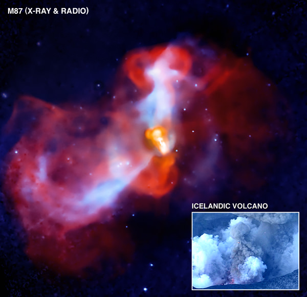
A new composite image of M87 features X-rays from Chandra (blue) and radio emission from the Very Large Array (red-orange). Credit: NASA/Chandra
[/caption]
It’s the Eyjafjallajokull of space! Chandra and the VLA have teamed up to find an erupting galactic “super-volcano” in the massive galaxy M87. Hot gas glowing in X-ray light (shown in blue) surrounds M87, and as the gas cools, it can fall toward the galaxy’s center where it should continue to cool even faster and form new stars. But radio observations with the Very Large Array (red-orange) suggest that in M87 jets of very energetic particles produced by the black hole interrupt this process. These jets lift up the relatively cool gas near the center of the galaxy and produce shock waves in the galaxy’s atmosphere because of their supersonic speed. Scientists say this action is similar to what took place with the Eyjafjallajokull volcano in Iceland that occurred in 2010.
With Eyjafjallajokull, pockets of hot gas blasted through the surface of the lava, generating shock waves that can be seen passing through the grey smoke of the volcano. This hot gas then rises up in the atmosphere, dragging the dark ash with it. Remember the close-up movie of the volcano’s eruption — (see below)? Shock waves propagating in the smoke are followed by the rise of dark ash clouds into the atmosphere.
In the case of this cosmic volcano in M87, the energetic particles produced in the vicinity of the black hole rise through the X-ray emitting atmosphere of the cluster, lifting up the coolest gas near the center of M87 in their wake. This is similar to the hot volcanic gases that drag up the clouds of dark ash. And just like the volcano here on Earth, shock waves can be seen when the black hole pumps energetic particles into the cluster gas. The Chandra team has provided a labeled version of the image which shows the energetic particles, cool gas and shock waves.
M87 is about 50 million light years from Earth and lies at the center of the Virgo cluster, which contains thousands of galaxies.
View of volcanic ash spewing from the Eyjafjallajokull volcano. Image courtesy of and copyright Snaevarr Gudmundsson.
[/caption]
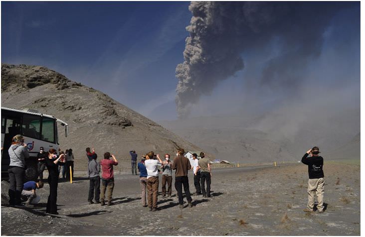
Astronomer Snaevarr Gudmundsson from Iceland, who shared his incredible close-up images of the Eyjafjallajokull volcano with Universe Today back in April, has made another trek out to visit the region near the volcano. “Under the ash clouds the world takes strange turn,” he wrote in an email. “It is hard for residents to live in the neighborhood under these circumstances. When wind turns the ash clouds over their home village it gets unbearable to stay outside. It is absolutely essential to keep mask and goggles on to prevent sore throat and eyes filled with fine grained ash. The fine grained ash fills up every pore and penetrates into houses through every weakness, like joints around doors and windows, even though it is very well sealed. As you see where the bus is near the grill house at Vik (see below) a bad ash storm was making otherwise normal life awful.”
See more of Gudmundsson’s images of the Iceland volcano and how it is affecting life in Iceland.
View of volcanic ash spewing from the Eyjafjallajokull volcano. Image courtesy of and copyright Snaevarr Gudmundsson.
'A bad ash storm was making otherwise normal life awful.' Image courtesy of and copyright Snaevarr Gudmundsson.Volcanic ash spewing from the Eyjafjallajokull volcano. Image courtesy of and copyright Snaevarr Gudmundsson.
Gudmundsson said that some images show the grass is green and one might assume everything is ok. “But the vegetation is growing through the ash layer which is up to 15 cm thick,” he said. When looking down into it the green color fades into grey ash with the grass sticking through.”
Ash on the ground. Image courtesy of and copyright Snaevarr Gudmundsson.Lava flow and ash. Image courtesy of and copyright Snaevarr Gudmundsson.Unusual clouds surround the Eyjafjallajokull volcano on a sunny day in Iceland. Image courtesy of and copyright Snaevarr Gudmundsson.Eyjafjallajokull volcano in May 2010. Image courtesy of and copyright Snaevarr Gudmundsson.Region near the Eyjafjallajokull volcano in May 2010. Image courtesy of and copyright Snaevarr Gudmundsson.Going near the volcano requires protective gear and masks. Image courtesy of and copyright Snaevarr Gudmundsson.This image was taken in 2005. Compare to the image below. Image courtesy of and copyright Snaevarr Gudmundsson.
These two photographs provide an idea of sediment disposal down into a the lagoon. “As I told you, it filled up the lagoon (believed to be 30 – 40 m deep before the eruption) in matter of two days by debris floods in the beginning of the eruption,” said Gudmundsson. “If you compare the two images from 2005 and now in May 2010 (not taken by same place) you can see how high the sediment plain reaches up to the glacier. Take note of the prominent gully and how high up it is . Indeed sediment has now buried the lower part of it so it will be curious to see what happens to the glacier in the future.”
The same area in May 2010. Image courtesy of and copyright Snaevarr Gudmundsson.
Thanks once again to Snaevarr Gudmundsson for sharing his images and insight of the Eyjafjallajokull volcano and how it is affecting life in Iceland.
Listen to a podcast on 365 Days of Astronomy of Snaevarr Gudmundsson interviewed by Col Maybury from radio station 2NUR in Australia, talking about the volcano.
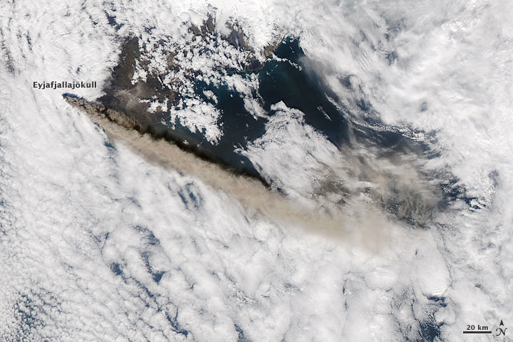
Eyjafjallajökull on May 12, 2010. NASA image by Jeff Schmaltz, MODIS Rapid Response Team at NASA GSFC.
[/caption]
Via the Bad Astronomer, there is now a live video feed of the Eyjafjallajökull volcano in Iceland. It comes in two flavors: regular (visible) and infrared, so you can see a thermal version of the feed as well. It’s not an embeddable feed, so here’s the link. I’ve been watching it for awhile, and so far, there have always been people visible in the field of view, too. Scroll down on the page, and there’s also a map that shows the location of the camera relative to the volcano.
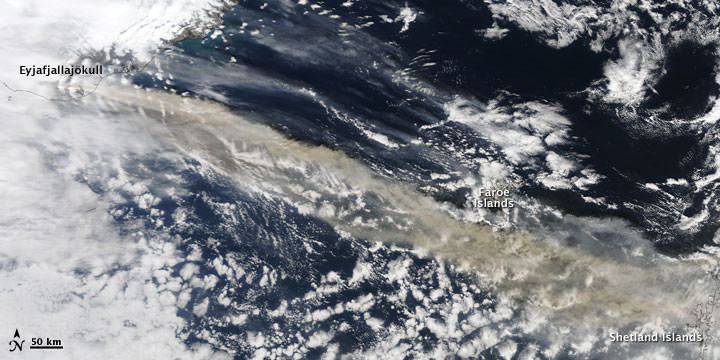
Above is the latest satellite imagery of Eyjafjallajökull, the Iceland volcano, taken on May 12, 2010, taken by the Moderate Resolution Imaging Spectroradiometer (MODIS) on NASA’s Aqua satellite. It shows the plume reaching a height of 4 to 5 kilometers (13,000-17,000 feet), even going above the clouds. The plume has switched directions from yesterday’s image, where the plume was blowing south and slightly southest; now it is blowing more easterly.
According to the Iceland Meteorological Office and the Institute of Earth Sciences at the University of Iceland, the eruption had changed little from previous days and showed no signs of stopping.
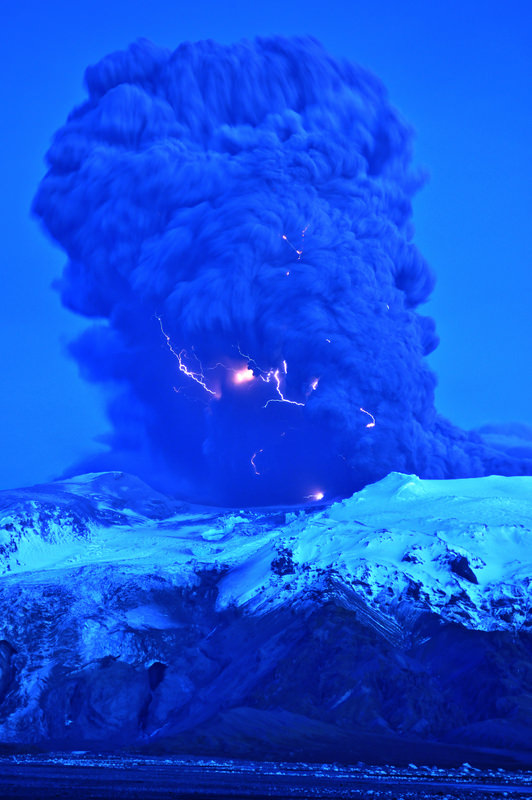
Lightning visible in the plume of the Eyjafjallajokull volcano in Iceland on April 17, 2010. Image courtesy of Snaevarr Gudmundsson.
[/caption]
Astronomer Snaevarr Gudmundsson from Iceland was able to travel to within just a few kilometers from the Eyjafjallajokull volcano, and shared his incredible close-up images with Universe Today. “I stayed near the volcano from about 16:00 hours to 22:00 hours on Saturday and watched its impressive eruption,” Gudmundsson said in an email to me. “Amazing event, awesome explosions of 1200 °C hot magma reaching ice and water. I shot more than 550 images during these hours of continuous enjoyment. Sounds ridiculous but its ever changing appearance was never boring.”
The massive plume put on an impressive display – from lightning forming within the plume to an incredible amount of spewing ash. On one of following pictures you can see helicopter for size comparison of the plume
The massive plume of Eyjafjallajokull volcano dwarfs a helicopter flying nearby (upper left). Image courtesy of and copyright Snaevarr Gudmundsson.
Gudmundsson said he and other photographers were a safe distance from the eruption, but were a few kilometers away. “Nearby was a small river and its prominent sound prevented us from hearing much in the eruption itself except a loud roar from thunders from time to time,” he said. “During daylight we even glimpsed some lightning but at dusk (the photo is taken at about 22:00 in the evening) they were easily spotted especially during active periods of explosions.”
The plume of Eyjafjallajokull volcano on April 17, 2010. Image courtesy of and copyright Snaevarr Gudmundsson.
I asked if there was any smell associated with the Iceland volcano and Gudmundsson said there was a bit of sulphuric smell in the air even though they were in a location where the wind was blowing towards the volcano. “The ash went to the other side of the volcano, as you can suggest, making life miserable for farmers and households below, but the rest of it climbed to higher altitude and from there to Europe.”
“From the foot of the volcano to the prominent top, seen in front of the tephra cloud (seen on some of the photos) the overall height is about 1300 -1400 m,” Gudmundsson said. “When the eruption began a huge flood went down beneath the obvious glacier to the left from the crater. And if you look closely on the photo showing the foot hills under the mountain a lot of icebergs can be seen on the flood plain. Under that same glacier was a rather deep lagoon (can’t been seen but sat between the two high moraines on either side of it, in front of the glacier) but sediment from the eruption filled it up in only two days at most! That is unbelievable. I have climbed this glacier many times but to approach it one usually must traverse the moraine, around the lagoon to reach the ice. But suddenly it is gone.” Another view of Eyjafjallajokull volcano on April 17, 2010. Image courtesy of and copyright Snaevarr Gudmundsson.
Gudmundsson said the flood paths can be seen below the glacier as a narrow gorges carved into rather soft volcanic sediment.
Some of the latest reports from Iceland say that in some areas the volcanic fallout has been significant, clogging car engines, turning grass grey and reducing visibility to just a few meters.
The police say driving conditions can be very difficult in these places, but the area affected is remote with only a few hundred people, most of them living in isolated homes and many of them farmers. They have been advised to stay inside with the windows and doors shut and if they do venture out to wear goggles and a mask.
The staff of Landhelgisgæslan (Icelandic Coastal Patrol) captured this radar image of the craters in Eyjafjallajökull on Friday. There are three main openings and each one is 200-500m in diameter.
Radar image of the volcano, taken by the Icelandic Coastal Patrol.
Our very special thanks to Snaevarr Gudmundsson for sharing his images and experiences of seeing the volcano “up close and personal.” Also thanks to Col Maybury of radio station 2NUR in Newcastle, Australia for connecting me with Snaevarr (yes my connection to Iceland came through Australia!) and also thanks to erlinger on Twitter for help with Icelandic translations of news reports.
NASA's Terra Satellite captured this image on April 15, 2010 of the volcano and resulting ash plume. NASA image by Jeff Schmaltz, MODIS Rapid Response Team at NASA GSFC.
A volcano under a glacier in Iceland erupted Wednesday, melting ice, shooting smoke and steam into the air and forcing hundreds of people to leave their homes. The resulting ash plume has also halted air traffic over much of Europe. Scientists said the eruption under the ice cap was 10 to 20 times more powerful than an eruption from the that happened from the Eyjafjallajokullin Volcano late last month. “This is a very much more violent eruption because it’s interacting with ice and water,” said Andy Russell, an expert in glacial flooding at the University of Newcastle in northern England, in an article on the CBC website. The dramatic footage in the video here was released today, April 15, and satellite images, below, show how far the ash plume has traveled.
[/caption]
The iceland volcano sent a plume of ash and steam across the North Atlantic prompting airspace closures in the United Kingdom, Ireland, France, and Scandinavia, which then had a ripple effect, disrupting flights to and from other countries as well. Authorities could not say how long the airspace closure would last, and the ash’s spread threatened to force closures of additional airspace over the coming days.
NASA's EO-1 Satellite took this image on April 1, 2010. NASA image by Robert Simmon, using ALI data from the EO-1 team
This natural-color satellite image shows the area of the eruption on April 1, when a new vent opened up. The image was acquired by the Advanced Land Imager (ALI) aboard NASA’s Earth Observing-1 (EO-1) satellite.
The volcano, about 120 kilometres east of Reykjavik, erupted March 20 after almost 200 years of silence.
Pall Einarsson, a geophysicist at the University of Iceland, said magma was melting a hole in the thick ice covering the volcano’s crater, sending water coursing down the glacier, and causing widespread flooding.
Iceland’s main coastal ring road was closed near the volcano, and workers smashed a hole in the highway in a bid to give the rushing water a clear route to the coast and prevent a major bridge from being swept away.


. Image courtesy of and copyright Snaevarr Gudmundsson.")