The End Of Envisat

After ten years in orbit Envisat's mission has been declared over. (ESA)

[/caption]

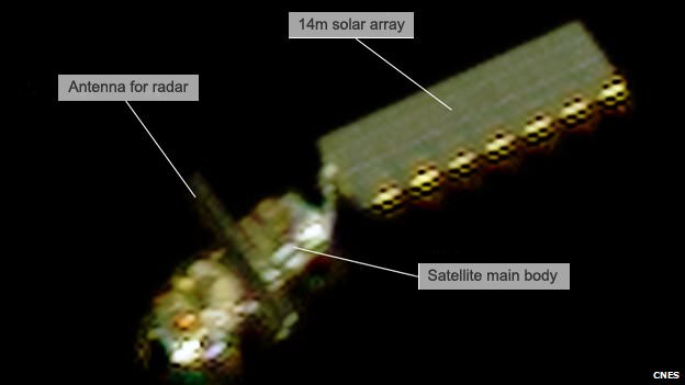
Well, it’s official. After ten years of groundbreaking observation of our planet, ESA has declared the end of the Envisat mission after losing contact with the satellite on April 8, 2012. All attempts to re-establish communication with Envisat have so far been unsuccessful, and although recovery teams will continue to determine the cause of signal loss and try to regain a signal over the next several weeks, the mission — and the satellite — have been retired.

Having performed twice as long as originally planned, the hardworking Envisat has definitely earned its rest.

On April 8, the European Space Agency lost communication with the Earth-observation satellite, preventing reception of data as it passed over the Kiruna station in Sweden. Although later confirmed that the satellite is still in orbit, the recovery team has not been able to re-establish contact.

It’s thought that a loss of a power regulator could be blocking telemetry and telecommands from reaching Envisat, or else the satellite may have experienced a short-circuit and attempted to go into “safe mode” but experienced difficulties during the transition, leaving it in an unknown state.

Read: Is This the Last Image From Envisat?

ESA states that the chances of ever regaining communication with Envisat are extremely low.

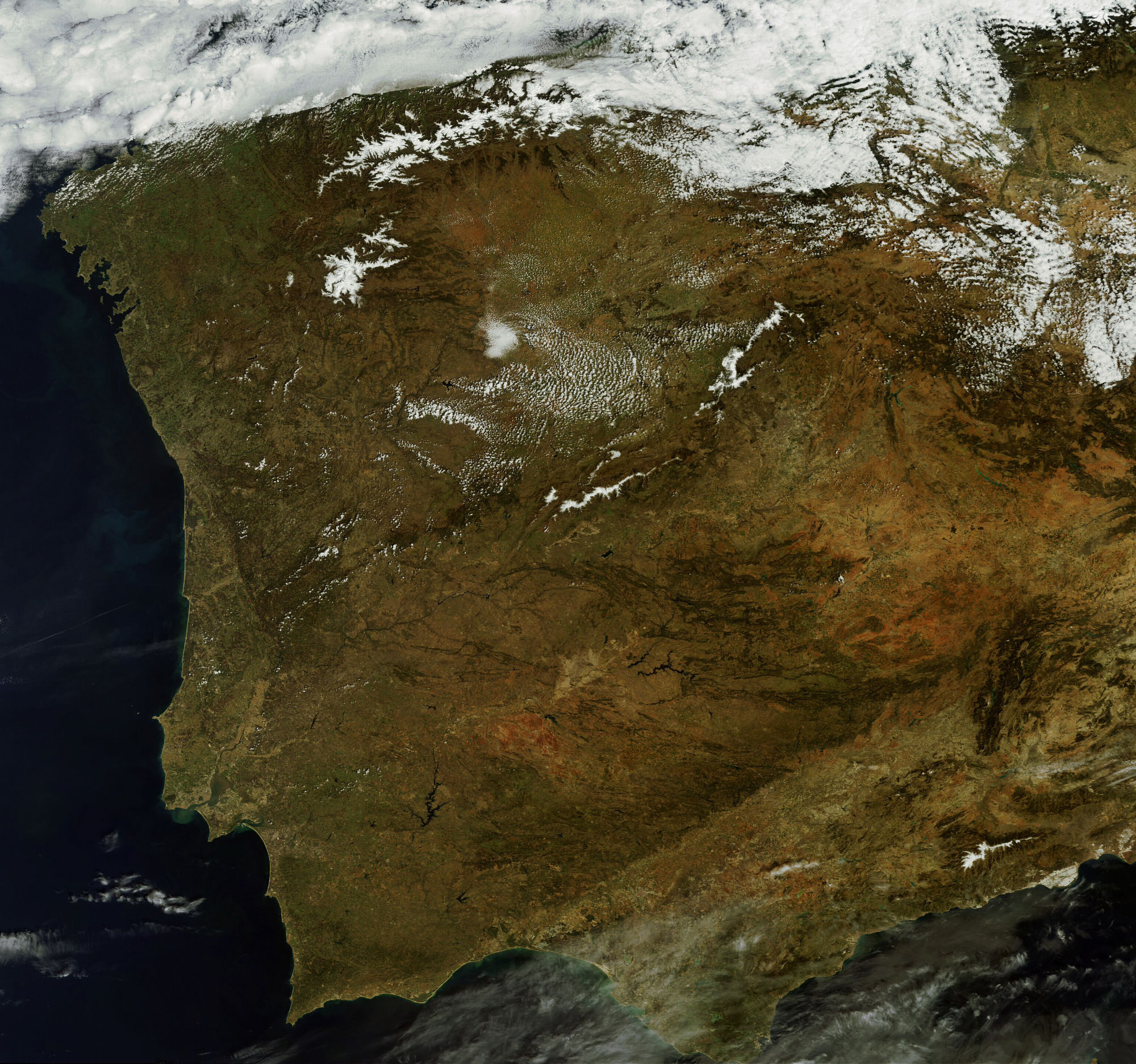
While we had reported before on the last image received before falling silent, the image below is actually the final image from Envisat, an X-band image of the Canary Islands.

The final image from Envisat, acquired on April 8, 2012. (ESA/Edisoft)

During its lifetime, Envisat completed 50,000 orbits of Earth and returned over a thousand terabytes of data, containing invaluable measurements of our planet’s surface and atmosphere that were used in more than 2500 science publications.

The video below gives a fitting eulogy for a satellite that’s definitely overachieved and over-performed, giving us a decade of crucial observations of our world from orbit.

Read more on the ESA news release here.

ESA’s Ailing Envisat Imaged by Another Earth Orbiting Satellite

France's Pleiades Earth observation satellite captured this image of the silent Envisat satellite on April 15, 2012, from a distance of about 100 km. Credit: CNES

[/caption]

ESA’s mysteriously silent Envisat Earth observing satellite has been observed and imaged by another satellite in space. France’s space agency (CNES) pulled off an on-orbit coup, using their high-resolution Pleiades satellite to take a picture of Envisat from about 100 km. The good news is that engineers were able to determine Envisat is fully intact and has not been obviously damaged by impacts by space debris or meteoroids. The massive Envisat fell silent on April 8 after 10 years of service – twice its designed lifetime — providing high quality images and data of our changing Earth.

“We are really grateful to CNES for offering to acquire images of Envisat using their Pleiades and Spot satellites,” said Volker Liebig, ESA’s Director of Earth Observation Programs. “Additional observations being acquired across the globe show how the international space community has come together to track this veteran satellite.”

Previous optical, radar and laser observations of Envisat show it is still in a stable orbit. However, engineers have not even been able to determine if the satellite is in ‘safe mode’ or if it has just gone dead. They say knowing this would be a starting point for revival and the recovery team is drawing on every information source available. If it is in safe mode, it may be possible to re-establish communications.

CNES was able to rotate the Pleiades satellite to capture images of Envisat. These images are being used to determine the orientation of Envisat’s solar panel – the satellite’s power source – to see if it is in a good position to generate power.

Envisat has been helping researchers examine our planet, completing more than 50,000 orbits and returned thousands of images, as well as a wealth of data about the land, oceans and atmosphere.

Source: ESA

Is This The Last Image From Envisat?

This MERIS image of Spain and Portugal could be Envisat's last. (Chelys/EOsnap)

[/caption]

The European Space Agency’s venerable Envisat satellite may have sent back its final image, according to recent news from the Agency.

On April 8, ESA lost communication with the Earth-observation satellite, preventing reception of data as it passed over the Kiruna station in Sweden. Although it’s been confirmed that the satellite is still in orbit, the recovery team has not been able to re-establish contact.

The image above, showing part of the Iberian peninsula, was from the last data to be received from Envisat before it fell silent.

Radar image of Envisat. (Fraunhofer Institute for High Frequency Physics and Radar Techniques.)

Launched in March 2002, Envisat has been helping researchers examine our planet for over ten years — five years longer than its original mission duration. It has completed more than 50,000 orbits and returned thousands of images, as well as a wealth of data about the land, oceans and atmosphere.

Envisat data was instrumental in over 4,000 projects from 70 countries.

Germany’s Tracking and Imaging Radar captured an image of the satellite, revealing that it is still intact and in a stable orbit. Still, all attempts at recovery have so far been unsuccessful.

A contingency agreement with the Canadian Space Agency on Radarsat will be activated to fulfill user requirements if Envisat cannot be brought back online.

Read the official release on the ESA site here.

As Seen From Space: Beautiful Swirling Phytoplankton Blooms

A phytoplankton bloom swirls a figure-8 in the South Atlantic Ocean. Credit: ESA, Envisat

[/caption]

One of the orbiting windows to our world, an Earth-observing satellite named Envisat, took this image in early December 2011 showing a phytoplankton bloom swirling into a figure-8 in the South Atlantic Ocean about 600 km east of the Falkland Islands. The European Space Agency says that since the phytoplankton are sensitive to environmental changes, it is important to monitor and model them for climate change calculations and to identify potentially harmful blooms. Sensors on the satellites can monitor these algal blooms and make an initial identification of its species and toxicity.

Blooms like this are common in the spring and summer, and it is currently summer in the southern hemisphere.

These microscopic organisms are the base of the marine food chain, and play a huge role in the removal of carbon dioxide from the atmosphere and the production of oxygen in the oceans. Besides being beautiful to see from space, phytoplankton help regulate the carbon cycle, and are important to the global climate system.

Source: ESA