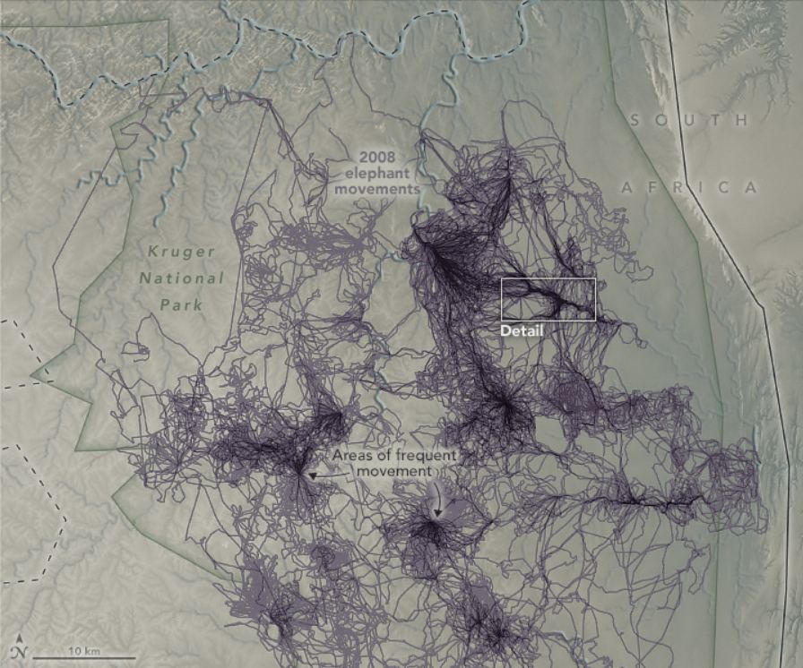
This map shows how elephants moved across Kruger National Park in South Africa over one year. Image Credit: Thaker, M., et al. (2019)
Scientists have been underutilizing a key resource we can use to help us understand Earth: animals. Our fellow Earthlings have a much different, and usually much more direct, relationship with the Earth. They move around the planet in ways and to places we don’t.
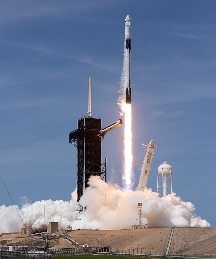
There are few things in this world that brings feelings of awe and wonder more than a rocket launch. Watching a literal tower of steel slowly lift off from the ground with unspeakable power reminds us of what humanity can achieve despite our flaws, disagreements, and differences, and for the briefest of moments these magnificent spectacles are capable of bringing us all together regardless of race, creed, and religion.
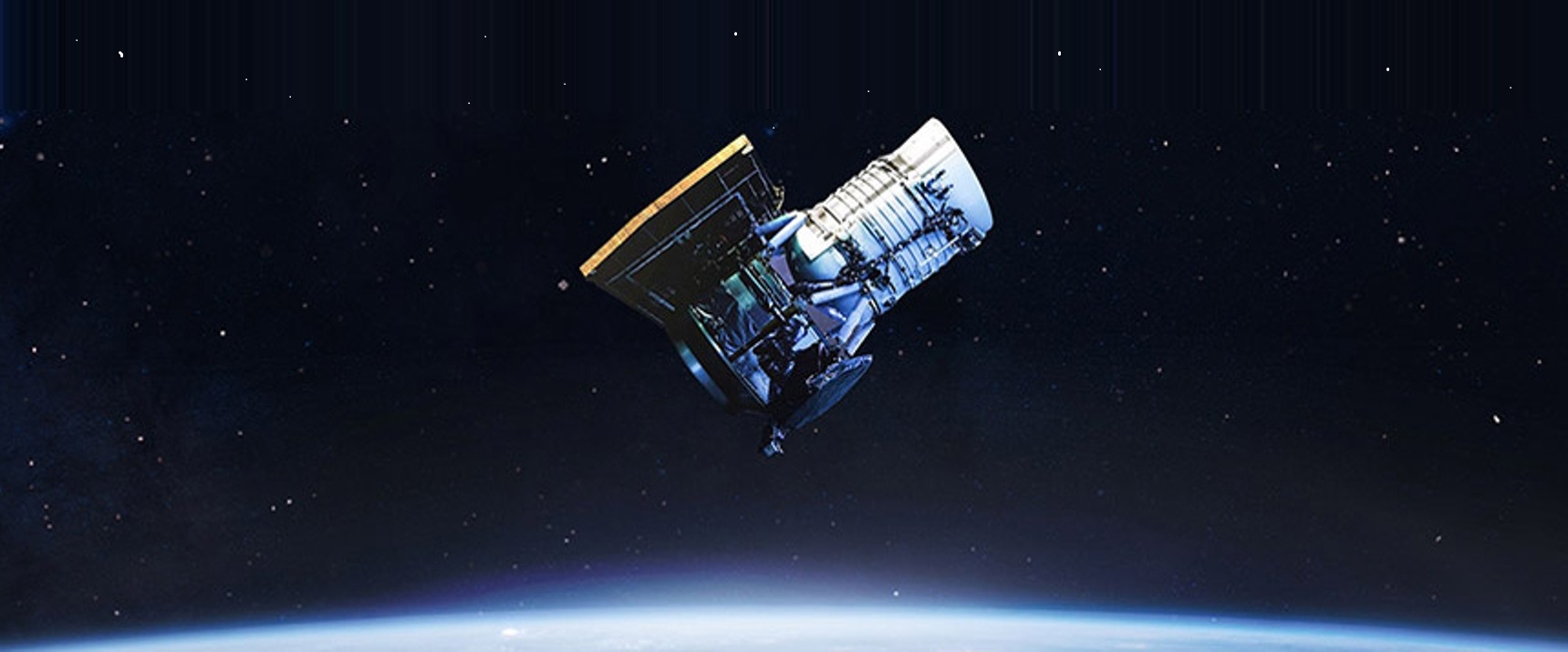
An artist's conception shows MethaneSAT in orbit. (MethaneSAT Illustration)
Billionaires Jeff Bezos and Elon Musk are usually rivals on the final frontier, but they both have a role to play in MethaneSAT, a privately backed satellite mission aimed at monitoring methane emissions.
Last November, the Bezos Earth Fund made a $100 million grant to the Environmental Defense Fund to support the satellite’s completion and launch. That grant was part of a $791 million round that Bezos said was “just the beginning of my $10 billion commitment” to address challenges brought on by climate change.
Now MethaneSAT LLC — a subsidiary of Environmental Defense Fund — is announcing that it’s signed a contract with Musk’s SpaceX to send the satellite into orbit on a Falcon 9 rocket by as early as October 2022.
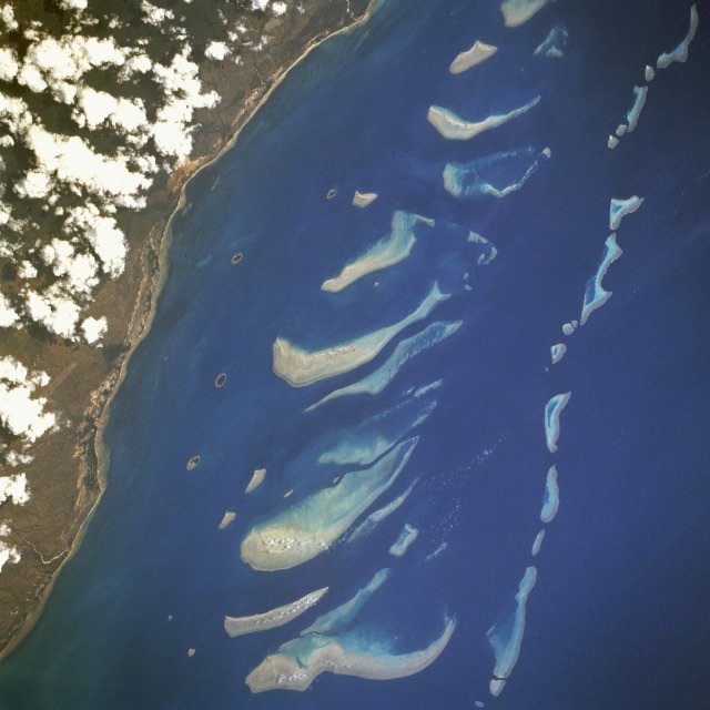
Great Barrier Reef, Queensland, Australia August 1992
A new study found that warmer ocean temperatures driven by climate change have caused Australia’s Great Barrier Reef to lose more than half of its corals since 1995. The researchers say virtually all coral populations along the Great Barrier Reef have declined due to repeated “bleaching events” in the past 25 years. They said the devastation of the coral will continue unless action is taken to mitigate the causes of a warming climate.
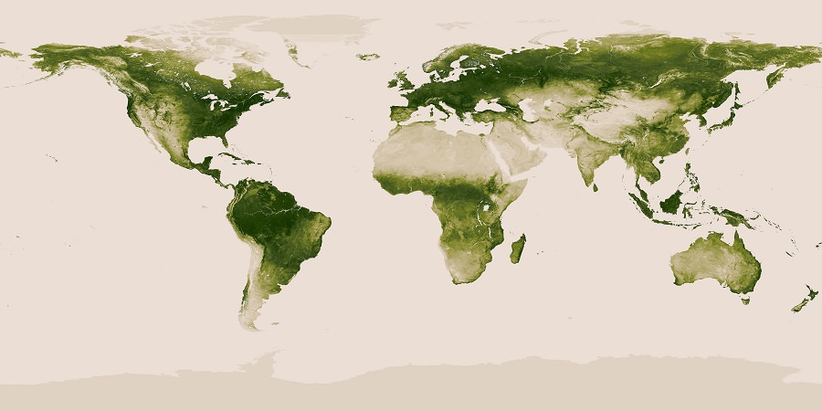
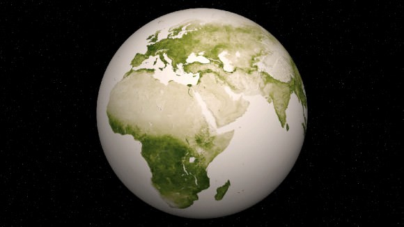
Earth’s Vegetation. World map of vegetation created with Suomi NPP data. Credit: NASA/NOAA
Earth’s Vegetation from Suomi NPP satellite. World map of vegetation data collected by the Suomi NPP satellite (National Polar-orbiting Partnership) in a partnership between NASA and the National Oceanic and Atmospheric Administration (NOAA). Credit: NASA/NOAA
Photo and Video Gallery below[/caption]
Herbal Earth: that’s the title of a spectacular collection of vivid new views of the Earth’s vegetation captured over the past year by the Suomi NPP satellite.
NPP is short for National Polar-orbiting Partnership – an Earth science satellite partnership between NASA and the National Oceanic and Atmospheric Administration (NOAA).
Although it’s rather reminiscent of the manmade ‘World at Night’ – its actually the ‘Natural World of Living Green Life.’
The Suomi NPP satellite data were collected with the Visible-Infrared Imager/Radiometer Suite (VIIRS) instrument from April 2012 to April 2013 and used to generate this gallery of images and animations – released by NASA and NOAA on June 19.
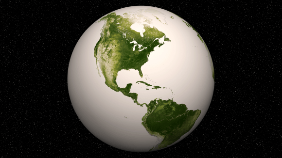
Western Hemisphere -Vegetation on Our Planet. The darkest green areas are the lushest in vegetation, while the pale colors are sparse in vegetation cover either due to snow, drought, rock, or urban areas. Suomi NPP Satellite data from April 2012 to April 2013 was used to generate these images. Credit: NASA/NOAA
Suomi NPP was launched on October 28, 2011 by a Delta II rocket and placed into a sun-synchronous orbit 824 km (512 miles) above the Earth. It orbits Earth about 14 times daily.
The VIIRS instrument measures vegetation changes over time by looking at changes in the visible and near-infrared light reflected by vegetation. The 22-band radiometer sensor can detect subtle differences in greenness.
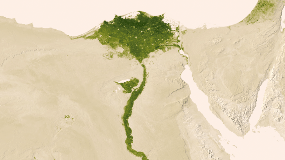
Nile Delta: July 9-15, 2012. Amidst the deserts of Egypt, the Nile River provides life-sustaining water to the region. Also visible are the urbanized areas of northern Egypt. Credit: NASA/NOAA
The data are incorporated into the Normalized Difference Vegetation Index (NDVI) which represents the photosynthetic potential of vegetation.
The NVDI measures and monitors plant growth, vegetation cover and biomass production from the Suomi NPP satellite information.
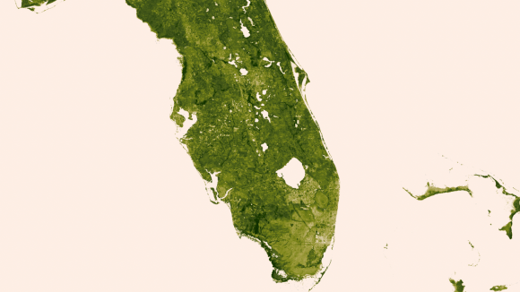
The Florida Everglades: March 18-24, 2013. The “river of grass” extending south of Lake Okeechobee shows clear signs of its modified state with areas of dense agriculture, urban sprawl and water conservation areas delineated by a series of waterways that crisscross Southern Florida. Credit: NASA/NOAA
A quarter of the Earth’s surface is covered by some green vegetation, the remainder is the blue ocean.
Video: Green- Vegetation on Our Planet (Tour of Earth)
And don’t forget to “Send Your Name to Mars” aboard NASA’s MAVEN orbiter- details here. Deadline Very Soon: July 1, 2013. Launch: Nov. 18, 2013
…………….
Learn more about Earth, Mars, Curiosity, Opportunity, MAVEN, LADEE and NASA missions at Ken’s upcoming presentation
June 23: “Send your Name to Mars on MAVEN” and “CIBER Astro Sat, LADEE Lunar & Antares Rocket Launches from Virginia”; Rodeway Inn, Chincoteague, VA, 8 PM
Eastern Hemisphere -Vegetation on Our Planet. Credit: NASA/NOAA
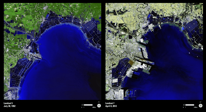
NASA’s first Earth-observing Landsat satellite launched from Vandenberg Air Force Base on July 23, 1972, and to celebrate the 40th anniversary of the program they asked the public to vote on their favorite images of the planet from the Landsat Earth as Art gallery. After over 14,000 votes, these were chosen as the top 5 favorites. Happy 40th anniversary, Landsat!
Landsat images from space are not merely pictures. They contain many layers of data collected at different points along the visible and invisible light spectrum. A single Landsat scene taken from 400 miles above Earth can accurately detail the condition of hundreds of thousands of acres of grassland, agricultural crops or forests.
“Landsat has given us a critical perspective on our planet over the long term and will continue to help us understand the big picture of Earth and its changes from space,” said NASA Administrator Charles Bolden. “With this view we are better prepared to take action on the ground and be better stewards of our home.”
In cooperation with the U.S. Geological Survey (USGS), a science agency of the Interior Department, NASA launched six of the seven Landsat satellites. The resulting archive of Earth observations forms a comprehensive record of human and natural land changes.
“The first 40 years of the Landsat program have delivered the most consistent and reliable record of Earth’s changing landscape.”
– Michael Freilich, director of NASA’s Earth Science Division
“Over four decades, data from the Landsat series of satellites have become a vital reference worldwide for advancing our understanding of the science of the land,” said Interior Department Secretary Ken Salazar. “The 40-year Landsat archive forms an indelible and objective register of America’s natural heritage and thus it has become part of this department’s legacy to the American people.”
The next satellite in the series, the Landsat Data Continuity Mission (LDCM) is scheduled to launch on February 11, 2013.
(Source: NASA/GSFC)
Find out more about the ongoing Landsat mission here, and see recent visualizations from Landsat on the USGS site here.
Video: NASA/GSFC. Inset image: Industrial growth in Binhai New Area, China. Sub-feature: Erg Iguidi, an area of ever-shifting sand dunes extending from Algeria into Mauritania in northwestern Africa, one of the chosen top 5 Earth as Art images. NASA/GSFC/USGS.
You’ve seen all the videos and images we’ve been featuring lately that astronauts on the International Space Station have taken of Earth from orbit. The one ubiquitous feature is the amount of lights showing up from cities and towns around the world.
According to conventional thinking, plant life first took hold on Earth after oceans and rivers formed; the soil produced by liquid water breaking down bare rock provided an ideal medium for plants to grow in. It certainly sounds logical, but a new study is challenging that view – the theory is that vascular plants, those containing a transport system for water and nutrients, actually created a cycle of glaciation and melting, conditions which led to the formation of rivers and mud which allowed forests and farmland to later develop. In short, they helped actually create the landscapes we see today.
The evidence was just published in two articles in a special edition of Nature Geoscience.
In the first article, analysis of the data proposes that vascular plants began to absorb the carbon dioxide in the atmosphere about 450 million years ago. This led to a cooling of temperatures on a global scale, resulting in widespread glaciation. As the glaciers later started to melt, they ground up the Earth’s surface, forming the kind of soils we see today.
The second article goes further, stating that today’s rivers were also created by vascular plants – the vegetation broke the rocks down into mud and minerals and then also held the mud in place. This caused river banks to start forming, acting as channels for water, which up until then had tended to flow over the surface much more randomly. As the water was channeled into more specific routes, rivers formed. This led to periodic flooding; sediments were deposited over large areas which created rich soil. As trees were able to take root in this new soil, debris from the trees fell into the rivers, creating logjams. This had the effect of creating new rivers and causing more flooding. These larger fertile areas were then able to support the growth of larger lush forests and farmland.
According to Martin Gibling, a professor of Earth science at Dalhousie University, “Sedimentary rocks, before plants, contained almost no mud. But after plants developed, the mud content increased dramatically. Muddy landscapes expanded greatly. A new kind of eco-space was created that wasn’t there before.”
The new theory also leads to the possibility that any exoplanets that happen to have vegetation would look different from Earth; varying circumstances would create a surface unique to each world. Any truly Earth-like exoplanets might be very similar in general, but the way that their surfaces have been modified might be rather different.
It’s an interesting scenario, but it also raises other questions. What about the ancient river channels on Mars? Some appear to have been formed by brief catastrophic floods, but others seem more similar to long-lived rivers here on Earth, especially if there actually was a northern hemisphere ocean as well. How did they form? Does this mean that rivers could form in a variety of ways, with or without plant life being involved? Could Mars have once had something equivalent to vascular plant life as well? Or could the new theory just be wrong? Then there’s Titan, which has numerous rivers still flowing today. Albeit they are liquid methane/ethane instead of water, but what exactly led to their formation?
Without the workings of life, the Earth would not be the planet it is today. Even if there are a number of planets that could support tectonics, running water and the chemical cycles that are essential for life as we know it, it seems unlikely that any of them would look like Earth. Even if evolution follows a predictable path, filling all available niches in a reproducible and consistent way, the niches on any Earth analogue could be different if the composition of its surface and atmosphere are not identical to those of Earth. And if evolution is random, the differences would be expected to be even larger. Either way, a glimpse of the surface of an exoplanet — if we ever get one — may give us a whole new perspective on biogeochemical cycling and geomorphology.
Just as the many exoplanets now being found are of a previously unknown and amazingly wide variety, and all uniquely alien, even the ones that (may) support life are likely to be just as diverse from each other as they are from Earth itself. Earth’s “twin” may be out there, but in terms of outward appearance, it may be somewhat more of a fraternal twin than an exact replica.
NASA put out this video last week and we missed covering it, but this is a very interesting little video that takes you on a narrated global tour of tens of millions of fires detected from space between July 2002 and July 2011. Yes, that’s right, tens of millions of fires on Earth, and these aren’t tiny little campfires — they are big enough to be seen from space. The video was created from new satellite data visualizations, and is combined with satellite views of vegetation and snow cover to show how fires relate to seasonal changes. The research helps scientists understand how fire affects our environment on local, regional and global scales. Continue reading “As the World Burns: Satellites Watch Fires Around the World”
It happens every winter, and even more so during the recent cold snap here in the US: frequently people say, “Well, so much for global warming! Guess that’s not an issue anymore!” But there’s only one way to respond to that: “WRONG.”
I was going to write an article about the difference between climate and weather, but I came across a great video series on You Tube called Climate Denial Crock of the Week, put together by Peter Sinclair, a longtime advocate of environmental awareness and energy alternatives, and Sinclair says everything better than I could. This video takes the 10-second sound bites used by those who deny climate change is occurring, and intelligently breaks them down one by one. Continue reading “Climate Vs. Weather Video”