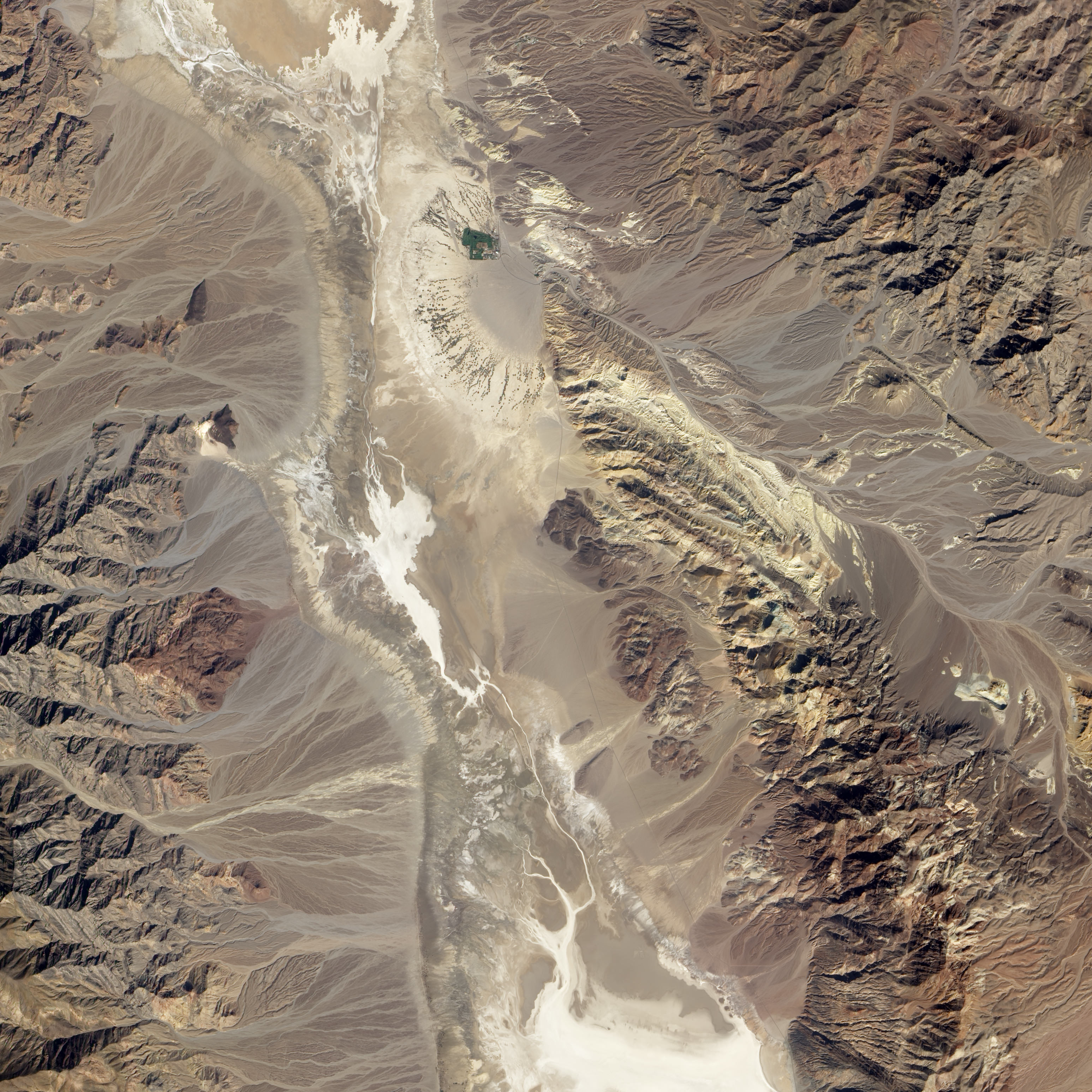
The Badwater Basin region of California’s Death Valley acquired by NASA’s Earth Observing-1 satellite (EO-1) on October 23, 2002. Alluvial fans in the image are remarkably similar to the terrain that the Curiosity rover will explore on Mars. Image and annotations from NASA Earth Observatory
Leave it to NASA’s Earth Observtory folks to come up with a terrestrial image that captures the familiar terrain the car-sized rover Curiosity will explore on Mars.
“You would really be forgiven for thinking that NASA was trying to pull a fast one on you, and we actually put a rover out in the Mojave Desert and took a picture,” said project scientist John Grotzinger during a recent press conference.
Curiosity set down along a fan-shaped apron of dirt and debris known as an alluvial fan. The landform likely formed when liquid water flowed down the side of Gale Crater through a network of stream channels and valleys onto the crater floor. Although no liquid water seems to exist on the surface of Mars, the tell-tale traces of liquid water’s flow is abundant.
 Gaze down onto the Badwater Basin area of California’s Death Valley National Park in this image from NASA’s Earth Observing-1 Satellite (EO-1). Take a peek at the earthimagified version. Alluvial fans are abundant in this image. Occasional storms send flash floods rushing down canyons in this arid landscape. The water transports sediment from the mountains and deposits them in the fan-shaped patterns we see in the image. The white region to the left of the image is a salt flat; the remains of a dried up lake. Scientists note that Gale Crater is also a basin with no outlets so water that pooled in the crater may leave behind similar salts and deposits.
The NASA site also points out that many features, including wind, volcanism, and alternating wet and dry conditions, make this area a perfect laboratory for planning missions to Mars. In fact, a dark patch just north of the large alluvial fan to the left of the image is called Mars Hill due to its similarity to features seen at the Viking 1 landing site. Viking 1 landed on Mars July 20, 1976.
There is a primary difference between the landscapes and features of Gale Crater and Badwater Basin and that is age. The features of Death Valley are billions of years younger than those found on Mars and the site continues to be shaped by water. Scientists believe water stopped flowing on Mars billions of years ago; the sediments deposited by ancient rivers on Mars buried by eons of wind-driven erosion.
John Williams is a science writer and owner of TerraZoom, a Colorado-based web development shop specializing in web mapping and online image zooms. He also writes the award-winning blog, StarryCritters, an interactive site devoted to looking at images from NASA’s Great Observatories and other sources in a different way. A former contributing editor for Final Frontier, his work has appeared in the Planetary Society Blog, Air & Space Smithsonian, Astronomy, Earth, MX Developer’s Journal, The Kansas City Star and many other newspapers and magazines.