
I was traveling the day this video was released, so missed posting it earlier. If you haven’t seen it yet, this animation of ocean surface currents is just mesmerizing. It shows ocean currents from June 2005 to December 2007, created with data from NASA satellites. In the video you can see how bigger currents like the Gulf Stream in the Atlantic Ocean and the Kuroshio in the Pacific carry warm waters across thousands of kilometers at speeds greater than six kilometers per hour 4 mph), as well as seeing how thousands of other ocean create slow-moving, circular pools called eddies. The entire visualization is reminiscent of Vincent Van Gogh’s “Starry Night” painting.
Continue reading “Earth’s Van Gogh Oceans”
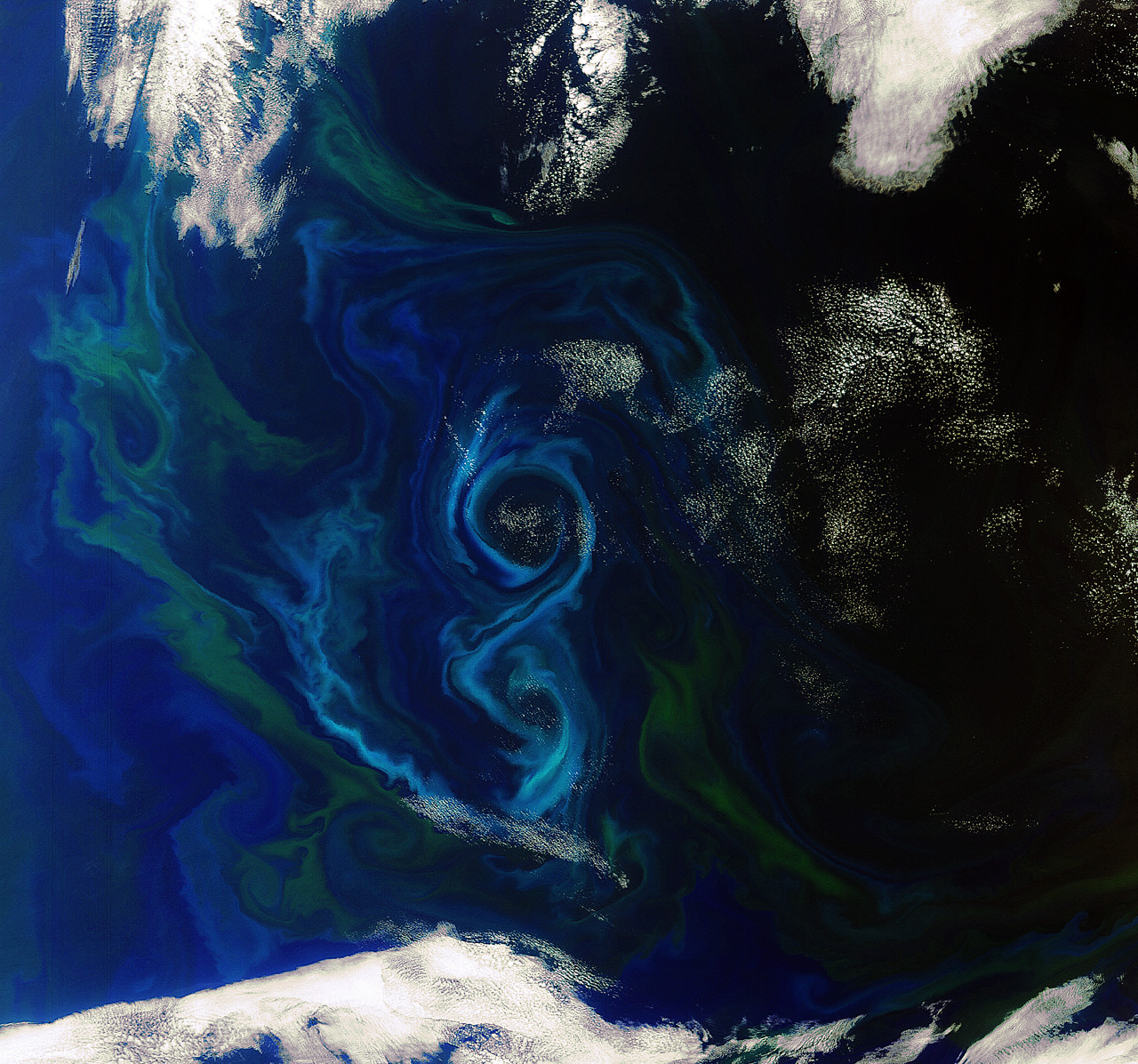
As Seen From Space: Beautiful Swirling Phytoplankton Blooms
[/caption]
One of the orbiting windows to our world, an Earth-observing satellite named Envisat, took this image in early December 2011 showing a phytoplankton bloom swirling into a figure-8 in the South Atlantic Ocean about 600 km east of the Falkland Islands. The European Space Agency says that since the phytoplankton are sensitive to environmental changes, it is important to monitor and model them for climate change calculations and to identify potentially harmful blooms. Sensors on the satellites can monitor these algal blooms and make an initial identification of its species and toxicity.
Blooms like this are common in the spring and summer, and it is currently summer in the southern hemisphere.
These microscopic organisms are the base of the marine food chain, and play a huge role in the removal of carbon dioxide from the atmosphere and the production of oxygen in the oceans. Besides being beautiful to see from space, phytoplankton help regulate the carbon cycle, and are important to the global climate system.
Source: ESA
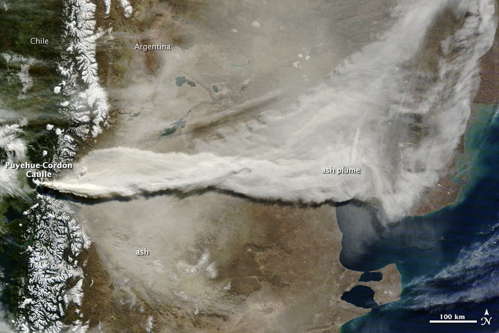
Astounding Satellite Views of the Puyehue-Cordón Ash Plume
[/caption]
An incredible amount of ash is being spewed from the erupting Puyehue-Cordón Volcano Complex in Chile. This image, taken by the Moderate Resolution Imaging Spectroradiometer (MODIS) on the Terra satellite on June 13, 2011, shows a large plume of volcanic ash blowing about 780 kilometers east and then northeast over Argentina. A plume of volcanic ash from this eruption disrupted air traffic as far away as New Zealand on June 13. See images below of how far the ash has traveled in the atmosphere, a half a world away.
The Moderate Resolution Imaging Spectroradiometer (MODIS) on the Aqua satellite acquired the two images below of the Chilean ash plume on June 13, 2011 showing that a concentrated plume was visible more than half a world away. The first image shows the ash plume over southern Australia and the Tasman Sea, while the second image provides a view farther east over New Zealand and the South Pacific Ocean.


NASA’s Earth Observatory website says that although the intensity of the eruption has decreased since the initial eruption, the volcano’s activity is holding steady. The plume reached between 4 and 8 kilometers in altitude on June 13, its height varying with the intensity of the eruptive episode throughout the day.
Here’s how the volcano looked back on June 4, 2011 when it began spewing ash 45,000 feet (14,000 meters) into the air. The Moderate Resolution Imaging Spectroradiometer (MODIS) on the Aqua satellite captured this natural-color image shortly after the eruption began:

See more images and data on this volcano at the NASA Earth Observatory Natural Hazards website.
You can follow Universe Today senior editor Nancy Atkinson on Twitter: @Nancy_A. Follow Universe Today for the latest space and astronomy news on Twitter @universetoday and on Facebook.