Here’s How to Follow the De-Orbit of Tiangong-1, now Estimated to Happen Between March 30 and April 2

Artist's illustration of China's 8-ton Tiangong-1 space station, which is expected to fall to Earth in late 2017. Credit: CMSE.

China’s Tiangong-1 space station has been the focus of a lot of international attention lately. In 2016, after four and half years in orbit, this prototype space station officially ended its mission. By September of 2017, the Agency acknowledged that the station’s orbit was decaying and that it would fall to Earth later in the year. Since then, estimates on when it will enter out atmosphere have been extended a few times.

According to satellite trackers, it was predicted that the station would fall to Earth in mid-March. But in a recent statement (which is no joke) the Chinese National Space Agency (CNSA) has indicated that Tiangong-1 will fall to Earth around April 1st – aka. April Fool’s Day. While the agency and others insists that it is very unlikely, there is a small chance that the re-entry could lead to some debris falling to Earth.

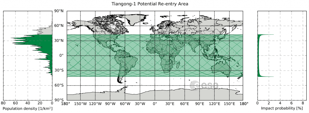
For the sake of ensuring public safety, the European Space Agency’s (ESA) Space Debris Office (SDO) has been providing regular updates on the station’s decay. According to the SDO, the reentry window is highly variable and spans from the morning of March 31st to the afternoon of April 1st (in UTC time). This works out to the evening of March 30th or March 31st for people living on the West Coast.

The possible re-entry region of the Tiangong-1 space station, indicated in green. Credit: ESA/SDO

As the ESA stated on their rocket science blog:

“Reentry will take place anywhere between 43ºN and 43ºS. Areas above or below these latitudes can be excluded. At no time will a precise time/location prediction from ESA be possible. This forecast was updated approximately weekly through to mid-March, and is now being updated every 1~2 days.”

In other words, if any debris does fall to the surface, it could happen anywhere from the Northern US, Southern Europe, Central Asia or China to the tip of Argentina/Chile, South Africa, or Australia. Basically, it could land just about anywhere on the planet. On the other hand, back in January, the US-based Aerospace Corporation released a comprehensive analysis on Tiangong-1s orbital decay.

Their analysis included a map (shown below) which illustrated the zones of highest risk. Whereas the blue areas (that make up one-third of the Earth’s surface) indicate zones of zero probability, the green area indicates a zone of lower probability. The yellow areas, meanwhile, indicates zones that have a higher probability, which extend a few degrees south of 42.7° N and north of 42.7° S latitude, respectively.

The Aerospace Corporations predicted reentry for Tiangong-1. Credit: aerospace.org

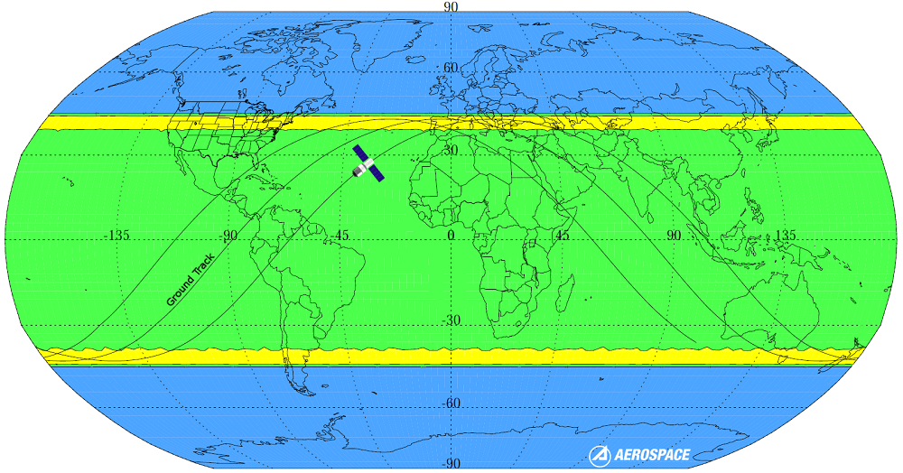
The Aerospace Corporation has also created a dashboard for tracking Tiangong-1 (which is refreshed every few minutes) and has come to similar conclusions about the station’s orbital decay. Their latest prediction is that the station will descend into our atmosphere on April 1st, at 04:35 UTC (March 30th 08:35 PST), with a margin of error of about 24 hours – in other words, between March 30th to April 2nd.

And they are hardly alone when it comes to monitoring Tiangong-1’s orbit and predicting its descent. The China Human Spaceflight Agency (CMSA) recently began providing daily updates on the orbital status of Tiangong-1. As they reported on March 28th: “Tiangong-1 stayed at an average altitude of about 202.3 km. The estimated reentry window is between 31 March and 2 April, Beijing time.”

The US Space Surveillance Network, which is responsible for tracking artificial objects in Earth’s orbit, has also been monitoring Tiangong-1 and providing daily updates. Based on their latest tracking data, they estimate that the station will enter our atmosphere no later than midnight on April 3rd.

Naturally, one cannot help but notice that these predictions vary and are subject to a margin of error. In addition, trackers cannot say with any accuracy where debris – if any – will land on the planet. As Max Fagin – an aerospace engineer and space camp alumni – explained in a recent Youtube video (posted below), all of this arises from two factors: the station’s flight path and the Earth’s atmosphere.

Basically, the station is still moving at a velocity of 7.8 km/sec (4.8 mi/s) horizontally while it is descending by about 3 cm/sec. In addition, the Earth’s atmosphere shrinks and expands throughout the day in response to the Sun’s heating, which results in changes in air resistance. This makes the process of knowing where the station’s will make its descent difficult to predict, not to mention where debris could fall.

However, as Fagin goes on to explain, once the station reaches an altitude of 150 km (93 mi) – i.e. within the Thermosphere – it will begin falling much faster. At that point, it be much easier to determine where debris (if any) will fall. However, as the ESA, CNSA, and other trackers have emphasized repeatedly, the odds of any debris making it to the surface is highly unlikely.

If any debris does survive re-entry, it is also statistically likely to fall into the ocean or in a remote area – far away from any population centers. But in all likelihood, the station will break up completely in our atmosphere and produce a beautiful streaking effect across the sky. So if you’re checking the updates regularly and are in a part of the world where it can be seen, be sure to get outside and see it!

Further Reading: GB Times

Mystery Blur in Mars Image Explained

When Curiosity executed a perfect six-wheel landing on Mars on the morning of August 6 to the excitement of millions worldwide — not to mention quite a few engineers and scientists at JPL — it immediately began relaying images back to Earth. Although the initial views were low-resolution and taken through dusty lens covers, features of the local landscape around the rover could be discerned… distant hills, a pebbly surface, the rise of Gale Crater’s central peak — and a curious dark blur on the horizon that wasn’t visible in later images.

What could it have been? Another bit of lens dust? An image artifact? A piece of ancient Martian architecture that NASA demanded be erased from the image? As it turns out, it was most likely something even cooler (or at least real): the result of Curiosity’s descent stage crash-landing into the Martian surface.

Seen in an image from NASA’s Mars Reconnaissance Orbiter’s HiRISE camera, the remnants of Curiosity’s descent to Mars are scattered around the landing site. The heat shield, parachute, back shell — and undeniably the star player of Curiosity’s EDL sequence, the descent stage and sky crane — all landed in relatively close proximity to where the rover touched down. As it turned out, Curiosity’s’s rear Hazcam happened to be aimed right where the sky crane landed after it severed Curiosity’s bridles and rocketed safely away — just as it had been shown in the landing animation.

See an infographic on Curiosity’s EDL timeline here.

Seen in the first images captured by Curiosity’s rear Hazcams just minutes after touchdown — but not in higher-resolution images acquired later — the dark blur is now thought to be a plume of dust and soil kicked up by the sky crane’s impact.

“We know that the cloud was real because we saw it in both the left and right rear Hazcams, so it wasn’t just a smudge on the lens cover or anything like that… and then 45 minutes later it was gone,” said Steven Sell, Deputy Operations for Entry, Descent and Landing at JPL, during an interview with Universe Today on Friday.

“When we were putting together the sequence of images of what would happen after touchdown, we specifically put in the Hazcam shots as soon as we could on the off chance that we would see something,” Sell said. “It was just one of those things where we had some choices we could make, and we said if we put these really close to landing maybe we’ll actually see part of the descent stage.”

Although capturing the sky crane or other part of the descent stage on camera was an intriguing idea, it wasn’t any particular goal of the mission.

“We know that the cloud was real because we saw it in both the left and right rear Hazcams, so it wasn’t just a smudge on the lens cover or anything like that.”

– Steven Sell, Deputy Operations for Entry, Descent and Landing at JPL in Pasadena, CA

“We literally weren’t even thinking about it,” Sell said. “It’s a total bonus that we were able to capture that.”

Unfortunately, the plume only appears in the initial Hazcam shots, which were taken through lens covers coated with dust from landing. It wasn’t until nearly an hour later that the covers were removed and clearer images were captured, and by then the plume was gone. Plus the Hazcams themselves are low-resolution by design — they’re more for navigation than landscape photography.

“Those cameras are not intended for doing that kind of science, or even any science at all,” said Sell. “They’re strictly engineering cameras.”

It’s been said that the best camera is the one you have with you, and in this case Curiosity’s best camera happened to be aimed in the right place at the right time. Plus the sky crane just so happened to land in view of the cameras that got turned on first, which wasn’t a guarantee.

“The descent stage had two possible directions to go: it could have gone forward or backward,” Sell explained. “The way it decides which way to go is whichever direction would take it more north. We knew that the science target is toward the south — the scientists want to study the mountain — and so we didn’t want to throw the descent stage toward the mountain.

Read: Curiosity’s First 360-Degree Color Panorama

“The good news is that the forward Hazcams were at a lower temperature upon landing, we knew they were going to be colder,” Sell said. “The cameras have to reach a certain temperature before they can take a picture, so we knew the rear Hazcams were going to get the picture first, and so the fact that the thing flew to the rear was another coincidence.”

About the same mass as the rover itself, the sky crane weighed about 800 kg (1700 lbs) at the time of impact  — including 100 kg of fuel — and hit going 100 mph. That’s going to kick up a good-sized plume (although exactly how large has yet to be determined.)

“It was one hell of an impact,” Sell said.

You can watch Steve Sell describe this and other data from the first few days of the MSL mission in the press conference held at JPL on Friday, August 10 below, and follow Sell on his Twitter feed here.


Images: NASA/JPL-Caltech. HiRISE image NASA/JPL/University of Arizona.