Satellite Images Show Oil Slick on the Move Towards Florida, Possibly East Coast of US

A satellite image from the Moderate Resolution Imaging Spectroradiometer (MODIS) on NASA’s Terra satellite on May 17, 2010, showing a long ribbon of oil stretched far to the southeast. Credit: NASA NASA image by Jeff Schmaltz, MODIS Rapid Response Team.

[/caption]

Confirming some of the worst fears about the Deepwater Horizon oil spill in the Gulf of Mexico, satellite images now show part of the oil slick has entered the Loop Current, a powerful conveyor belt-like current that flows clockwise around the Gulf of Mexico towards Florida. The Loop Current joins the Gulf Stream — the northern hemisphere’s most important ocean-current system — and the oil could enter this system and be carried up to the US East Coast.

Both NASA and ESA satellites have been returning daily satellite images of the oil spill.

“With these images from space, we have visible proof that at least oil from the surface of the water has reached the current,” said Dr Bertrand Chapron of Ifremer, the French Research Institute for Exploitation of the Sea.

During the first weeks following the explosion at the oil rig, oil could be seen drifting from the site of the incident and it usually headed west and northwest to the Mississippi River Delta. But in the third week of May, currents drew some of the oil southeast. According to the National Oceanic and Atmospheric Administration (NOAA), the southward spread increased the chance that the oil would become mixed up with the Loop Current and spread to Florida or even the U.S. East Coast.

Graphic from Envisat data. Credits: CLS

In this Envisat Advanced Synthetic Aperture Radar (ASAR) image, acquired on 18 May 2010, a long tendril of the oil spill (outlined in white) is visible extending down into the Loop Current (red arrow).

An infrared image from May 18, 2010 from the Moderate Resolution Imaging Spectroradiometer (MODIS) on NASA’s Terra satellite.

The infrared image is annotated with the location of the leaking well and the approximate location of the southern arm of the oil slick on May 17 (based on natural-color MODIS imagery). Oil was very close to the Loop Current, whose warm waters appear in yellow near the bottom of the image. However, there is also an eddy of cooler water (purple) circulating counterclockwise at the top of the Loop Current. According to NOAA, “Some amount of any oil drawn into the Loop Current would likely remain in the eddy, heading to the northeast, and some would enter the main Loop Current, where it might eventually head to the Florida Strait.”

Image from MODIS on Aqua from May 18. NASA image by Jeff Schmaltz, MODIS Rapid Response Team.

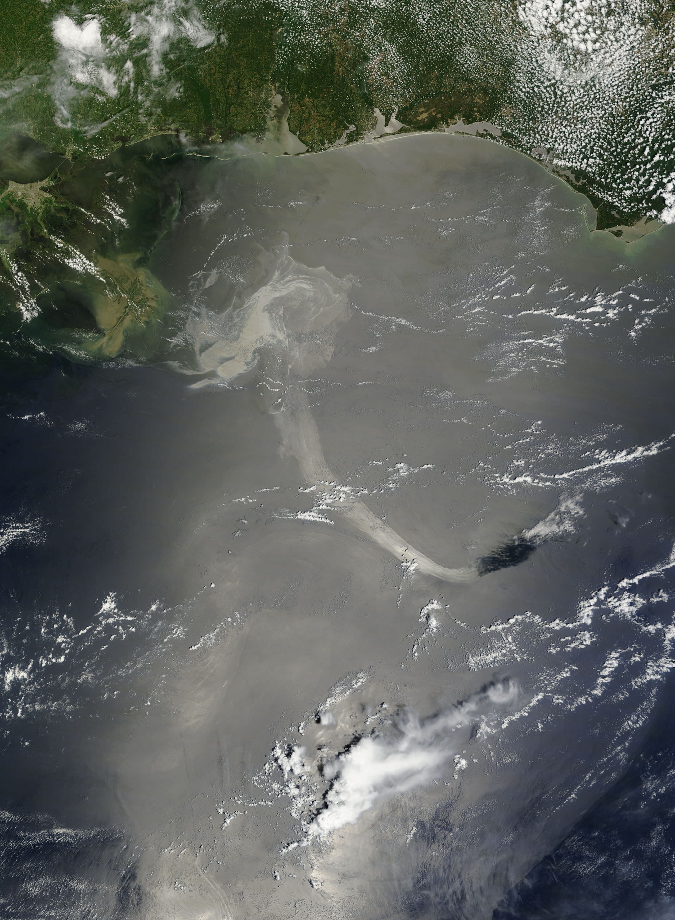
This unusual natural color image taken on May 18, 2010 by the Moderate Resolution Imaging Spectroradiometer (MODIS) on NASA’s Aqua satellite shows sun glinting off the oil slick. The diagonal stripes result from the Sun’s reflection on the ocean surface, called sunglint. The sunglint accentuates the left-to-right scans that the satellite sensor makes as it passes over the Earth’s surface, and the stripes are perpendicular to the satellite’s path.

Besides hinting at the sensor’s scans, the sunglint also illuminates oil slicks on the sea surface. Bright oil slicks appear east and southeast of the delta.

NASA’s and ESA’s satellites will keep watch on this oil slick from above.

Sources: NASA Earth Observatory, (this page, and this page, too), ESA

NASA Technology Helping in Oil Spill Response

An advanced optical sensor built by the Jet Propulsion Lab is flying aboard a NASA research aircraft to help monitor the spread and impact of the Deepwater Horizon BP oil spill in the Gulf of Mexico via remote sensing. The Earth Resources-2 (ER-2) is outfitted with JPL’s Airborne Visible/Infrared Imaging Spectrometer (AVIRIS) and the Cirrus Digital Camera System and can collect detailed images of the Gulf of Mexico and its threatened coastal wetlands. NASA is also making extra satellite observations and conducting additional data processing to assist in monitoring the spill.
Continue reading “NASA Technology Helping in Oil Spill Response”

Latest Satellite Images of Oil Spill

Satellite image from the Aqua Satellite on May 4, 2010 showing the oil spill in the Gulf of Mexico. Credit: NASA/Goddard/MODIS Rapid Response Team

[/caption]

NASA’s Aqua satellite flew over the oil slick in the Gulf of Mexico on May 4, at 18:50 UTC, or 2:50 p.m. EDT, and the Moderate Imaging Spectroradiometer, or MODIS, instrument captured this visible-light image. The bulk of the spill appears as a dull gray area southeast of the Mississippi Delta. The spill is the result of an explosion on April 20, 2010 which destroyed the Deepwater Horizon oil platform operating in the Gulf 80 kilometers (50 miles) offshore. Many of the workers on the platform were killed, and about 5,000 barrels of oil per day has been released into the water. The huge oil slick is being carried towards the Mississippi River Delta. Weather and currents have cooperated so far to keep the slick away from sensitive wetlands and wildlife areas along the Gulf Coast, and oil has come ashore in a few spots in Louisiana. However, the oil is expected to reach the Louisiana, Alabama, and Mississippi shores by Thursday, May 6, and cause considerable damage to property and endanger wildlife and habitats.

See more images below, including one from the International Space Station taken today.

The oil spill as seen from the International Space Station by astronaut Soichi Noguchi. Credit: NASA/JAXA/Noguchi

This image was taken on May 5 by astronaut Soichi Noguchi on board the ISS, and posted on Twitter.

A Envisat Advanced Synthetic Aperture Radar (ASAR) image from May 2, 2010. Credit: CLS

This image from ESA’s Envisat radar, shows sea surface roughness and current flow information. Not only could the slick head towards the US mainland, but there have been fears that the Loop Current in the Gulf of Mexico could catch the oil slick and drag it south towards coral reefs in the Florida Keys. If that were to happen, the oil could flow into the Gulf Stream and be carried up to the US East Coast.

But so far, the loop does not appear to be catching the oil slick.

The Deepwater Horizon oil spill (appearing as a dull gray color) is southeast of the Mississippi Delta in this May 1, 2010, image from NASA's MODIS instrument. Credit: NASA/Goddard/MODIS Rapid Response Team

Another MODIS image from May 1 shows the oil slick as a tangle of dull gray on the ocean surface, made visible to the satellite sensor by the sun’s reflection on the ocean surface. At this point, the oil slick was southeast of the Mississippi Delta.

Close-up view of the oil spill from the ASTER satellite from May 3, 2010. A new NASA satellite image shows the extent of the growing oil spill in the Gulf of Mexico. Image credit: NASA/GSFC/METI/ERSDAC/JAROS, and U.S./Japan ASTER Science Team

The Advanced Spaceborne Thermal Emission and Reflection Radiometer (ASTER) instrument on NASA’s Terra spacecraft captured this image of the growing oil spill in the Gulf of Mexico on May 1, 2010. The image is located at 29.0 degrees north latitude, 88.3 degrees west longitude and covers an area measuring 79.1 by 103.9 kilometers (49 by 64.4 miles), about 32 kilometers (20 miles) west of the mouth of the Mississippi River delta. No land is visible in the image.

The varying shades of white in the image reflect different thicknesses of oil (the whiter, the thicker the oil). The source of the oil spill is visible as the bright white area in the bottom center of the image. The thickest part of the spill extends vertically from it, appearing somewhat like the ash plume of an erupting volcano. The wispy patterns of the oil spill reflect the transport of the oil by waves and currents.

A wide angle view of the oil slick on April 29, 2010. Credit: NASA/Earth Observatory/Jesse Allen, using data provided courtesy of the University of Wisconsin’s Space Science and Engineering Center MODIS Direct Broadcast system.

Sources: NASA Earth Observatory, ESA