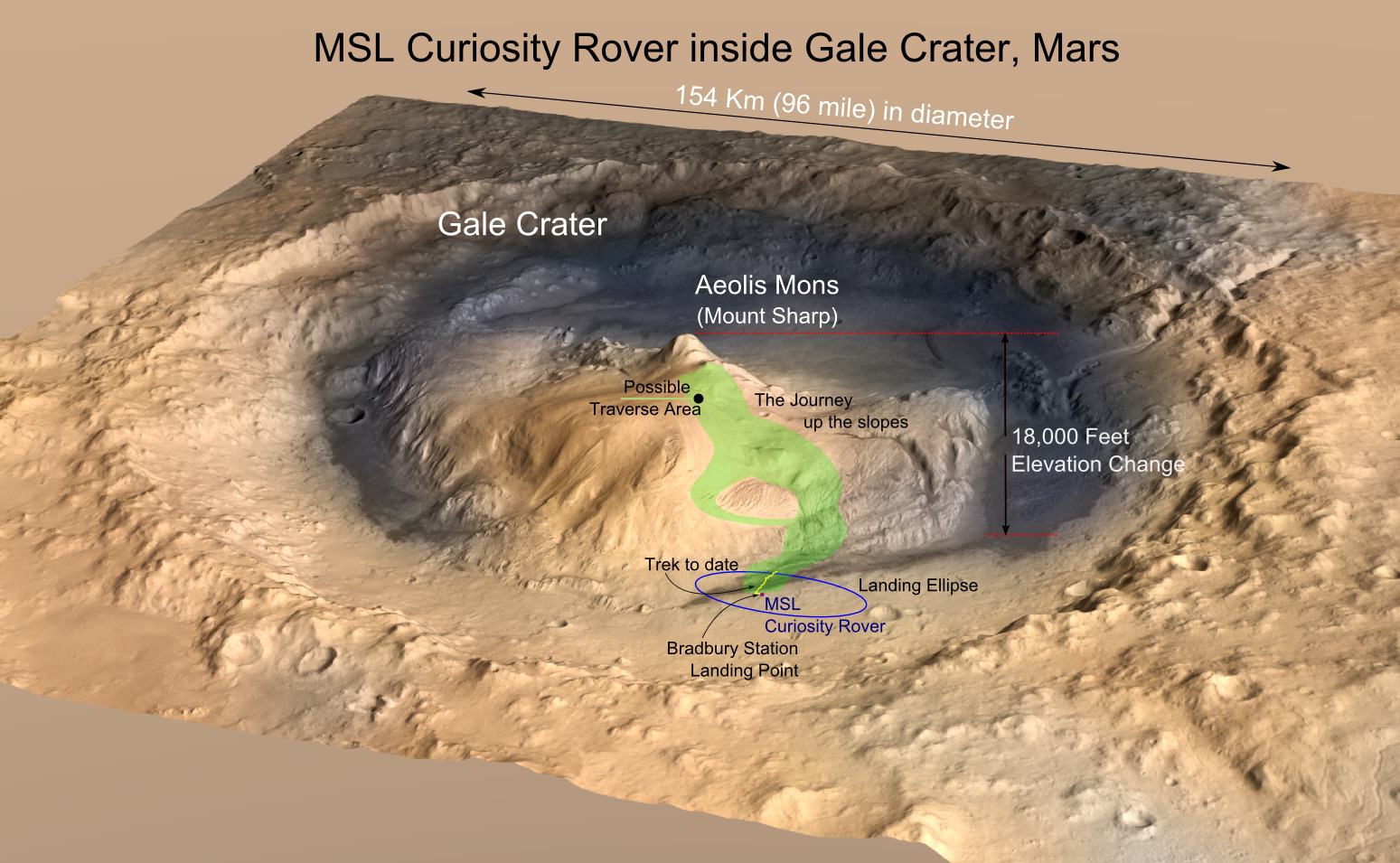
MRO image of Gale Crater illustrating the landing location and trek of the Rover Curiosity. Curiosity's images and data show that the Gale Crater held water for much longer than thought. (Credits: NASA/JPL, illustration, T.Reyes)
Scientists at the Jet Propulsion Laboratory have announced that the Mars Science Lab (MSL), Curiosity Rover, has reached the base of the central peak inside Gale Crater, Aeolis Mons also known as Mount Sharp. Mount Sharp is a prime objective of NASA’s Curiosity journey. The mountain is like a layer cake, holding a chronology of past events, one after the other, stacked upon each other over billions of years. It took two years and one month to reach this present point and what lies ahead is the beginning of an upward trek towards the peak of Mount Sharp, 5500 meters (18,000 feet) above the floor of Gale Crater. However, it is worth a look back and to consider what Mount Sharp represents to the mission.
For over 17 years, NASA robotic spacecraft have maintained a constant presence above or upon the surface of Mars. The Mars Pathfinder mission arrived on July 4, 1997, then quickly followed by Mars Global Surveyor on September 11 and since this time, there has always been at least one active Mars mission.
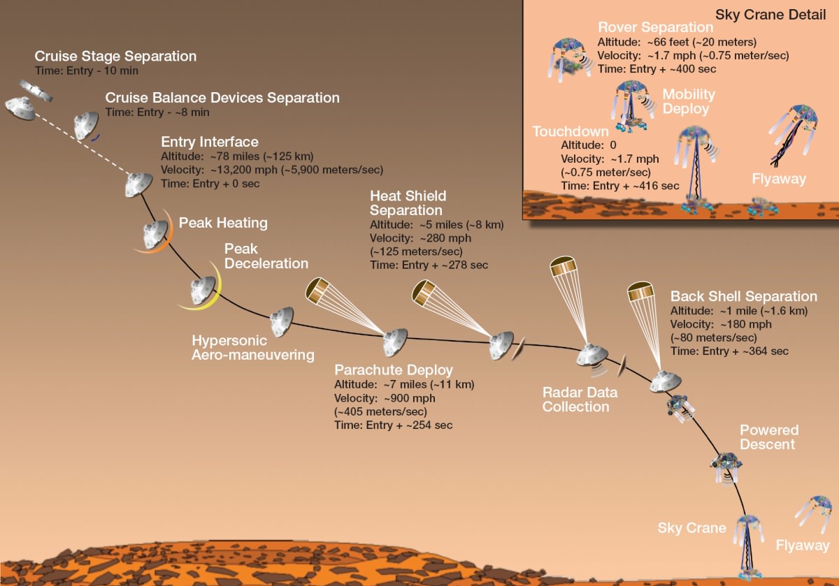
“Seven Minutes of Terror” – the Entry, Descent and Landing (EDL) of the Mars Science Lab (MSL) – Mars Curiosity Rover. (Credit: NASA/JPL)
On November 26, 2011, the voyage of Mars Curiosity Rover began as a trek across 320 million kilometers (200 million miles) of the inner Solar System and culminated in the coined “Seven Minutes of Terror”. For seven long minutes, the MSL, the Mars Curiosity Rover, plowed straight into the Martian atmosphere – the entry, deployed a parachute – the descent, to slow down to about 320 km/hour (200 mph) then the Sky Crane with Rover under foot was released – the landing. With only seconds before an imminent hard impact, the Sky Crane hit the breaks, firing its rockets, then released Curiosity Rover on a tether. This was the Entry, Descent and Landing (EDL). All the while, it was the computer inside the Rover in control. When the tether was cut, the Sky Crane was forced to switch to a simpler processor within its system to complete a final scuttling of itself a few hundred meters away.
The Sky Crane gently lowered Curiosity to the landing point, christened Bradbury Station after the celebrated science fiction writer, Ray Bradbury, writer of the Martian Chronicles(c.1950), who passed away at age 91, 61 days before the landing on August 5, 2012. (recommended video – R. Bradbury reading “If Only We had been Taller” at the public event marking the arrival of Mariner 9 at Mars, November 12, 1971)
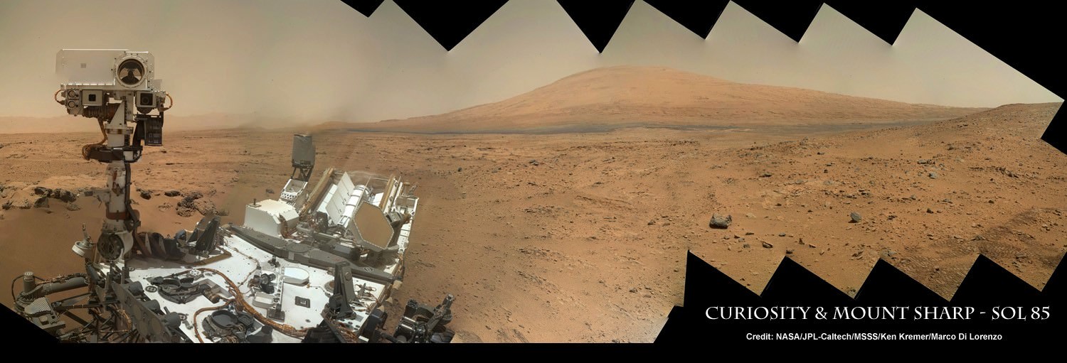
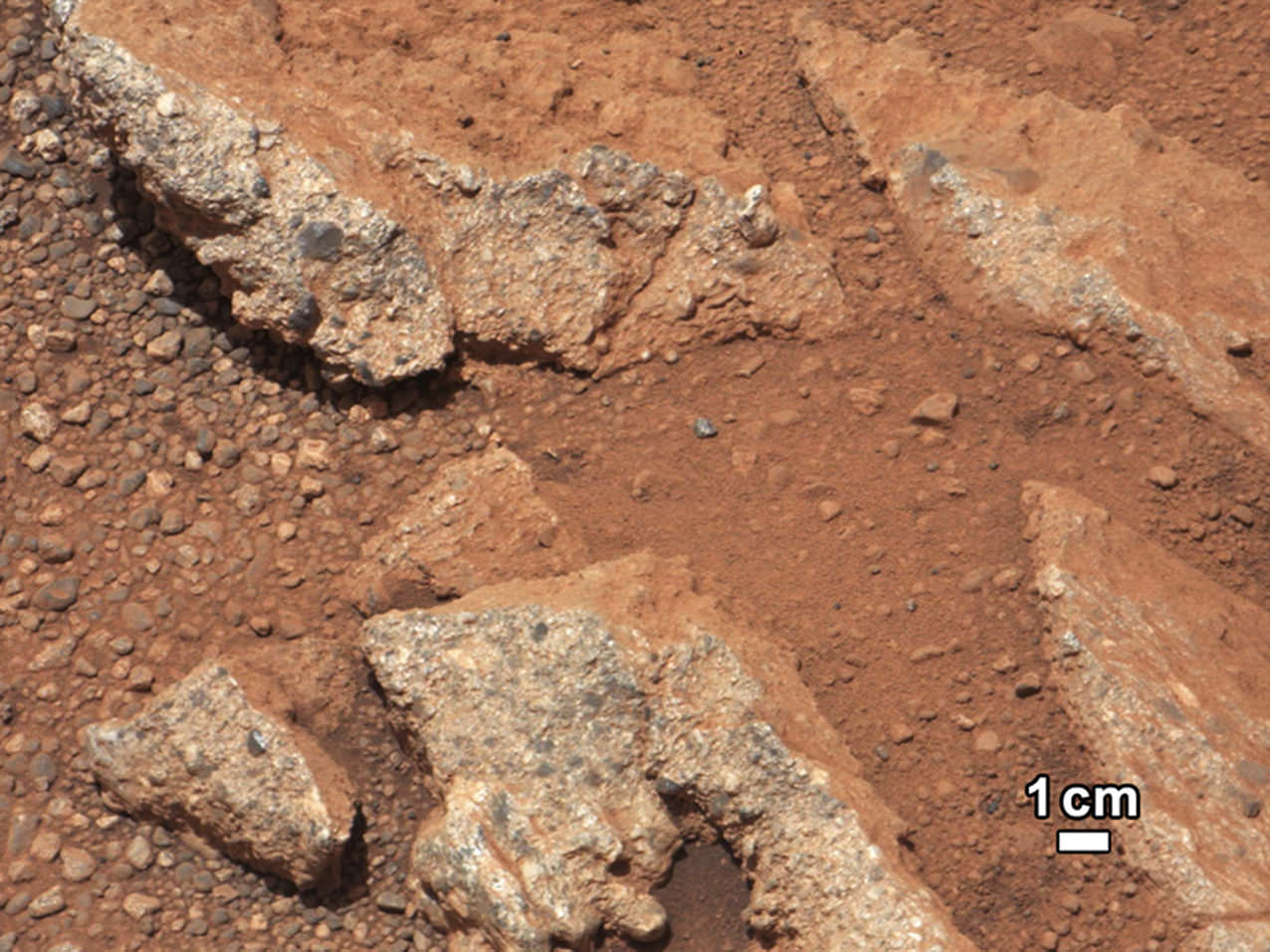
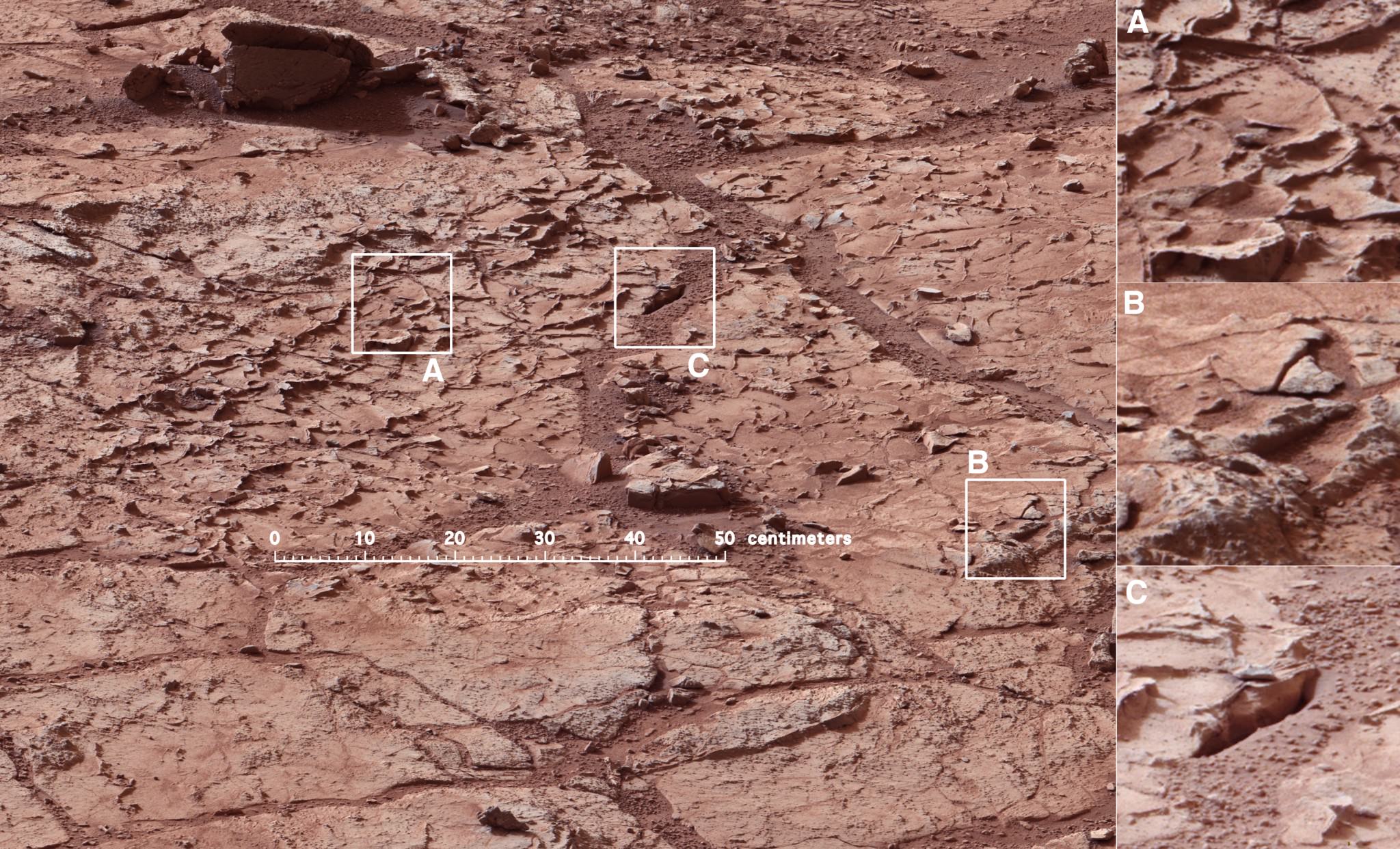
The ultimate Selfie – a self-protrait taken on anoher planet. This is the capability of the Mars Hand Lens Imager (MAHLI) camera, one of 5 instruments on the turret at the end of the 2.1 meter (7 ft), 30 kg (66 lb) Robotic Arm. On numerous occasions, Curiosity has taken self-portraits, many as mosaics. This on is on Sol (Mars day) 85, post landing, showing Curiosity with its destination – Aeolis Mons (Mt. Sharp) in the background. (Credit: NASA/JPL-Caltech/MSSS/Ken Kremer/Marco Di Lorenzo, “Curiosity Celebrates 90 Sols Scooping Mars and Snapping Amazing Self-Portrait with Mount Sharp“)September 27, 2012: A rock outcrop called Link pops out from a Martian surface taken by the 100-millimeter Mast Camera on NASA’s Curiosity Mars rover September 2, 2012. Rounded gravel fragments, or clasts, up to a couple inches (few centimeters) in size are in a matrix of white material. The outcrop characteristics are consistent with a sedimentary conglomerate, or a rock that was formed by the deposition of water and is composed of many smaller rounded rocks cemented together. Scientists enhanced the color in this version to show the Martian scene as it would appear under the lighting conditions we have on Earth, which helps in analyzing the terrain. (NASA/JPL-Caltech/MSSS/Handout/Reuters)Mars Curiosity at the “John Klein” site in Yellow Knife Bay on January 10, 2013 (Mars Sol 153). The Mastcam mosaic was taken from 5 meters (16 ft). The area is full of fractures and veins with intervening rock with concretions (small spherical concentrations of minerals). The enlargements show particular areas of interest. (A) Ridge-like veins protruding from the surface. (B) Shows discontinuities in the veins that likely extend beneath the surface. (C) Shows a hole developed in the sand that overlies a fracture, implying infiltration of sand down into the fracture system. To this author, the area around (A) seems similar to the remnants of dried mud chips or scales one finds in the dry areas of estuaries on Earth. (Credits: NASA/JPL)
What has followed in the last 25 months since the landing is simply staggering. Mars Curiosity Rover, with the most advanced array of instruments and tools ever delivered to a celestial body, has already delivered an immense trove of images and scientific data that is improving and changing our understanding of Mars.
HIRISE images from the orbiting MRO spacecraft are used to show the old and new routes of NASA’s Mars Curiosity rover. The new route provides excellent access to many features in the Murray Formation. And it will eventually pass by the Murray Formation’s namesake, Murray Buttes, previously considered to be the entry point to Mt. Sharp. (Credit: NASA/JPL-Caltech/Univ. of Arizona)
Curiosity had been making progress towards an entry point to Mount Sharp called Murray Buttes, however, because of challenges that the terrain posed – sand dunes and treacherous rocks, they have chosen to enter at Pahrump Hills. Furthermore, the new entry to the lower slopes of Mount Sharp are considered scientifically more interesting. The boundary between the mountain and the crater-floor deposits is not an exact one but NASA scientists explained the reason for the announcement at this point:
“Both entry points lay along a boundary where the southern base layer of the mountain meets crater-floor deposits washed down from the crater’s northern rim.” The terrain is now primarily material from the mountain from here on upward.
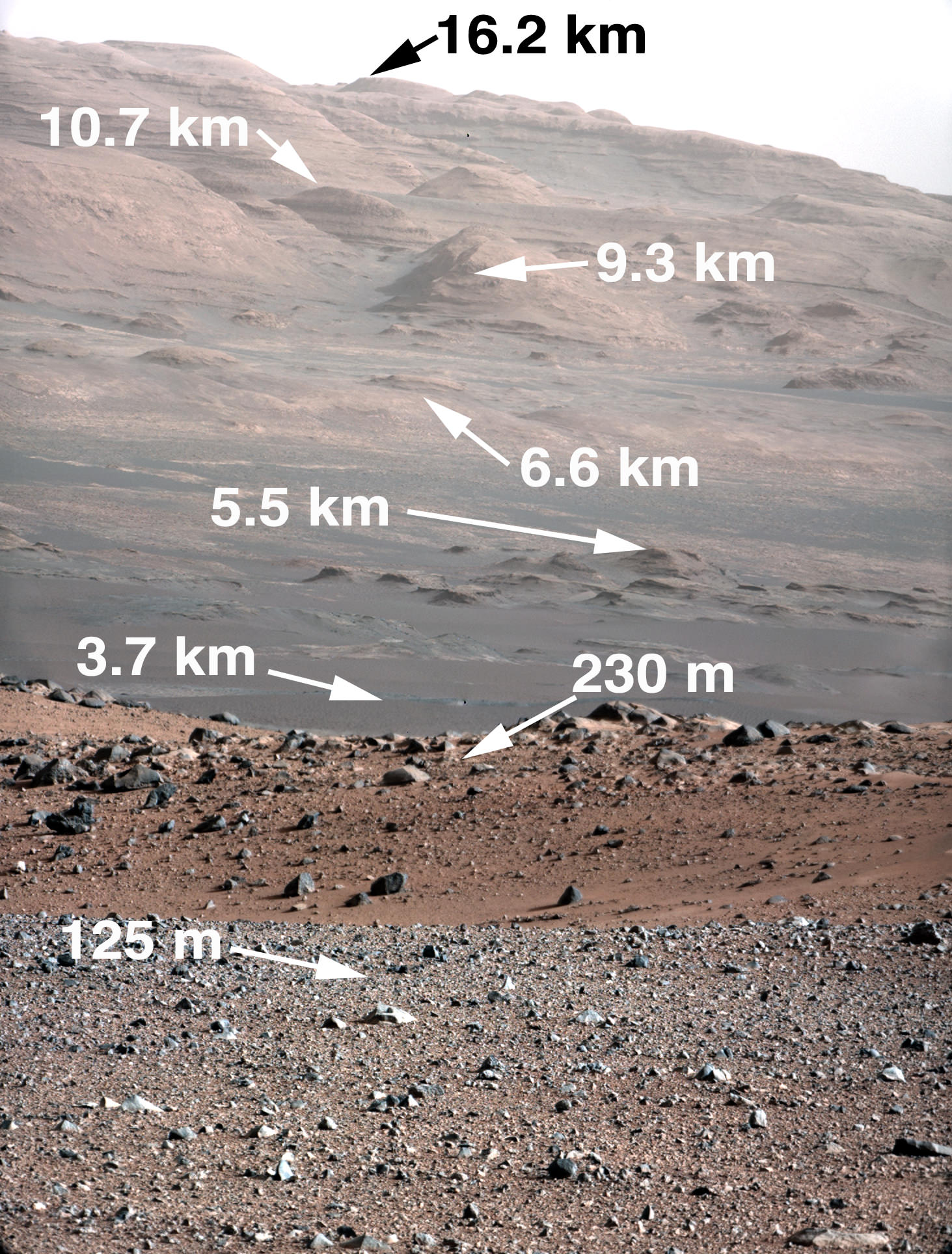
Image taken by the MastCam of Curiosity Rover on August 23, 2012 which shows the buttes representing the base of Mount Sharp, including Murray Buttes. Today, two years later, Mars Curiosity now stands at entry points in the region of the buttes at 6.6 km (direct line distance). In the middle of the image is the boulder-strewn area in which much of Curiosity’s wheel damage occurred. At top are the expansive series of sendiments that is the great interest of Mars researchers. (Credit: NASA/JPL)
Mount Sharp is anything but the normal central peak of an impact crater. Gale crater at 154 km (96 miles) in diameter is what is called a complex crater. Beyond a certain size, depending on the gravity of the planet, craters will have a central peak. It is similar to the spike of water which is thrust upwards when you drop an object into a pool of water. Like the spike of water, an impact, thrusts regolith upwards and it collapses and coalesces into a central peak. However, with Mount Sharp there is something more. If the peak was nothing but a central impact peak, NASA with Mars Curiosity would not be trekking inside Gale Crater.
As data and analysis has accumulated from not just Mars Curiosity Rover but rather from all the active Mars missions, the models and hypotheses describing the structure and morphology on Mars have become more complex. This model and explanation of how Mount Sharp built up over billions of years uses deposition of ice and dust. Click to enlarge and review the five steps to making a layer cake mountain – Mount Sharp. (Credit: Illustration presented by Paul Niles (NASA Johnson Space Center) and Joseph Michalski (Planetary Science Insitute, UK)at the 43rd Lunar and Planetary Science Conference, The Woodlands, Texas)
Mars scientists believe that Gale crater after its creation was completely filled with sedimentary material from a series of huge floods passing over the surrounding terrain or by dust and ice deposits such as happened at the Martian polar caps. The deposition over 2 billion years left a series sedimentary layers that filled the crater.
Following the deposition of the layers, there was a long period of erosion which has finally led to the condition of the crater today. The erosion by some combination of aeolean (wind) forces and water (additional flooding), scooped out the huge crater, re-exposing most of the original depth. However, covering the original central peak are many sedimentary layers of debris. Gale crater’s original central peak actually remains completely hidden and covered by sedimentation. This is what has attracted scientists with Curiosity to the base of Mount Sharp.
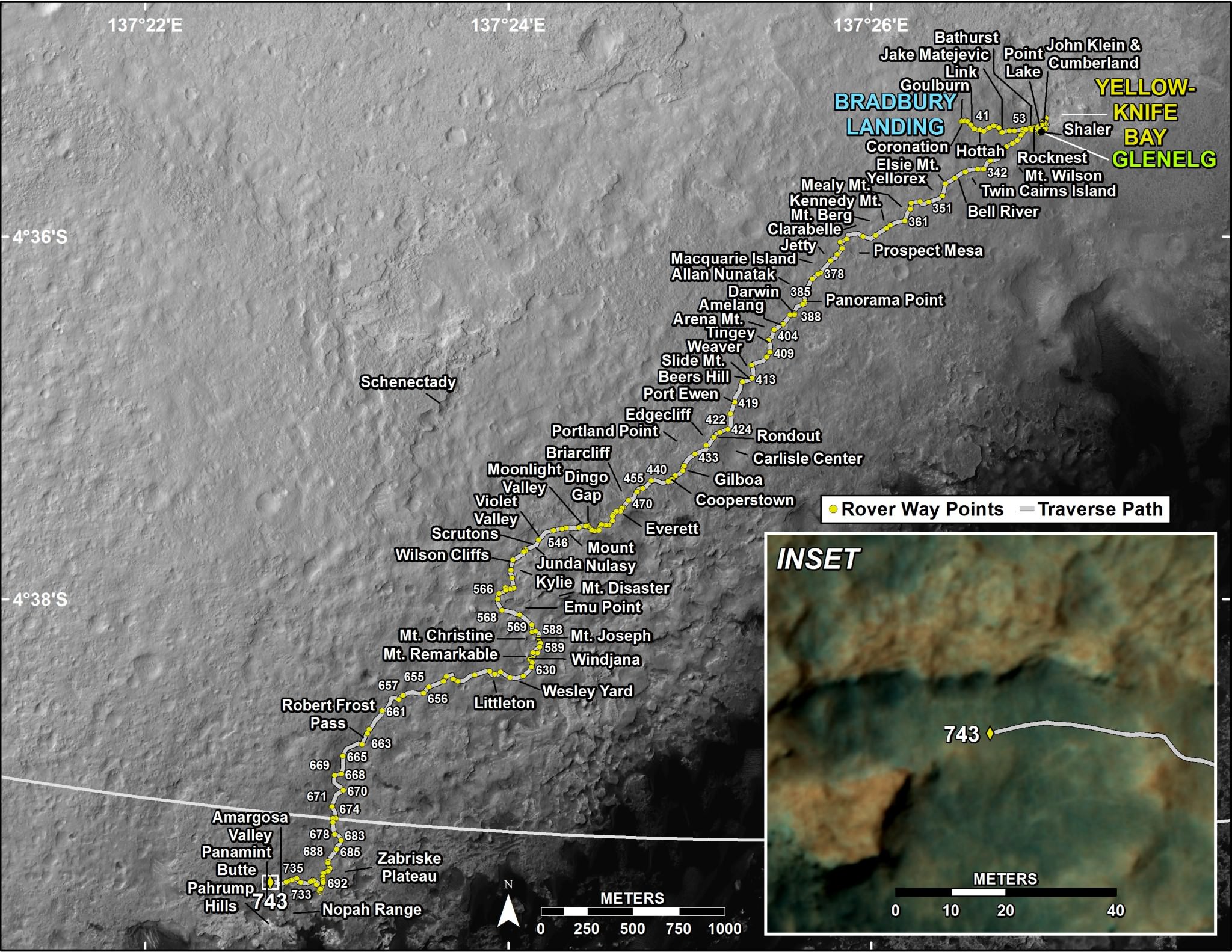
The trek of NASA’s Curiosity Rover from Bradbury Station (landing site, Sol 1) up to Martian Sol 743. The announcement that Curiosity had reached the base of Mt. Sharp is Sol 746. On Martian Sol 675, the Rover took its first step beyond its landing ellipse. (Credit: NASA/JPL)
Within the sedimentary layers covering Mount Sharp, there is a sequential record of the events that laid down the layers. Embedded in each of those layers is a record of the environmental conditions on Mars going back over 2 billion years. At the base are the oldest sedimentary layers and as Curiosity climbs the flanks of the mountain, it will step forward in time. The advanced instrumentation residing on and inside Curiosity will be able to analyze each layer for material content and also determine its age. Each layer and its age will reveal information such as how much water was present, whether the water was alkaline or acidic, if there is any organic compounds. The discovery of organic compounds on Mount Sharp could be, well, Earth shaking. There are organic compounds and then there are organic compounds that are linked to life and this search for organics is of very high importance to this mission.
Already, over the two year trek, Curiosity has seen numerous signs of the flow of water and sedimentation. At its first major waypoint, Glenelg, Curiosity stepped into an area called Yellow Knife Bay that showed numerous signs of past water. There were veins of magnesium salt deposits embedded in the soil, sedimentation and even conglomerate rock such as that found in river beds.
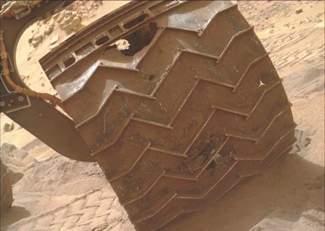
In late 2013, wear and tear accelerated on Curiosity’s wheels, the result of crossing boulder-strewn terrain. Clearly signs of punctures, tears and dents are seen in the photo taken by Curiosity performing a self-inspection. While it certainly raised alarm, mission planners remain confident that it can be handled and will not limit the duration of the mission.(Credits: NASA/JPL)
There is another side to the terrain that Curiosity is traversing. The crater floor, essentially a flood plain has been particularly hard on the mobility system of Curiosity. This is to say that the sharp rocks it continues to encounter under foot are taking a toll on the wheels. Curiosity is now being operated in reverse in order to reduced the impact forces on its wheels.
Furthermore, while scientists are helping to choose the path of the rover, the Curiosity drivers who must assess the field ahead must find paths with fewer sharp rocks in order to slow the damage being done. The Mars Curiosity team is concerned but remain confident that the mobility system will be capable of surviving the ten year life span of the rover’s power supply. So, the momentous occasion is hardly a time to pause and reflect, the trek moves upward, northward to see what the layers on Mount Sharp will reveal.
There are competing hypotheses on how Mount Sharp evolved. Here are two worthy web pages with additional reading.
A portion of a panorama based on pictures taken by the Mars Curiosity rover on Sol 739 in September 2014. Credit: Andrew Bodrov/NASA/JPL-Caltech
Hey, it’s Mars in your browser! Panning around this scene that the Mars Curiosity rover captured earlier this month is the next best thing to being on the Red Planet.
Close by the rover’s is the terrain that proved far more challenging for mission planners than anticipated, and further in the distance you can see mountains — including the ultimate destination for this mission, Mount Sharp (Aeolis Mons).
The panorama, done by Andrew Bodrov, is based on pictures that Curiosity took during Sol 739 of its mission on Mars, which began in August 2012.
The Curiosity mission recently drew the concern of a NASA Senior Review panel, which said that the mission may be moving too fast to Mount Sharp and sacrificing looking carefully at other sites that could preserve signs of habitability.
The rover recently passed over a drilling target due to the nature of the rocks it was looking at, which were loose, unstable and at risk to the rover if they moved in an unpredictable way.
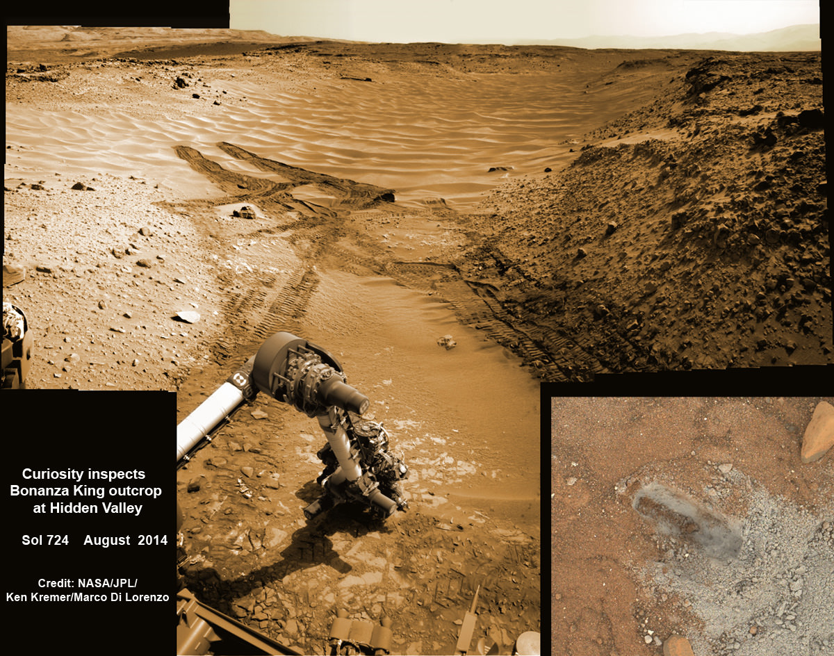
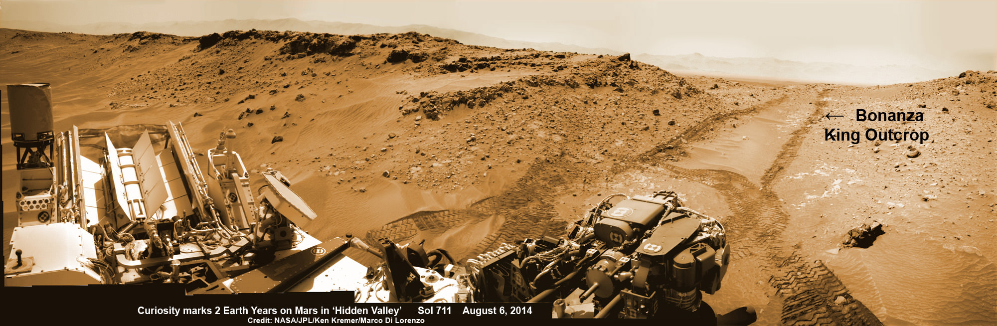
NASA’s Curiosity rover hammers into ‘Bonanza King’ rock outcrop evaluating potential as 4th drill site for sampling at ‘Hidden Valley’ in this photo mosaic view captured on Aug. 20, 2014, Sol 724. Inset MAHLI camera image at right shows resulting rock indentation that caused it to budge and be unsafe for further drilling. Note the background of treacherous sand dune ripples and deep wheel tracks inside Hidden Valley that forced quick exit to alternate route forward. Navcam camera raw images stitched and colorized. Credit: NASA/JPL-Caltech/MSSS/Ken Kremer-kenkremer.com/Marco Di Lorenzo
NASA’s Curiosity rover will skip drilling into a possible 4th rock target and instead resume the trek to Mount Sharp after finding it was unfortunately a slippery rock at the edge of a Martian valley of slippery sands and was therefore too risky to proceed with deep drilling and interior sampling for chemical analysis.
After pounding into the “Bonanza King” rock outcrop on Wednesday, Aug. 20, to evaluate its potential as Curiosity’s 4th drill target on Mars and seeing that it moved on impact, the team decided it was not even safe enough to continue with the preliminary ‘mini-drill’ operation that day.
So they cancelled the entire drill campaign at “Bonanza King” and decided to set the rover loose to drive onwards to her mountain climbing destination.
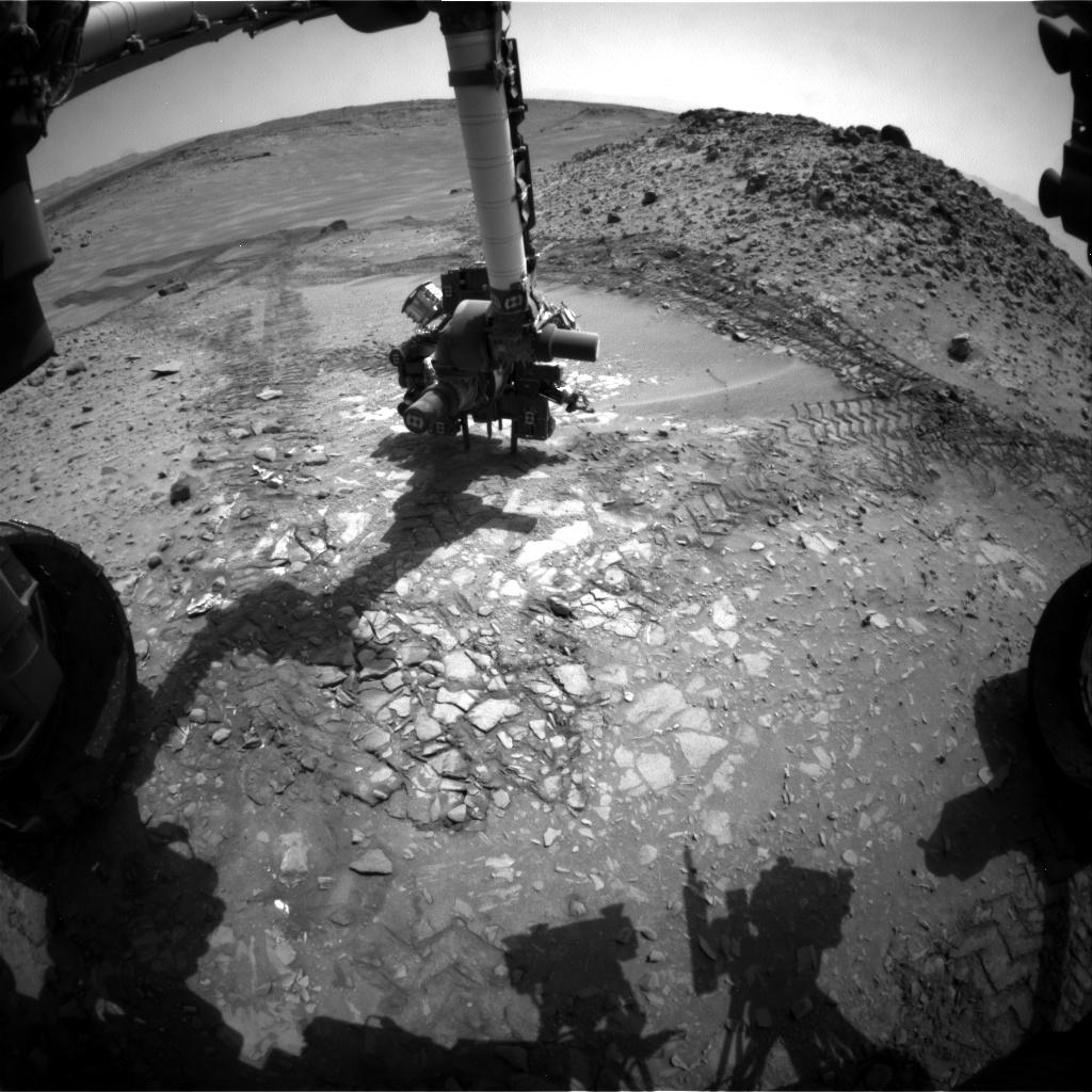
This image from the front Hazcam on NASA’s Curiosity Mars rover shows the rover’s drill in place during a test of whether the rock beneath it, “Bonanza King,” would be an acceptable target for drilling to collect a sample. Subsequent analysis showed the rock budged during the Aug. 19, 2014, test. Credit: NASA/JPL-Caltech
“We have decided that the rocks under consideration for drilling, based on the tests we did, are not good candidates for drilling,” said Curiosity Project Manager Jim Erickson of NASA’s Jet Propulsion Laboratory, Pasadena, California, in a statement.
“Instead of drilling here, we will resume driving toward Mount Sharp.”
Bonanza King was an enticing target because the outcrop possessed thin, white, cross-cutting mineral veins which could indicate that liquid water flowed here in the distant past. Water is a prerequisite for life as we know it.
Loose, unstable rocks pose a prospective hazard to the 1 ton robots hardware and health if they become dislodged during impact by the percussive drill located at the end of the robotic arm.
It’s worth recalling that whirling rocks during the nailbiting Red Planet touchdown two years ago on Aug. 6, 2012, inside Gale Crater are suspected to have slightly damaged Curiosity’s REMS meteorological instrument station.
Each drill target must pass a series of tests. And the prior three at more extensive outcrops all met those criteria. By comparison, imagery showed Bonanza King was clearly part of a much smaller outcrop. See our Bonanza King photo mosaics herein.
NASA’s Curiosity rover looks back to ramp with potential 4th drill site target at ‘Bonanza King’ rock outcrop in ‘Hidden Valley’ in this photo mosaic view captured on Aug. 6, 2014, Sol 711. Inset shows results of brushing on Aug. 17, Sol 722, that revealed gray patch beneath red dust. Note the rover’s partial selfie, valley walls, deep wheel tracks in the sand dunes and distant rim of Gale crater beyond the ramp. Navcam camera raw images stitched and colorized. Credit: NASA/JPL-Caltech/Ken Kremer-kenkremer.com/Marco Di Lorenzo
“One step in the procedure, called “start hole,” uses the hammering action of the percussive drill to create a small indentation in the rock. During this part of the test, the rock moved slightly, the rover sensed that instability in the target, and protective software properly halted the procedure,” according to a NASA statement.
This pale, flat Martian rock thus failed to pass the team’s safety criteria for drilling when it budged.
Bonanza King sits in an bright outcrop on the low ramp at the northeastern end of a spot leading in and out of an area called “Hidden Valley” which lies between Curiosity’s August 2012 landing site in Gale Crater and her ultimate destinations on Mount Sharp which dominates the center of the crater.
Just days ago, the rover team commanded a quick exit from “Hidden Valley” to backtrack out of the dune filled valley because of fears the six wheeled robot could get stuck in slippery sands extending the length of a football field.
“Hidden Valley” looked like it could turn into “Death Valley.”
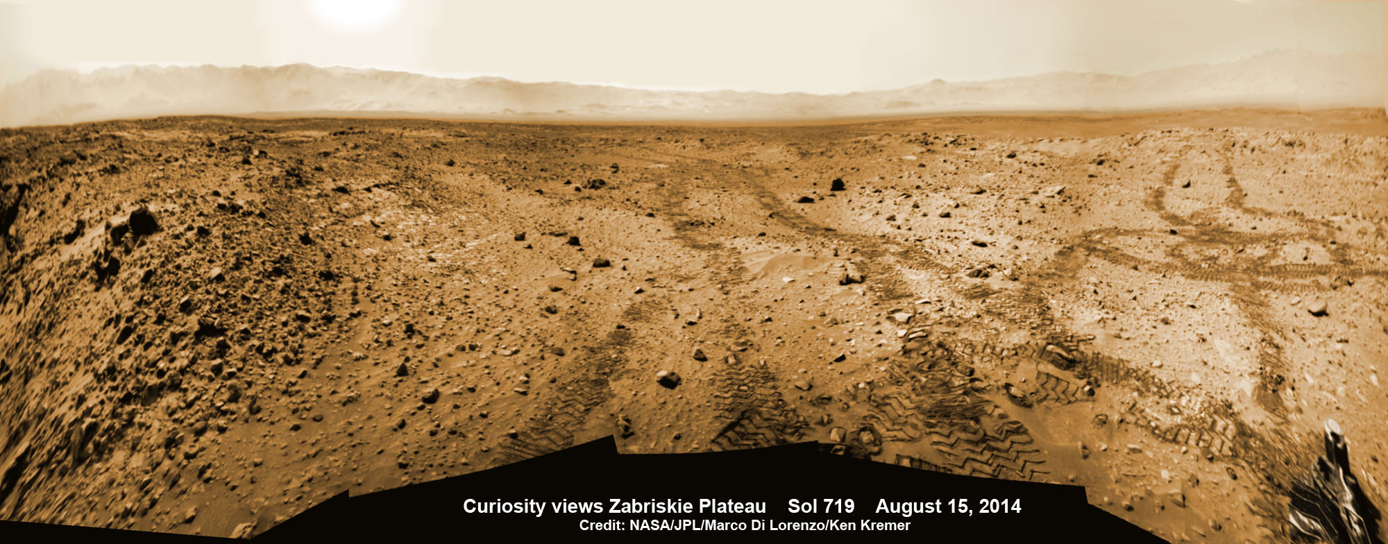
As Curiosity tested the outcrop, the rover team was simultaneously searching for an alternate safe path forward to the sedimentary layers of Mount Sharp because she arrived at Hidden Valley after recently driving over a field of sharp edged rocks in the “Zabriskie Plateau” that caused further rips and tears in the already damaged 20 inch diameter aluminum wheels.
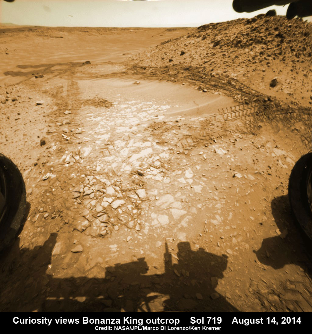
It will take a route skirting the north side of the sandy-floored valley taking care to steer away from the pointiest rocks. Curiosity rover looks back to the rocky plains of the Zabriskie plateau from sandy ramp into ‘Hidden Valley’ with 4th drill site target at ‘Bonanza King’ rock outcrop as shown in this photo mosaic view captured on Aug. 14, 2014, Sol 719. Sharp edged rocks at Zabriskie tore new holes into rover wheels. Navcam camera raw images stitched and colorized. Credit: NASA/JPL-Caltech/Marco Di Lorenzo/Ken Kremer-kenkremer.com
“After further analysis of the sand, Hidden Valley does not appear to be navigable with the desired degree of confidence,” Erickson said. “We will use a route avoiding the worst of the sharp rocks as we drive slightly to the north of Hidden Valley.”
To date, Curiosity’s odometer totals over 5.5 miles (9.0 kilometers) since landing inside Gale Crater on Mars in August 2012. She has taken over 179,000 images.
Curiosity still has about another 2 miles (3 kilometers) to go to reach the entry way at a gap in the treacherous sand dunes at the foothills of Mount Sharp sometime later this year.
Hidden Valley gives a foretaste of the rippely slippery sand dune challenges lurking ahead!
Mount Sharp is a layered mountain that dominates most of Gale Crater and towers 3.4 miles (5.5 kilometers) into the Martian sky and is taller than Mount Rainier.
“Getting to Mount Sharp is the next big step for Curiosity and we expect that in the Fall of this year,” Dr. Jim Green, NASA’s Director of Planetary Sciences at NASA Headquarters, Washington, DC, told me in an interview marking the 2nd anniversary since touchdown on Aug. 6.
“Drilling on the crater floor will provide needed geologic context before Curiosity climbs the mountain.”
The team may go back to its original plan to drill at the potential science destination known as “Pahrump Hills” which was changed due to the route change forced by the slippery sands in Hidden Valley.
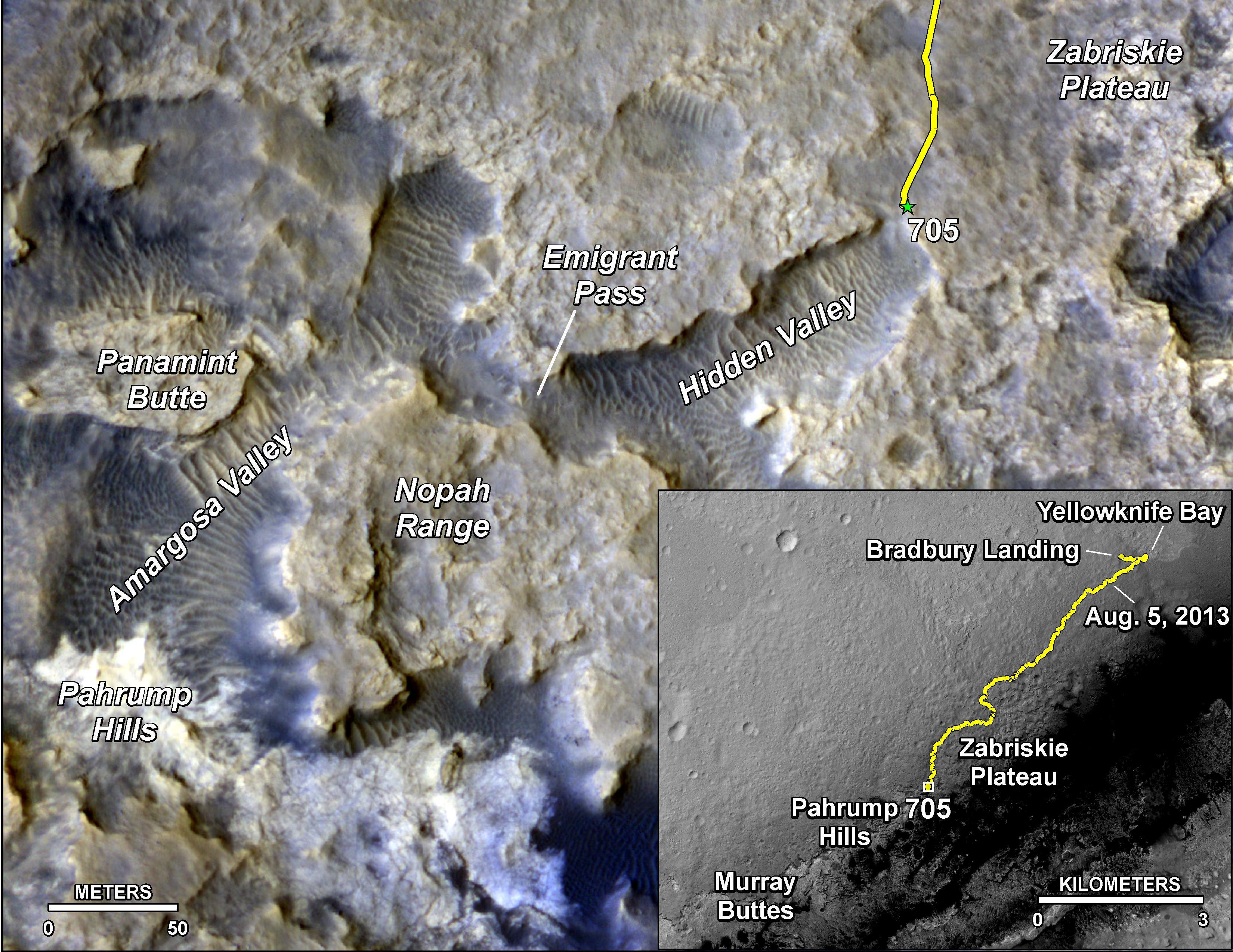
The main map here shows the assortment of landforms near the location of NASA’s Curiosity Mars rover as the rover’s second anniversary of landing on Mars nears. The gold traverse line entering from upper right ends at Curiosity’s position as of Sol 705 on Mars (July 31, 2014). The inset map shows the mission’s entire traverse from the landing on Aug. 5, 2012, PDT (Aug. 6, EDT) to Sol 705, and the remaining distance to long-term science destinations near Murray Buttes, at the base of Mount Sharp. The label “Aug. 5, 2013” indicates where Curiosity was one year after landing. Credit: NASA/JPL-Caltech/Univ. of Arizona
Read an Italian language version of this story by my imaging partner Marco Di Lorenzo – here
Stay tuned here for Ken’s continuing Rosetta, Curiosity, Opportunity, Orion, SpaceX, Boeing, Orbital Sciences, Dream Chaser, commercial space, MAVEN, MOM, Mars and more planetary and human spaceflight news.
Curiosity rover panorama of Mount Sharp captured on June 6, 2014 (Sol 651) during traverse inside Gale Crater. Note rover wheel tracks at left. She will eventually ascend the mountain at the ‘Murray Buttes’ at right later this year. Assembled from Mastcam color camera raw images and stitched by Marco Di Lorenzo and Ken Kremer. Credit: NASA/JPL/MSSS/Marco Di Lorenzo/Ken Kremer-kenkremer.com Up close view of hole in one of rover Curiosity’s six wheels caused by recent driving over rough Martian rocks. Mosaic assembled from Mastcam raw images taken on Dec. 22, 2013 (Sol 490). Credit: NASA/JPL/MSSS/Ken Kremer – kenkremer.com/Marco Di Lorenzo
NASA’s Curiosity rover looks back to ramp with potential 4th drill site target at ‘Bonanza King’ rock outcrop in ‘Hidden Valley’ in this photo mosaic view captured on Aug. 6, 2014, Sol 711. Inset shows results of brushing on Aug. 17, Sol 722, that revealed gray patch beneath red dust. Note the rover’s partial selfie, valley walls, deep wheel tracks in the sand dunes and distant rim of Gale crater beyond the ramp. Navcam camera raw images stitched and colorized. Credit: NASA/JPL-Caltech/Ken Kremer-kenkremer.com/Marco Di Lorenzo
Curiosity brushes ‘Bonanza King’ drill target on Mars
NASA’s Curiosity rover looks back to ramp with 4th drill site target at ‘Bonanza King’ rock outcrop in ‘Hidden Valley’ in this photo mosaic view captured on Aug. 6, 2014, Sol 711. Inset shows results of brushing on Aug. 17, Sol 722, that revealed gray patch beneath red dust. Note the rover’s partial selfie, valley walls, deep wheel tracks in the sand dunes and distant rim of Gale crater beyond the ramp. Navcam camera raw images stitched and colorized.
Credit: NASA/JPL-Caltech/Ken Kremer-kenkremer.com/Marco Di Lorenzo[/caption]
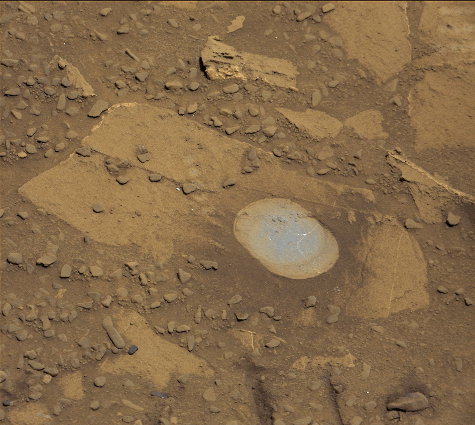
Eagerly eyeing her next drill site on Mars, NASA’s Curiosity rover laid the groundwork by brushing the chosen rock target called ‘Bonanza King’ on Wednesday, Aug. 17, Sol 722, with the Dust Removal Tool (DRT) and collecting high resolution imagery with the Mast Camera (Mastcam) to confirm the success of the operation.
By brushing aside the reddish, more-oxidized dust scientists and engineers leading the mission observed a gray patch of less-oxidized rock material beneath that they anticipated seeing while evaluating the utility of ‘Bonanza King’ as the rover’s fourth candidate for Red Planet rock drilling and sampling.
To date, the 1-ton robot has drilled into three target rocks to collect sample powder for analysis by the rover’s onboard pair of the chemistry labs, SAM and CheMin, to analyze for the chemical ingredients that could support Martian microbes, if they ever existed.
Curiosity rover used the Dust Removal Tool on its robotic arm to brush aside reddish, more-oxidized dust, revealing a gray patch of less-oxidized rock material at a target called “Bonanza King,” visible in this image from the rover’s Mast Camera (Mastcam). Credit: NASA/JPL-Caltech/MSSS
So far everything is proceeding quite well.
The brushing activity also revealed thin, white, cross-cutting veins which is a further indication that liquid water flowed here in the distant past. Water is a prerequisite for life as we know it.
“They might be sulfate salts or another type of mineral that precipitated out of solution and filled fractures in the rock. These thin veins might be related to wider light-toned veins and features in the surrounding rock,” NASA said in a statement.
Based on these results and more from laser zapping with Curiosity’s Chemistry and Camera (ChemCam) instrument on Sol 719 (Aug. 14, 2014) the team decided to proceed ahead.
The imminent next step is to bore a shallow test hole into the brushed area which measures about about 2.5 inches (6 centimeters) across.
If all goes well with the “mini-drill” operation, the team will proceed quickly with full depth drilling to core a sample from the interior of the dinner plate sized rock slab for delivery to Curiosity’s two chemistry labs.
Bonanza King sits in a bright outcrop on the low ramp at the northeastern end of a spot leading in and out of an area called “Hidden Valley” which lies between Curiosity’s August 2012 landing site in Gale Crater and her ultimate destinations on Mount Sharp which dominates the center of the crater.
Just days ago, the rover team commanded a quick exit from “Hidden Valley” to backtrack out of the dune filled valley because of fears the six wheeled robot could get stuck in slippery sands extending the length of a football field.
As Curiosity drills, the rover team is also searching for an alternate safe path forward to the sedimentary layers of Mount Sharp.
To date, Curiosity’s odometer totals over 5.5 miles (9.0 kilometers) since landing inside Gale Crater on Mars in August 2012. She has taken over 178,000 images.
The main map here shows the assortment of landforms near the location of NASA’s Curiosity Mars rover as the rover’s second anniversary of landing on Mars nears. The gold traverse line entering from upper right ends at Curiosity’s position as of Sol 705 on Mars (July 31, 2014). The inset map shows the mission’s entire traverse from the landing on Aug. 5, 2012, PDT (Aug. 6, EDT) to Sol 705, and the remaining distance to long-term science destinations near Murray Buttes, at the base of Mount Sharp. The label “Aug. 5, 2013” indicates where Curiosity was one year after landing. Credit: NASA/JPL-Caltech/Univ. of Arizona
Curiosity still has about another 2 miles (3 kilometers) to go to reach the entry way at a gap in the treacherous sand dunes at the foothills of Mount Sharp sometime later this year.
Mount Sharp is a layered mountain that dominates most of Gale Crater and towers 3.4 miles (5.5 kilometers) into the Martian sky and is taller than Mount Rainier.
“Getting to Mount Sharp is the next big step for Curiosity and we expect that in the Fall of this year,” Dr. Jim Green, NASA’s Director of Planetary Sciences at NASA Headquarters, Washington, DC, told me in an interview making the 2nd anniversary on Aug. 6.
“Drilling on the crater floor will provide needed geologic context before Curiosity climbs the mountain.”
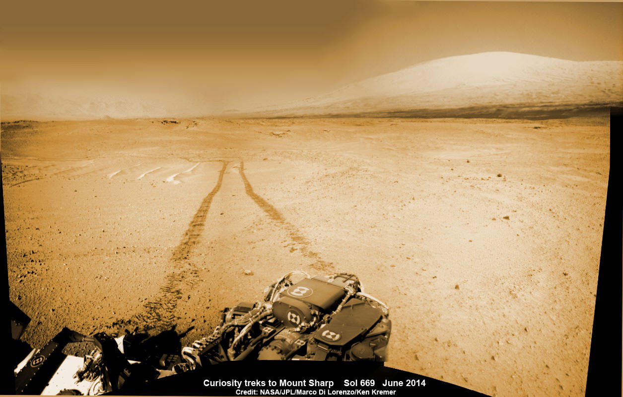
1 Martian Year on Mars! Curiosity treks to Mount Sharp in this photo mosaic view captured on Sol 669, June 24, 2014. Navcam camera raw images stitched and colorized. Credit: NASA/JPL-Caltech/Marco Di Lorenzo/Ken Kremer – kenkremer.com
Read an Italian language version of this story by my imaging partner Marco Di Lorenzo – here
Stay tuned here for Ken’s continuing Rosetta, Curiosity, Opportunity, Orion, SpaceX, Boeing, Orbital Sciences, Dream Chaser, commercial space, MAVEN, MOM, Mars and more planetary and human spaceflight news.
NASA’s Curiosity rover looks back to ramp with 4th drill site target at ‘Bonanza King’ rock outcrop in ‘Hidden Valley’ at site marking her 2nd anniversary on Mars, as shown in this photo mosaic view captured on Aug. 6, 2014, Sol 711. Note the rover’s partial selfie, valley walls, deep wheel tracks in the sand dunes and distant rim of Gale crater beyond the ramp. Navcam camera raw images stitched and colorized. Credit: NASA/JPL-Caltech/Ken Kremer-kenkremer.com/Marco Di Lorenzo
NASA’s Curiosity rover looks back to ramp with 4th drill site target at ‘Bonanza King’ rock outcrop in ‘Hidden Valley’ at site marking her 2nd anniversary on Mars, as shown in this photo mosaic view captured on Aug. 6, 2014, Sol 711. Note the rover’s partial selfie, valley walls, deep wheel tracks in the sand dunes and distant rim of Gale crater beyond the ramp. Navcam camera raw images stitched and colorized.
Credit: NASA/JPL-Caltech/Ken Kremer-kenkremer.com/Marco Di Lorenzo[/caption]
Not wanting to get stuck in a rut, Curiosity’s handlers have commanded NASA’s SUV-sized rover to reverse course and drive out of a potentially hazardous Martian valley of slippery sand with poor wheel traction and instead backtrack towards an enticing nearby spot that the team feels could be the fourth candidate for rock drilling – and thereby widen the scope of the story of habitable environments on the Red Planet.
The new drilling target under up close evaluation right now is named ‘Bonanza King’ – shown in our photo mosaic above.
Bonanza King was chosen after the six wheeled rover unexpectedly experienced significant wheel slippage in the past week while driving over an extended dune field of sandy ripples that basically stopped forward movement inside the Martian valley.
The team was thus in a quandary over whether to push forward on a route through the loose sands of “Hidden Valley” and possibly risk getting mired in a hidden sand trap or drive backwards over a field of sharp rocks on the “Zabriskie plateau” and beyond that are certain to tear further holes in the wheels.
Drilling Candidate Site ‘Bonanza King’ on Mars. This image from the Mast Camera (Mastcam) on NASA’s Curiosity Mars rover shows a portion of the pale rock outcrop that includes the “Bonanza King” target chosen for evaluation as the mission’s fourth rock-drilling site. Raised ridges on the flat rocks — possible mineral veins — are visible at upper and middle right. Tread marks from one of Curiosity’s wheels are visible in the lower half of the image from Sol 707, Aug. 12, 2014. Credit: NASA/JPL-Caltech/MSSS
As reported here last week on the occasion of her 2nd anniversary on Mars since the dramatic touchdown inside Gale Crater on Aug. 6, 2012, Curiosity had been driving merrily through the supposed safe valley of sandy ripples of “Hidden Valley.” She was approaching a bedrock unit named “Pahrump Hills” that for the first time is actually part of the humongous mountain named Mount Sharp she will soon scale and which is the primary science destination of the mission.
But rather soon after driving over a low hump from Zabriskie plateau (see our mosaic below) into Hidden Valley, the robot experienced wheel slippage in the ripples of sand filling the crater floor which was much higher than anticipated. And even worse than comparable test drives in a practice sand lot at JPL.
Curiosity rover looks back to the rocky plains of the Zabriskie plateau from sandy ramp into ‘Hidden Valley’ with 4th drill site target at ‘Bonanza King’ rock outcrop as shown in this photo mosaic view captured on Aug. 14, 2014, Sol 719. Sharp edged rocks at Zabriskie tore new holes into rover wheels. Navcam camera raw images stitched and colorized.
Credit: NASA/JPL-Caltech/Marco Di Lorenzo/Ken Kremer-kenkremer.com
The sandy ripples extend out to the sloping valley walls with no end in sight.
“We need to gain a better understanding of the interaction between the wheels and Martian sand ripples, and Hidden Valley is not a good location for experimenting,” said Curiosity Project Manager Jim Erickson of NASA’s Jet Propulsion Laboratory in Pasadena, California, in a statement.
And since Hidden Valley is as long as a football field and has only two navigable exits at the northeastern and southwestern ends (see map below), the team was forced to drive back to the entrance way at the northern end to consider an alternative route forward to the base of Mount Sharp.
In the meantime while they evaluate the way forward, the team decided that Bonanza King offers similar science to what scientists anticipate at the outcrops at “Pahrump Hills”- a preview of a geological unit that is part of the base of Mount Sharp for the first time since landing rather than still belonging to the floor of Gale Crater.
“Geologically speaking, we can tie the Bonanza King rocks to those at Pahrump Hills. Studying them here will give us a head start in understanding how they fit into the bigger picture of Gale Crater and Mount Sharp,” said Curiosity Deputy Project Scientist Ashwin Vasavada of JPL, in a statement.
Bonanza King sits in an bright outcrop on the low ramp leading in and out of Hidden Valley.
Curiosity rover up close view of ‘Bonanza King’ rock outcrop and 4th drill target looking down from ramp and back into ‘Hidden Valley’ and hazardous dune field of sandy ripples on Aug. 14, 2014, Sol 719. Wheel tracks show where Curiosity drove into the valley, and back out again, earlier in August 2014. The largest of the individual flat rocks in the foreground are a few inches (several centimeters) across. Hazcam camera raw image flattened and colorized. Credit: NASA/JPL-Caltech/Marco Di Lorenzo/Ken Kremer – kenkremer.com
It looks like a pale paving stone. Since its location within the geological layers visible on the ramp is similar to what was expected at the Pahrump Hills outcrop, it’s very appealing to the science team.
Furthermore when one of the rovers wheel’s drove over the outcrop, it cracked open one of the rocks and exposed bright interior material, possibly from mineral veins – which is super exciting from a science perspective as a potential marker for flowing liquid water.
Right now the team is collecting spectral data with the science instruments to assess its science utility and is planning a super fast drilling campaign, far shorter than the prior three.
The plan would be to core a sample from the interior of the dinner plate sized rock slab for delivery to Curiosity’s pair of the onboard chemistry labs, SAM and CheMin to analyze for the chemical ingredients to support miartin microbes, if they ever existed.
“This outcrop on the ramp is too appealing to pass up,” Vasavada said.
The main map here shows the assortment of landforms near the location of NASA’s Curiosity Mars rover as the rover’s second anniversary of landing on Mars nears. The gold traverse line entering from upper right ends at Curiosity’s position as of Sol 705 on Mars (July 31, 2014). The inset map shows the mission’s entire traverse from the landing on Aug. 5, 2012, PDT (Aug. 6, EDT) to Sol 705, and the remaining distance to long-term science destinations near Murray Buttes, at the base of Mount Sharp. The label “Aug. 5, 2013” indicates where Curiosity was one year after landing. Credit: NASA/JPL-Caltech/Univ. of Arizona
To date, Curiosity’s odometer totals over 5.5 miles (9.0 kilometers) since landing inside Gale Crater on Mars in August 2012. She has taken over 178,000 images.
Curiosity still has about another 2 miles (3 kilometers) to go to reach the entry way at a gap in the treacherous sand dunes at the foothills of Mount Sharp sometime later this year.
Mount Sharp is a layered mountain that dominates most of Gale Crater and towers 3.4 miles (5.5 kilometers) into the Martian sky and is taller than Mount Rainier.
“Getting to Mount Sharp is the next big step for Curiosity and we expect that in the Fall of this year,” Dr. Jim Green, NASA’s Director of Planetary Sciences at NASA Headquarters, Washington, DC, told me in an interview making the 2nd anniversary on Aug. 6.
Up close view of hole in one of rover Curiosity’s six wheels caused by driving over rough Martian rocks. Mosaic assembled from Mastcam raw images taken on Dec. 22, 2013 (Sol 490). Credit: NASA/JPL/MSSS/Ken Kremer – kenkremer.com/Marco Di Lorenzo
Stay tuned here for Ken’s continuing Rosetta, Curiosity, Opportunity, Orion, SpaceX, Boeing, Orbital Sciences, Dream Chaser, commercial space, MAVEN, MOM, Mars and more planetary and human spaceflight news.
1 Martian Year on Mars!
Curiosity treks to Mount Sharp in this photo mosaic view captured on Sol 669, June 24, 2014. Navcam camera raw images stitched and colorized. Credit: NASA/JPL-Caltech/Marco Di Lorenzo/Ken Kremer – kenkremer.com2 Earth Years on Mars! NASA’s Curiosity rover celebrated the 2nd anniversary on Mars at ‘Hidden Valley’ as shown in this photo mosaic view captured on Aug. 6, 2014, Sol 711. Note the valley walls, rover tracks and distant crater rim. Navcam camera raw images stitched and colorized. Credit: NASA/JPL-Caltech/Ken Kremer-kenkremer.com/Marco Di Lorenzo