Satellite Captures Unusual “Cloud Streets”

NASA' Terra satellite captured cloud streets in Hudson Bay, Canada on November 20, 2011 at 12:25 p.m. EST (17:25 UTC). Credit: NASA

[/caption]

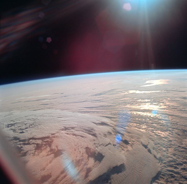
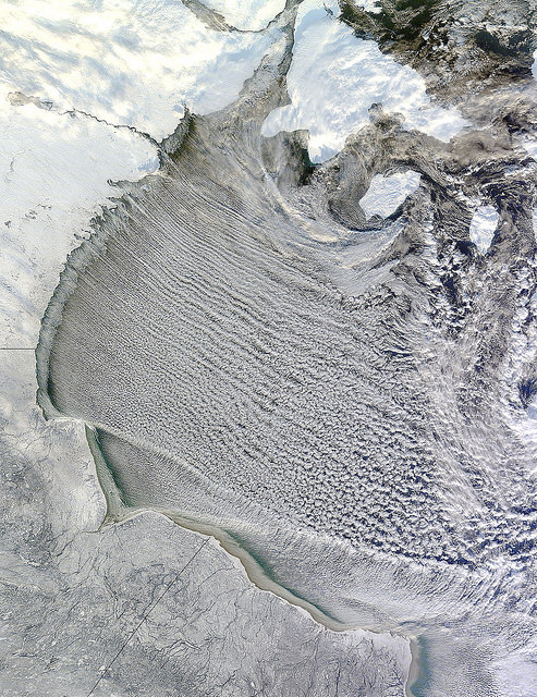
I love looking at unusual cloud formations, and these have to be some of the most intriguing. These long, horizontal rolls of clouds are called “cloud streets” and NASA’s Terra satellite had a “drive by” of these clouds, observing them over Hudson Bay, Canada on November 20, 2011 at 12:25 p.m. EST (17:25 UTC). These rows of clouds stretch from northwest to southeast over the Hudson Bay.

Cloud streets are long lines or bands of cumulus clouds that usually form within the lower one to three kilometers of the atmosphere, and come from eddies in the atmosphere.

According to NASA’s Earth Observatory and the Goddard Space Flight Center Flickr page, cloud streets form when cold air blows over warmer waters, while a warmer air layer—or temperature inversion—rests over top of both. The comparatively warm water of Hudson Bay gives up heat and moisture to the cold air mass above, and columns of heated air—thermals—naturally rise through the atmosphere. As they hit the temperature inversion like a lid, the air rolls over like the circulation in a pot of boiling water. The water in the warm air cools and condenses into flat-bottomed, fluffy-topped cumulus clouds that line up parallel to the wind.

Hudson Bay is a large body of saltwater located in northeastern Canada. Also in the image, are several snow-covered islands in Hudson Bay. The larger island to the north is South Hampton Island, and the smaller island east is Coats Island, and further east is Mansel Island.

Coming Soon – Night Shining Noctilucent Clouds

Noctilucent Cloud Display Credit: Adrian West

[/caption]

Soon you may see an eerie spectacle on clear summer nights if you are located at latitudes between 50° and 70° north and south of the equator: Noctilucent Clouds.

These ghostly apparitions are a delight to see and are quite rare. It is incredibly difficult to predict exactly when they will appear, but we do know they should begin to appear soon.

The season for Noctilucent Clouds (Noctilucent = Latin for “Night Shining”) starts early June and continues into late July. They are seen just after dusk, or before dawn and an apparition can last around an hour.

These mysterious clouds, with their bizarre tenuous wispy shapes reminiscent of ripples in sand or the changing surface of a pool of water, spread like a glowing web across the northern sky. Colours can range from brilliant whites, with tinges of blue, pink and orange.

Formed by tiny ice crystals, they are the highest clouds in the Earth’s atmosphere, located in the mesosphere at altitudes of around 76 to 85 kilometers (47 to 53 miles) almost at the edge of space.

They are normally too faint to be seen, and are visible only when illuminated by sunlight from below the horizon, while the lower layers of the atmosphere are in the Earth’s shadow. Noctilucent clouds are not fully understood and are a recently discovered meteorological phenomenon, only being recorded for about 120 years.

Noctilucent clouds can only form under very restrictive conditions, and their occurrence can be used as a guide to changes in the upper atmosphere. Since their relatively recent classification, the occurrence of noctilucent clouds appears to be increasing in frequency, brightness and extent.

There is evidence that the relatively recent appearance of noctilucent clouds and their gradual increase, may be linked to climate change. Another recent theory is that some of these bright displays come from particulates and water vapour in the atmosphere left over from Space Shuttle launches.

How can you see them? Over the next couple of months look north during dusk and dawn and try and spot this mysterious and elusive phenomenon. They are best seen when the sun is between 6 and 16 degrees below the horizon, and seem to occur more frequently in the Northern hemisphere than the Southern.

Good luck!

Noctilucent clouds over Blair, Nebraska, USA. Credit: Mike Hollingshead

What Are Clouds Made Of?

Clouds

When we think of clouds we think of those white cotton ball masses in the air. What we don’t really think about is what are clouds made of. We all know about the water cycle in some form. We know that clouds are created from the water that evaporates from various lakes, rivers, and oceans. We also know that at some time this evaporated water becomes rain and starts the cycle all over again.

However there are important questions about clouds we overlook. First, how are clouds visible if water vapor is normally supposed to be invisible like air or at least dissipate quickly after the first gush of steam? Second, why do clouds last so long in their different forms? Finally, what gives clouds their white or grey colors? As you can see there is a lot we take for granted in our understanding of clouds and how they are formed.

We know that clouds are made of water vapor, what we don’t know or at least forget is the important role that condensation plays in making clouds visible. For the most part water vapor is invisible. This is proven by the fact that the air we breathe regularly has some water vapor as part of its composition. However we don’t see it since its apart of the air. Condensation is what makes water vapor visible.

Basically high temperatures excite water molecules until they change from a liquid state to a gaseous one. However lower temperatures can cause enough water vapor to condense back into liquid form. This small amount stays as very small droplets that can stay suspended in the air mostly thanks to small dust particles that they attach themselves to.

It is pretty much the same way you see small bits of glitter suspended in clear glue. The drops are small enough to stay trapped in the air until condensation reaches a point of no return making rain. One result of this is that light becomes reflected and refracted. This is what makes clouds visible.

Now if you think about it we also just answered the second question about why clouds last so long. You may understand the first explanation because you can see your breath on a cold day. However after a while depending on the weather you notice that later in the day you can no longer see your breath. Clouds are visible because of colder temperatures in the upper atmosphere.

You have to remember that in the upper reaches of the atmosphere that the temperatures are much colder. This means that water vapor once condensed can no longer return fully to its gas state. Since temperatures don’t change in this region clouds are able to keep shape longer.

Finally, clouds have color. Some are white, some are grey, and in special circumstances such as major storms can have weird colors like green or red. This goes back to refraction. Most color that we can see is visible because are eyes perceive how objects absorb or reflect certain wavelengths of light. The white colors of clouds come from the condensed water vapor having a high reflective quality.

When all wavelengths of light are reflected back you see white. The grey color comes from seeing clouds from beneath. White clouds are white if you notice, on sunny days. This is because you can see the sunlight directly hitting them and see that light almost completely reflected back. On cloudy days most sunlight is blocked by the translucent and refractive quality of cloud cover. This makes clouds appear darker in color as part of the light has been uniformly absorbed.

We have written many articles about clouds for Universe Today. Here’s an article about the types of clouds, and here’s an article about cirrocumulus clouds.

If you’d like more info on clouds, check out an article aboutClouds. And here’s a link to NASA Spaceplace Page about Clouds.

We’ve also recorded an episode of Astronomy Cast all about the Atmosphere. Listen here, Episode 151: Atmospheres.

Cloud Pictures

Mammatus Clouds

Here are some cool cloud pictures.

Here’s a photo of mammatus clouds, taken by NASA. These are a type of cloud associated with thunderstorms and bad weather.

Lenticular Clouds

Here’s a picture of lenticular clouds. This kind of cloud looks lens shaped, and sometimes even like a flying saucer. They form when moist air flows over top of a mountain, creating a series of standing waves in the atmosphere. If the temperature drops below the dew point, lenticular clouds may form.

These are Morning Glory clouds, a very rare type of cloud formation seen in Australia. They look like long lines of rolling clouds moving across the landscape. They can be more than 1,000 km long and 1-2 km high. They move 60 km/h across the landscape. Scientists aren’t really certain how they form.

Cumulus Clouds

Here’s a classic example of a cumulus clouds. These are the common fluffy white clouds we see when warm air rises and the moisture in the air condenses.

Orographic Clouds

This is an image of orographic clouds. These are formed when air masses are forced from low elevation to go over higher terrain like a mountain. As the air gains altitude, expands and cools forming clouds.

We’ve written many articles about clouds for Universe Today. Here’s an article about how clouds are formed, and here’s an article about different types of clouds.

If you’d like more information on clouds, check out NASA’s cloud gallery. And here’s a link to more information on clouds.

We’ve also recorded an episode of Astronomy Cast about atmospheres. Listen here, Episode 151: Atmospheres.

How are Clouds Formed?

Atmospheric Pollution
Particulates from pollution mixing with clouds above the US (NASA)

[/caption]I bet some of you are fascinated with certain cloud formations. My eldest son once pointed to the sky, excited upon seeing a bunch of clouds taking shape of a menacing dragon. He was however disappointed after a few minutes when the dragon cloud slowly began to deform and fuse with the rest. So how are clouds formed?

First, water evaporates, rises, and fills up the atmosphere. The evaporated water, a.k.a. water vapor then clings to other numerous particles or dust found in the atmosphere. This dust comes from automobiles, fires, volcanoes, bacteria, and sea spray.

As water vapor rises, it cools. Now, the lower the temperature of air, its capacity to hold water vapor (also known as the saturation point of air) also drops.

Eventually, the rising water vapor condenses and forms the structure of the cloud. You can’t however see this structure unless it has its own color. Well, we know that clouds are either white or dark, and that’s why we’re able to see them.

Most clouds are white. That’s because water and ice particles that make up a cloud have just the right amount and sizes to scatter light in all possible wavelengths. When light of practically all wavelengths combine, the result is white light.

However, when too many water and ice particles build up, just like in a storm cloud, much of the scattered light is simply re-scattered into the cloud. In other words, too much particles prevent some of the light from escaping. Hence is the reason why storm clouds are dark.

Try slowly adding milk in water and notice how its color slowly shifts from white to dark as more milk is added.

I’m sure you’ve noticed that clouds easily form on mountains. How are clouds formed on mountains? When a wall of air and water vapor encounters a mountain side, it has nowhere else to go but up the slopes. Well, if you recall, rising water vapor cools and eventually condenses to form clouds.

Thus, mountains don’t have special particles that enhance cloud formation. Rather, it is the barriers that they so form that forces the water vapor to rise and hence develop into cloud structures. A cloud formed due to topographical features is called an orographic cloud.

We’ve got lots of articles about clouds here in Universe Today. For starters, here are two:
Cloud Types
Cirrus Clouds

Here are the links of two more articles from National Oceanic and Atmospheric Administration (NOAA):
Cloud Classifications and Characteristics
Western Region Technical Attachment
Here are two episodes at Astronomy Cast that you might want to check out as well:
Orbit of the Planets, Green Stars, and Oort Cloud Contamination
Sky Surveys

What are Cumulonimbus Clouds?

Cumulonimbus clouds. Credit: NASA

Cumulonimbus clouds are a type of cumulus cloud associated with thunder storms and heavy precipitation. They are also a variation of nimbus or precipitation bearing clouds. They are formed beneath 20,000 ft. and are relatively close to the ground. This is why they have so much moisture. Cumulonimbus clouds are also known as thunderheads due to their unique mushroom shape.

These clouds often produce lightning in their heart. This is caused by ionized droplets in the clouds rubbing against each other. The static charge built up create lightning. Cumulonimbus clouds need warm and humid conditions to form. This gives them the moist warm updrafts needed to produce them. In some instances a Thunderhead with enough energy can develop into a supercell which can produce strong winds, flash floods, and a lot of lightning. Some can even become tornadoes given the right conditions.

Despite the heavy rainfall these clouds produce, the precipitation normally just lasts for around 20 minutes. This is because the clouds require not only a lot of energy to form but also expend a lot energy. However, there are exceptions to the rule. There are also dry thunderstorms which are cumulonimbus clouds whose precipitation does not touch the ground. This type is common in the Western United States where the land is more arid. It is often cited as a cause of wild fires.

An overlooked result of Cumulonimbus clouds are flash floods. This was proven recently in Atlanta, Georgia area of the United States. The state had gone through a two year drought and water supplies such as creeks and rivers were low. However the fall season brought with it the end of the drought and a lot of Thunderstorms. Even though Atlanta is not near any major waterways, the resulting flash floods were on a scale seen only with areas near major rivers with wide flood plains. This demonstrates how much precipitation that Cumulonimbus clouds can produce even in a short amount of time.

Cumulonimbus clouds are a perfect example of how difference in altitude can affect the formation of clouds. Cumulonimbus clouds form in the lower part of the troposphere, the layer of the atmosphere closest to the surface of the Earth. This region due to evaporation and the greenhouse effect produces alot of the warm updrafts that make creation of cumulus and cumulonimbus clouds possible. The turbulence created by the friction between air and the surface of the Earth combined with stored heat from the sun helps to drive the majority of weather.

If you enjoyed this article there are others on Universe Today that you will be sure to enjoy. There is a great article on cloud types and another on the composition of the Earth’s atmosphere.

There are also great resources online. USA today has a great article on cloud types. You can also check out the cloud types website for the University of Illinois.

You can also check out Astronomy Cast. Episode 151 is about atmospheres.

Ice Clouds on Mars Create Shade

shadowcloud1_l.thumbnail.jpg

Until now, Mars has generally been regarded as a desert world, where a visiting astronaut would be surprised to see clouds drifting across the orange sky. But new data and images show that Mars does indeed have clouds, and some are actually thick enough to cast a shadow on the planet’s surface. These are clouds of dry ice, or carbon dioxide (CO2), and sometimes they are so large and so dense that they throw quite dark shadows on the dusty surface. This, in turn, can affect the weather patterns on Mars. Researchers also say this discovery could help to understand Mars’ climate history.

Data obtained from ESA’s Mars Express OMEGA Visible and Infrared Mineralogical Mapping Spectrometer instrument has been analyzed by a group of French scientists.

“This is the first time that carbon dioxide ice clouds on Mars have been imaged and identified from above,” said Franck Montmessin of the Service da Aeronomie, University of Versailles. “This is important because the images tell us not only about their shape, but also their size and density.”

Clouds of water ice particles have previously been seen, for example on the sides of the giant Martian volcanoes. There have also been hints of much higher, wispy clouds made up of carbon dioxide (CO2) ice crystals. This is not too surprising, since the thin Martian atmosphere is mostly made of carbon dioxide, and temperatures on the fourth planet from the Sun often plunge well below the ‘freezing point’ of carbon dioxide. But these clouds are not very thick.

But the CO2 clouds detected by OMEGA are very different. Not only are they surprisingly high — more than 80 km above the surface — but they can be several hundred kilometers across. They are also much thicker than expected. Instead of looking like the wispy ice clouds seen on Earth, they resemble tall convectional clouds that grow as the result of rising columns of warm air.

Even more surprising is the fact that the CO2 ice clouds are made of quite large particles – more than a micron (one thousandth of a millimeter) across — and they are sufficiently dense to noticeably dim the Sun. Normally, particles of this size would not be expected to form in the upper atmosphere or to stay aloft for very long before falling back towards the surface.

“The clouds imaged by OMEGA can reduce the Sun’s apparent brightness by up to 40 per cent,” said Montmessin. “This means that they cast quite a dense shadow and this has a noticeable effect on the local ground temperature. Temperatures in the shadow can be up to 10 degrees C cooler than their surroundings, and this in turn modifies the local weather, particularly the winds.”

Since the CO2 clouds are mostly seen in equatorial regions, the OMEGA team believes that the unexpected shape of the clouds and large size of their ice crystals can be explained by the extreme variations in daily temperature that occur near the equator.

“The cold temperatures at night and relatively high day-time temperatures cause large diurnal waves in the atmosphere,” explained Montmessin. “This means there is a potential for large-scale convection, particularly as the morning Sun warms the ground.”

“This discovery is important when we come to consider the past climate of Mars,” Montmessin continued. “The planet seems to have been much warmer billions of years ago, and one theory suggests that Mars was then blanketed with CO2 clouds. We can use our studies of present-day conditions to understand the role that such high level clouds could have played in the global warming of Mars.”

Original News Source: ESA Press Release