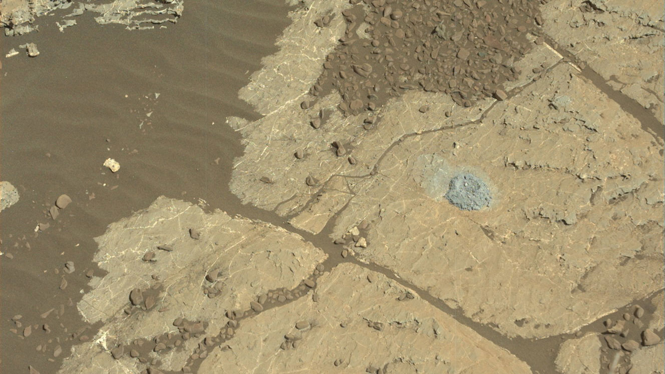
NASA's Curiosity Mars rover used a new drill method to produce a hole on February 26 in a target named Lake Orcadie. The hole marks the first operation of the rover's drill since a motor problem began acting up more than a year ago. Credit: NASA/JPL-Caltech/MSSS
Since it landed on Mars in 2012, the Curiosity rover has used its drill to gather samples from a total of 15 sites. These samples are then deposited into two of Curiosity’s laboratory instruments – the Sample Analysis at Mars (SAM) or the Chemistry and Mineralogy X-ray Diffraction (CheMin) instrument – where they are examined to tell us more about the Red Planet’s history and evolution.
Unfortunately, in December of 2016, a key part of the drill stopped working when a faulty motor prevented the bit from extending and retracting between its two stabilizers. After managing to get the bit to extend after months of work, the Curiosity team has developed a new method for drilling that does not require stabilizers. The new method was recently tested and has been proven to be effective.
The new method involves freehand drilling, where the drill bit remains extended and the entire arm is used to push the drill forward. While this is happening, the rover’s force sensor – which was originally included to stop the rover’s arm if it received a high-force jolt – is used to takes measurements. This prevents the drill bit from drifting sideways and getting stuck in rock, as well as providing the rover with a sense of touch.
NASA’s Curiosity rover raised robotic arm with drill pointed skyward while exploring Vera Rubin Ridge at the base of Mount Sharp inside Gale Crater – backdropped by distant crater rim. Credit: NASA/JPL/Ken Kremer/kenkremer.com/Marco Di Lorenzo
The test drill took place at a site called Lake Orcadie, which is located in the upper Vera Rubin Ridge – where Curiosity is currently located. The resulting hole, which was about 1 cm (half an inch) deep was not enough to produce a scientific sample, but indicated that the new method worked. Compared to the previous method, which was like a drill press, the new method is far more freehand.
“We’re now drilling on Mars more like the way you do at home. Humans are pretty good at re-centering the drill, almost without thinking about it. Programming Curiosity to do this by itself was challenging — especially when it wasn’t designed to do that.”
This new method was the result of months of hard work by JPL engineers, who practiced the technique using their testbed – a near-exact replica of Curiosity. But as Doug Klein of JPL, one of Curiosity’s sampling engineers, indicated, “This is a really good sign for the new drilling method. Next, we have to drill a full-depth hole and demonstrate our new techniques for delivering the sample to Curiosity’s two onboard labs.”
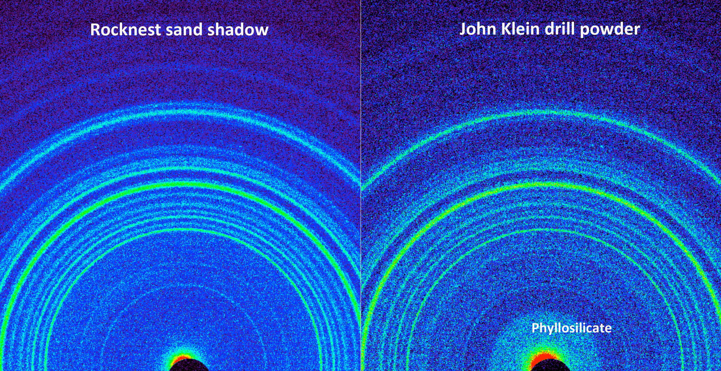
This side-by-side comparison shows the X-ray diffraction patterns of two different samples collected from the Martian surface by NASA’s Curiosity rover, as obtained by Curiosity’s Chemistry and Mineralogy instrument (CheMin). Credit: NASA/JPL-Caltech/Ames
Of course, there are some drawbacks to this new method. For one, leaving the drill in its extended position means that it no longer has access to the device that sieves and portions rock powder before delivering it to the rover’s Collection and Handling for In-Situ Martian Rock Analysis (CHIMRA) instrumet. To address this, the engineers at JPL had to invent a new way to deposit the powder without this device.
Here too, the engineers at JPL tested the method here on Earth. It consists of the drill shaking out the grains from its bit in order to deposit the sand directly in the CHIMRA instrument. While the tests have been successful here on Earth, it remains to be seen if this will work on Mars. Given that both atmospheric conditions and gravity are very different on the Red Planet, it remains to be seen if this will work there.
This drill test was the first of many that are planned. And while this first test didn’t produce a full sample, Curiosity’s science team is confident that this is a positive step towards the resumption of regular drilling. If the method proves effective, the team hopes to collect multiple samples from Vera Rubin Ridge, especially from the upper side. This area contains both gray and red rocks, the latter of which are rich in minerals that form in the presence of water.
Samples drilled from these rocks are expected to shed light on the origin of the ridge and its interaction with water. In the days ahead, Curiosity’s engineers will evaluate the results and likely attempt another drill test nearby. If enough sample is collected, they will use the rover’s Mastcam to attempt to portion the sample out and determine how much powder can be shaken from the drill bit.
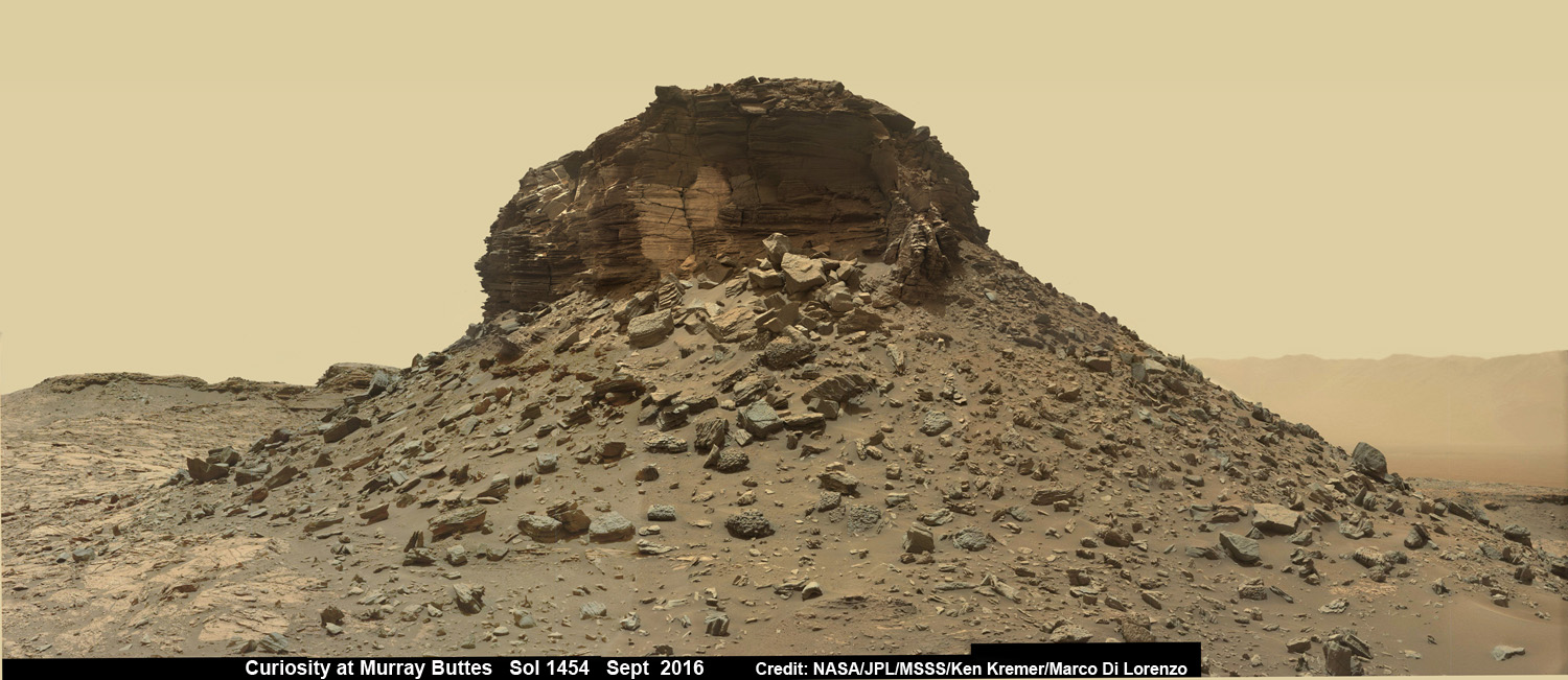
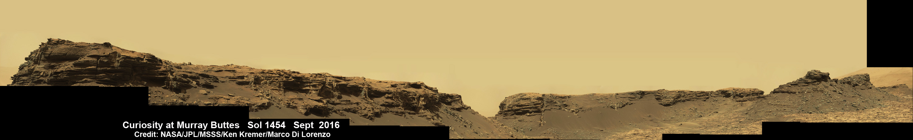
Dramatic wide angle mosaic view of butte with sandstone layers showing cross-bedding in the Murray Buttes region on lower Mount Sharp with distant view to rim of Gale crater, taken by Curiosity rover’s Mastcam high resolution cameras. This photo mosaic was assembled from Mastcam color camera raw images taken on Sol 1454, Sept. 8, 2016 and stitched by Ken Kremer and Marco Di Lorenzo, with added artificial sky. Featured at APOD on 5 Oct 2016. Credit: NASA/JPL/MSSS/Ken Kremer/kenkremer.com/Marco Di Lorenzo
Dramatic wide angle mosaic view of butte with sandstone layers showing cross-bedding in the Murray Buttes region on lower Mount Sharp with distant view to rim of Gale crater, taken by Curiosity rover’s Mastcam high resolution cameras. This photo mosaic was assembled from Mastcam color camera raw images taken on Sol 1454, Sept. 8, 2016 and stitched by Ken Kremer and Marco Di Lorenzo, with added artificial sky. Credit: NASA/JPL/MSSS/Ken Kremer/kenkremer.com/Marco Di Lorenzo
Our beyond magnificent Curiosity rover has just finished her latest Red Planet drilling campaign – at the rock target called “Quela” – into the simply unfathomable alien landscapes she is currently exploring at the “Murray Buttes” region of lower Mount Sharp. And it’s all in a Sols (or Martian Day’s) work for our intrepid Curiosity!
“These images are literally out of this world.. I don’t think I have seen anything like them on Earth!” Jim Green, Planetary Sciences Director at NASA Headquarters, Washington, D.C., explained to Universe Today.
The “Murray Buttes” region is just chock full of the most stunning panoramic vistas that NASA’s Curiosity Mars Science Laboratory rover has come upon to date. Observe and enjoy them in our exclusive new photo mosaics above and below.
“We always try to find some sort of Earth analog but these make exploring another world all worth it!” Green gushed in glee.
They fill the latest incredible chapter in her thus far four year long quest to trek many miles (km) from the Bradbury landing site across the floor of Gale Crater to reach the base region of humongous Mount Sharp.
And these adventures are just a prelude to the even more glorious vistas she’ll investigate from now on – as she climbs higher and higher on an expedition to thoroughly examine the mountains sedimentary layers and unravel billions and billions of years of Mars geologic and climatic history.
Drilling holes into Mars during the Red Planet trek and carefully analyzing the pulverized samples with the rovers pair of miniaturized chemistry laboratories (SAM and CheMin) is the route to the answer of how and why Mars changed from a warmer and wetter planet in the ancient past to the cold, dry and desolate world we see today.
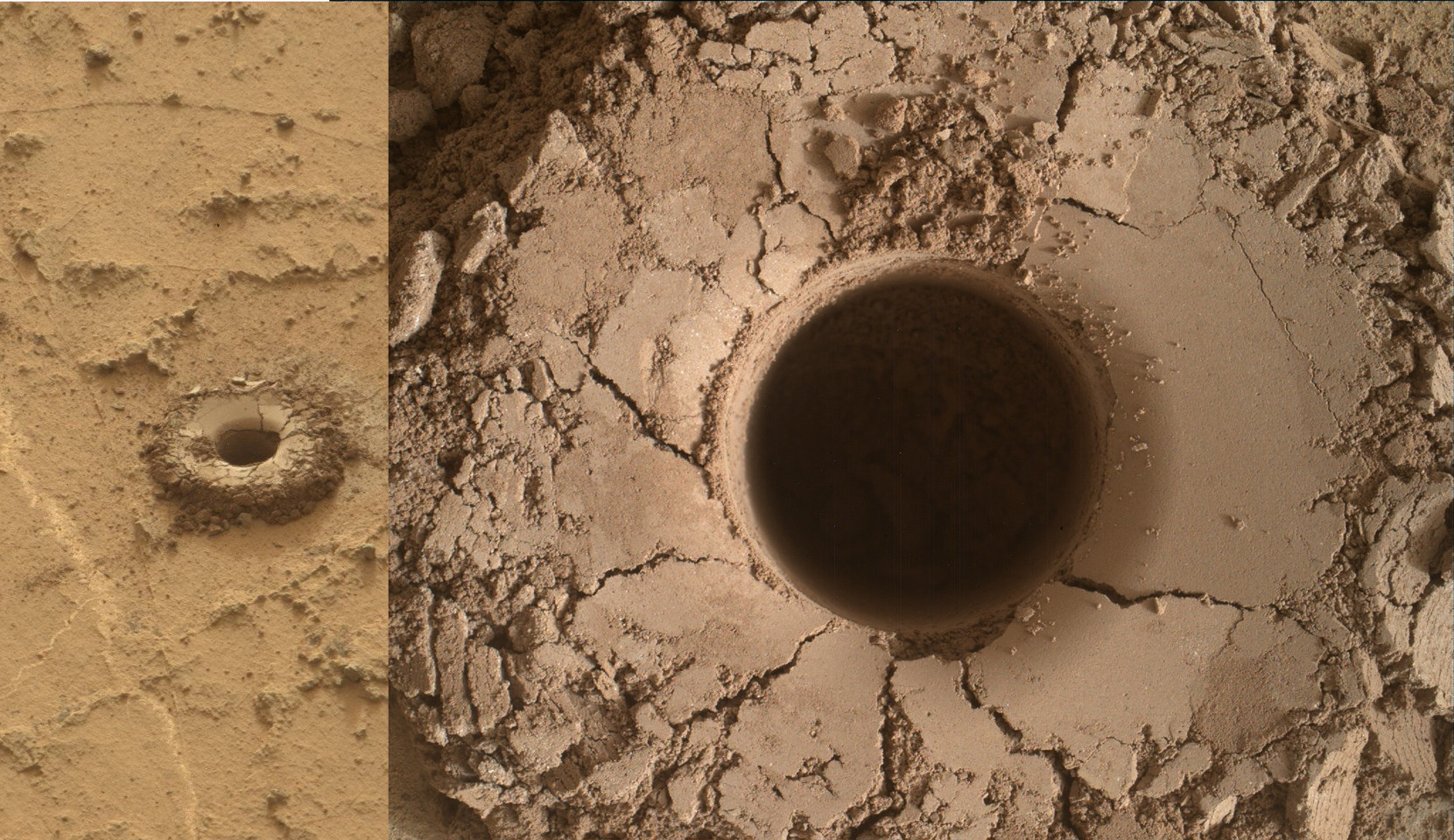
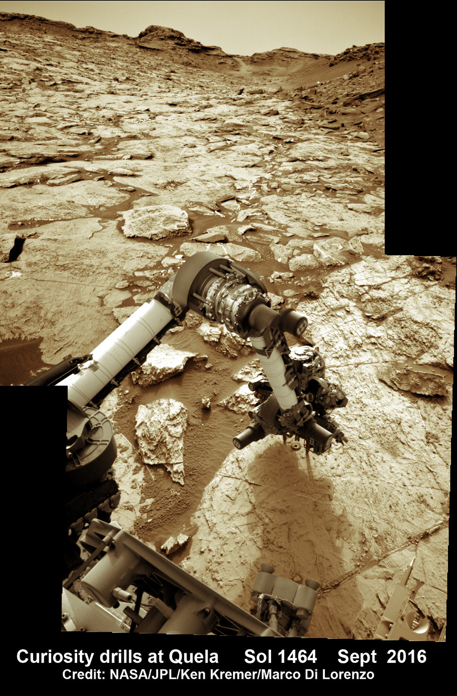
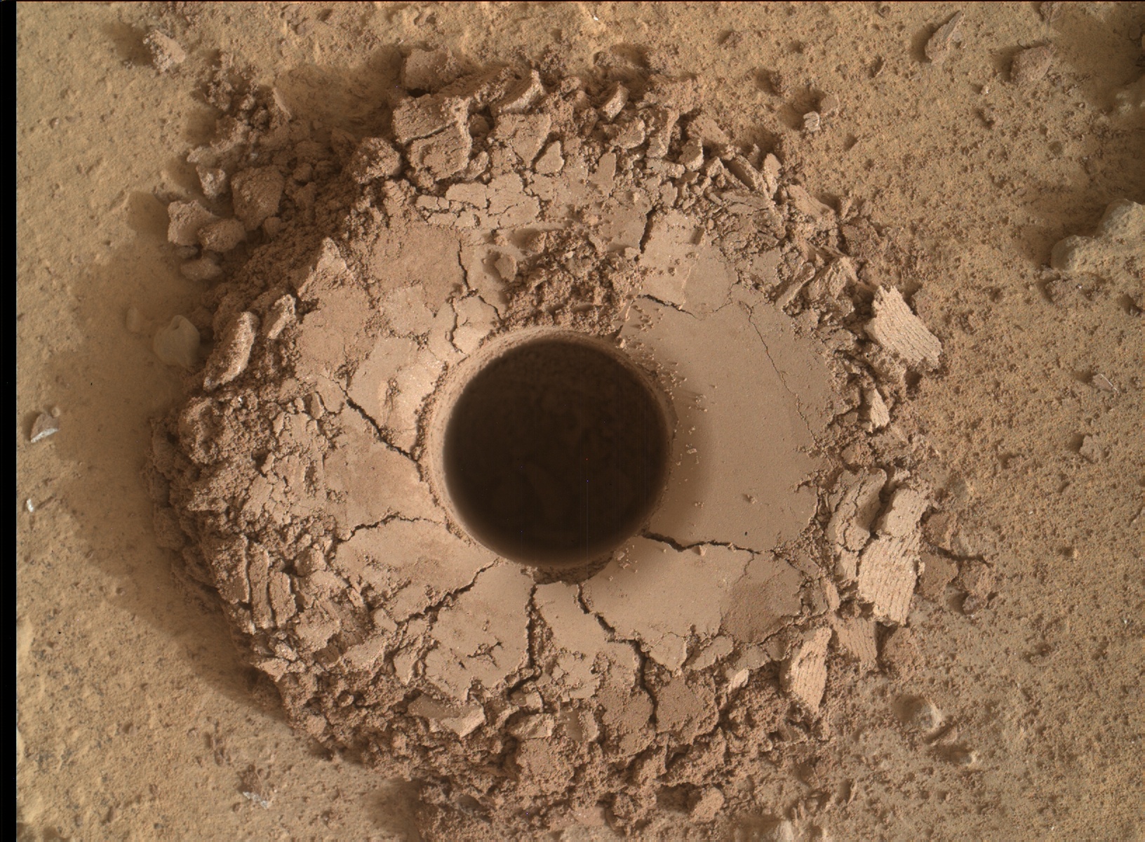
The rock target named “Quela” is located at the base of one of the buttes dubbed “Murray Butte number 12,” according to the latest mission update from Prof. John Bridges, a Curiosity rover science team member from the University of Leicester, England.
It took two tries to get the drilling done due to a technical issue, but all went well in the end and it was well worth the effort at a place never before explored by an emissary from Earth.
“The drill (successful at second attempt) is at Quela.”
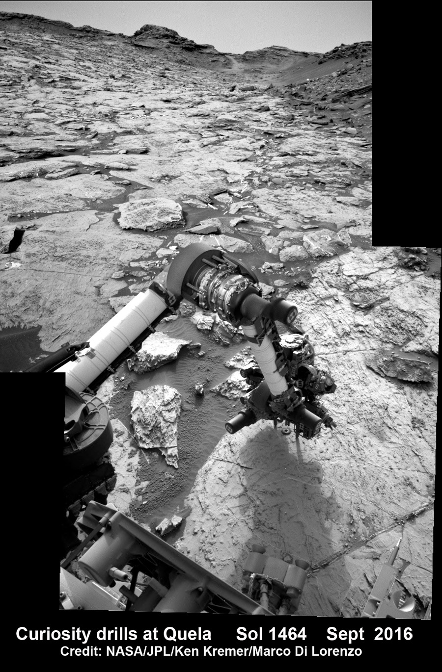
The full depth drilling was completed on Sol 1464, Sept. 18, 2016 using the percussion drill at the terminus of the outstretched 7-foot-long (2-meter-long) robotic arm – as confirmed by imaging and further illustrated in our navcam camera photo mosaic.
And that immediately provided valuable insight into climate change on Mars.
“You can see how red and oxidised the tailings are, suggesting changing environmental conditions as we progress through the Mt. Sharp foothills,” Bridges explained in the mission update.
Curiosity bore holes measure approximately 0.63 inch (1.6 centimeters) in diameter and 2.6 inches (6.5 centimeters) deep.
Quela drill hole bored by Curiosity rover on Sol 1464, Sept. 18, 2016 as seen in this collage of Mastcam and MAHLI raw color images taken on Sol 1465. Image Credit: NASA/JPL/MSSS. Collage: Marco Di Lorenzo/Ken Kremer
To give you the context of the Murray Buttes region and the drilling at Quela, the image processing team of Ken Kremer and Marco Di Lorenzo has begun stitching together wide angle mosaic landscape views and up close views of the drilling using raw images from the variety of cameras at Curiosity’s disposal.
The next steps after boring into Quela were to “sieve the new sample, dump the unsieved fraction, and drop some of the sieved sample into CheMin,” says Ken Herkenhoff, Research Geologist at the USGS Astrogeology Science Center and an MSL science team member, in a mission update.
“But first, ChemCam will acquire passive spectra of the Quela drill tailings and use its laser to measure the chemistry of the wall of the new drill hole and of bedrock targets “Camaxilo” and “Okakarara.” Right Mastcam images of these targets are also planned.”
“After sunset, MAHLI will use its LEDs to take images of the drill hole from various angles and of the CheMin inlet to confirm that the sample was successfully delivered. Finally, the APXS will be placed over the drill tailings for an overnight integration.”
The rover had approached the butte from the south side several sols earlier to get in place, plan for the drilling, take imagery to document stratigraphy and make compositional observations with the ChemCam laser instrument.
Curiosity drills into Quela rock target in the Murray Buttes region on Sol 1464, Sept. 18, 2016, in this navcam camera mosaic, stitched from raw images and colorized. Credit: NASA/JPL/Ken Kremer/kenkremer.com/Marco Di Lorenzo
“These are the landforms that dominate the landscape at this point in the traverse – The Murray Buttes,” says Bridges.
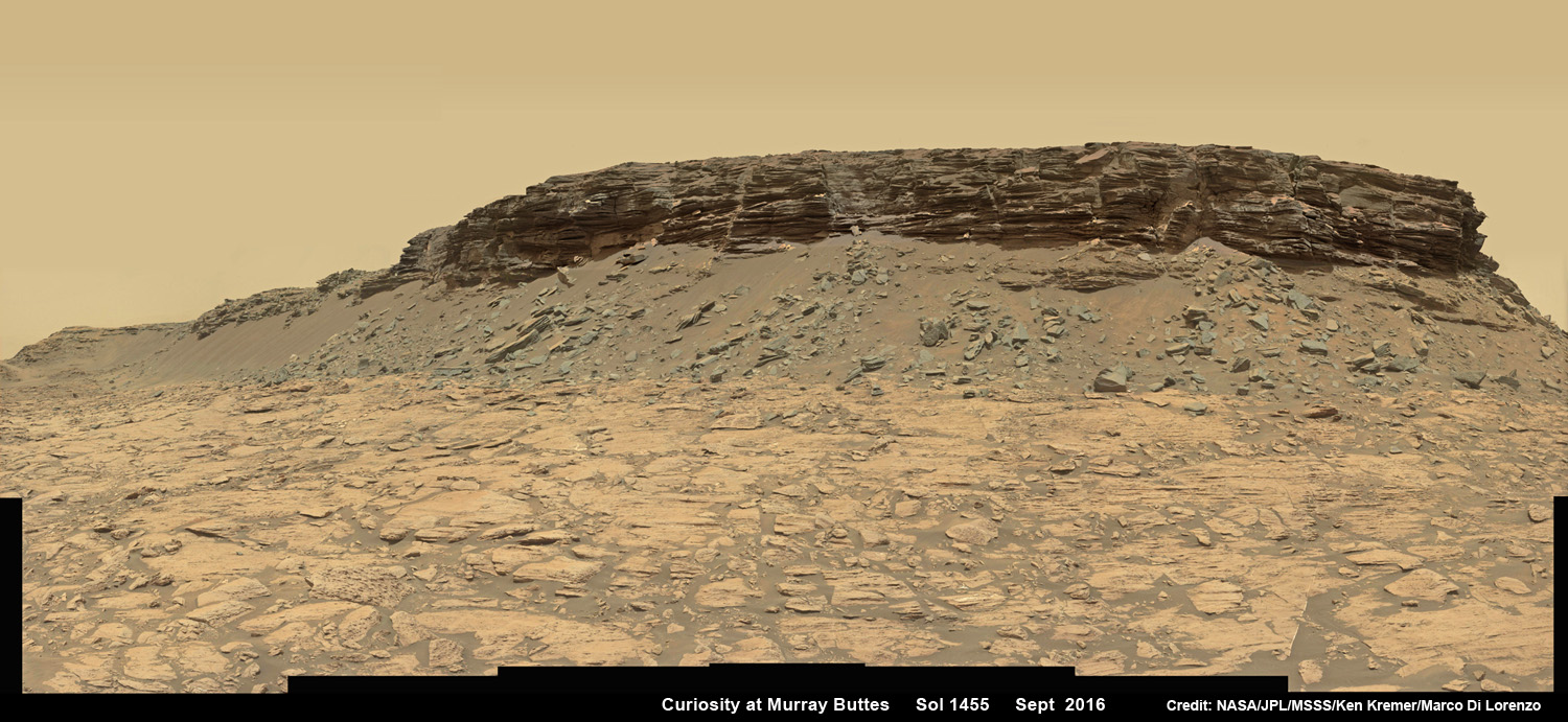
Wide angle mosaic view shows spectacular buttes and layered sandstone in the Murray Buttes region on lower Mount Sharp from the Mastcam cameras on NASA’s Curiosity Mars rover. This photo mosaic was assembled from Mastcam color camera raw images taken on Sol 1455, Sept. 9, 2016 and stitched by Marco Di Lorenzo and Ken Kremer, with added artificial sky. Credit: NASA/JPL/MSSS/Ken Kremer/kenkremer.com/Marco Di Lorenzo
What are the Murray Buttes?
“These are formed by a cap of hard aeolian rock that has been partially eroded back, overlying the Murray mudstone.”
The imagery of the Murray Buttes and mesas show them to be eroded remnants of ancient sandstone that originated when winds deposited sand after lower Mount Sharp had formed.
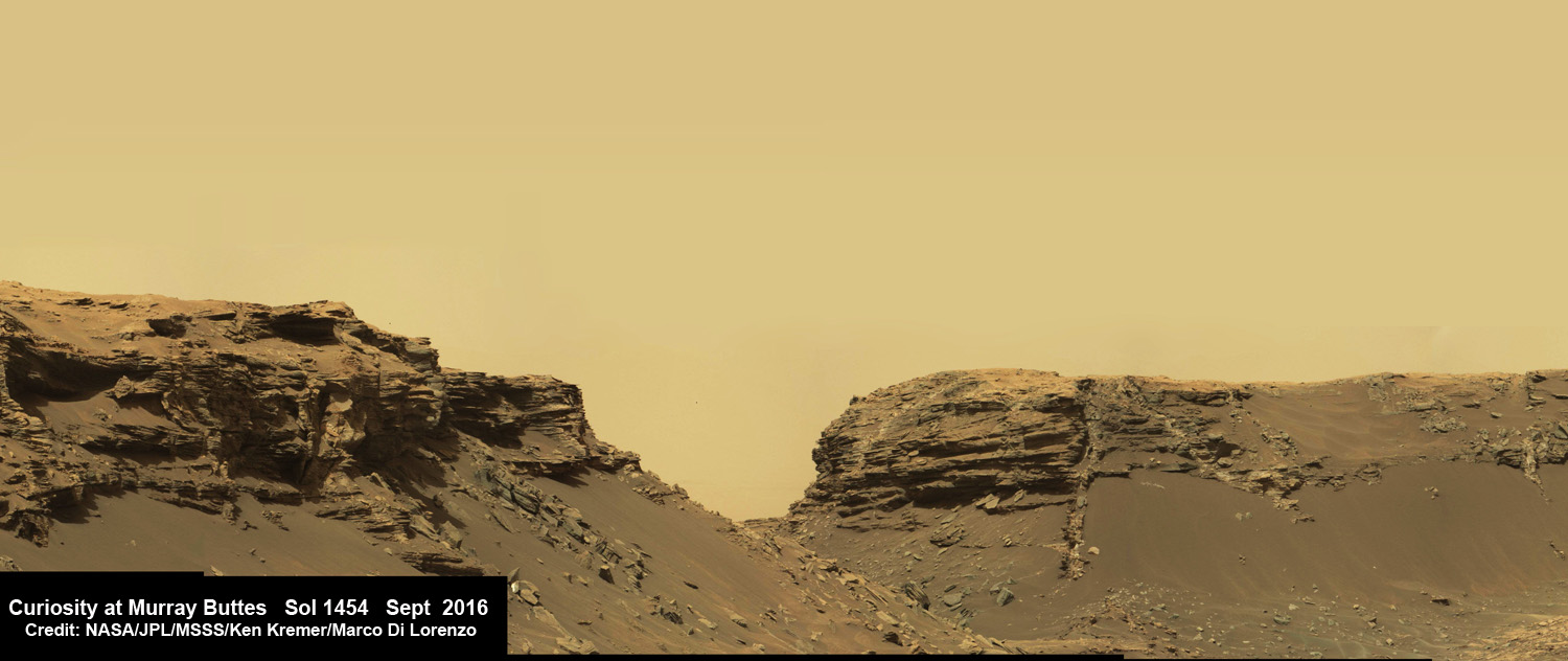
Scanning around the Murray Buttes mosaics one sees finely layered rocks, sloping hillsides, the distant rim of Gale Crater barely visible through the dusty haze, dramatic hillside outcrops with sandstone layers exhibiting cross-bedding.
The presence of “cross-bedding” indicates that the sandstone was deposited by wind as migrating sand dunes, says the team.
Spectacular wide angle mosaic view showing sloping buttes and layered outcrops within the Murray Buttes region on lower Mount Sharp from the Mast Camera (Mastcam) on NASA’s Curiosity Mars rover. This photo mosaic is stitched from Mastcam camera raw images taken on Sol 1454, Sept. 9, 2016 with added artificial sky. Credit: NASA/JPL/MSSS/Ken Kremer/kenkremer.com/Marco Di Lorenzo
Curiosity spent some six weeks or so traversing and exploring the Murray Buttes.
So after collecting all that great drilling data at Quela, the team is ready for even more spectacular new adventures!
“While the Murray Buttes were spectacular and interesting, it’s good to be back on the road again, as there is much more of Mt. Sharp to explore!” concludes Herkenhoff.
And the team is already commanding Curiosity to drive ahead in hot pursuit of the next drill target!
Dramatic hillside view showing sloping buttes and layered outcrops within of the Murray Buttes region on lower Mount Sharp from the Mast Camera (Mastcam) on NASA’s Curiosity Mars rover. This photo mosaic is stitched and cropped from Mastcam camera raw images taken on Sol 1454, Sept. 8, 2016, with added artificial sky. Credit: NASA/JPL/MSSS/Ken Kremer/kenkremer.com/Marco Di Lorenzo
Ascending and diligently exploring the sedimentary lower layers of Mount Sharp, which towers 3.4 miles (5.5 kilometers) into the Martian sky, is the primary destination and goal of the rovers long term scientific expedition on the Red Planet.
Curiosity rover panorama of Mount Sharp captured on June 6, 2014 (Sol 651) during traverse inside Gale Crater. Note rover wheel tracks at left. She will eventually ascend the mountain at the ‘Murray Buttes’ at right later this year. Assembled from Mastcam color camera raw images and stitched by Marco Di Lorenzo and Ken Kremer. Credit: NASA/JPL/MSSS/Marco Di Lorenzo/Ken Kremer-kenkremer.com
Three years ago, the team informally named the Murray Buttes site to honor Caltech planetary scientist Bruce Murray (1931-2013), a former director of NASA’s Jet Propulsion Laboratory, Pasadena, California. JPL manages the Curiosity mission for NASA.
As of today, Sol 1470, September 24, 2016, Curiosity has driven over 7.9 miles (12.7 kilometers) since its August 2012 landing inside Gale Crater, and taken over 355,000 amazing images.
Stay tuned here for Ken’s continuing Earth and planetary science and human spaceflight news.
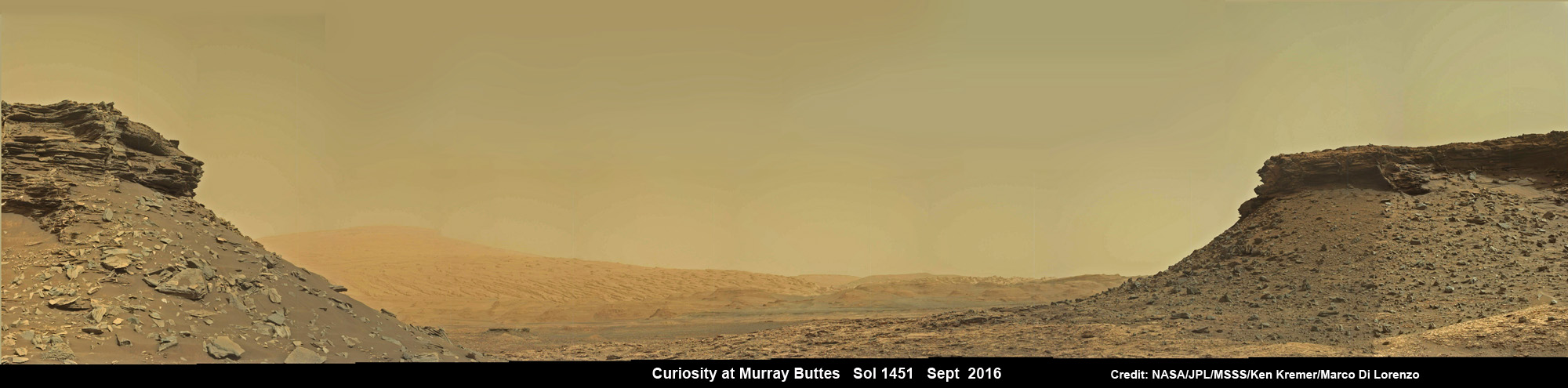
Wide angle mosaic shows lower region of Mount Sharp at center in between spectacular sloping hillsides and layered rock outcrops of the Murray Buttes region in Gale Crater as imaged by the Mast Camera (Mastcam) on NASA’s Curiosity Mars rover. This photo mosaic is stitched from Mastcam camera raw images taken on Sol 1451, Sept. 5, 2016 with added artificial sky. Credit: NASA/JPL/MSSS/Ken Kremer/kenkremer.com/Marco Di LorenzoQuela drill hole bored by Curiosity rover on Sol 1464, Sept. 18, 2016 as seen in this MAHLI arm camera raw color image taken the same Sol. Credit: NASA/JPL/MSSSCuriosity drills into Quela rock target on Sol 1464, Sept. 18, 2016 in this navcam camera mosaic. Credit: NASA/JPL/Ken Kremer/kenkremer.com/Marco Di Lorenzo