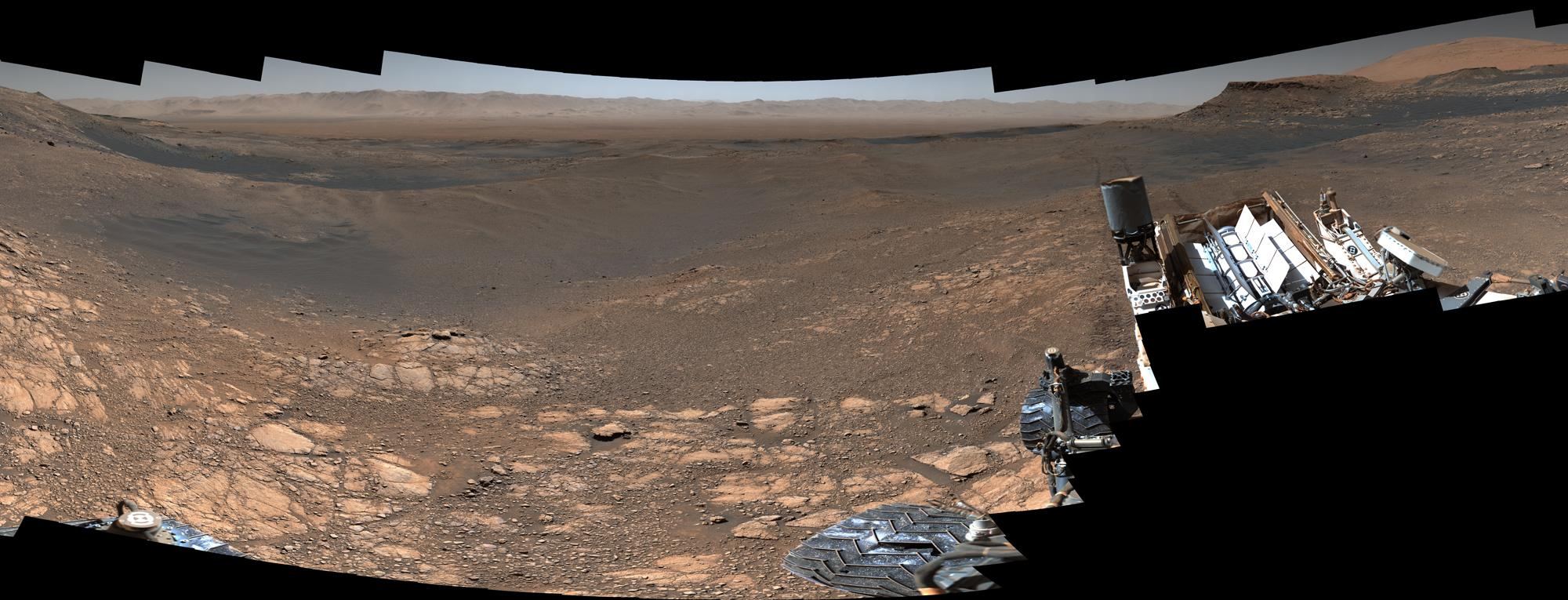
The Curiosity rover on Mars has captured the most detailed panoramic image ever taken of the Red Planet’s surface. The image is made from over 1,000 images, containing 1.8 billion pixels of the Martian landscape, with 2.43 GB of high-resolution planetary goodness.
“This is the first time during the mission we’ve dedicated our operations to a stereo 360-degree panorama,” said Curiosity Project Scientist Ashwin Vasavada.
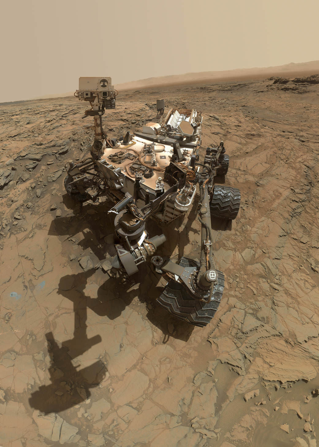
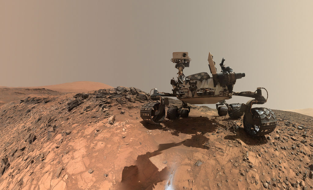
This self-portrait of NASA's Curiosity Mars rover shows the vehicle at the "Big Sky" site. Credit: NASA/JPL-Caltech/MSSS
Following is the final excerpt from my new book, “Incredible Stories From Space: A Behind-the-Scenes Look at the Missions Changing Our View of the Cosmos.” The book is an inside look at several current NASA robotic missions, and this excerpt is part 3 of 3 posted here on Universe Today, of Chapter 2, “Roving Mars with Curiosity.” You can read Part 1 here, and Part 2 here. The book is available in print or e-book (Kindle or Nook) Amazon and Barnes & Noble.
How to Drive a Mars Rover
How does Curiosity know where and how to drive across Mars’ surface? You might envision engineers at JPL using joysticks, similar to those used for remote control toys or video games. But unlike RC driving or gaming, the Mars rover drivers don’t have immediate visual inputs or a video screen to see where the rover is going. And just like at the landing, there is always a time delay of when a command is sent to the rover and when it is received on Mars.
“It’s not driving in a real-time interactive sense because of the time lag,” explained John Michael Morookian, who leads the team of rover drivers.
The actual job title of Morookian and his team are ‘Rover Planners,’ which precisely describes what they do. Instead of ‘driving’ the rovers per se; they plan out the route in advance, program specialized software, and upload the instructions to Curiosity.
“We use images taken by the rover of its surroundings,” said Morookian. “We have a set of stereo images from four black-and-white Navigation Cameras, along with images from the Hazcams (hazard avoidance cameras), supported by high-resolution color images from the MastCam that give us details about the nature of the terrain ahead and clues about types of rocks and minerals at the site. This helps identify structures that look interesting to the scientists.”
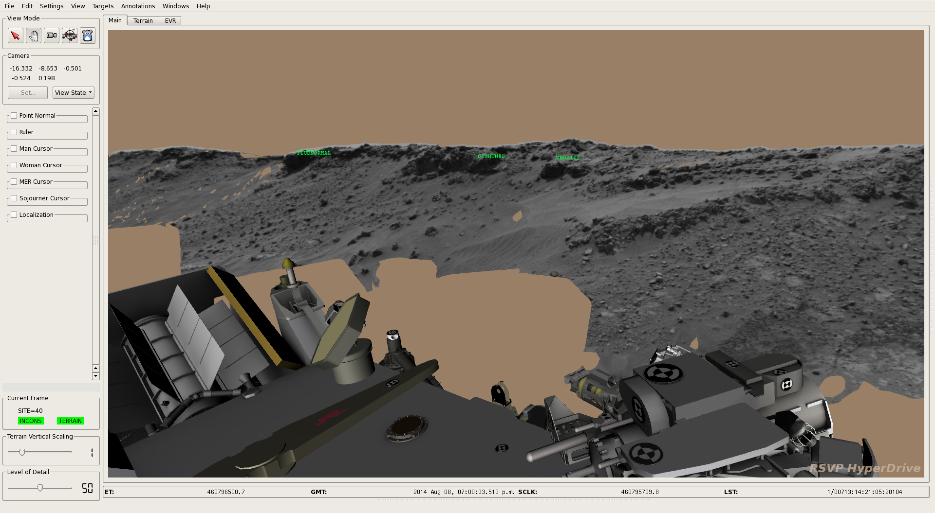
Using all available data, they can create a three-dimensional visualization of the terrain with specialized software called the Rover Sequencing and Visualization Program (RSVP).
“This is basically a Mars simulator and we put a simulated Curiosity in a panorama of the scene to visualize how the rover could traverse on its path,” Morookian explained. “We can also put on stereo glasses, which allow our eyes to see the scene in three dimensions as if we were there with the rover.
In virtual reality, the rover drivers can manipulate the scene and the rover to test every possibility of which routes are the best and what areas to avoid. There, they can make all the mistakes (get stuck in a dune, tip the rover, crash into a big rock, drive off a precipice) and perfect the driving sequence while the real rover remains safe on Mars.
“The scientists also review the images for features that are interesting and consult with the Rover Planners to help define a path. Then we compose the detailed commands that are necessary to get Curiosity from Point A to Point B along that path,” Morookian said. “”We can also incorporate the commands needed to give the rover direction to make contact with the site using its robotic arm.”
When Curiosity’s Navigation Cameras (Navcams) take black-and-white images and send them back to Earth each day, rover planners combine them with other rover data to create 3D terrain models. By adding a computerized 3D rover model to the terrain model, rover planners can understand better the rover’s position, as well as distances to, and scale of, features in the landscape. Credit: NASA/JPL-Caltech.
So, every night the rover is commanded to shut down for eight hours to recharge its batteries with the nuclear generator. But first Curiosity sends data to Earth, including pictures of the terrain and any science information. On Earth, the Rover Planners take that data, do their planning work, complete the software programing and beam the information back to Mars. Then Curiosity wakes up, downloads the instructions and sets to work. And the cycle repeats.
Curiosity also has an AutoNav feature which allows the rover to traverse areas the team hasn’t seen yet in images. So, it could go over the hill and down the other side to uncharted territory, with the AutoNav sensing potential hazards.
“We don’t use it too often because it is computationally expensive, meaning it takes much longer for the rover to operate in that mode,” Morookian said. “We often find it’s a better trade to just come in the next day, look at the images and drive as far as we can see.”
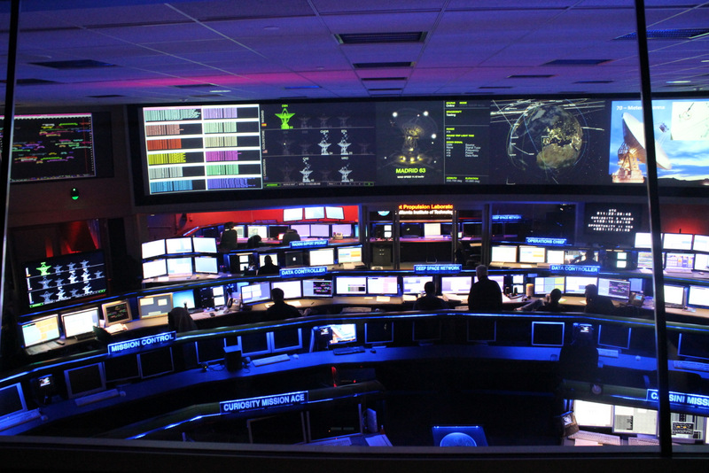
A view of the Space Flight Operations Facility at the Jet Propulsion Laboratory, where all the data going both to and from all planetary missions is sent and received via the Deep Space Network. Credit: Nancy Atkinson.
As Morookian showed me the various rooms used by rover planning teams at JPL, he explained how they need to operate over a number of different timescales.
“We not only have the daily route planning,” he said, “but also do long-range strategic planning using orbital imagery from the HiRISE camera on the Mars Reconnaissance Orbiter and choose paths based on features seen from orbit. Our team works strategically, looking many months out to define the best paths.”
Another process called Supra-Tactical looks out to just the next week. This involves science planners managing and refining the types of activities the rover will be doing in the short term. Also, since no one on the team lives on Mars Time anymore, on Fridays the Rover Planners work out the plans for several days.
“Since we don’t work weekends, Friday plans contain multiple sols of activities,” Morookian said. “Two parallel teams decide which days the rover will drive and which days it will do other activities, such as work with the robotic arm or other instruments.”
The data that comes down from the rover over the weekend is monitored, however, and if there is a problem, a team is called in to do a more detailed assessment. Morookian indicated they’ve had to engage the emergency weekend team several times, but so far there have been no serious problems. “It does keep us on our toes, however,” he said.
The rover features a number of reactive safety checks on the amount of overall tilt of the rover deck and the articulation of the suspension system of the wheels, so if the rover is going over an object that is too large, it will automatically stop.
Curiosity wasn’t built for speed. It was designed to travel up to 660 feet (200 meters) in a day, but it rarely travels that far in a Sol. By early 2016 the rover had driven a total of about 7.5 miles (12 km) across Mars’ surface.
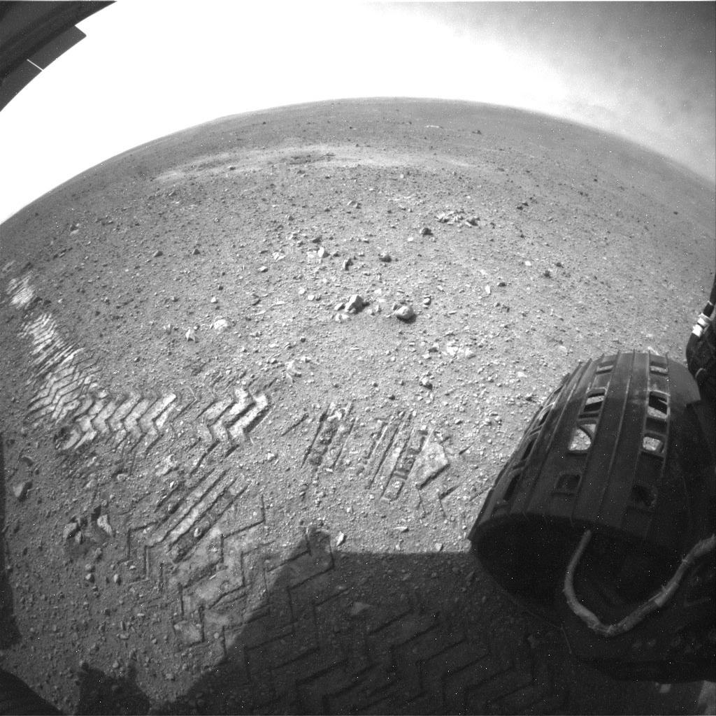
This image shows a close-up of track marks left by the Curiosity rover. Holes in the rover’s wheels, seen here in this view, leave imprints in the tracks that can be used to help the rover drive more accurately. The imprint is Morse code for ‘JPL,’ and aids in tracking how far the rover has traveled. Credit: NASA/JPL-Caltech.
There are several ways to determine how far Curiosity has traveled, but the most accurate measurement is called ‘Visual Odometry.’ Curiosity has specialized holes in its wheels in the shape of Morse code letters, spelling out ‘JPL’ – a nod to the home of the rover’s science and engineering teams – across the Martian soil.
“Visual odometry works by comparing the most recent pair of stereo images collected roughly every meter over the drive,” said Morookian. “Individual features in the scene are matched and tracked to provide a measure of how the camera (and thus the rover) has translated and rotated in 3 dimensional space between the two images and it tells us in a very real sense how far Curiosity has gone.”
Careful inspection of the rover tracks can reveal the type of traction the wheels have and if they have slipped, for instance due to high slopes or sandy ground.
Unfortunately, Curiosity now has new holes in its wheels that aren’t supposed to be there.
Rover Problems
Morookian and Project Scientist Ashwin Vasavada both expressed relief and satisfaction that overall — this far into the mission — Curiosity is a fairly healthy rover. The entire science payload is currently operating at nearly full capability. But the engineering team keeps an eye on a few issues.
“Around sol 400, we realized the wheels were wearing faster than we expected,” Vasavada said.
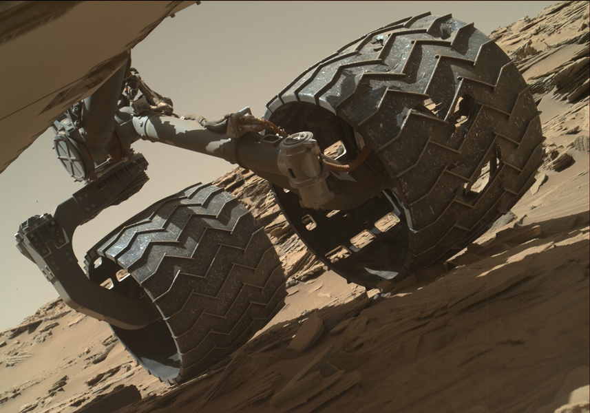
The team operating the Curiosity Mars rover uses the Mars Hand Lens Imager (MAHLI) camera on the rover’s arm to check the condition of the wheels at routine intervals. This image of Curiosity’s left-middle and left-rear wheels is part of an inspection set taken on April 18, 2016, during the 1,315th sol of the rover’s work on Mars. Credit: NASA/JPL-Caltech/MSSS.
And the wear didn’t consist of just little holes; the team started to see punctures and nasty tears. Engineers realized the holes were being created by the hard, jagged rocks the rover was driving over during that time.
“We weren’t fully expecting the kind of ‘pointy’ rocks that were doing damage,” Vasavada said. “We also did some testing and saw how one wheel could push another wheel into a rock, making the damage worse. We now drive more carefully and don’t drive as long as we have in the past. We’ve been able to level off the damage to a more acceptable rate.”
Early in the mission, Curiosity’s computer went into ‘safe mode’ several times, as Curiosity’s software recognized a problem, and the response was to disallow further activity and phone home.
Specialized fault protection software runs throughout the modules and instruments, and when a problem occurs, the rover stops and sends data called ‘event records’ to Earth. The records include various categories of urgency, and in early 2015, the rover sent a message that essentially said, “This is very, very bad.” The drill on the rover’s arm had experienced a fluctuation in an electrical current – like a short circuit.
“Curiosity’s software has the ability to detect shorts, like the ground fault circuit interrupter you have in your bathroom,” Morookian explained, “except this one tells you ‘this is very, very bad’ instead of just giving you a yellow light.”
Since the team can’t go to Mars and repair a problem, everything is fixed either by sending software updates to the rover or by changing operational procedures.
Curiosity’s drill in the turret of tools at the end of the robotic arm positioned in contact with the rock surface for the first drilling of the mission on the 170th sol of Curiosity’s work on Mars (Jan. 27, 2013) in Yellowknife Bay. The picture was taken by the front Hazard-Avoidance Camera (Hazcam). Image credit: NASA/JPL-Caltech.
“We are just more careful now with how we use the drill,” Vasavada said, “and don’t drill with full force at the beginning, but slowly ramp up. It’s sort of like how we drive now, more gingerly but it still gets the job done. It hasn’t been a huge impact as of yet.”
A lighter touch on the drill also was necessary for the softer mudstones and sandstones the rover encountered. Morookian said there was concern the layered rocks might not hold up under the assault of the standard drilling protocol, and so they adjusted the technique to use the lowest ‘settings’ that still allows the drill to make sufficient progress into the rock.
But opportunities to use the drill are increasing as Curiosity begins its traverse up the mountain. The rover is traveling through what Vasavada calls a “target rich, very interesting area,” as the science team works to tie together the geological context of everything they are seeing in the images.
Finding Balance on Mars
While the diversion at Yellowknife Bay allowed the team to make some major discoveries, they felt pressure to get to Mt. Sharp, so “drove like hell for a year,” Vasavada said.
Now on the mountain, there is still the pressure to make the most of the mission, with the goal of making it through at least four different rock units – or layers — on Mt. Sharp. Each layer could be like a chapter in the book of Mars’ history.
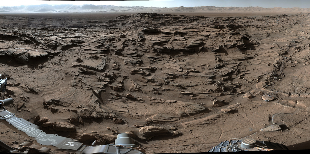
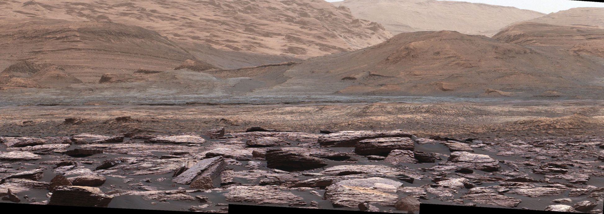
A portion of a panorama from Curiosity’s Mastcam shows the rugged surface of ‘Naukluft Plateau’ plus part of the rim of Gale Crater, taken on April 4, 2016 or Sol 1301. Credit: NASA/JPL-Caltech/MSSS
“Exploring Mt. Sharp is fascinating,” Vasavada said, “and we’re trying to maintain a mix between really great discoveries, which – you hate to say — slows us down, and getting higher on the mountain. Looking closely at a rock in front of you means you’ll never be able to go over and look at that other interesting rock over there.”
Vasavada and Morookian both said it’s a challenge to preserve that balance every day — to find what’s called the ‘knee in the curve’ or ‘sweet spot’ of the perfect optimization between driving and stopping for science.
Then there’s the balance between stopping to do a full observation with all the instruments and doing ‘flyby science’ where less intense observations are made.
“We take the observations we can, and generate all the hypotheses we can in real time,” Vasavada said. “Even if we’re left with 100 open questions, we know we can answer the questions later as long as we know we’ve taken enough data.”
Curiosity’s primary target is not the summit, but instead a region about 1,330 feet (400 meters) up where geologists expect to find the boundary between rocks that saw a lot of water in their history, and those that didn’t. That boundary will provide insight into Mars’ transition from a wet planet to dry, filling in a key gap in the understanding of the planet’s history.
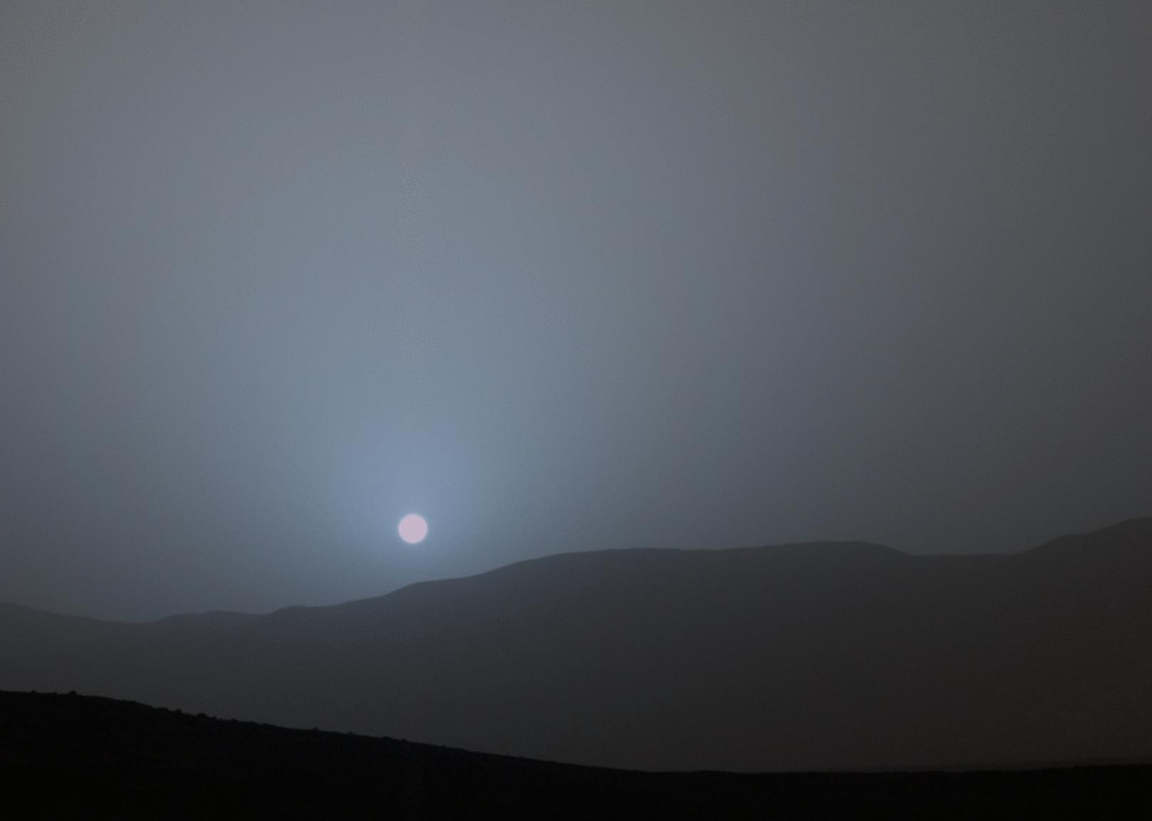
he Curiosity rover recorded this view of the Sun setting at the close of the mission’s 956th sol (April 15, 2015), from the rover’s location in Gale Crater. This was the first sunset observed in color by Curiosity. The image comes from the left-eye camera of the rover’s Mast Camera (Mastcam). Credit: NASA/JPL-Caltech/MSSS/Texas A&M University.
No one really knows how long Curiosity will last, or if it will surprise everyone like its predecessors Spirit and Opportunity. Having made it past the ‘prime mission’ of one year on Mars (two Earth years), and now in the extended mission, the one big variable is the RTG power source. While the available power will start to steadily decrease, both Vasavada and Morookian don’t expect that to be in an issue for at least four more Earth years, and with the right “nurturing,” power could last for a dozen years or more.
But they also know there’s no way to predict how long Curiosity will go, or what unexpected event might end the mission.
The Beast
Does Curiosity have a personality like the previous Mars rovers?
“Actually no, we don’t seem to anthropomorphize this rover like people did with Spirit and Opportunity,” Vasavada said. “We haven’t bonded emotionally with it. Sociologists have actually been studying this.” He shook his head with an amused smile.
Vasavada indicated it might have something to do with Curiosity’s size.
“I think of it as a giant beast,” he said straight-faced. “But not in a mean way at all.”
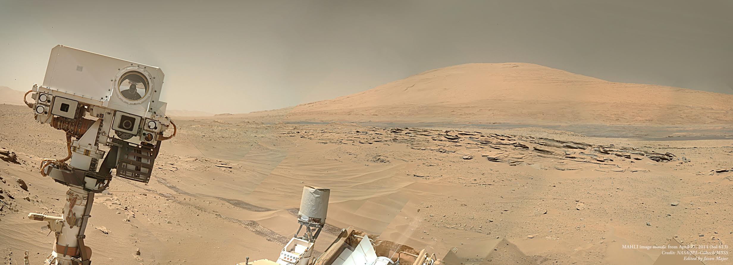
Curiosity appears to be photobombing Mount Sharp in this selfie image, a mosaic created from several MAHLI images. Credit: NASA/JPL-Caltech/MSSS/Edited by Jason Major.
What has come to come to characterize this mission, Vasavada said, is the complexity of it, in every dimension: the human component of getting 500 people to work and cooperate together while optimizing everyone’s talents; keeping the rover safe and healthy; and keeping ten instruments going every day, which are sometimes doing completely unrelated science tasks.
“Every day is our own little ‘seven minutes of terror,’ where so many things have to go right every single day,” Vasavada said. “There are a million potential issues and interactions, and you have to constantly be thinking about all the ways things can go wrong, because there are a million ways you can mess up. It’s an intricate dance, but fortunately we have a great team.”
Then he added with a smile, “This mission is exciting though, even if it’s a beast.”
“Incredible Stories From Space: A Behind-the-Scenes Look at the Missions Changing Our View of the Cosmos” is published by Page Street Publishing, a subsidiary of Macmillan.
Author Nancy Atkinson at JPL with a model of the Curiosity Rover.
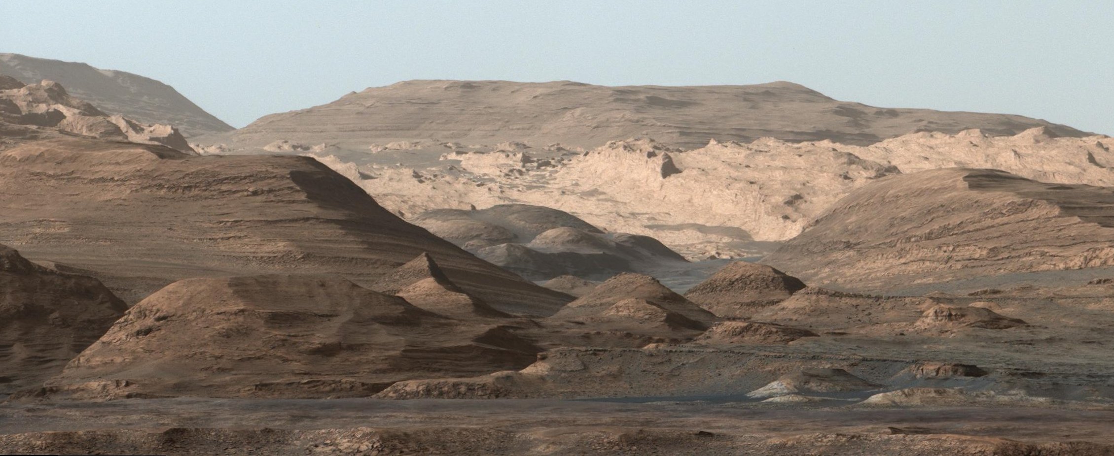
Curiosity's view of Mount Sharp, taken with the MastCam on Sept. 9th, 2015. Credit: NASA/JPL-Caltech/MSSS
Following is Part 2 of an excerpt from my new book, “Incredible Stories From Space: A Behind-the-Scenes Look at the Missions Changing Our View of the Cosmos.” The book is an inside look at several current NASA robotic missions, and this excerpt is part 2 of 3 which will be posted here on Universe Today, of Chapter 2, “Roving Mars with Curiosity.” You can read Part 1 here. The book is available in print or e-book (Kindle or Nook) Amazon and Barnes & Noble.
Living on Mars Time
The landing occurred at 10:30 pm in California. The MSL team had little time to celebrate, transitioning immediately to mission operations and planning the rover’s first day of activity. The team’s first planning meeting started at 1 o’clock in the morning, ending about 8 a.m. They had been up all night, putting in a nearly 40-hour day.
This was a rough beginning of the mission for the scientists and engineers who needed to live on ‘Mars Time.’
A day on Mars day is 40 minutes longer than Earth’s day, and for the first 90 Mars days – called sols — of the mission, the entire team worked in shifts around the clock to constantly monitor the newly landed rover. To operate on the same daily schedule as the rover meant a perpetually shifting sleep/wake cycle where the MSL team would alter their schedules 40 minutes every day to stay in sync with the day and night schedules on Mars. If team members came into work at 9:00 a.m., the next day, they’d come in at 9:40 a.m., and the next day at 10:20 a.m., and so on.
Those who have lived through Mars Time say their bodies continually feel jet-lagged. Some people slept at JPL so as not to disrupt their family’s schedule, some wore two watches so they would know what time it was on two planets.
About 350 scientists from around the world were involved with MSL and many of them stayed at JPL for the first 90 sols of the mission, living on Mars Time.
But it took less than 60 Earth days for the team to announce Curiosity’s first big discovery.
Water, Water …
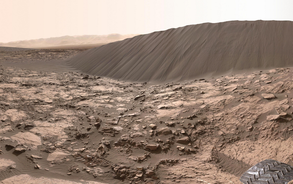
A 16-ft. (5 m) high sand dune on Mars called Namib Dune is part of the dark-sand ‘Bagnold Dunes’ field along the northwestern flank of Mount Sharp. Images taken from orbit indicate that dunes in the Bagnold field move as much as about 3 feet (1 m) per Earth year. This image is part of a 360 degree panorama taken by the Curiosity rover on Dec. 18, 2015 or the 1,197th Martian day, or sol, of the rover’s work on Mars. Credit: NASA/JPL-Caltech/MSSS.
Ashwin Vasavada grew up in California and has fond childhood memories of visiting state and national parks in the southwest United States with his family, playing among sand dunes and hiking in the mountains. He’s now able to do both on another planet, vicariously through Curiosity. The day I visited Vasavada at his office at JPL in early 2016, the rover was navigating through a field of giant sand dunes at the base of Mount Sharp, with some dunes towering 30 feet (9 meters) above the rover.
“It’s just fascinating to see dunes close up on another planet,” Vasavada said. “And the closer we get to the mountain, the more fantastic the geology gets. So much has gone on there, and we have so little understanding of it … as of yet.”
At the time we talked, Curiosity was approaching four Earth years on Mars. The rover is now studying those enticing sedimentary layers on Mt. Sharp in closer detail. But first, it needed to navigate through the “Bagnold Dunes” which form a barrier along the northwestern flank of the mountain. Here, Curiosity is doing what Vasavada calls “flyby science,” stopping briefly to sample and study the sand grains of the dunes while moving through the area as quickly as possible.
Now working as the lead Project Scientist for the mission, Vasavada plays an even larger role in coordinating the mission.
“It’s a constant balance of doing things quickly, carefully and efficiently, as well as using the instruments to their fullest,” he said.
Since the successful August 2012 landing, Curiosity has sent back tens of thousands of images from Mars – from expansive panoramas to extreme close-ups of rocks and sand grains, all of which are helping to tell the story of Mars’ past.
‘Selfies’ taken by the Curiosity rover are actually a mosaic created from numerous images taken with the Mars Hand Lens Imager (MAHLI), located on the end of the rover’s robotic arm. However, the arm is not shown in the selfies, because with the wrist motions and turret rotations used in pointing the camera for the component images, the arm was positioned out of the shot in the frames or portions of frames used in this mosaic. However, the shadow of the arm is visible on the ground. This low-angle selfie shows the vehicle at the site from which it reached down to drill into a rock target called “Buckskin” on lower Mount Sharp. Credit: NASA/JPL-Caltech/MSSS.
The images the public seems to love the most are the ‘selfies,’ the photos the rover takes of itself sitting on Mars. The selfies aren’t just a single image like the ones we take with our cell phones, but a mosaic created from dozens of separate images taken with the Mars Hand Lens Imager (MAHLI) camera at the end of the rover’s robotic arm. Other fan favorites are the pictures Curiosity takes of the magnificent Martian landscape, like a tourist documenting its journey.
Vasavada has a unique personal favorite.
“For me, the most meaningful picture from Curiosity really isn’t that great of an image,” he said, “but it was one of our first discoveries so it has an emotional tie to it.”
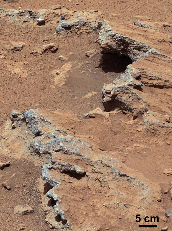
Within the first 50 sols, Curiosity took pictures of what geologists call conglomerates: a rock made of pebbles cemented together. But these were no ordinary pebbles — they were pebbles worn by flowing water. Serendipitously, the rover had found an ancient streambed where water once flowed vigorously. From the size of pebbles, the science team could interpret the water was moving about 3 feet (1 meter) per second, with a depth somewhere between a few inches to several feet. This geological feature on Mars is exposed bedrock made up of smaller fragments cemented together, or what geologists call a sedimentary conglomerate, and is evidence for an ancient, flowing stream. Some of embedded and loose gravel are round in shape, leading the Curiosity science team to conclude it were transported by a vigorous flow of water. Curiosity’s 100-millimeter Mastcam telephoto lens on its 39th sol of the mission (Sept. 14, 2012). Credit: NASA/JPL-Caltech/MSSS
“When you see this picture, and whether you are a gardener or geologist, you know what this means,” Vasasvada said excitedly. “At Home Depot, the rounded rock for landscaping are called river pebbles! It was mind-blowing to me to think that the rover was driving through a streambed. That picture really brought home there was actually water flowing here long ago, probably ankle to hip deep.”
Vasavada looked down. “It still gives me the shivers, just thinking about it,” he said, with his passion for exploration and discovery visibly evident.
From that early discovery, Curiosity continued to find more water-related evidence. The team took a calculated gamble and instead of driving straight towards Mt. Sharp, took a slight detour to the east to an area dubbed ‘Yellowknife Bay.’
“Yellowknife Bay was something we saw with the orbiters,” Vasavada explained, “and there appeared to be a debris fan fed by a river—evidence for flowing water in the ancient past.”
This map shows the route driven by NASA’s Curiosity Mars rover from the location where it landed in August 2012 to its location in September 2016 at “Murray Buttes,” and the path planned for reaching destinations at “Hematite Unit” and “Clay Unit” on lower Mount Sharp. Credits: NASA/JPL-Caltech/Univ. of Arizona
Here, Curiosity fulfilled ones of its main goals: determining whether Gale Crater ever was habitable for simple life forms. The answer was a resounding yes. The rover sampled two stone slabs with the drill, feeding half-baby-aspirin-sized portions to SAM, the onboard lab. SAM identified traces of elements like carbon, hydrogen, nitrogen, oxygen, and more —the basic building blocks of life. It also found sulfur compounds in different chemical forms, a possible energy source for microbes.
Data gathered by Curiosity’s other instruments constructed a portrait detailing how this site was once a muddy lakebed with mild – not acidic – water. Add in the essential elemental ingredients for life, and long ago, Yellowknife Bay would have been the perfect spot for living organisms to hang out. While this finding doesn’t necessarily mean there is past or present life on Mars, it shows the raw ingredients existed for life to get started there at one time, in a benign environment.
“Finding the habitable environment in Yellowknife Bay was wonderful because it really showed the capability our mission has to measure so many different things,” Vasavada said. “A wonderful picture came together of streams that flowed into a lake environment. This was exactly what we were sent there to find, but we didn’t think we’d find it that early in the mission.”
Still, this lakebed could have been created by a one-time event over just hundreds of years. The ‘jackpot’ would be to find evidence of long-term water and warmth.
That discovery took a little longer. But personally, it means more to Vasavada.
Mars’ climate was one of Vasavada’s early interests in his career and he spent years creating models, trying to understand Mars’ ancient history.
“I grew up with pictures of Mars from the Viking mission,” he said, “and thinking of it as a barren place with jagged volcanic rock and a bunch of sand. Then I had done all this theoretical work about Mars climate, that rivers and oceans perhaps once existed on Mars, but we had no real evidence.”
That’s why the discovery made by Curiosity in late 2015 is so exciting to Vasavada and his team.
“We didn’t just see the rounded pebbles and remnants of the muddy lake bottom at Yellowknife Bay, but all along the route,” Vasavada said. “We saw river pebbles first, then tilted sandstones where the river emptied into lakes. Then as we got to Mt. Sharp, we saw huge expanses of rock made of the silt that settled out from the lakes.”
The explanation that best fits the “morphology” in this region — that is, the configuration and evolution of rocks and land forms – is rivers formed deltas as they emptied into a lake. This likely occurred 3.8 to 3.3 billion years ago. And the rivers delivered sediment that slowly built up the lower layers of Mt. Sharp.
Curiosity picture showing the layers and color variations on Mount Sharp, Mars. Credit: NASA/JPL
“My gosh, we were seeing this full system now,” Vasavada explained, “showing how the entire lower few hundred meters of Mount Sharp were likely laid down by these river and lake sediments. That means this event didn’t take hundreds or thousands of years; it required millions of years for lakes and rivers to be present to slowly build up, millimeter by millimeter, the bottom of the mountain.”
For that, Mars also needed a thicker atmosphere than it has now, and a greenhouse gas composition that Vasavada said they haven’t quite figured out yet.
But then, somehow dramatic climate change caused the water to disappear and winds in the crater carved the mountain to its current shape.
The rover had landed in exactly the right place, because here in one area was a record of much of Mars’ environmental history, including evidence of a major shift in the planet’s climate, when the water that once covered Gale Crater with sediment dried up.
“This all is a significant driver now for what we need to explain about Mars’ early climate,” Vasavada said. “You don’t get millions of years of climate change from a single event like a meteor hit. This discovery has broad implications for the entire planet, not just Gale Crater.”
Other Discoveries
• Silica: The rover made a completely unanticipated discovery of high-content silica rocks as it approached Mt. Sharp. “This means that the rest of the normal elements that form rocks were stripped away, or that a lot of extra silica was added somehow,” Vasavada said, “both of which are very interesting, and very different from rocks we had seen before. It’s such a multifaceted and curious discovery, we’re going to take a while figuring it out.”
• Methane on Mars: Methane is usually a sign of activity involving organic matter — even, potentially, of life. On Earth, about 90 percent of atmospheric methane is produced from the breakdown of organic matter. On Mars, methane has been detected by other missions and telescopes over the years, but it was tenuous – the readings seemed to come and go, and are hard to verify. In 2014, the Tunable Laser Spectrometer within the SAM instrument observed a ten-fold increase in methane over a two-month period. What caused the brief and sudden increase? Curiosity will continue to monitor readings of methane, and hopefully provide an answer to the decades-long debate.
• Radiation Risks for Human Explorers: Both during her trip to Mars and on the surface, Curiosity measured the high-energy radiation from the Sun and space that poses a risk astronauts. NASA will use data from the Radiation Assessment Detector (RAD) instrument Curiosity’s data to design future missions to be safe for human explorers.
Tomorrow: The conclusion of this chapter, including ‘How To Drive a Mars Rover, and ‘The Beast.’ Part 1 is available here.
“Incredible Stories From Space: A Behind-the-Scenes Look at the Missions Changing Our View of the Cosmos” is published by Page Street Publishing, a subsidiary of Macmillan.