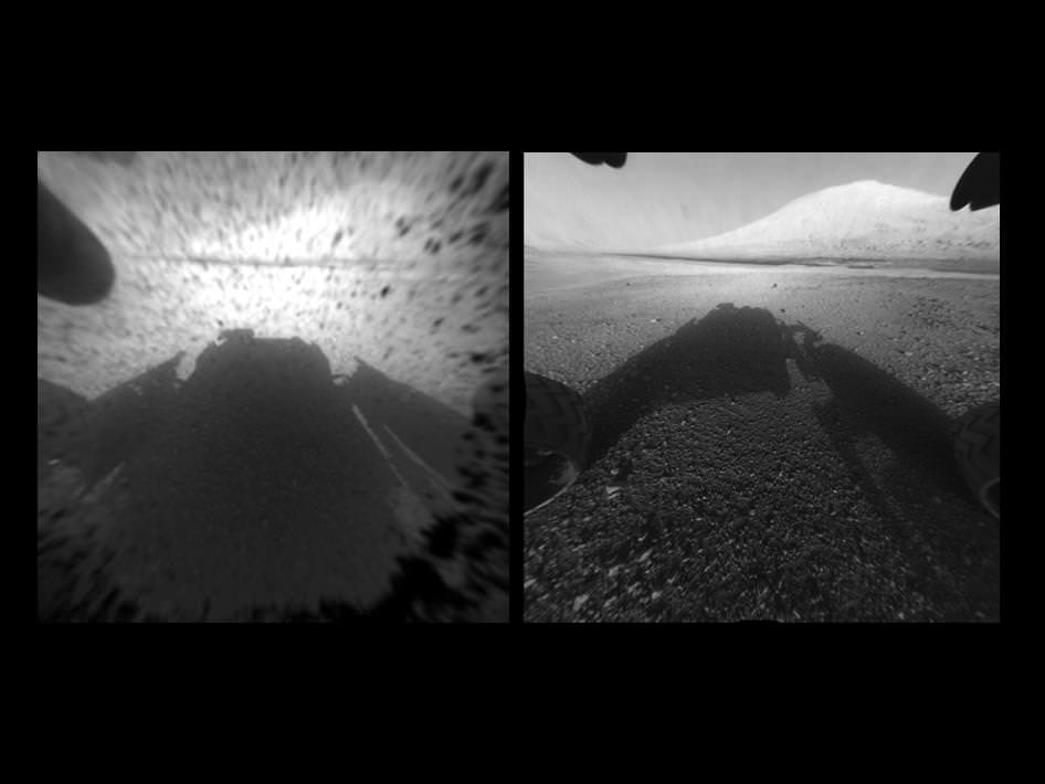
Image Caption: Clear View on Mars – This image comparison shows a view through a Hazard-Avoidance camera on NASA’s Curiosity rover before and after the clear dust cover was removed. Both images were taken by a camera at the front of the rover. Mount Sharp, the mission’s ultimate destination, looms ahead. See the first 3 D and 2 D full res images with no dust cover, below. Image credit: NASA/JPL-Caltech
Curiosity, NASA’s new car sized rover on Mars has sent back her first breathtaking views of Mount Sharp, the huge nearby mountain that enticed scientists to set Gale Crater as her touchdown goal.
And already within the first 2 Sols, or martian days, the rover has beamed back magnificent 2D and 3 D vistas of the landscape surrounding her.
The unprecedented rocket powered “Sky Crane” descent maneuver that lowered Curiosity by cables upon the Red Planet’s surface rover with pinpoint accuracy, set her down in a position inside Gale Crater that fortuitously pointed her front Hazard Avoidance (Hazcam) cameras towards a stupendous panoramic view of Mount Sharp.
The terrain is strewn with small pebbles that may stem from a nearby alluvial fan through which liquid water flowed long ago, scientist think.
The top image set shows the spectacular side by side views of Mount Sharp before and after the protective dust covers were popped off.
Mount Sharp is taller than Mount Ranier, the tallest mountain in the US in the lower 48 states. It’s about 3.5 miles (5.5 km) high.
Curiosity is roughly 6 km distant from Mount Sharp, as the martian crow flies.
The image below is the first full resolution Hazcam version of Mount Sharp.
Curiosity’s Early Views of Mars. This full-resolution image shows one of the first views from NASA’s Curiosity rover, which landed on Mars the evening of Aug. 5 PDT (early morning hours Aug. 6 EDT). It was taken through a “fisheye” wide-angle lens on one of the rover’s front Hazard-Avoidance cameras. These engineering cameras are located at the rover’s base. Image credit: NASA/JPL-Caltech
Here’s the first 3D version of Mount Sharp assembled from both front cameras.
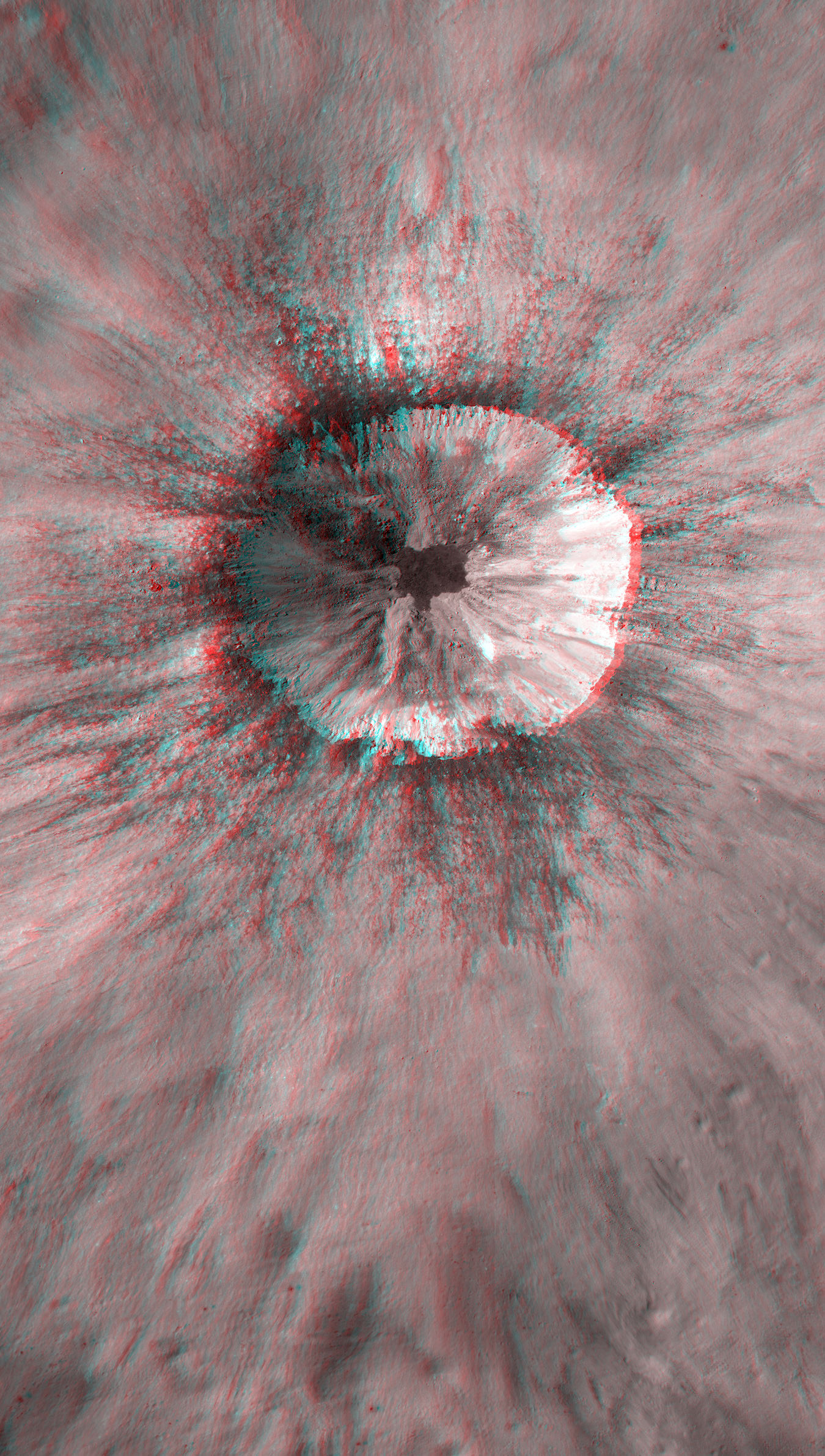
Image Caption: 3-D View from the Front of Curiosity. This image is a 3-D view in front of NASA’s Curiosity rover, which landed on Mars on Aug. 5 PDT (Aug. 6 EDT). The anaglyph was made from a stereo pair of Hazard-Avoidance Cameras on the front of the rover. Mount Sharp, a peak that is about 5.5 kilometers (3.4 miles) high, is visible rising above the terrain, though in one “eye” a box on the rover holding the drill bits obscures the view. This image was captured by Hazard-Avoidance cameras on the front of the rover at full resolution shortly after the rover landed. It has been linearized to remove the distorted appearance that results from its fisheye lens. Credit: NASA/JPL-Caltech
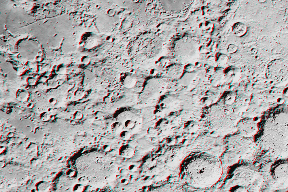
A young unnamed crater on the Moon west of Isaev crater. Credit: NASA/GSFC/Arizona State University; Anaglyph by Nathanial Burton-Bradford.
[/caption]
While many are hoping to see a larger-than-usual view of the Moon this weekend, here’s some great 3-D closeups courtesy of the Lunar Reconnaissance Orbiter and imaging wizard Nathanial Burton Bradford. This great 3-D view (Red/Cyan glasses needed) shows quite an interesting young impact crater on the Moon, (17.682°S, 144.408°E) west of Isaev crater. Click on the image for a larger view, and in 3-D you can dive right in and see all the nooks and crannies – what scientists call complex crater morphology.
Below you can view a Digital Terrain Model, or DTM of this same crater, and find the specifics of how deep the various parts of the crater are and other information critical to scientific investigations of the Moon.
Digital Terrain Model (DTM) of an unnamed crater in the farside highlands. Image is 3.2 km across. Credit: NASA/GSFC/Arizona State University.
Another recent view released by the LRO camera team is of impact melt deposit on another unnamed crater on nearside highlands (38.112°N, 53.052°E; northeast of Mare Tranquillitatis). Again, Nathanial Burton-Bradford provides a 3-D view, and amazingly, the crater walls appear deceptively steep in 3-D as opposed to the regular 2-D view:
3D anaglyph of rim impact melt deposit on Unnamed crater on nearside highlands (38.112°N, 53.052°E; northeast of Mare Tranquillitatis). Credit: NASA/GSFC/Arizona State University; anaglyph by Nathanial Burton-Bradford.
What is impact melt? “So much energy is released when an asteroid or comet slams into the Moon that some of target rock (the Moon) is melted,” wrote Lillian Ostrach on the LRCO website. “For large craters, such as Tycho or Copernicus, the impact event responsible for forming these craters was large enough to generate melt that coated and covered the crater floor, and ejected melt pooled and flowed outside the crater cavity.”
Ostrach says that LROC images show that impact melt is widespread and quite common to lunar impact craters — but as this image shows – take a close look to find channels, flows, and veneers across much of the region.
Here’s LROC’s regular view:
Impact melt started to flow back into the crater cavity before it solidified. Image width is 500 m, from the LROC Narrow Angle Camera. Credit: NASA/GSFC/Arizona State University.
Find out more about these recent LRO images on the LROC website, and see more of Nathanial’s photography handiwork at his DeviantArt page.
This AIPP image is a 1000-by-666-pixel section of the full-resolution 3-D map that Jeffrey Ambrozia will create, which will be a 5398-by-7000-pixel graphic. This shows Heinsius crater. Image courtesy Jeffrey Ambroziak.
[/caption]
Love 3-D images? Interested in maps? Want to explore the Moon? Then a new Kickstarter project may be just what you are looking for. Jeffrey Ambroziak, creator of a specialized 3-D map projection method, will be producing what he calls the first true 3-D map of the Moon, and he is offering space enthusiasts the chance to get either digital or paper copies of the map, created from recently released data from the Lunar Reconnaissance Orbiter. Interest in the project has skyrocketed, and while the goal of $5,000 has already been reached by more than double that amount, Ambroziak is now thinking of what more he can offer to backers of his PopView 3D Moon Map.
“We’re at a place now where you can do some interesting research on your own, and it doesn’t necessarily require a large institution,” Ambroziak said by phone. “I love the idea of using Kickstarter to give interested and passionate space aficionados the opportunity to work with us.”
The maps will include not only 3-D views of the Moon’s surface, but on the “front side” will be “National Geographic-style” graphics and information.
Ambroziak said the backers who fund his project will be instrumental choosing the mapping locations and the information that is included.
“This will be very a very collaborative effort to pick the things we will put on the front of the map and the areas that we actually map in 3-D,” he told Universe Today. “As the Kickstarter project description makes clear, we are going to leverage the knowledge of all involved to produce a map that is as informative as it is innovative while letting everyone experience our excitement as the project takes shape. And in the end, everyone gets a copy of the map!”
Ambroziak added, “In the current age with NASA’s budget cuts and the space agency looking towards private enterprise more, there is now a place for interested people to create very interesting and useful space products. We spend billions of dollars to gather incredibly beautiful data of the Moon and Mars and much of it just sits around. We are looking to do our part to bring this data to life, and I’m proof of that you don’t have to sit around and wait for NASA to make an image from LROC data. We don’t have to wait anymore, we can do it ourselves.”
Ambroziak has been overwhelmed that his project is so popular. “I love the idea of the feedback that I’m getting already from people who are so excited about this project,” he said. Most gratifying was a top level pledge of $1,200 from former astronaut and shuttle pilot William Readdy, pledged $1200 to the project who wished Ambroziak “godspeed” in the effort. “It’s pretty neat when astronauts see the importance of what is being attempted,” Ambroziak said.
His patented Ambroziak Infinite Perspective Projection (AIPP) is a map projection method used for three-dimensional stereo visualization of geographic data, which allows viewers to see precise representation of data in 3-D, no matter what angle or distance the image is being viewed. He detailed the method in his book, Infinite Perspectives: Two Thousand Years of Three-Dimensional Mapmaking, (Princeton Architectural Press, 1999) and has previously created 3-D maps of Antarctica and Mars, which have been displayed at museums such as the Peabody Museum of Natural History.
I asked Ambroziak how far along he was with the project.
“I have downloaded all of the LROC imagery and digital elevation information,” he said. “I have further processed the image data to stretch out the contrast, computed shadows from the digital elevation model, and mixed the computed shadows back into the imagery to improve appearances. AIPP is then applied as desired to create 3D images. Specifically, imagery and digital elevation data is combined in accordance with a few chosen AIPP parameters (vertical exaggeration, view plane elevation, etc.) to produce the AIPP map.”
But that is only the technical part of the project, as the “front side” of the maps will be more artistic.
“I will be able to poll the backers for their preferred area of interest,” he said. “In short, you back the project, you have a say in the mapping of the Moon! Ultimately, I would like to perform a systematic mapping of the entire surface of the Moon in accordance with the USGS quad-map nomenclature and format. This is just the first step. This is Kickstarter – not start and then end.”
Check out the Kickstarter page for the “prizes” or incentives are for the various levels of funding. They range from getting a digital copy emailed to you, to complete posters, to an invitation to dinner for you and a guest with the Ambroziak, with food and drinks on him.
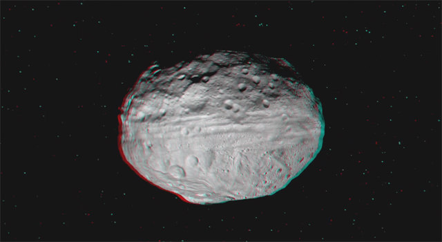
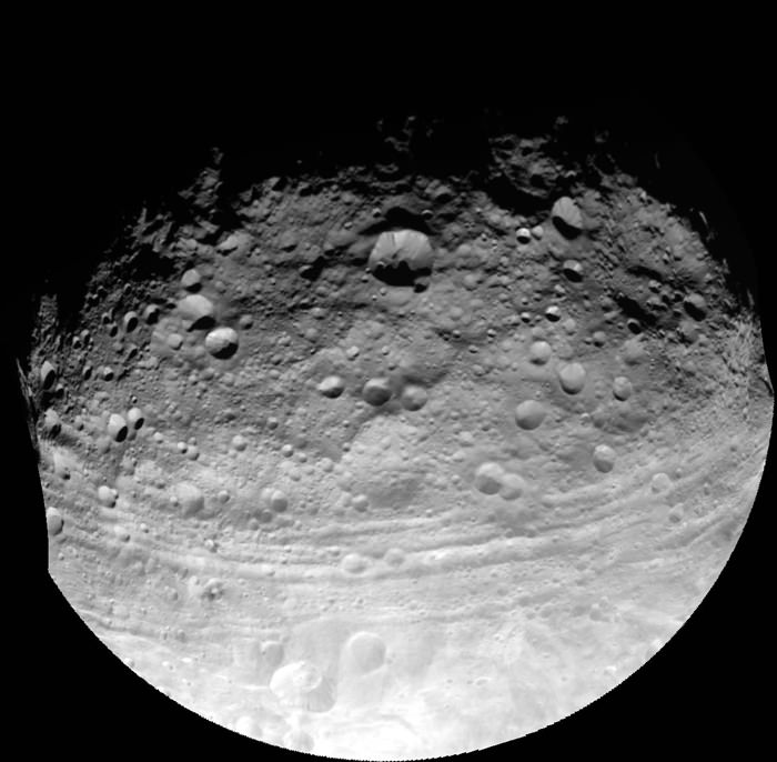
Vivid Vesta Vista in Vibrant 3 D from NASA’s Dawn Asteroid Orbiter. Vesta is the second most massive asteroid and is 330 miles (530 km) in diameter. Credit: NASA/JPL-Caltech/UCLA/MPS/DLR/IDA
[/caption]
It’s time to put on your 3-D glasses and go soaring all over the giant asteroid Vesta – thanks to the superlative efforts of Dawn’s international science team.
Now you can enjoy vivid ‘Vestan Vistas’ like you’ve never ever seen before in a vibrant 3 D video newly created by Dawn team member Ralf Jaumann, of the German Aerospace Center (DLR) in Berlin, Germany – see below.
To fully appreciate the rough and tumble of the totally foreign and matchless world that is Vesta, you’ll absolutely have to haul out your trusty red-cyan (or red-blue) 3 D anaglyph glasses.
Then hold on, as you glide along for a global gaze of mysteriously gorgeous equatorial groves ground out by a gargantuan gong, eons ago.
Along the way you’ll see an alien ‘Snowman’ and the remnants of the missing South Pole, including the impressive Rheasilvia impact basin – named after a Vestal virgin – and the massive mountain some 16 miles (25 kilometers) high, or more than twice the height of Mt. Everest.
Video Caption: This 3-D video incorporates images from the framing camera instrument aboard NASA’s Dawn spacecraft from July to August 2011. The images were obtained as Dawn approached Vesta and circled the giant asteroid during the mission’s survey orbit phase at an altitude of about 1,700 miles (2,700 kilometers). To view this video in 3-D use red-green, or red-blue, glasses (left eye: red; right eye: green/blue). Credit: NASA/JPL-Caltech/UCLA/MPS/DLR/IDA
“If you want to know what it’s like to explore a new world like Vesta, this new video gives everyone a chance to see it for themselves,” Jaumann said. “Scientists are poring over these images to learn more about how the craters, hills, grooves and troughs we see were created.”
NASA’s Dawn spacecraft is humanity’s first probe to investigate Vesta, the second most massive body in the main Asteroid Belt between Mars and Jupiter.
Video caption: 2 D rotation movie of Vesta. Compare the 2 D movie to the new 3 D movie. Credit: NASA/JPL-Caltech/UCLA/MPS/DLR/IDA.
Indeed Dawn was just honored by Popular Science magazine and recognized as one of three NASA Planetary Science missions to earn a ‘Best of What’s New in 2011’ for innovation in the aviation and space category – along with the Curiosity Mars Science Laboratory (MSL) and MESSENGER Mercury orbiter.
Asteroid Vesta and Mysterious Equatorial Grooves - from Dawn Orbiter
This full view of the giant asteroid Vesta was taken by NASA’s Dawn spacecraft on July 24, 2011, at a distance of 3,200 miles (5,200 kilometers). This view shows impact craters of various sizes and mysterious grooves parallel to the equator. The resolution of this image is about 500 meters per pixel. Credit: NASA/JPL-Caltech/UCLA/MPS/DLR/IDA
The images in the 3 D video were snapped between July and August 2011 as Dawn completed the final approach to Vesta, achieved orbit in July 2011 and circled overhead during the mission’s initial survey orbit phase at an altitude of about 1,700 miles (2,700 kilometers) in August.
How was the 3 D movie created?
“The Dawn team consists of a bunch of talented people. One of those talented people is Ralf Jaumann, Dawn co-Investigator from the DLR in Berlin,” Prof. Chris Russell, Dawn Principal Investigator, of UCLA, told Universe Today.
“Jaumann and the team behind him have stitched together the mosaics we see and they have made shape models of the surface. They are also skilled communicators and have been heroes in getting the Dawn Image of the Day together. I owe them much thanks and recognition for their efforts.”
“They wanted to make and release to the public an anaglyph of the rotating Vesta to share with everyone the virtual thrill of flying over this alien world.”
“I hope everyone who follows the progress of Dawn will enjoy this movie as much as I do.”
“It is just amazing to an old-time space explorer as myself that we can now make planetary exploration so accessible to people all over our globe in their own homes and so soon after we have received the images,” Russell told me.
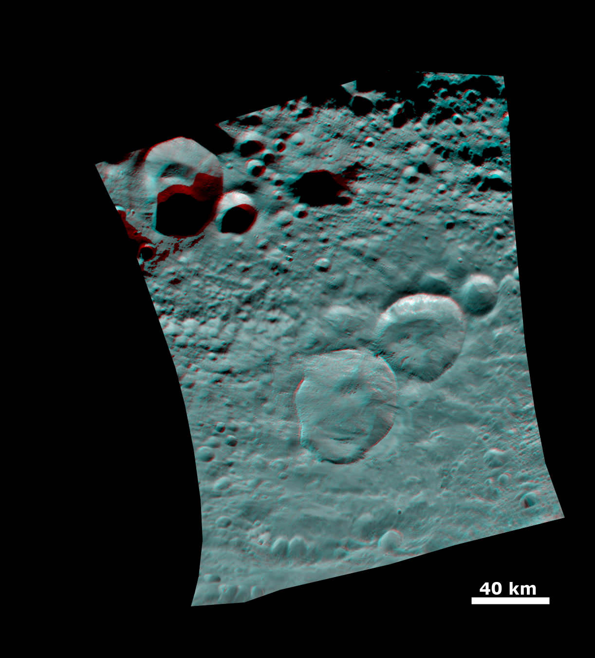
3 D of the ‘Snowman' Crater
This anaglyph image shows the topography of Vesta's three craters, informally named the "Snowman," obtained by the framing camera instrument aboard Dawn on August 6, 2011. The camera has a resolution of about 260 meters per pixel.
Credit: NASA/JPL-Caltech/UCLA/MPS/DLR/IDA
Dawn is now spiraling down to her lowest mapping orbit known as LAMO (Low Altitude Mapping Orbit), barely 130 miles (210 kilometers) above Vesta’s surface.
“Dawn remains on course and on schedule to begin its scientific observations in LAMO on December 12,” says Dr. Marc Rayman, Dawn’s Chief Engineer from the Jet Propulsion Lab (JPL), Pasadena, Calif.
“The focus of LAMO investigations will be on making a census of the atomic constituents with its gamma ray and neutron sensors and on mapping the gravity field in order to determine the interior structure of this protoplanet.”
“Today, Dawn is at about 245 km altitude,” Rayman told Universe Today.
The 3 D video is narrated by Carol Raymond, Dawn’s deputy principal investigator at JPL.
“Dawn’s data thus far have revealed the rugged topography and complex textures of the surface of Vesta, as can be seen in this video”.
“Soon, we’ll add other pieces of the puzzle such as the chemical composition, interior structure, and geologic age to be able to write the history of this remnant protoplanet and its place in the early solar system.”
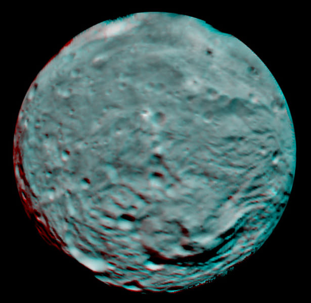
3 D Image of Vesta's South Polar Region
This anaglyph image of the south polar region was taken on July 9, 2011 by the framing camera instrument aboard NASA's Dawn spacecraft. Each pixel in this image corresponds to roughly 2.2 miles (3.5 kilometers). The anaglyph image shows the rough topography in the south polar area, the large mountain, impact craters, grooves, and steep scarps in three dimensions.
Credit: NASA/JPL-Caltech/UCLA/MPS/DLR/IDA
Read continuing features about Dawn by Ken Kremer starting here:
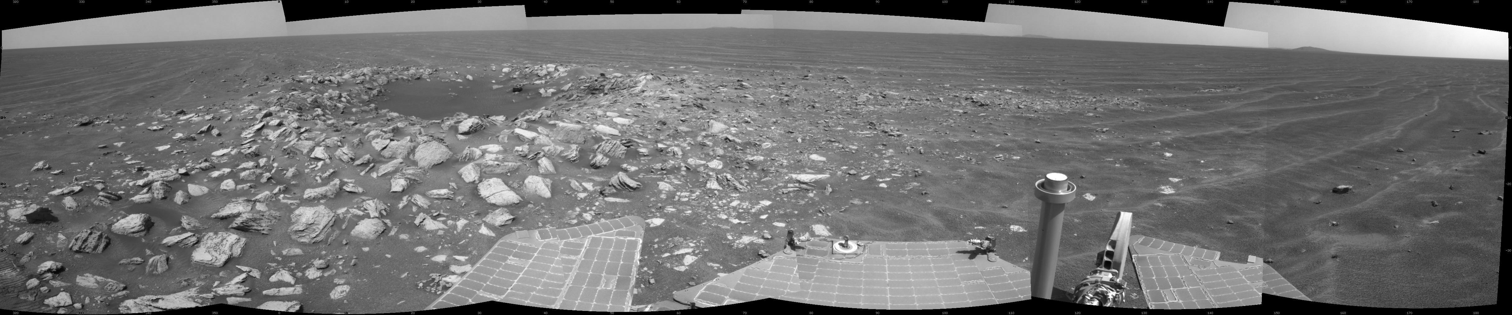
The 7 Year and 30 Kilometer Long Journey of Opportunity to June 1, 2011. This collage of martian surface mosaics and orbital maps shows the entire route traversed by NASA’s Opportunity Mars Rover from landing on Jan 24, 2004 to surpassing the 30 kilometer driving mark on June 1, 2011(see map notation). Opportunity is on an overland expedition driving to Endeavour Crater, some 22 km in diameter. Photo mosaic of Santa Maria crater at bottom shows one of the last spots investigated by Opportunity on Sol 2519, Feb. 23, 2011 before departing for Endeavour in March 2011. The exposed rock named Ruiz Garcia showed signatures of hydrated mineral deposits located at southeast portion of Santa Maria crater. Credit: NASA/JPL/Cornell Marco Di Lorenzo, Kenneth Kremer
[/caption]
With her most recent drive of 482 feet (146.8 meters) on June 1, 2011 (Sol 2614), NASA’s Opportunity Mars Rover has zoomed past the unimaginable 30 kilometer (18,64 miles) mark in total odometry since safely landing on Mars nearly seven and one half years ago on Jan 24, 2004. That’s 50 times beyond the roughly quarter mile of roving distance initially forseen.
Opportunity is now 88 months into the original 3 month mission “warranty” planned by NASA and the rover team. That’s over 29 times beyond the original design lifetime and an achievement that no one on the rover teams ever expected to observe.
And Opportunity is still going strong, in good health and has abundant solar power as she continues driving on her ambitious overland trek across the martian plains of Meridiani Planum. She is heading to the giant Endeavour crater, some 22 km (14 miles) in diameter.
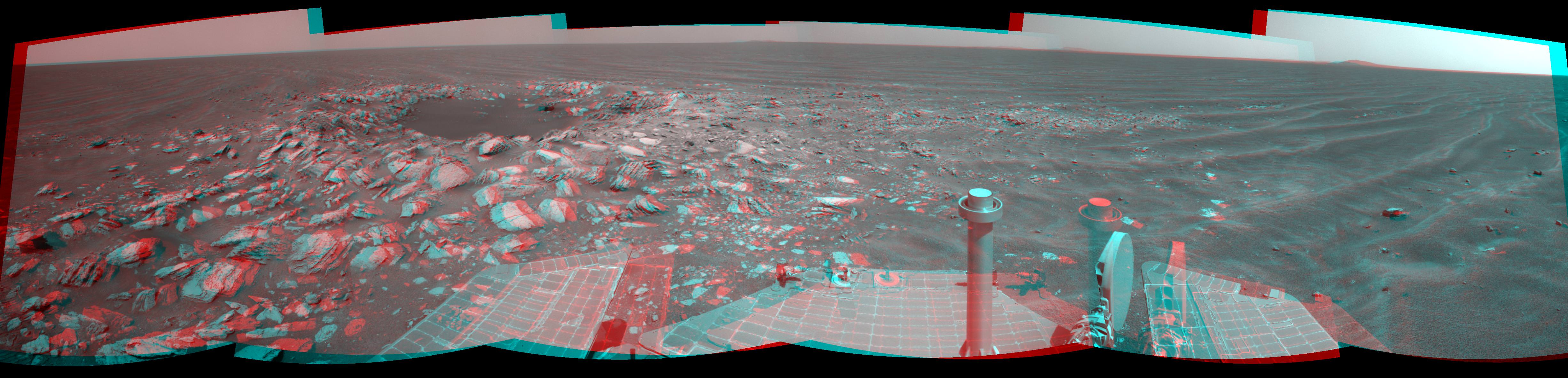
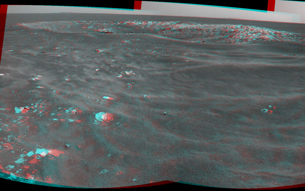
Opportunity snaps Skylab Crater in 3 D during approach to Endeavour Crater
This stereo view of Skylab Crater was captured by Opportunity on Mars on Sol 2594, or May 12, 2011, along the rovers route to giant Endeavour Crater. This young crater is about 30 feet (9 meters) in diameter.and was likely formed within the past 100,000 years. Credit: NASA/JPL-Caltech
At this point Endeavour is barely 2 miles (3.5 km) away since Opportunity departed from Santa Maria Crater in March 2011. Landfall at Endeavour is expected sometime later this year.
Endeavour is a long awaited and long sought science target because it is loaded with phyllosilicate clay minerals. These clays have never before been studied and analyzed first hand on the red planets surface.
Opportunity snaps Skylab Crater in 2 D during approach to Endeavour Crater
This view of Skylab Crater was captured by Opportunity’s navigation camera on Mars on Sol 2594, or May 12, 2011, along the rovers route to giant Endeavour Crater. This young crater is about 30 feet (9 meters) in diameter. The blocks of material ejected from the crater-digging impact sit on top of the sand ripples near the crater. This suggests, from the estimated age of the area's sand ripples, that the crater was formed within the past 100,000 years. The dark sand inside the crater attests to the mobility of fine sand in the recent era in this Meridiani Planum region of Mars. The rover view spans 216 degrees from northwest on the right to south on the right. Credit: NASA/JPL-Caltech
Phyllosilicate clays formed in neutral watery environments, which are much more conducive to the formation of life compared to the highly acidic environments studied up to now by Spirit and Opportunity. NASA’s Curiosity rover is due to land on Mars in 2012 at a site the science team believes is rich in Phyllosilicates.
In recent weeks, Opportunity has passed by a series and small young craters as she speeds to Endeavour as fast as possible. One such crater is named “Skylab”, in honor of America’s first manned Space Station, launched in 1973.
Now whip out your 3 D glasses and check out NASA’s newly released stereo images of “Skylab” and another named “Freedom 7” in honor of Alan Shepard’s flight as the first American in space. Be sure to also view Opportunity’s dance steps in 3 D performed to aid backwards driving maneuvers on the Red planet
Freedom 7 Crater on Mars 50 Years after Freedom 7 Flight
Opportunity recorded this stereo view of a crater informally named Freedom 7 shortly before the 50th anniversary of the first American in space: astronaut Alan Shepard's flight in the Freedom 7 spacecraft on May 5, 1961. Opportunity took this image on Sol 2585 on Mars on May 2, 2011. The crater is about 25 meters (82 feet) in diameter. It is the largest of a cluster of about eight craters all formed just after an impactor broke apart in the Martian atmosphere perhaps 200,000 years ago. Credit: NASA/JPL-Caltech
“Skylab” is about 9 meters (30 feet) in diameter. The positions of the scattered rocks relative to sand ripples suggest that Skylab is young for a Martian crater. Researchers estimate it was excavated by an impact within the past 100,000 years.
“Freedom 7” crater is about 25 meters (82 feet) in diameter. During her long overland expedition, Opportunity is examining many craters of diverse ages at distant locales to learn more about the past history of Mars and how impact craters have changed over time.
Opportunity was just positioned at a newly found rock outcrop named “Valdivia” and analyzing it with the robotic arm instruments including the Microscopic Imager and the Alpha Particle X-ray Spectrometer (APXS).
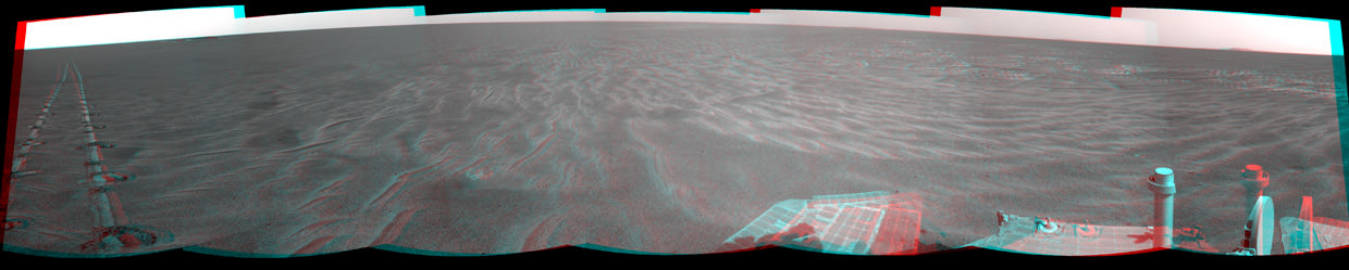
Opportunity leaves dance step on Mars
A dance-step pattern is visible in the wheel tracks near the left edge of this scene recorded in stereo by the navigation camera during Sol 2554 on Mars (April 1, 2011). The pattern comes from use of a new technique for Opportunity to autonomously check for hazards in its way while driving backwards. For scale, the distance between the parallel tracks of the left and right wheels is about 1 meter (about 40 inches). Credit: NASA/JPL-CaltechSkylab, America’s First manned Space Station
Photo taken by departing Skylab 4 crew in Feb. 1974. Credit: NASA
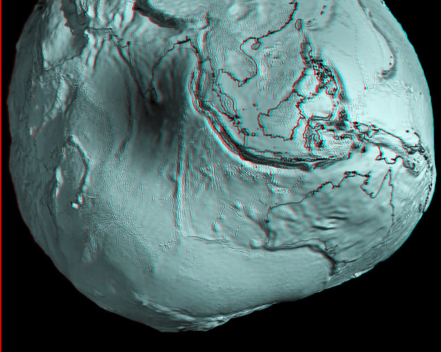
Australia and Asia region of Earth's geoid. Credits: ESA/HPF/DLR, anaglyph by Nathanial Burton-Bradford.
[/caption]
Grab your red/cyan 3-D glasses and take a look at these marvelous new anaglyphs created by Nathanial Burton-Bradford from the latest data from GOCE satellite, showing Earth’s gravity field – or geoid. The geoid is essentially a map of the shape our world would be its surface were covered by water and if gravity were the only thing shaping this global ocean’s surface. These exaggerated views (the surface in the images of the geoid is amplified by a factor 7,000) show the most accurate model of how gravity varies across the planet. Nathanial was able to obtain high-resolution video from Dr. Rune Floberghagen of the GOCE team from which he extracted appropriate frames in order to construct hi-res anaglyph images of numerous longitudes across the globe.
In our previous article about GOCE (Gravity Field and Steady-State Ocean Circulation Explorer), we showed the entire globe and how it looks like a spinning potato. Nathanial’s anaglyphs show close-ups of various parts of the globe. Above is Australia and Asia. Take a trip around the GOCE geoid 3-D world below. Remember, use the red/cyan 3-D glasses to get the full effect!
GOCE view of South America. Credits: ESA/HPF/DLR, anaglyph by Nathanial Burton-Bradford.
GOCE view of the US and Mexico. Credits: ESA/HPF/DLR, anaglyph by Nathanial Burton-Bradford.GOCE view of Europe. Credits: ESA/HPF/DLR, anaglyph by Nathanial Burton-Bradford.GOCE view of Africa.. Credits: ESA/HPF/DLR, anaglyph by Nathanial Burton-Bradford.GOCE global view, 145 East Longitude. Credits: ESA/HPF/DLR, anaglyph by Nathanial Burton-Bradford.GOCE global view, 140 West Longitude. Credits: ESA/HPF/DLR, anaglyph by Nathanial Burton-Bradford.
Developing coronal holes. Two coronal holes that develop over several days stand out in this image taken of the Sun from SDO's AIA instrument on Jan. 12, 2010. Coronal holes are areas of the Sun's surface that are the source of open magnetic field lines that head way out into space. Credit: NASA
[/caption]
A pair of coronal holes on the Sun newly imaged by NASA’s flagship solar probe, the Solar Dynamics Observatory (SDO) may cause auroral activity here on Earth soon.
The pair of holes were captured in images taken from Jan 9-12, 2011 by SDO’s AIA instrument in the extreme untraviolet (UV). The images – shown above and below – were also made into a cool timelapse video (shown below) of the rotating sun and were released by NASA as “SDO Pick of the Week” for Jan. 14, 2011.
SDO research results on the solar corona are featured as the cover photo and story for the current issue of Science magazine on Jan. 7, 2011. Updated
Science magazine Jan. 7 2011, COVER.
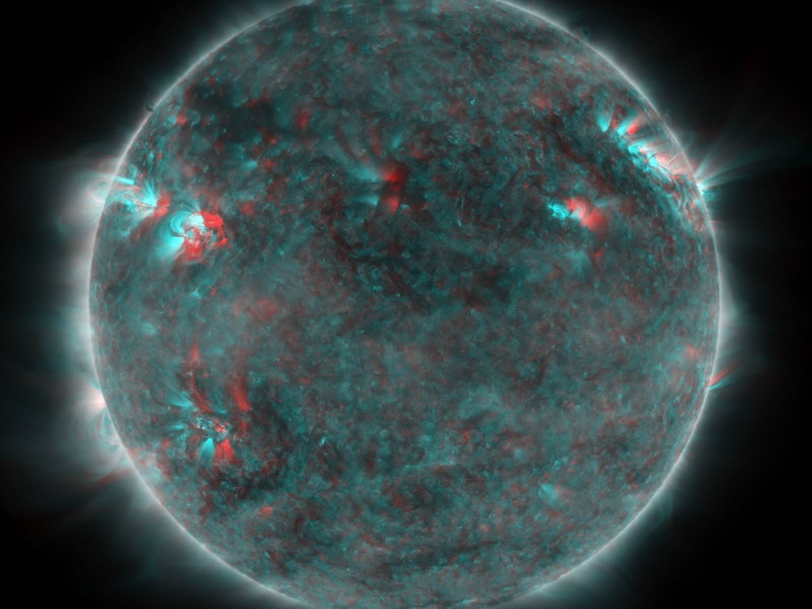
Multiwavelength extreme ultraviolet image of the Sun taken by the Solar Dynamics Observatory's Atmospheric Imaging Assembly. Colors represent different gas temperatures: ~800,000 kelvin (K) (blue), ~1.3 million K (green), and ~2 million K (red). New observations reveal a link between hot plasma and jets propelled upward from the region immediately above the Sun's surface and help explain why the Sun's outer atmosphere, or corona, is much hotter than its surface. Image: NASA/Solar Dynamics Observatory/Atmospheric Imaging Assembly (AIA)
Click to enlarge all images
Coronal holes on the sun’s surface are the source of open magnetic field lines and are areas from which high-speed solar wind particles stream out into space. The fast solar wind travels at approximately 800 km/s (about 1.8 million mph). After traveling through space for a few days the particles will impact the Earth and may spark the formation of some auroral activity for lucky spectators.
The two holes developed over several days. In a video here, one hole is above the suns equator and the other is below. According to a NASA press release, the coronal holes appear dark at the extreme UV wavelength of 193 Angstroms because there is just less of the material – ionized iron- that is being imaged.
2 D Video: A Hole in the Sun’s Corona
Caption: This timelapse video shows a coronal hole, as captured in ultraviolet light by NASA’s Solar Dynamics Observatory around Jan. 10, 2011. Coronal holes are areas of the sun’s surface that are the source of open magnetic field lines that head way out into space. They are also the source regions of the fast solar wind, which “blows” at a relatively steady clip of 1.8 million mph. (No audio). Credit: NASA
3 D Video: Coronal holes from STEREO
Check out this 3 D movie of a coronal hole snapped by NASA’s twin STEREO solar probes orbiting the sun. You’ll need to pull out your red-cyan 3 D anaglyph glasses. First, watch the short movie with you 3 D glasses. Then, I suggest to pause the movie at several intervals for a longer look. Remember – its red on the left eye.
Caption: This STEREO image features an active region and a coronal hole. The hole is the large dark spot in the middle of the sun. Coronal holes are the source of solar wind and a generator for space weather activity. Credit: NASA
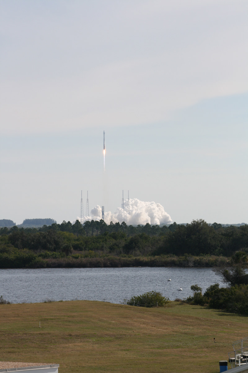
SDO roared to space on February 11, 2010 atop a powerful Atlas V rocket from Cape Canaveral Air Force Station in Florida. Launch photo below.
The billion dollar probe is the “crown jewel” in NASA’s solar fleet and will soon celebrate its first anniversary in space. SDO’s mission is to explore the Sun and its complex interior mechanisms in unprecedented detail. It is equipped with three science instruments (HMI, AIA, and EVE)
This Solar Dynamics Observatory image of the Sun taken on January 10, 2011 in extreme ultraviolet light captures a dark coronal hole just about at sun center. Coronal holes are areas of the Sun's surface that are the source of open magnetic field lines that head way out into space. Credit: NASASDO blast off on Feb. 11, 2010 atop Atlas V rocket from Pad 41 at Cape Canaveral as viewed from the KSC press site. Credit: Ken KremerSolar 3 D in Extreme UV - from SDO.
This 3 D image was created by combined two images that were taken in one extreme UV wavelength about 8 hours apart on June 25, 2010. The Sun's rotation created enough of a perspective change for this to work. Although the SDO mission cannot produce true 3D images of the Sun like STEREO, 3D solar images can still be made from SDO images. Credit: NASA/SDO