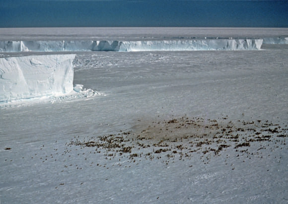
An emporer penguin colony at Halley Bay. Credit: British Antarctic Survey
This just in from the ‘things kids can giggle about’ department: British scientists are using satellite images to find colonies of emperor penguins in Antarctica. While their natural camouflage makes them blend into the shadows of the sea ice where they breed, their droppings, or guano, show up perfectly from space. “We can’t see actual penguins on the satellite maps because the resolution isn’t good enough,” said mapping expert Peter Fretwell. “But during the breeding season the birds stay at a colony for eight months. The ice gets pretty dirty and it’s the guano stains that we can see.”
Stains on the ice visible on this satellite image. Credit: British Antarctic Survey
Emperor penguins spend a large part of their lives at sea. During the Antarctic winter when temperatures drop to -50°C they return to their colonies to breed on sea-ice, but this is a time when it is most difficult for scientists to monitor them. Knowing their location provides a baseline for monitoring their response to environmental change.
Reddish brown patches of guano on the ice, visible in satellite images, provide a reliable indication of their location.
British Antarctic Survey Penguin ecologist Dr Phil Trathan says: “This is a very exciting development. Now we know exactly where the penguins are, the next step will be to count each colony so we can get a much better picture of population size. Using satellite images combined with counts of penguin numbers puts us in a much better position to monitor future population changes over time.”
The method helped scientists identify 38 penguin colonies — of those, 10 were new. Of previously known colonies, six had re-located and six were not found. Estimates put the total number of penguins at between 200,000 and 400,000 breeding pairs.
[/caption]
Mount Stromboli is an active volcano on a small island off the north coast of Sicily – one of three active volcanoes in Italy. The volcano itself rises 924 meters above sea level, but it actually rises 2,000 meters from the floor of the ocean. It is one of the most active volcanoes in the world, erupting almost continuously for the last 2,000 years.
The eruptions of Stromboli are seen best at night, when chunks of lava blasted out of the volcano trace bright red arcs in the sky. In fact, it’s such an iconic type of eruption that geologists have named an entire class of eruptions after Mount Stromboli. Whenever you get a volcano blasting out blobs of hot lava, gas and rocks in arcs from its volcanic vent, that’s a strombolian eruption. This kind of eruption has been seen in volcanoes worldwide.
The largest (recent) eruption on Mount Stromboli happened in 1930, and resulted in the deaths of several people and the destruction of several homes. Large eruptions like this happen every decade or so. With such regular and predictable volcanic activity, tours used to go up the side of Mount Stromboli at night; the best time to see the beautiful arcs of lava. But in 2007 two new craters opened up on the island, and made the volcano less predictable. Tourists have been banned from going up to the summit to watch the volcano.
You might be surprised to know that there are 400 to 750 people living on the island of Stromboli, in the shadow of the volcano.
We have written many articles about volcanoes for Universe Today. Here’s an article about Mount Etna, and here’s an article about Mount Vesuvius; the two other active volcanoes in Italy.
[/caption]
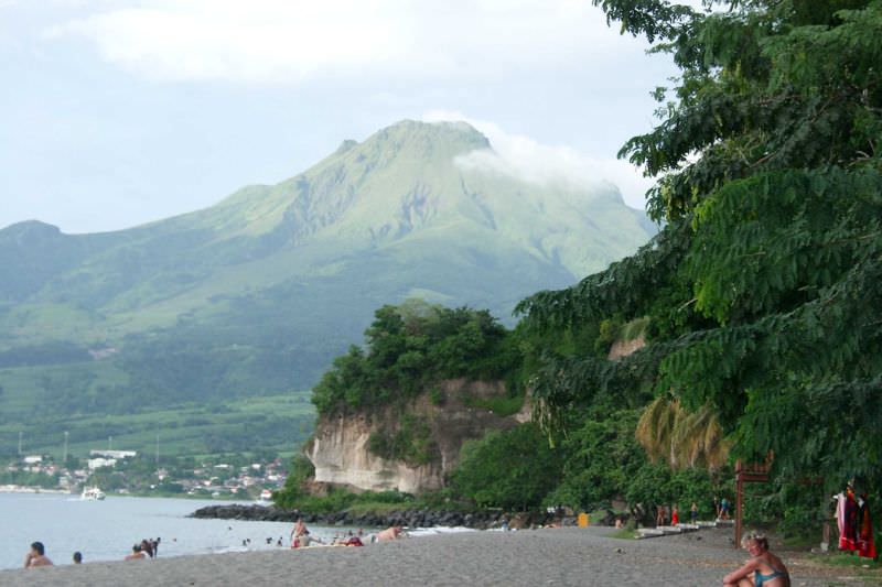
Mount Pelee, on the island of Martinique in the Caribbean is one of those volcanoes with such a famous and devastating eruption, that a whole class of eruptions has been named after it. In 1902, it was the source of the worst volcanic disaster of the 20th century when a pyroclastic flow blasted down its flanks and killed more than 30,000 people destroying the town of Saint-Pierre.
The volcano has an elevation of 1,397 meters, and is part of a chain of volcanoes that stretch from Puerto Rico to Venezuela. This is the point where the Caribbean Plate Meets the Atlantic Oceanic crust belonging to the South American Plate. With all this tectonic action, there are many active volcanoes in the region. Mount Pelee is a common stratovolcano, composted of many layers of lava flows and fragmented volcanic debris. The current cone formed in the last 3000 years after a previous cone collapsed in an eruption similar to Mount St. Helens.
Inhabitants of Martinique could see evidence that Mount Pelee was awakening in 1900 when activity on the volcano increased. There were relatively minor steam eruptions, and there were several minor blasts of cinders and ash. There were several larger eruptions, but these were just setting the stage for the big eruption on May 8, 1902. Observers saw the side of Mount Pelee detonate, with a dense black cloud of ash shooting out horizontally. This sent a pyroclastic flow down the slopes of the volcano, reaching and destroying the town of Saint-Pierre within a minute.
Vulcanologists have named an entire class of eruptions after what happened on Mount Pelee. Pelean eruptions describe when a volcano has a horizontal explosion on its flanks, sending out pyroclastic flows. They’re some of the most dangerous eruptions in the world.
We have written many articles about volcanoes for Universe Today. Here’s an article about pelean eruptions, and here’s an article about Mount Pinatubo.
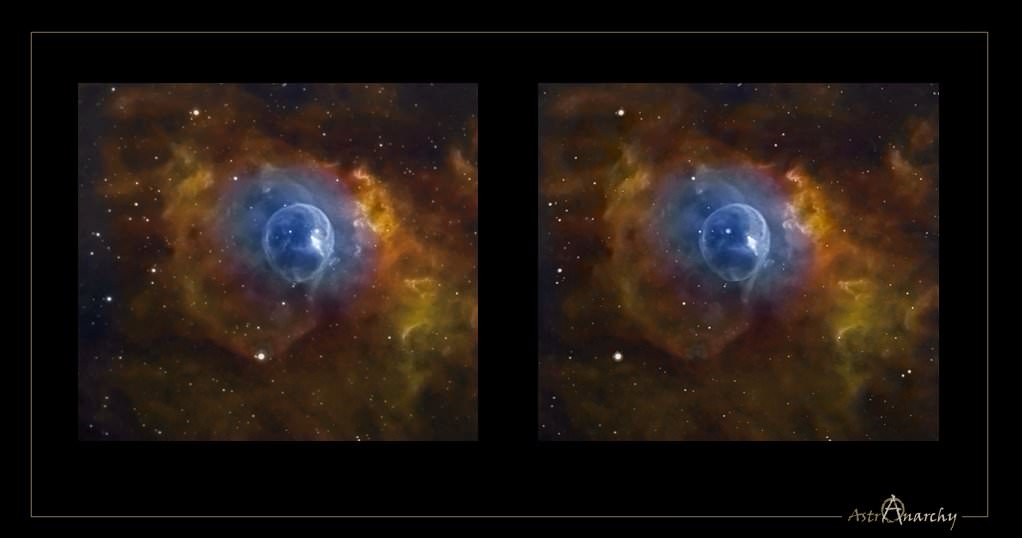
Away in the constellation of Cassiopeia some 7,100 light-years from Earth, a star 40 times more massive than our Sun is blowing a giant bubble of its own material into space. Inside its magic blue sphere, the gigantic star burns at blue flame intensity – rendering a 6 light year wide envelope of hot gas around it that’s expanding outward at a speed of 4 million miles per hour. Are you ready to open wide and step inside? Then welcome to a little dimensional magic….
As always, whenever we present a dimensional visualization it is done in two fashions. The first is called “Parallel Vision” and it is much like a magic eye puzzle. When you open the full size image and your eyes are the correct distance from the screen, the images will seem to merge and create a 3D effect. However, for some folks, this doesn’t work well – so Jukka has also created the “Cross Version”, where you simply cross your eyes and the images will merge, creating a central image which appears 3D. For some folks, this won’t work either… But I hope it does for you!
NGC 7635 Cross Vision by JP Metsavainio
As the central star in NGC 7635 sheds its material, we can see it isn’t even and its appearance varies with the thickness of the surrounding gases. What appears to be cloud-like structures are very thick and illuminated by the star’s intense ultraviolet light. Believe it or not, it is here where the stellar “winds” blow the fastest and it won’t be long until these areas quickly erode. However, there is one feature that stands out more than any other – the “bubble-within-a-bubble”. What is it? It may be two distinct winds… Two distinct streamers of material colliding together.
“The bubble in NGC 7635 is the result of a fast stellar wind expanding into the interior of the larger H II region. However, the central star BD +60 2522 is appreciably offset (by about 1′) from the center of the bubble in the direction of the wall of the dense molecular cloud that defines this blister H II region.” says B.D. Moore (et al), “This offset is the result of evolution of the wind bubble into the density and pressure gradient established by the photoevaporative flow away from the cavity wall. The physical conditions around the bubble vary according to the medium into which the bubble is expanding. Away from the cavity wall the bubble is expanding into the low density interior of the H II region. Toward the wall, in the region of our images, the wind termination shock is very near the ionization front. The resulting physical structure, in which the photoevaporative flow away from the cloud wall is confined by the ram pressure of the wind.”
But, are we not seeing the proverbial forest because we’re too busy looking at the trees? “BD +60 is the ionizing star of NGC 7635, the so-called “Bubble Nebula”. NGC 7635 lies at the edge of a low-density clumpy molecular cloud and the nebula can be interpreted as a wind-blown bubble created by the interaction of the stellar wind of BD +60 with the ambient interstellar medium. While many investigations have focused on the nebula, little attention has been paid to the star itself.” says G. Rauw (et al), “Considerable progress in our understanding of the stellar winds of early-type stars has been achieved through extensive monitoring of their spectroscopic variability and the discovery that some of the cyclical variations could be related to a rotational modulation of the stellar wind. Since rotation is believed to shape the winds of Oef stars, these objects appear a priori as good candidates to search for a rotational wind modulation.”
Throughout their long term observing campaign, the group found strong profile variability on time scales of 2–3 days, variability on time scales of a few hours that might be related to non-radial pulsations, and even tentatively propose that the beating of several non-radial pulsation modes triggers transient large-scale density perturbations in a confined stellar wind that produce the 2–3 day time scale variability. “While this scenario could easily account for the lack of a single stable period (through the effect of the propagation velocity of the perturbation and the interplay of various clocks: pulsations, rotation…), it seems more difficult to explain the changing pattern of the TVS. For instance, if a density wave moves around the star, why would it not affect the absorption and the emission components in a similar manner?” says Rauw, “One possibility could be that the density perturbation affects the absorption column only as long as it remains close to the stellar surface whilst the impact on the emission lines would be larger when the perturbation has moved outwards, but this is admittedly still rather speculative.”
Just how common is it for a huge star to form a bubble around itself? “Massive stars evolve across the HR diagram, losing mass along the way and forming a variety of ring nebulae. During the main sequence stage, the fast stellar wind sweeps up the ambient interstellar medium to form an interstellar bubble. After a massive star evolves into a red giant or a luminous blue variable, it loses mass copiously to form a circumstellar nebula. As it evolves further into a WR star, the fast WR wind sweeps up the previous mass loss and forms a circumstellar bubble. Observations of ring nebulae around massive stars not only are fascinating, but also are useful in providing templates to diagnose the progenitors of supernovae from their circumstellar nebulae.” says You-Hua Chu of the University of Illinois Astronomy Department, “The fast stellar wind of a main sequence O star sweeps up the ambient interstellar medium (ISM) to form an interstellar bubble, which consists of a dense shell of interstellar material. Intuitively, we would expect around most O stars an interstellar bubble similar to the Bubble Nebula (NGC 7635) to be visible; however, hardly any O stars in HII regions have ring nebulae, suggesting that these interstellar bubbles are rare.”
Like a child chewing gum, the bubble will continue to expand. And what comes after the bubble? Why, the “bang” of course. And when it comes to a star going bang, than can only mean a supernova. “By pursuing the calculation through the various stages of massive star evolution, using a realistic mass loss history as input, we simulate the creation and evolution of a wind-blown bubble around the star up to the time of the supernova explosion.” says A. J. van Marle (et al), “The outflowing matter encounters an inner shock, where its velocity is reduced to nearly zero. The kinetic energy of the wind becomes thermal energy. This interaction creates a “hot bubble” of nearly stationary, hot gas. The thermal pressure of the hot bubble drives a shell into the surrounding interstellar medium. Here it is assumed, that the pressure driven shell will be restrained only by the ram pressure created by its own velocity and the density of the surrounding medium. This assumption is correct if we consider the surrounding medium to be cold. However, if we take photo-ionization into account the situation becomes rather more complicated. First of all, the photoionized gas will have a much higher pressure than the cold ISM. Therefore, the HII region will expand, driving a shell into the ISM. Second, the hot-bubble created by the stellar wind will now expand into a hot HII region, which means that the thermal pressure restraining the shell, will no longer be negligible compared to the ram pressure. A wind-blown bubble expanding into a compact HII region can be observed in NGC 7635.”
So how do we know when the final moments have come? “As the star ages, it becomes a red supergiant with a dense and slow wind. The number of ionizing photons drops. Therefore, the HII region disappears. Owing to the low density, recombination will take a long time, but radiative cooling will cause a decrease in thermal pressure. The hot wind-bubble, which keeps its high pressure, expands into the surrounding gas, creating a new shell. A third shell appears close to the star, as the drop in ram pressure from the RSG wind causes the wind bubble to expand inward, sweeping up the wind material.” say van Marle, “The presence of an expanding HII region changes the density structure of the nebula during the main sequence. Our main goal at this time is to simulate the circumstellar environment of stars between 25 M and 40 M at the time of the supernova explosion.”
Magic bubbles? Just stay out of the way when they pop!
Many thanks to JP Metsavainio of Northern Galactic for his magical personal image and allowing us this incredible look at distant beauty!
[/caption]
At any time there are about 20 volcanoes actively erupting around the world, and about 50-70 volcanoes have erupted in the last year or so. There are a total of 550 volcanoes that have erupted in all of recorded history. Some of these active volcanos are extremely famous, often because of a tremendous loss of life. Here’s a list of some famous volcanoes:
Caribbean
Mount Pelee – A stratovolcano on the island of Martinique that killed more than 30,000 people during an eruption in 1902.
Cotopaxi – A very active volcano in Ecuador, popular with hikers.
Chimborazo – This dormant stratovolcano is the highest point in Ecuador, and actually the most distant point from the center of the Earth.
Cayambe – Another dormant stratovolcano in Ecuador. It’s the third tallest peak in the country.
Greece
Thera – The volcano that devastated the island of Santorini; one of the most powerful volcano eruptions in recorded history.
Indonesia
Krakatoa – This used to be an island in the Sunda Strait near the island of Java. It exploded in 1883 creating one of the largest eruptions in recorded history.
Mount Tambora – A stratovolcano on the island of Sumbawa in Indonesia. It exploded in 1815 producing the most powerful eruption in recorded history.
Mount Merapi – An active volcano in Indonesia, on the island of Java near the city of Yogyakarta. It’s so active that ash is almost constantly coming out the top of the volcano, and it has had several recent devastating eruptions.
Italy
Mount Etna – An active volcano on the Island of Sicily. It’s in an almost constant state of eruption, with huge ash clouds visible from the island.
Mount Vesuvius – A dangerous volcano near Italian city of Naples. It’s most famous for the devastating eruption in AD 79 that destroyed the towns of Pomeii and Herculaneum.
Mount Stromboli – An active volcano just off the coast of Sicily. It has been constantly erupting for the last 2,000 years or so.
Japan
Mount Fuji – The iconic Japanese stratovolcano – the highest point in Japan.
Mauna Loa – This active shield volcano is the second tallest volcano in the world, but it’s the biggest volcano in the world, with the most volume. It has erupted within the last century.
Hualalai – The third most active volcano in Hawaii.
Kilauea – An active volcano on the eastern side of the Island of Hawaii. It’s in an almost constant state of eruption, and one of the most active volcanoes in the world.
Kohala – The oldest of the 5 volcanoes on the Big Island of Hawaii.
Mauna Kea – The tallest volcano in the world, located on the Big Island of Hawaii.
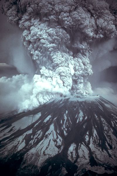
Mount St. Helens – An active volcano in Washington State. It detonated in 1980, destroying thousands of square km of forest and killed 57 people.
Mount Mazama – This is the name for the stratovolcano that exploded more than 7000 years ago, creating what is now Crater Lake in Oregon.
Mount Rainier – An active stratovolcano that dominates the skyline over Seattle. 150,000 people live on mudflows that erupted out of the volcano 5,000 years ago.
[/caption]
Looking to go somewhere far-flung and exotic? Now is the time to book your excursion, and the Cassini spacecraft has several flyby tours of the moons Titan and Enceladus scheduled for the next few months. Major tour operators say the cost of long-haul flights and summer holidays prices are at an all time low. But with Cassini, you can travel for FREE! just by following the along with Universe Today and the Cassini website. Thrill with some of the closest flybys ever of the mystery moon Titan, and delight in explorations of the geyser plumes of Enceladus. As a special bonus, if you book today, you can experience Saturn’s solar equinox, as in August the sun crosses from the southern hemisphere to the north. Wonderful worlds are beckoning – come away starting June 6 with Cassini! It’s a worry free vacation. See below for available tour dates! Destination fees do not apply.
Seriously now, here are the upcoming dates scheduled for Cassini flybys of Titan and Enceladus:
June 6 — Titan flyby (965 kilometers) — T-56: This is the only dusk side observation at mid Southern latitudes, and the Ion and Neutral Mass Spectrometer (INMS) will be taking advantage of that, riding along with Cassini’s RADAR at closest approach. It’s the only time in the mission the spacecraft will get simultaneous coverage of the dusk side while in the wake magnetospheric interaction region. The Visual and Infrared Mapping Spectrometer (VIMS) and the Imaging Science Subsystem ISS will observe eastern Tsegihi, a bright region in Titan’s southern mid-latitudes.
June 22 –– Titan flyby (955.5) kilometers — T-57: RADAR and INMS again share prime opportunities near closest approach. The RADAR synthetic aperture radar (SAR) imager observation runs parallel to observations in the T-55 and T-56 flybys in the southern hemisphere mapping sequence. Earlier, RSS observes an occultation on the inbound leg. T-57 is another flank-out, post-dusk flyby, with a minimum altitude of about 1000 kilometers. As in T-55 and T-56 flybys, magnetometer measurements will provide a description of the draping and the pileup of the external magnetic field around Titan on the nightside hemisphere. The flyby will also be a good complement to previous flybys in order to characterize the background field for a similar local time with respect to Saturn and different SKR (Saturn kilometric radiation) longitudes.
July 8 — Titan flyby (965 kilometers) — T-58: The Ultraviolet Imaging Spectrograph UVIS observes a solar occultation while inbound towards Titan, and then a stellar occultation on the spacecraft’s outbound trajectory. RADAR’s SAR swath runs along the western edge of Xanadu to study its boundary with Shangri-La, a large equatorial dark region. The swath runs parallel to the T-55/56/57 mapping sequence and covers Ontario Lacus, a methane-ethane lake near the south pole of Titan.
July 24 — Titan flyby (955 kilometers) — T-59: The spacecraft’s instruments sample Titan’s southern mid-latitudes, with the Cassini Plasma Spectrometer (CAPS) controlling pointing at closest approach.
Aug. 9 –– Titan flyby (970) kilometers — T-60: RADAR takes a South pole pass. The resulting swath links up with the T-13 flyby swath at the edge of Xanadu, an Australia-sized, bright region on Titan. ISS will acquire high-resolution, low-phase-angle imaging of western Senkyo, a wide dark region near the equator.
Aug. 11 –– Saturn will go through the solar Equinox as the Sun crosses from the southern hemisphere to the north. For about two months on either side of that date rings scientists will be running an Equinox campaign to observe the rings in this season change.
The Cassini team will be watching for topographic features in the rings that can only be seen in this special geometry. Any features in the rings that are not exactly in the ‘ring plane’ will be seen to cast shadows.
Cassini scientists will also be looking at the thermal properties of the rings in this season change. Most rings have seen heating on the north side over the past 14.5 years, but the B ring’s densest portions have remained cold with no solar heat penetrating that ring for the past 14.5 years.
This Rings Equinox campaign is a unique opportunity provided by the long duration of the Cassini Mission.
Aug. 25 — Titan flyby (970 kilometers) — T-61: RADAR gathers a SAR swath over the Huygens landing site. The swath is near-equatorial, covering Dilmun, Adiri and Belet. As the SAR parallels and overlaps the T-8 flyby, this should provide a good stereo opportunity over the Belet sand dunes. T-61 is the only southern equatorial wake observation in the mission, so the Magnetosphere and Plasma Science (MAPS) instruments take advantage of the opportunity.
Oct. 12 — Titan flyby (1,300 kilometers) — T-62: This flyby offers excellent VIMS and UVIS observing opportunities, including a UVIS solar occultation that reaches down to Titan’s surface. CIRS takes observations while Titan is in eclipse, measuring the temperature, aerosol density and composition near 75 South. This is the only low altitude in nose side magnetospheric interaction pass in the extended mission.
Nov. 2 — Enceladus flyby (99 kilometers) — 120EN: This is the seventh targeted Enceladus flyby of the Cassini mission and will take the spacecraft to the lowest altitude above the active south pole region. This will also be the deepest plume passage of the tour, allowing for sensitive measurements of the geyser-like plume composition and density.
Nov. 21 — Enceladus flyby (1,603 kilometers) — 121EN: The eighth targeted Enceladus flyby, this is an approximate 1600 kilometer pass over the south pole enabling imaging of the warm, active tiger stripes.
Dec. 12 — Titan flyby (4,850 kilometers) — T-63: CAPS takes advantage of the T-63 flyby being the best wake passage in the extended mission to direct pointing at closest approach.
Dec. 28 — Titan flyby (955 kilometers) — T-64: RADAR captures HiSAR SAR over the North polar lakes to perform stereo and/or seasonal change detection. This is the only north polar SAR in the extended mission. Due to the location of the point of closest approach, this is a potentially important flyby in the effort to detect an intrinsic magnetic field within Titan. This is also an opportunity to sample the high northern atmosphere.
[/caption]
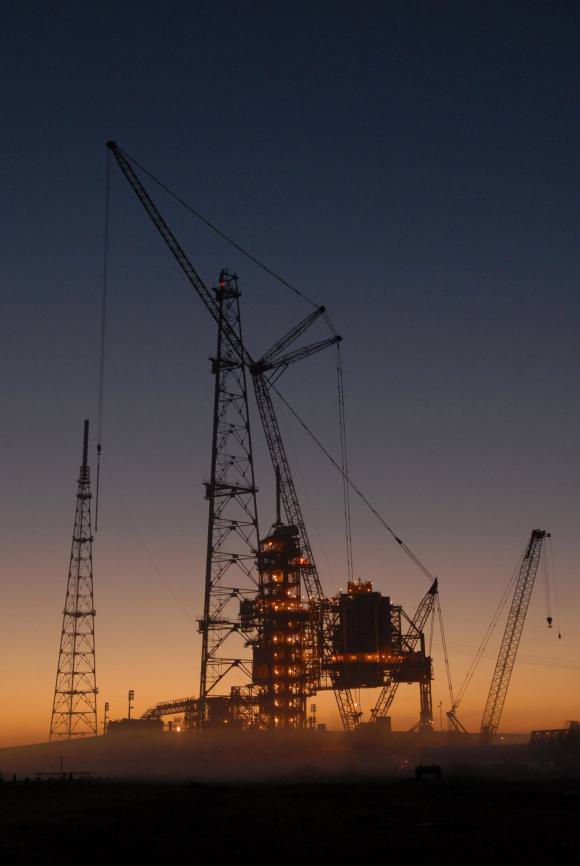
It’s the end of an era, as Launch Pad 39B at Kennedy Space Center has been officially handed over to the Constellation Program. The handover took place Sunday after space shuttle Endeavour was moved to Launch Pad 39A. The ground operations team will finish modifying pad B for in time for first flight test of the Ares I-X rocket, currently scheduled for around August 30 of this year. Modifications will include removing the orbiter access arm and a section of the gaseous oxygen vent arm and installing access platforms and a vehicle stabilization system.
Since the late 1960s, pad B has been instrumental in human spaceflight programs. Originally, the pad was built for the Saturn V rockets for the Apollo flights to the moon, as well as flights to launch the Skylab space station and to send three crews to live on board. It also saw the launch of the Apollo spacecraft that was part of the Apollo Soyuz test program, where spacecraft from the US and USSR docked in space. In the 1980’s the pad was refitted for the space shuttle. Pad 39B was not ready until 1986, and the first Shuttle launch to use it was the ill-fated STS 51-L flight – the Challenger Disaster.
But now it’s time for the next generation of spacecraft and launch system. The Constellation Program is developing the Ares I and Ares V launch vehicles, the Orion crew capsule, and the Altair lunar lander — to carry humans to the International Space Station, the moon and beyond.
[/caption]
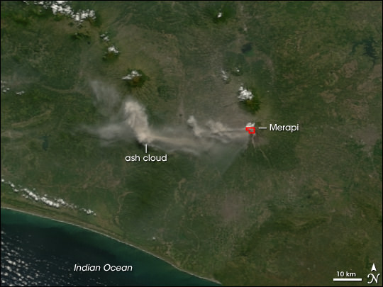
Mount Merapi is an active volcano in Indonesia, on the island of Java near the city of Yogyakarta. The volcano is so active that smoke can be seen coming out of the peak almost every day of the year. Mount Merapi has been erupting regularly since 1548.
Mount Merapi is located in the subduction zone, where the Indo-Australian Plate is going under the Eurasian Plate. Geologists estimate that the volcano started forming 400,000. It was largely built up by basaltic lava flows, but the lava flows have become more viscous in the last 10,000 years or so. With the thicker lava, Merapi has had more explosive eruptions and the formation of lava domes. Merapi has minor eruptions every 2 years or so, and major eruptions every few decades.
Even though it’s an extremely active volcano, thousands of people live on its flanks. Hot gas killed 43 people in 1994, and 13 villages and 1400 people were killed by pyroclastic flows during an eruption in 1930. A series of earthquakes struck Mount Merapi in April/May 2006, the most powerful one on May 27th killed 5,000 people. An eruption on June 14, 2006 spewed out a cloud of volcanic ash that covered a village several kilometers away.
We have written many articles about volcanoes for Universe Today. Here’s an article about Mount Pinatubo, and here’s an article about Mount Tambora.
[/caption]
Mount Tambora is an active stratovolcano on Sumbawa island in Indonesia. It once measured 4,300 meters tall, making it one of the tallest mountains in Indonesia. It’s most famous for an enormous eruption in 1815, when the volcano detonated in the most powerful eruption in recorded history. After 150 cubic kilometers were blasted out of the volcano, and the caldera collapsed, Tambora had dropped down to 2,700 meters.
Tambora had only 3 eruptions over the previous 5,000 years, and none were very severe. But in 1812, Mount Tambora became much more active, culminating in a series of eruptions in April, 1815. On the evening of April 10th, 1815, witnesses saw three huge columns of flame rising up from the volcano. Pumice rocks rained down around the volcano, followed by clouds of ash a few hours later.
Geologists have estimated that Mount Tambora erupted with a force of 7 on the Volcanic Explosivity Index; that’s 4 times more powerful than the 1883 Krakatoa eruption. The ash cloud reached Borneo and Sulawasi islands, located 1,300 kilometers away. Historians argue how many deaths caused by the eruption itself, but estimates range from 10,000 killed by the eruption outright to almost 100,000 when you include the disease and starvation after the eruption.
The effects from the Mount Tambora eruption were felt around the world. It released so much sulphur into the atmosphere that the entire planet was cooled. The following year was known as the year without a summer. Snow fell in Quebec in the middle of summer, and persistent fog obscured much of the Northeastern US. Average annual temperatures dropped by 0.4 to 0.7 degrees C. It created the worst famine in the 19th century.
We have written many articles about volcanoes for Universe Today. Here’s an article about Mount St. Helens, and here’s another about Mount Pinatubo.
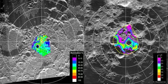
Maps of the lunar poles from the Clementine mission. Credit: NASA
[/caption]
The debate has endured since the early 1960’s: could there be water ice hiding in deep, dark craters near the Moon’s poles, left untouched by sunlight? Several spacecraft orbiting the moon have tried to peer into these craters to find out, but so far no definitive data has been obtained either way. But now NASA and the Indian Space Research Organization (ISRO) are looking to team up two spacecraft to try and answer the question once and for all. “When it happens, it is going to be a unique experiment and will be the first of its kind,” said Dr. Mylswamy Annadurai, project director for the Chandrayaan-I orbiter.
ISRO’s Chandrayaan-I, already in lunar orbit and NASA’s Lunar Reconnaissance Orbiter (LRO), scheduled to launch later this month would be maneuvered to orbit simultaneously over the lunar poles, and the data from the both spacecrafts’ radar instruments would be shared and exchanged. Details of the collaboration are still being worked out, but officials hope to finalize the plans within a month. Artist concept of Chandrayaan-1 orbiting the moon. Credit: ISRO
The master plan for the experiment was developed Paul Spudis of the Lunar and Planetary Institute of Houston, who also led the team of US scientists in the Chandrayaan-I project.
“Our experiment should answer first the broad questions about the existence of lunar polar ice, its extent and purity,” Spudis wrote in his paper published in Lunar and Planetary Science journal.
As the first step, on May 19 ISRO scientists shifted Chandrayaan-I to a new orbit 200 km away, lifting it from the 100 km orbit it had been in previously.
“In contrast to some recent claims, this debate is still open and nothing has occurred in the last few years to cause participants in the debate to abandon their positions,” Spudis wrote in an article for the National Space Society in 2006. “No single piece of evidence for lunar ice is decisive, but I think the preponderance of evidence indicates that water ice exists in permanently dark areas near the poles.”
Finding ice in the moon’s polar region would be significant in many respects. The ice could be an abundant water source for future colonists on the moon, as well as being used for producing propellants. However, Spudis said that although polar ice is important, it is not a requirement to successfully live and work on the Moon.
Additionally, any ice on the moon would hold clues to the evolution of the solar system, as the water was likely the product of comets that crashed onto the moon over a billion years ago.