This Week’s “Where In The World (and What World) Is This?”

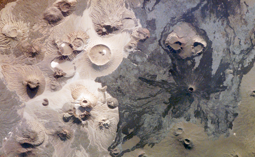
Everyone seemed to enjoy the “Where In The World (and What World) Is This?” post last week, so here’s another one for you. This interesting feature was taken by an orbiting spacecraft on May 31, 2006. This striking circular landform could possibly be an impact crater, or a volcanic rim, or another physical feature that is so large, it can only be seen as a whole from the lofty vantage point that a spacecraft in orbit provides. Is this feature on Earth, or is it located on one of the other 176 worlds in our solar system (that’s 7 other planets and 169 known moons)? And what spacecraft is responsible for this image?

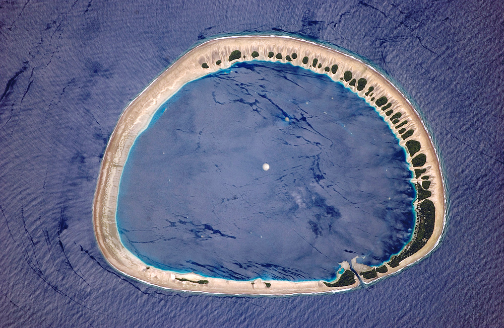
Since it’s so close to Earth Day, I had to choose an image from Earth. But what in the world is this a picture of? This is Nukuoro Atoll, a circular island of coral that completely encircles a lagoon. Nukuoro Atoll is part of the Caroline Islands, which stretch northeast of Papua New Guinea in the western Pacific. It is one of 607 islands that make up the Federated States of Micronesia. It is located just north of the equator (3.85° North, 154.9° East). This image reinforces that we live on a wonderfully diverse and endlessly fascinating planet.

Nukuoro Atoll is almost a little world by itself. About 900 people live on Nukuoro, but is very remote. It has no airstrip, and a passenger boat comes to visit irregularly only once a month. The tiny population speaks its own unique language.

The lagoon is 6 kilometers (about 3.7 miles) in diameter. Fishing, animal husbandry, and agriculture are the main occupations. The atoll is mostly sandy, but the dark areas are green vegetation.

In the close-up image, structures are visible. The white dots found in the lagoon are coral heads. The most prominent one is almost directly in the middle of the lagoon.

The picture was taken by astronauts on board the International Space Station as part of the ISS Crew Earth Observations experiment. They used a Kodak 760C digital camera with an 800 mm lens.

Original News Source: Gateway to Astronaut Photography of Earth

Where In The World (and What World) Is This?

Anyone care to guess what orbiting spacecraft is responsible for taking this image, or even what world this is a picture of? At first glance, with all those craters, it could be Mars. However, the coloring isn’t quite right for the Red Planet. Is it a photograph of Mercury or an image of the moon?

OK, yes, this is an image of Earth, but you were wondering there for awhile, weren’t you! Interestingly enough, the white area is not snow, and the craters are not impact craters, but volcanic. And what spacecraft gets credit for the image? The International Space Station. This is one of the most recent images taken by the astronauts on board the ISS as part of the Earth Observatory program. A wonderful website, NASA’s Gateway to Astronaut Photography of Earth, hosts an incredible collection of photographs that astronauts have taken of our home planet.

Beginning with the Mercury missions in the early 1960s, astronauts have taken photographs of the Earth. As of April 7, 2008, this website has 759,527 views of the Earth, which includes 315,923 from the ISS. The site processes images coming down from the International Space Station on a daily basis, so the database is continually growing. The U.S. Destiny Laboratory module has a science window with high optical quality, which usually faces the Earth, and most of the ISS’s images are taken from that window on the world. On board the ISS is a nice selection of professional digital cameras, and a variety of lenses. One could spend hours (or days or a lifetime!) browsing through the striking photographs of Earth the astronauts have taken. The website also includes lots of information about each of the images, and a fun Where In the World quiz to test your geographical knowledge.

The image above is of the Harrat Khaybar volcanic field, a 14,000-square-kilometer area located in the western Arabian peninsula. The volcanic field was formed by eruptions along a 100-kilometer, north-south vent system over the past 5 million years. The most recent recorded eruption took place between 600-700 AD.

Harrat Khaybar contains a wide range of volcanic rock types and spectacular landforms, several of which are represented in this astronaut photograph. There are dark, fluid basalt lava flows, and the white deposits are sand and silt that accumulate in the depressions. There are lava domes and cones from the past volcanic activity.

The ISS astronauts take images daily of our planet. The image of Harrat Khaybar was taken on March 31, 2008, with a Kodak 760C digital camera fitted with a 400 mm lens, and is provided as part of the the ISS Crew Earth Observations experiment.

Original News Source: Earth Observatory website