Earth and Moon imaged from Cassini on July 19, 2013
Did you smile and wave at Saturn on Friday? If you did (and even if you didn’t) here’s how you — and everyone else on Earth — looked to the Cassini spacecraft, 898.4 million miles away.
Hope you didn’t blink!
The image above is a color-composite made from raw images acquired by Cassini in red, green, and blue visible light wavelengths. Some of the specks around the edges are background stars, and others are the result of high-energy particle noise, of which some have been digitally removed.
The Moon is the bright dot just below and to the left of Earth. (An original raw image can be seen here.)
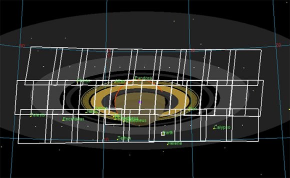
Cassini acquired the images while capturing views of Saturn in eclipse against the Sun between 22:24:00 UTC on July 19 and 02:43:00 UTC on July 20 (6:24 to 10:43 pm EDT July 19.) On Cassini time, the Earth imaging took place between 22:47:13 UTC (6:47:13 pm EDT) and 23:01:56 UTC (7:01:56 pm EDT) on the 19th.
Full mosaic arrangement acquired by Cassini on July 19-20 UTC. Earth was positioned just below the planet. (NASA/JPL-Caltech/SSI)
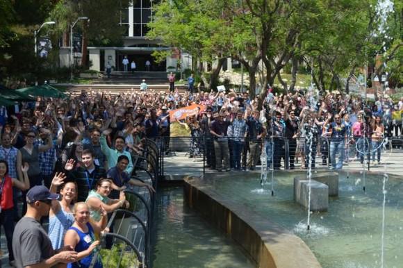
The world was invited to “Wave at Saturn” beginning 5:27 pm EDT on Friday — which allowed enough time for the photons from a waving world to actually reach Cassini’s camera just beyond Saturn, 1.44 billion kilometers away. (Did you wave? I did!) It was the first time Earth’s population was made aware beforehand that their picture would be taken from such a cosmic distance.
A crowd gathered on the mall at NASA’s Jet Propulsion Laboratory in Pasadena to wave at Saturn on July 19 (NASA/JPL-Caltech)
The image of our planet and moon, seen as merely a couple of bright points of light against the blackness of space, recalls Sagan’s poignant “pale blue dot” passage from Cosmos…
“From this distant vantage point, the Earth might not seem of any particular interest. But for us, it’s different. Consider again that dot. That’s here, that’s home, that’s us. On it everyone you love, everyone you know, everyone you ever heard of, every human being who ever was, lived out their lives. The aggregate of our joy and suffering, thousands of confident religions, ideologies, and economic doctrines, every hunter and forager, every hero and coward, every creator and destroyer of civilization, every king and peasant, every young couple in love, every mother and father, hopeful child, inventor and explorer, every teacher of morals, every corrupt politician, every “superstar,” every “supreme leader,” every saint and sinner in the history of our species lived there – on a mote of dust suspended in a sunbeam.
The “pale blue dot” of Earth captured by Voyager 1 in Feb. 1990 (NASA/JPL)
The Earth is a very small stage in a vast cosmic arena. Think of the rivers of blood spilled by all those generals and emperors so that, in glory and triumph, they could become the momentary masters of a fraction of a dot. Think of the endless cruelties visited by the inhabitants of one corner of this pixel on the scarcely distinguishable inhabitants of some other corner, how frequent their misunderstandings, how eager they are to kill one another, how fervent their hatreds.
Our posturings, our imagined self-importance, the delusion that we have some privileged position in the universe, are challenged by this point of pale light. Our planet is a lonely speck in the great enveloping cosmic dark. In our obscurity, in all this vastness, there is no hint that help will come from elsewhere to save us from ourselves.
The Earth is the only world known so far to harbor life. There is nowhere else, at least in the near future, to which our species could migrate. Visit, yes. Settle, not yet. Like it or not, for the moment the Earth is where we make our stand.
It has been said that astronomy is a humbling and character-building experience. There is perhaps no better demonstration of the folly of human conceits than this distant image of our tiny world. To me, it underscores our responsibility to deal more kindly with one another, and to preserve and cherish the pale blue dot, the only home we’ve ever known.”
— Carl Sagan (1934–1996)
A full mosaic of Cassini’s imaging of Saturn silhouetted against the Sun is expected in the coming weeks.
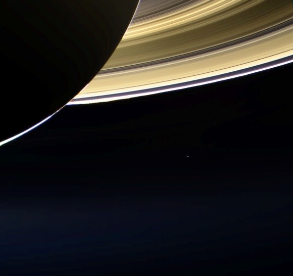
UPDATE: Here’s another RGB color composite, made from raw images acquired with Cassini’s wide-angle camera. It shows a view of Saturn and the rings in eclipse as seen from below and behind, backlit by the Sun. Earth is the bright point light near the center. (See original here.)
Raw image (RGB composite) of Saturn in eclipse with Earth in the distance — just a pale blue dot. (NASA/JPL-Caltech/SSI. Composite by J. Major.)
Images: NASA/JPL-Caltech/Space Science Institute. Composites by Jason Major.
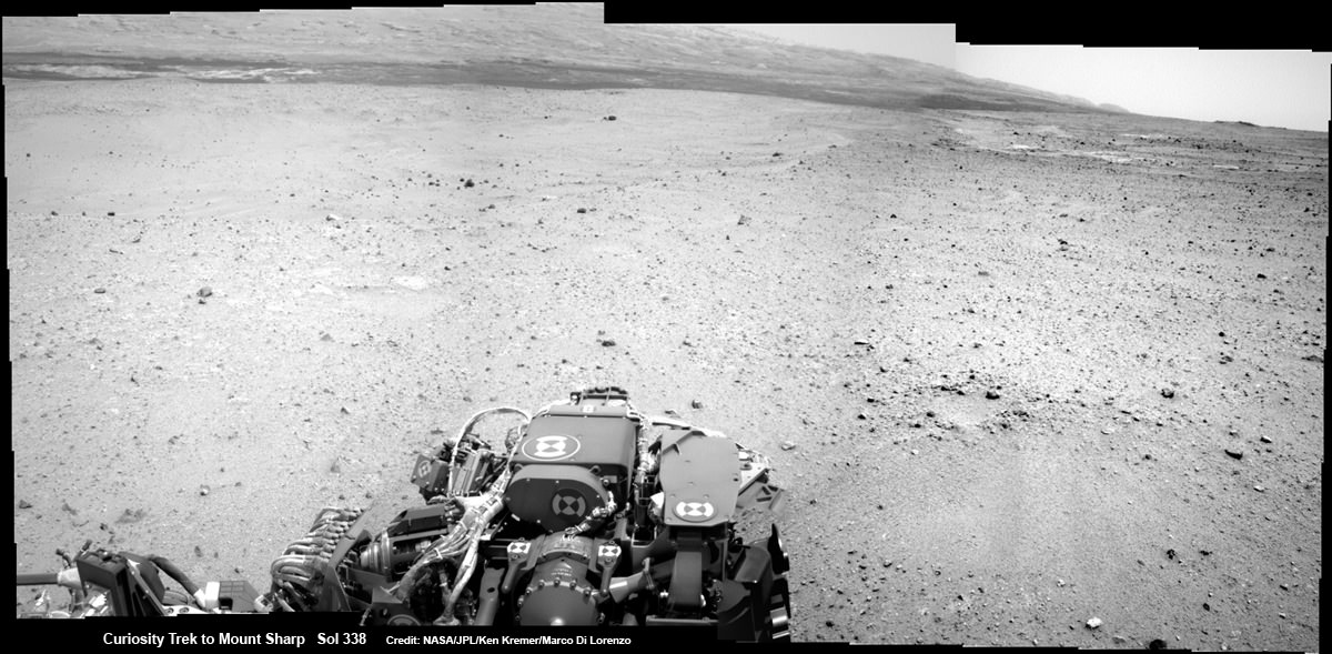
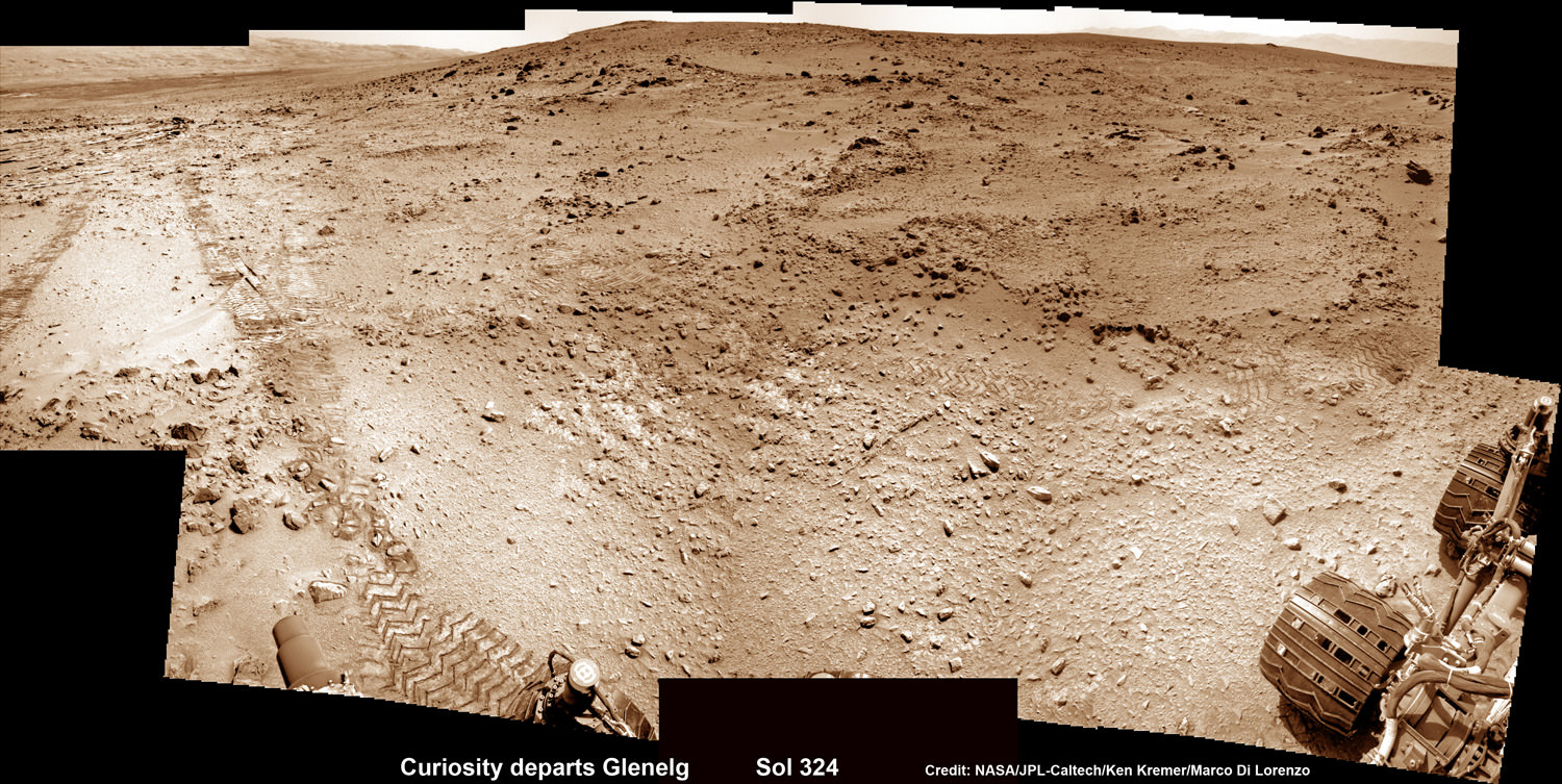
Curiosity On the Road to Mount Sharp and treacherous Sand Dunes - Sol 338 - July 19. Curiosity captured this panoramic view of the path ahead to the base of Mount Sharp and potentially dangerous sand dunes after her most recent drive on July 19, 2013. She must safely cross over the dark dune field to climb and reach the lower sedimentary layers of Mount Sharp. Credit: NASA/JPL-Caltech/Ken Kremer-(kenkremer.com)/Marco Di Lorenzo
Curiosity On the Road to Mount Sharp and treacherous Sand Dunes – Sol 338 – July 19
Curiosity captured this panoramic view of the path ahead to the base of Mount Sharp and potentially dangerous sand dunes after her most recent drive on July 19, 2013. She must safely cross over the dark dune field to climb and reach the lower sedimentary layers of Mount Sharp. Stowed robotic arm on rover deck seen at center.
See JPL traverse map below pinpointing the view from this location
Credit: NASA/JPL-Caltech/Ken Kremer-(kenkremer.com)/Marco Di Lorenzo[/caption]
NASA’s state-of-the-art Curiosity Mars rover is stepping up the driving pace and rolling relentlessly across alien Martian terrain towards the towering mystery mountain known as Mount Sharp that’s holds the keys to the Red Planets past evolution and whether its an abode for Life.
To uncover the latest scoop on the robots otherworldly adventures, Universe Today conducted an exclusive interview with the Curiosity Project Manager Jim Erickson, of NASA’s Jet Propulsion Laboratory (JPL).
In Part 2 of my conversation with Jim Erickson we’ll discuss more about the rover’s traverse across alien territory that’s simultaneously a science gold mine and a potential death trap, as well as Comet ISON and nighttime observations and science planning.
“When Comet ISON is in the sky I’m sure we’ll do some observations of it depending on when its visible,” Erickson told me.
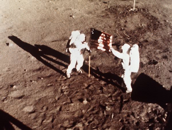
Today, July 20, is Sol 339 of the rovers mission to Mars. And also the 44th anniversary of the 1st human Moonwalks in 1969.
And Curiosity just drove another 34 meters yesterday, Sol 338 (July 19) – for a total distance exceeding 1.1 kilometers.
Curiosity’s Traverse Map Through Sol 338
This map shows the route driven by NASA’s Mars rover Curiosity through Sol 338 of the rover’s mission on Mars (July 19, 2013). Numbering of the dots along the line indicate the sol number of each drive. North is up. The scale bar is 200 meters (656 feet). From Sol 337 to Sol 338, Curiosity had driven a straight line distance of about 122.90 feet (32.59 meters). The base image from the map is from the High Resolution Imaging Science Experiment Camera (HiRISE) in NASA’s Mars Reconnaissance Orbiter. Image Credit: NASA/JPL-Caltech/Univ. of Arizona
As for Martian sand dunes, they dunes offer both exciting opportunities and lurking dangers to the rovers well being.
Indeed fields of Martian sand dunes are potential death traps and the six wheeled rover has no choice but to traverse across an extensive dune field as she closes in on the base of Mount Sharp
Recall that NASA’s now long lived Opportunity rover nearly perished rather early in her mission at the ‘Purgatory’ dune field on Meridiani Planum.
Spirit died after more than six highly productive years on the Red Planet when she was unable to escape a hidden sand trap she had accidentally fallen wheels deep into as the vehicle was merrily roving beside an eroded volcano at Gusev Crater on the approach to the mysterious Von Braun mound.
So, dunes are serious business
Here is Part 2 of my interview with Jim Erickson.
Ken Kremer: Which direction is Curiosity headed? Will she be following the southwest route shown in the ellipse on the JPL map – see traverse map below – or reinvestigate any other spots nearer the landing site first?
Jim Erickson: We have a good general idea. We will be on a general heading of southwest, not west which would have taken us back near the landing site [at Bradbury Landing].
Curiosity Route Map From ‘Glenelg’ to Mount Sharp
This map shows where NASA’s Mars rover Curiosity landed in August 2012 at “Bradbury Landing”; the area where the rover worked from November 2012 through May 2013 at and near the “John Klein” target rock in the “Glenelg” area; and the mission’s next major destination, the entry point to the base of Mount Sharp. Credit: NASA/JPL-Caltech/Univ. of Arizona
Ken: So the rover will not pass by the Hottah outcrop of concretions formed in water and investigated early in the mission?
Jim Erickson: No. The intent for the ellipse [shown on the map] is that we will be traveling in it to get to an area where the sand dunes look better for crossing [to the base of Mount Sharp]. When we get there we will know reality. And we will pick a safe spot to cross.
The dunes can be both an issue or in some cases easy sailing.
My experience on MER [Spirit & Opportunity] was that when you are going with the dunes, down a trough, they tend to be well packed and that was great driving.
But if you need to make a right turn, that can be a challenge for a couple of reasons. It is harder to see what is inside the next trough. And you have to drive to the top of the dune. So your driving is limited until you can see what’s inside the next dune.
Level ground is more straightforward. You know exactly what to look for if the terrain doesn’t change the next day. So you can do the same thing you did last night based on the new set of images.
If the terrain is changing then it gets more complicated.
Ken: Will you be straddling the dunes or driving alongside some safe distance away?
Jim Erickson: We have been going through various options of different planned routes. At some point we have to go with the dune directions.
So we’ll be traveling down some troughs later on. We will definitely have to pick our way through them.
Part of it is gaining experience in this new area of Mars with how the sand dunes and troughs themselves actually are.
So we’ll have to wait and see. We know we’ll have to deal with the dunes. Depending on how these dunes act we may have to do different things compared to MER.
Ken: What’s the health status of Curiosity?
Jim Erickson: We’re doing great. There are always active things we are looking at.
We had the anomaly before conjunction and have put in place a number of software mitigations and reconfigured the A side memory so that we can work around the hardware problem that happened. If we have another problem, both the A and B side memory can handle it gracefully, unlike the last time.
Ken: Describe the rover’s power situation? And the ability to do nighttime observations like the recent imagery of Phobos rising?
And certainly will be able to do nighttime observations.
Ken: What’s the plan for observations of Comet ISON?
Jim Erickson: When we get to the point when Comet ISON is in the sky I’m sure we’ll do some observations of it, depending on the time period when its visible.
Note: NASA’s Curiosity and Opportunity rovers will have a view of ISON in October with Oct. 1, 2013, being the comet’s closest approach to Mars.
NASA’s Directory of Planetary Science Jim Green told me previously that NASA is very interested in using its orbiting and surface assets at Mars to study Comet ISON. It’s a once in a lifetime opportunity.
Early October 2013 will be the prime viewing time for ISON from the vicinity of the Red Planet.
Let’s hope that NASA’s quartet of spacecraft and ESA’s lone orbiter capture some breathtaking imagery and science observations.
Ken: About the recent Phobos nighttime images, a Universe Today reader asked whether the other points of light beside Phobos were stars or hot pixels?
Jim Erickson: The specks are hot pixels [not stars], intensified by the long exposure times for the image.
Video Caption: ‘Phobos Rising’ – This movie clip shows Phobos, the larger of the two moons of Mars, passing overhead, as observed by Curiosity in a series of images centered straight overhead starting shortly after sunset on June 28, 2013. Phobos first appears near the lower center of the view and moves toward the top of the view. The apparent ring is an imaging artifact. The other bright spots are hot pixels – not stars. Credit: NASA/JPL-Caltech
Ken: How about the prospects for science along the way to the mountain?
Jim Erickson: We expect to do science along the way to Mount Sharp, for example in terms of atmospheric measurements.
We will stop at some preplanned sites. Exactly which ones is still being debated by the scientists.
And we’ll do the right thing – If we see something spectacular along the way. Just because we may not have identified it previously, that doesn’t mean we won’t stop and examine it.
Things are going very well, says Erickson.
Erickson has worked in key positions on many NASA planetary science missions dating back to Viking in the 1970’s. These include the Galileo mission to Jupiter, both MER rovers Spirit & Opportunity, as well as a stint with the Mars Reconnaissance Orbiter (MRO).
I’ll have more upcoming from Jim about Curiosity’s Martian drilling activities.
As of today (July 20) Curiosity has driven nine times since leaving the Glenelg/Yellowknife Bay area on July 4 (Sol 324), totaling nearly 300 meters.
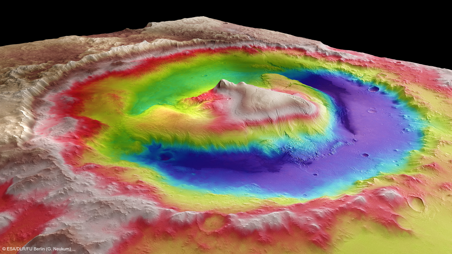
This photomosic shows NASA’s Curiosity departing at last for Mount Sharp- her main science destination. Note the wheel tracks on the Red Planet’s surface. The navcam camera images were taken on July 4, 2013 (Sol 324). Credit: NASA/JPL-Caltech/Ken Kremer (kenkremer.com)/Marco Di LorenzoMount Sharp inside Gale Crater – is the primary destination of NASA’s Curiosity rover mission to Mars. Curiosity landed on the right side of the mountain as shown here, near the dune field colored dark blue. Mount Sharp dominates Gale Crater. It is 3.4 mile (5.5 km) high. Gale Crater is 154 km wide. This image was taken by the High Resolution Stereo Camera (HRSC) of ESA’s Mars Express orbiter. Credit: ESA/DLR/FU Berlin (G. Neukum)
Saturn V Moon Rocket F-1 Engine Thrust Chamber recovered from the floor of the Atlantic Ocean. Credit: Jeff Bezos Expeditions
In a fitting testament to NASA’s momentous Apollo Moon Landing Program, NASA and billionaire Jeff Bezos confirmed today (July 19) the discovery of a powerful F-1 first stage engine component from the Saturn V moon rocket that launched three American astronauts on the historic journey of Apollo 11 to land the first two humans on the Moon on July 20, 1969.
“On the eve of the 44th moonwalk anniversary, the Bezos Expedition confirms an Apollo 11 Saturn V F1 engine find,” NASA officially announced on its websites just moments ago today, July 19.
Apollo 11 commander and NASA astronaut Neil Armstrong, was immortalized forever when he first set foot on the moon 44 years ago tomorrow (July 20, 1969), followed minutes later by the lunar module pilot, NASA astronaut Buzz Aldrin.
The Saturn V rockets first stage was powered by a cluster of five F-1 engines – a technological marvel and the most powerful single-nozzle, liquid-fueled rocket engine ever developed.
“44 years ago tomorrow Neil Armstrong stepped onto the moon, and now we have recovered a critical technological marvel that made it all possible,” says Bezos on his Expedition website today.
Apollo 11 Saturn V F-1 Engine Thrust Chamber recovered from the floor of the Atlantic Ocean- stenciled with Rocketdyne serial number “2044”. Credit: Jeff Bezos Expeditions
Bezos, founder and Chief Executive Officer of the aerospace company Blue Origin and Amazon.com, originally announced the discovery and recovery of significant components of two flown F-1 engines amongst a field of twisted wreckage from the floor of the Atlantic Ocean in March of this year, aboard the Seabed Worker at Port Canaveral, Florida, along with a treasure trove of other major Saturn V components hauled up from a depth of almost 3 miles.
“We brought back thrust chambers, gas generators, injectors, heat exchangers, turbines, fuel manifolds and dozens of other artifacts – all simply gorgeous and a striking testament to the Apollo program,” wrote Bezos in a update this morning, July 19.
But until today, the engines exact identification remained elusive because of decades of severe seabed corrosion and their fiery, destructive end upon plunging and smashing unimpeded onto the ocean’s surface.
Saturn V F-1 Engine nozzle recovered from the floor of the Atlantic Ocean. Credit: Jeff Bezos Expeditions
Conservators from the Kansas Cosmosphere and Space Center in Hutchinson, Kansas worked painstakingly since March to identify the F-1 engine parts.
“Today, I’m thrilled to share some exciting news. One of the conservators who was scanning the objects with a black light and a special lens filter has made a breakthrough discovery – “2044” – stenciled in black paint on the side of one of the massive thrust chambers, says Bezos.
“2044 is the Rocketdyne serial number that correlates to NASA number 6044, which is the serial number for F-1 Engine #5 from Apollo 11. The intrepid conservator kept digging for more evidence, and after removing more corrosion at the base of the same thrust chamber, he found it – “Unit No 2044” – stamped into the metal surface.”
Blacklight view of Apollo 11 Saturn V F-1 Engine recovered from the floor of the Atlantic Ocean with identifying “2044” serial number. Credit: Jeff Bezos Expeditions
Apollo 11 launched to the Moon on July 16, 1969 from Launch Complex 39-A at the Kennedy Space Center in Florida.
Armstrong and Aldrin landed on the Sea of Tranquility inside the Lunar Module. They took a single lunar excursion and spent 2 hours and 11 minutes as the first two men to walk on the moon. They stayed on the moon for a total of 21 hours and 36 minutes before blasting off for the journey back home to Earth.
Armstrong suddenly passed away nearly a year ago on August 25, 2012 at age 82 – read my stories, here and here.
Aldrin is still active and strenuously advocating for starting human expeditions to the Red Planet.
He outlined his exploration concepts in a newly published book titled – “Mission to Mars.”
The five F-1 engines used in the 138-foot-tall Saturn V first stage known as the S-IC generated 7.5 million pounds of liftoff thrust, or some 1.5 million pounds each. They stand 19 feet tall by 12 feet wide. Each one weighs over 18,000 pounds and was manufactured by Rocketdyne.
The F-1 had more power than all three space shuttle main engines combined. They burned a mixture of liquid oxygen and kerosene fuel for two-and-one-half-minutes, carrying the Saturn V to an altitude of some 36 miles.
Altogether, six Apollo Moon landing flights boosted by Saturn V’s sent a total of 12 humans on moon walking expeditions to Earth’s nearest neighbor during the 1960s and 1970s.
“This is a big milestone for the project and the whole team couldn’t be more excited to share it with you all,” Bezos wrote.
Bezos’ Blue Origin firm is also working to develop a commercial rocket and ‘space taxi’ to finally resume launching American astronauts back to low Earth orbit from American soil after a multi year gap.
More than four decades have passed since the last humans traversed the lunar surface in December 1972 during NASA’s Apollo 17 moon landing mission.
After all that time, the F-1 may yet live again.
NASA is now working on an upgraded F-1 to power a future variant of the new SLS heavy lift booster under development and intended to launch humans aboard the new Orion crew capsule back to the Moon and to deep space destinations including Asteroids and Mars.
Neil Armstrong and Buzz Aldrin plant the US flag on the Lunar Surface during 1st human moonwalk in history – exactly 44 years ago on July 20, 1969 during Apollo 1l mission. Credit: NASA
Just one of the many images from Cassini used to make up "Around Saturn"
In honor of this today’s Wave at Saturn and The Day the Earth Smiled events, celebrating images to be taken of Earth from Saturn, here’s a wonderful movie showing highlights from Cassini’s exploration of the giant planet, its magnificent rings, and fascinating family of moons.
Assembled by Fabio Di Donato in memory of astrophysicist, author and activist Margherita Hack, who passed away June 29 at the age of 91, this video is an impressive tour of the Saturnian system — and a truly stunning tribute as well.
“She made me love the stars,” Fabio wrote.
This video shows a selection from more than 200,000 pictures taken by the Cassini spacecraft around Saturn’s rings in a period between 2005 and 2013. RAW images were processed to PNG thanks to the Vicar-to-PNG procedure provided by Jessica McKellar.
The music is Jazz Suite No.2: VI Waltz 2 by Shostakovich, performed by the Armonie Symphony Orchestra.
As always, you can see the latest images and news from the Cassini mission here, and find out how your photo is going to be taken from 900 million miles away (and also 60 million miles away from Mercury!) here.
Video: Fabio Di Donato. Original images: NASA/JPL-Caltech/SSI.
P.S.: Want to get a personalized certificate saying you “Waved at Saturn?” Click here.
Mount Sharp inside Gale Crater - is the primary destination of NASA’s Curiosity rover mission to Mars. Curiosity landed on the right side of the mountain as shown here, near the dune field colored dark blue. Mount Sharp dominates Gale Crater. It is 3.4 mile (5.5 km) high. Gale Crater is 154 km wide. This image was taken by the High Resolution Stereo Camera (HRSC) of ESA’s Mars Express orbiter. Credit: ESA/DLR/FU Berlin (G. Neukum)
As NASA’s 1 ton Curiosity Mars rover sets out on her epic trek to the ancient sedimentary layers at the foothills of mysterious Mount Sharp, Universe Today conducted an exclusive interview with the Curiosity Project Manager Jim Erickson, of NASA’s Jet Propulsion Laboratory (JPL) to get the latest scoop so to speak on the robots otherworldly adventures.
The science and engineering teams are diligently working right now to hasten the rovers roughly year long journey to the 3.4 mile (5.5 km) high Martian mountain – which is the mission’s chief destination and holds caches of minerals that are key to sparking and sustaining life.
“We have departed Glenelg and the Shaler outcrop and started to Mount Sharp,” Erickson told me.
Mount Sharp lies about 5 miles (8 kilometers) distant – as the Martian crow flies.
Curiosity Sets Sail for Mount Sharp
This photomosic shows NASA’s Curiosity departing at last for Mount Sharp- her main science destination. Note the wheel tracks on the Red Planet’s surface. The navcam camera images were taken on July 4, 2013 (Sol 324). Credit: NASA/JPL-Caltech/Ken Kremer (kenkremer.com)/Marco Di Lorenzo
Curiosity will have to traverse across potentially treacherous dune fields on the long road ahead to the layered mountain.
“Things are going very well and we have a couple of drives under our belt,” said Erickson.
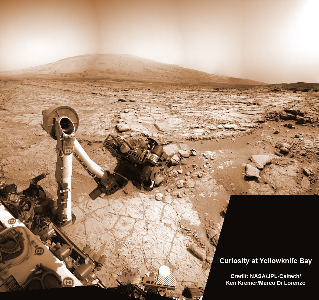
Curiosity just completed more than half a year’s worth of bountiful science at Glenelg and Yellowknife Bay where she discovered a habitable environment on the Red Planet with the chemical ingredients that could sustain Martian microbes- thereby already accomplishing the primary goal of NASA’s flagship mission to Mars.
Curiosity’s handlers are upgrading the rovers ‘brain’ with new driving software, making her smarter, more productive and capable than ever before, and also far more independent since her breathtaking touchdown inside Gale Crater nearly a year ago on Aug. 6, 2012.
“We continue to drive regularly. The next drive is planned tomorrow and will be executed the following day.”
As of today (Sol 336, July 17), Curiosity has driven six times since leaving Glenelg on July 4 (Sol 324), totaling more than 180 meters.
Curiosity’s Traverse Map Through Sol 333
This map shows the route driven by NASA’s Mars rover Curiosity through Sol 333 of the rover’s mission on Mars (July 14, 2013). Numbering of the dots along the line indicate the sol number of each drive. North is up. The scale bar is 200 meters (656 feet). From Sol 331 to Sol 333, Curiosity had driven a straight line distance of about 45.05 feet (13.73 meters). The base image from the map is from the High Resolution Imaging Science Experiment Camera (HiRISE) in NASA’s Mars Reconnaissance Orbiter. Credit: NASA/JPL-Caltech/Univ. of Arizona
Scientists specifically targeted Curiosity to Gale Crater and Mount Sharp because it is loaded with deposits of clay minerals that form in neutral water and that could possibly support the origin and evolution of simple Martian life forms, past or present.
Erickson has worked in key positions on many NASA planetary science missions dating back to Viking. These include the Galileo mission to Jupiter, both MER rovers Spirit & Opportunity, as well as a stint with the Mars Reconnaissance Orbiter (MRO).
Here is Part 1 of my wide ranging conversation with Jim Erickson, Curiosity Project Manager of JPL. Part 2 will follow.
I asked Erickson to describe the new driving software called autonomous navigation, or autonav, and how it will help speed Curiosity on her way. Until now, engineers on Earth did most of the planning for her.
Jim Erickson: We have put some new software – called autonav, or autonomous navigation – on the vehicle right after the conjunction period back in March 2013. This will increase our ability to drive.
The reason we put it on-board is that we knew it would be helpful when we started the long drive to Mount Sharp. And we are itching to check that out. Over the next few weeks we will be doing various tests with the autonav.
Ken Kremer: How will autonav help Curiosity?
Jim Erickson: The rover will have the ability to understand how far it’s driving, whether its slipping or not, and to improve safety.
And then the next step will be in effect to allow the rover to drive on its own.
Ken: How often will Curiosity drive?
Jim Erickson: Somewhere like every other day or so. We plan a drive, see how it goes and whether it went well and then we move further to the next drive. We are implementing that as it stands while we do the checkouts of autonav.
We might have to stop driving for part of the autonav checkout to complete the testing.
Basically we are limited mainly by the amount of days that we have successful completion of the previous day’s drive. And whether we have the information come back down [to Earth] so that we can plan the next day’s drive.
In some circumstances Mars time can rotate so that we don’t get the data back in time, so therefore we won’t be driving that day.
Ken: Can you ever drive two days in a row?
Jim Erickson: Yes we can, if the timing is right. If we get the results of the day’s drive (n) in time before we have to plan the next day’s drive (n+1) – almost as if you’re on Mars time. Then that would work fine.
Also, when we get the autonav capability we can plan two days in row. One day of directed driving and the second day can be ‘OK here’s your target from wherever you end up, try and go to this spot’.
This will increase the productivity!
Ken: When will autonav be up and running?
Jim Erickson: Something like two to three weeks. We need to thoroughly look at all the tests and validate them first so that we’re all comfortable with autonav.
Ken: What’s the Martian terrain on the floor of Gale crater like right now and for the next few miles?
Jim Erickson: It’s a mix of sand and different flagstone areas. As we get into it we’ll need to be able to drive comfortably on both. There aren’t too many large rocks that would be a problem right now. There is some shelf area that we’ll be going around.
Right now the area we’re in is actually a good thing to give us practice identifying obstacles and getting around them. This will help us later on when we see obstacles and want to be driving quicker.
Ken: What’s the overall plan now, a focus on driving or stopping and investigating?
Jim Erickson: – It’s not the intent to be stopping. This will be a good couple of weeks driving.
In Part 2 of my conversation with Jim Erickson we’ll discuss more about the rover’s traverse across alien territory that’s simultaneously a science gold mine and a potential death trap, as well as drilling and sampling activities, Comet ISON observations and upcoming science objectives.
Previous experience with rovers on Mars will be enormously helpful in studying how the rover interacts with dune fields. Autonav was first employed on the MER rovers.
The rover drivers and science team gained lots of experience and know how while driving both Spirit & Opportunity through numerous gigantic fields of dunes of highly varying composition and complexity.
NASA’s Curiosity rover reaches out in ‘handshake’ like gesture with dramatic scenery of Mount Sharp in the background. This mosaic of images was snapped by Curiosity on Sol 262 (May 2, 2013) and shows her flexing the robotic arm. Two drill holes are visible on the surface bedrock below the robotic arm’s turret. Credit: NASA/JPL-Caltech/Ken Kremer-(kenkremer.com)/Marco Di LorenzoCuriosity Route Map From ‘Glenelg’ to Mount Sharp
This map shows where NASA’s Mars rover Curiosity landed in August 2012 at “Bradbury Landing”; the area where the rover worked from November 2012 through May 2013 at and near the “John Klein” target rock in the “Glenelg” area; and the mission’s next major destination, the entry point to the base of Mount Sharp. Credit: NASA/JPL-Caltech/Univ. of Arizona
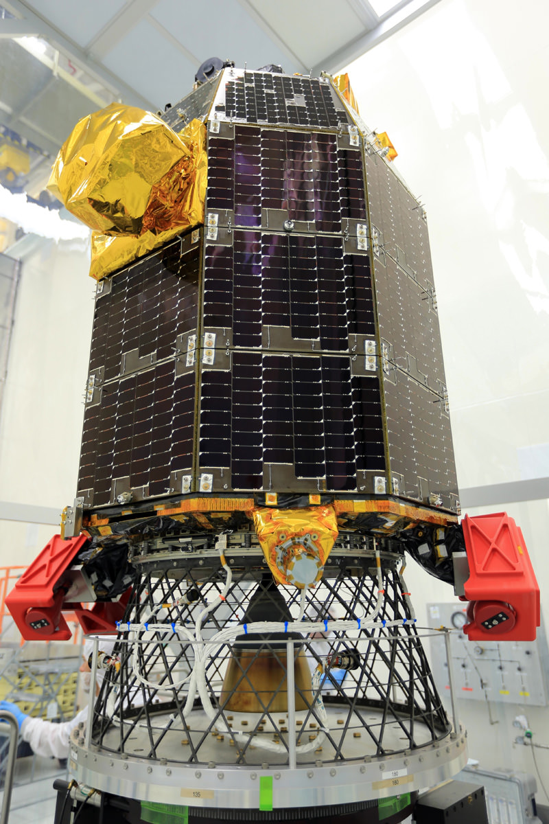
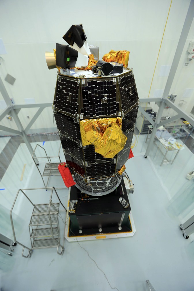
The LADEE spacecraft awaits spin balance testing, conducted to ensure stability during flight, at NASA’s Wallops Flight Facility in Virginia. LADEE is slated to liftoff from Wallops on Sep. 5, 2013 July 10. Credit: NASA/Patrick Black
NASA’s Lunar Atmosphere and Dust Environment Explorer (LADEE) Observatory has arrived at the launch site on the Eastern Shore of Virginia at NASA’s Wallops Flight Facility on Wallops Island and is now in the midst of weeks of performance testing to ensure it is ready for liftoff in early September.
The LADEE lunar orbiting probe will be the first planetary science mission ever launched from NASAWallops and the Mid-Atlantic Regional Spaceport (MARS). It will soar to space atop a solid fueled Minotaur V rocket on its maiden flight.
LADEE will blaze a brilliant trail to the Moon during a spectacular nighttime blastoff slated for Sept. 6, 2013 at 11:27 PM from Launch Pad 0B.
LADEE is equipped with three science instruments to gather detailed information about the lunar atmosphere, conditions near the surface and environmental influences on lunar dust.
“LADEE will investigate the moons tenuous exosphere, trace outgases like the sodium halo and lofted dust at the terminator,” said Jim Green, Planetary Science Division Director at NASA HQ, in an exclusive interview with Universe Today.
“The spacecraft has a mass spectrometer to identify the gases, a physical dust detector and an imager to look at scattered light from the dust. These processes also occur at asteroids.”
“And it will also test a laser communications system that is a technology demonstrator for future planetary science missions. It communicates at 650 megabits per second,” Green explained to me.
The couch sized 844 pound (383 kg) robotic explorer was assembled at NASA’s Ames Research Center, Moffett Field Calif., and is a cooperative project with NASA Goddard Spaceflight Center in Maryland.
The LADEE spacecraft awaits spin balance testing, conducted to ensure stability during flight, at NASA’s Wallops Flight Facility in Virginia. LADEE is slated to liftoff from Wallops on Sept. 6, 2013. Credit: NASA/Patrick Black
The spacecraft was then shipped cross country by a dedicated truck inside a specially-designed shipping container – blanketed with protective nitrogen – which insulated the spacecraft from temperature, moisture, bumps in the road and more than a few crazy drivers.
The first leg of LADEE’s trip to the Moon took 5 days. The trans lunar leg will take 30 days.
It’s standard practice that whenever space probes are moved by ground transportation that they are accompanied by a caravan that includes a lead scout vehicle to ensure safe road conditions and followed by engineers monitoring the health and environmental storage conditions.
Technicians are now engaged in a lengthy series of performance tests to confirm that LADEE was not damaged during the road trip and that all spacecraft systems are functioning properly.
“One important preparation about to begin is spin-balancing LADEE,” says Butler Hine, LADEE Project Manager. “During this procedure, the spacecraft is mounted to a spin table and rotated at a high-speed to make sure it is perfectly balanced for launch.”
After all spacecraft systems pass the performance tests, LADEE will be fueled, encapsulated and moved to the Wallops Island launch pad later this summer for mating with the five stage Minotaur V booster stack.
“I’m excited about the night launch because people up and down the Atlantic seacoast will be able to see it,” Green told me.
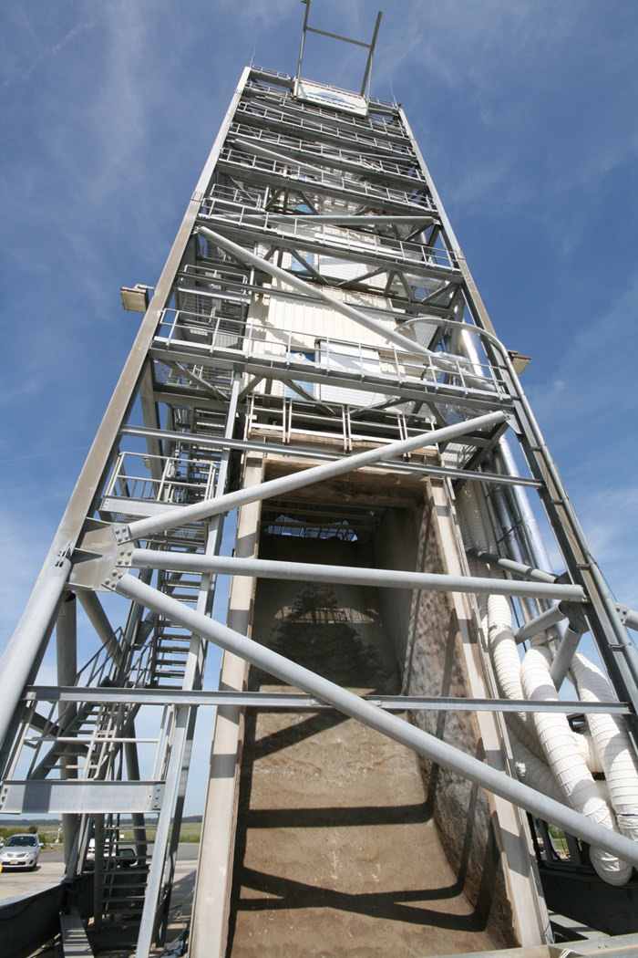
Looking up the Flame Trench –
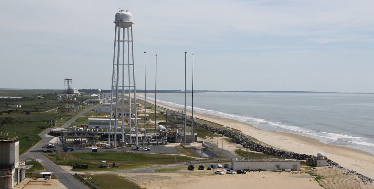
LADEE Launch Pad 0B at NASA Wallops Flight Facility in Virginia. Credit: Ken Kremer/kenkremer.comAerial view of NASA Wallops launch site on Virginia shore shows launch pads for both suborbital and orbital rockets. The Antares rocket Pad 0A for missions to the ISS is in the foreground. Suborbital rockets blast off just behind the Pad 0A water tower. This photo was snapped from on top of Pad 0B that will soon launch NASA‘s LADEE orbiter to the Moon. Credit: Ken Kremer- kenkremer.com
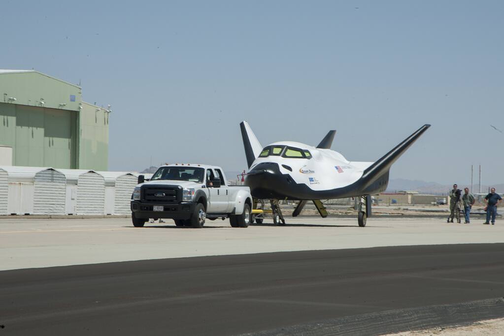
Sierra Nevada Corporation's Dream Chaser successfully rolls through two tow tests at NASA's Dryden Flight Research Center in California in preparation for future flight testing
Sierra Nevada Corporation’s Dream Chaser successfully rolls through two tow tests at NASA’s Dryden Flight Research Center in California in preparation for future flight testing later this year. Watch way cool Dream Chaser assembly video below![/caption]
Sierra Nevada Corporation’s winged Dream Chaser engineering test article is moving forward with a series of ground tests at NASA’s Dryden Flight Research Center in California that will soon lead to dramatic aerial flight tests throughout 2013.
Pathfinding tow tests on Dryden’s concrete runway aim to validate the performance of the vehicles’ nose skid, brakes, tires and other systems to prove that it can safely land an astronaut crew after surviving the searing re-entry from Earth orbit.
The Dream Chaser is one of the three types of private sector ‘space taxis’ being developed with NASA seed money to restore America’s capability to blast humans to Earth orbit from American soil – a capability which was totally lost following the forced shutdown of NASA’s Space Shuttle program in 2011.
Dream Chaser commercial crew vehicle built by Sierra Nevada Corp docks at ISS
For the initial ground tests, the engineering test article was pulled by a tow truck at 10 and 20 MPH. Later this month tow speeds will be ramped up to 40 to 60 MPH.
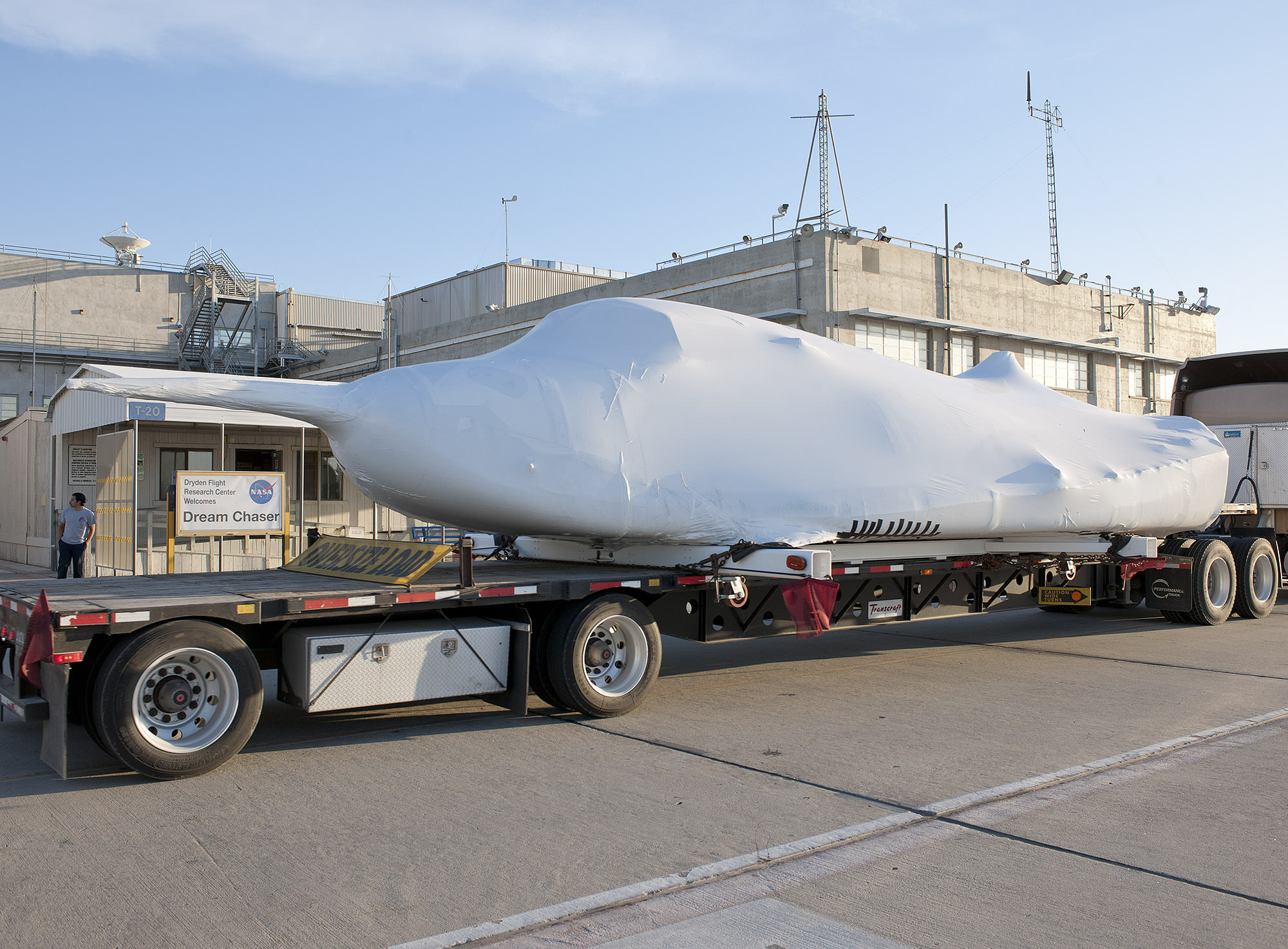
Final assembly of the Dream Chaser test vehicle was completed at Dryden with installation of the wings and tail, following shipment from SNC’s Space Systems headquarters in Louisville, Colo.
Watch this exciting minute-long, time-lapse video showing attachment of the wings and tail:
In the next phase later this year, Sierra Nevada will conduct airborne captive carry tests using an Erickson Skycrane helicopter.
Atmospheric drop tests of the engineering test article in an autonomous free flight mode for Approach and Landing Tests (ALT) will follow to check the aerodynamic handling.
The engineering test article is a full sized vehicle.
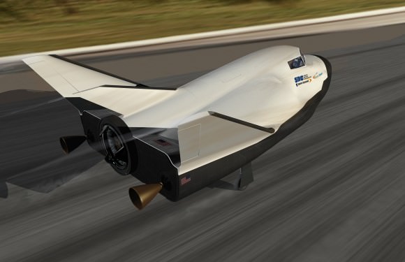
Dream Chaser is a reusable mini shuttle that launches from the Florida Space Coast atop a United Launch Alliance Atlas V rocket and lands on the shuttle landing facility (SLF) runway at the Kennedy Space Center, like the Space Shuttle.
“It’s not outfitted for orbital flight. It is outfitted for atmospheric flight tests,” said Marc Sirangelo, Sierra Nevada Corp. vice president and SNC Space Systems chairman, to Universe Today.
“The best analogy is it’s very similar to what NASA did in the shuttle program with the Enterprise, creating a vehicle that would allow it to do significant flights whose design then would filter into the final vehicle for orbital flight,” Sirangelo told me.
NASA’s Dryden Flight Research Center welcomes SNC’s Dream Chaser shrink wrapped engineering test article for a flight test program in collaboration with NASA’s Commercial Crew Program this summer. Winds and tail were soon joined and ground testing has now begun. Credit: NASA/Tom Tschida
Sierra Nevada Corp, along with Boeing and SpaceX are working with NASA in a public-private partnership using a combination of NASA seed money and company funds.
Each company was awarded contracts under NASA’s Commercial Crew Integrated Capability Initiative, or CCiCap, program, the third in a series of contracts aimed at kick starting the development of the private sector ‘space taxis’ to fly US and partner astronauts to and from low Earth orbit (LEO) and the International Space Station (ISS).
“We are the emotional successors to the shuttle,” says Sirangelo. “Our target was to repatriate that industry back to the United States, and that’s what we’re doing.”
The combined value of NASA’s Phase 1 CCiCap contracts is about $1.1 Billion and runs through March 2014.
Phase 2 contract awards will eventually lead to actual flight units after a down selection to one or more of the companies.
Everything depends on NASA’s approved budget, which seems headed for steep cuts in excess of a billion dollars if the Republican dominated US House has its way.
Dream Chaser awaits launch atop Atlas V rocket
The Commercial Crew program’s goal is to ensure the nation has safe, reliable and affordable crew transportation systems to space.
“Unique public-private partnerships like the one between NASA and Sierra Nevada Corporation are creating an industry capable of building the next generation of rockets and spacecraft that will carry U.S. astronauts to the scientific proving ground of low-Earth orbit,” said William Gerstenmaier, NASA’s associate administrator for human exploration and operations in Washington, in a statement.
“NASA centers around the country paved the way for 50 years of American human spaceflight, and they’re actively working with our partners to test innovative commercial space systems that will continue to ensure American leadership in exploration and discovery.”
All three commercial vehicles – the Boeing CST-100; SpaceX Dragon and Sierra Nevada Dream Chaser – are designed to carry a crew of up to 7 astronauts and remain docked at the ISS for more than 6 months.
The first orbital flight test of the Dream Chaser is not expected before 2016 and could be further delayed if NASA’s commercial crew budget is again slashed by the Congress – as was done the past few years.
In the meantime, US astronauts are totally dependent on Russia’s Soyuz capsule for rides to the ISS. NASA must pay Russia upwards of $70 million per seat until the space taxis are ready for liftoff – perhaps in 2017.
“We have got to get Commercial Crew funded, or we’re going to be paying the Russians forever,” said NASA Administrator Charles Bolden at Dryden. “Without Commercial Crew, we probably won’t have exploration.”
Concurrently, NASA is developing the Orion Crew capsule for missions to the Moon, Asteroids and beyond to Mars and other destinations in our Solar System -details here.
Scale models of NASA’s Commercial Crew program vehicles and launchers; Boeing CST-100, Sierra Nevada Dream Chaser, SpaceX Dragon.
Credit: Ken Kremer/kenkremer.comSierra Nevada Corp.’s Dream Chaser spacecraft landing on a traditional runway. Dream Chaser is being developed in collaboration with NASA’s Commercial Crew Program during the Commercial Crew Integrated Capability initiative (CCiCAP). Credit: Sierra Nevada Corp.
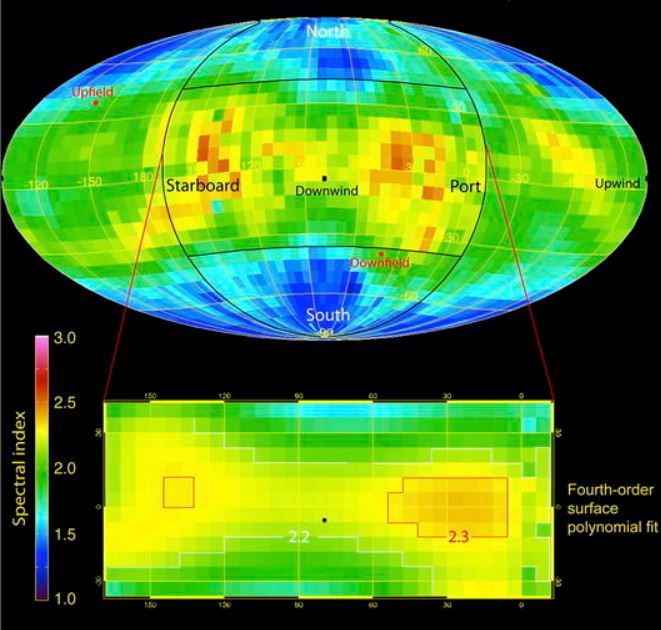
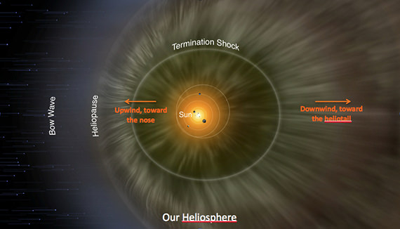
IBEX observations of spectral slope, where red and yellow indicate lower energy particles and green and blue higher energy ones. The central portion (circle) is looking down the heliotail and shows two lower energy “lobes” on the port and starboard sides and high energy regions at higher northern and southern latitudes.
Figure taken from McComas et al. , Astrophysical Journal, 2013.
Our Solar System is moving through interstellar space and scientists have long thought that the “bubble” around our Solar System – called the heliosphere – might have a tail, similar to how a comet has a tail or how other stars have astrospheres. But that has all been conjecture…. until now.
The IBEX spacecraft (Interstellar Boundary Explorer) has now seen the tail and has mapped out its structure. IBEX scientists were surprised to see the tail has twists and turns, with four separate “lobes,” making it appear somewhat like a four-leaf clover. This downwind region of the heliosphere is called the heliotail.
“Scientists have always presumed that the heliosphere had a tail,” said Eric Christian, IBEX mission scientist, speaking during a Google+ Hangout announcing the new findings. “But this is actually the first real data that we have to give us the shape of the tail.”
IBEX measures the neutral particles created by collisions at the solar system’s boundaries. This technique, called energetic neutral atom imaging, relies on the fact that the paths of neutral particles are not affected by the solar magnetic field. Instead, the particles travel in a straight line from collision to IBEX. Consequently, observing where the neutral particles came from describes what is going on in these distant regions.
“By collecting these energetic neutral atoms, IBEX provides maps of the original charged particles,” said David McComas, lead author on the team’s paper and principal investigator for IBEX at Southwest Research Institute. “The structures in the heliotail are invisible to our eyes, but we can use this trick to remotely image the outermost regions of our heliosphere.”
What they found was unexpected, McComas said.
“By very carefully assembling the statistical observations from the first three years of IBEX data we’ve been able to fill in what we couldn’t see before,” McComas said during the Hangout, “and what we found was that the heliotail was a much larger structure with a much more interesting configuration.
What they found was a tail that appears to have a combination of fast and slow moving particles. There are two lobes of slower particles on the sides, with faster particles above and below. The entire structure is twisted from the pushing and pulling of magnetic fields outside the solar system. McComas likened it to a how a beach ball might twist around if it was attached to a bungee cord.
The IBEX scientists speaking during the Hangout today said this new information will help us understand what the Voyager spacecraft may encounter as they reach the edge of our Solar System.
“IBEX and Voyager are incredibly complimentary missions,” said Christian. “I’ve often said that IBEX is like an MRI, where it can take an image to understand the big picture of what is going on, where the Voyagers are like biopsies, where we can see what is going on in the local area.”
This was the first time a NASA used a Google+ Hangout to broadcast a press briefing. You can watch the full Hangout below:
You can read David McComas’ blog post on the new findings here, and NASA’s press release here.
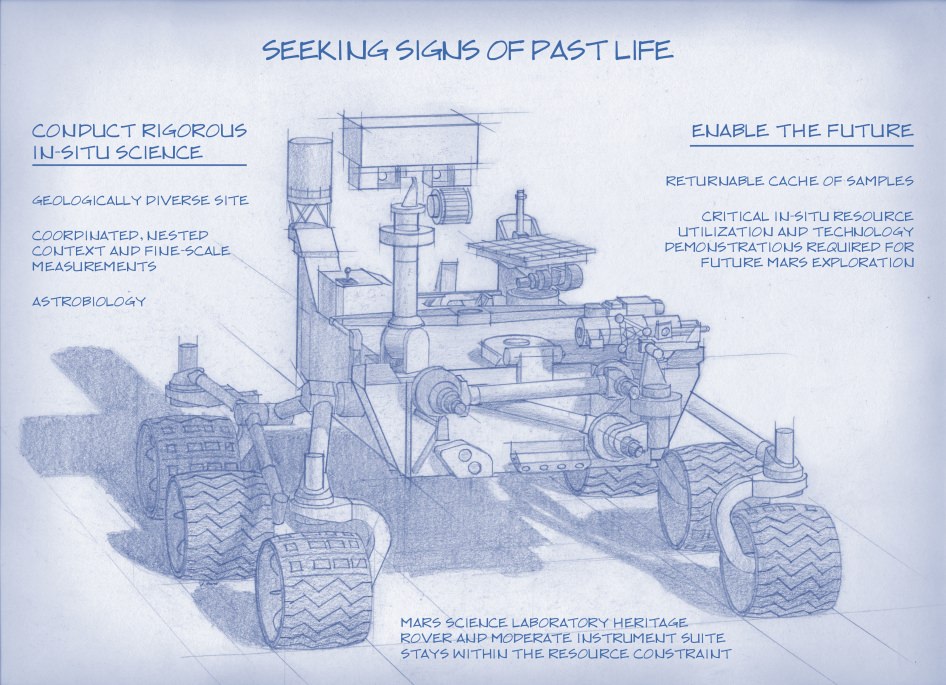
Artist's Concept of NASA’s Mars 2020 Rover envisions a basic structure that capitalizes on re-using the design and engineering work done for the NASA rover Curiosity, which landed on Mars in 2012, but with new science instruments for accomplishing different science objectives with the 2020 mission. Credit: NASA/JPL-Caltech
NASA’s next Mars rover set for liftoff in 2020 should focus on three primary objectives; seeking signs of past life, collecting a cache of carefully chosen samples for eventual return to Earth and developing technologies that will help enable future human missions to the Red Planet some two decades from now.
The 2020 goals were laid out publicly today (July 9) by a panel of scientists on the ‘Science Definition Team’ and charged by NASA with defining the key science objectives for the new mission.
The science objectives and how to accomplish them are outlined in considerable detail in a newly issued 154 page report handed over to the space agency and discussed at today’s NASA briefing for the media.
Looking for signs of ancient life and preserved biosignatures on Mars at a place that was once habitable is the top priority of the 2020 mission. The SDT report states that the landing site should be chosen specifically to “explore the geology of a once habitable site.”
“We need a highly mobile rover that can make ‘in situ’ science measurements,” said Jack Mustard, chairman of the Science Definition Team and a professor at the Geological Sciences at Brown University in Providence, R.I., at the briefing.
“The rover would use its own instruments on Mars for visual, mineralogical and chemical analysis down to a microscopic scale to identify candidate features that may have been formed by past life,” states the SDT report.
“We can’t do this now with Curiosity,” explained Mustard. “We need higher resolution.”
Looking for ‘extant’ life, that is life surviving on Mars today, would be a by-product of the search for organic molecules and preserved biosignatures of life – past or present.
The Mars 2020 ‘Science Definition Team’ (SDT) is comprised of 19 scientists and engineers from academia and industry. They were appointed by NASA in January 2013 to thoroughly and quickly evaluate a wide range of options to accomplish the highest priority planetary science objectives and achieve President Obama’s challenge to send humans to Mars in the 2030s.
Retrieving soil and rock samples from Mars for analysis back on Earth by research teams worldwide using all the most advanced analytical instruments available to humankind with unprecedented capability has been the ‘Holy Grail’ of Mars exploration for several decades.
But the enormous cost and technical complexity of a Mars Sample Return (MSR) mission has caused it to be repeatedly postponed.
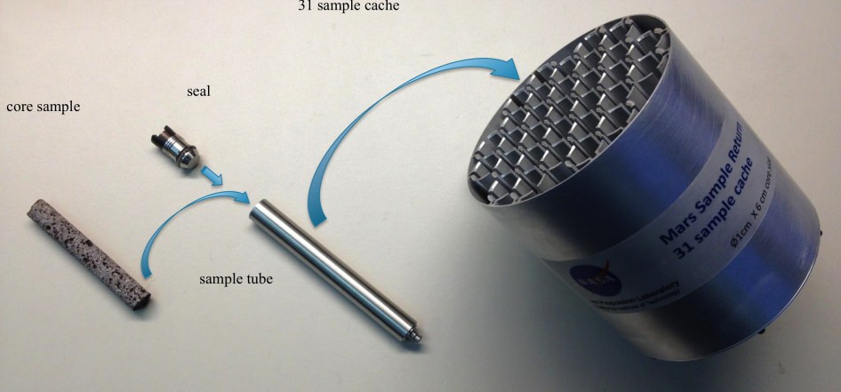
Creating a Returnable Cache of Martian Samples is a major objective for NASA’s Mars 2020 rover. This prototype show hardware to cache samples of cores drilled from Martian rocks for possible future return to Earth. The 2020 rover would be to collect and package a carefully selected set of up to 31 samples in a cache that could be returned to Earth by a later mission. The capabilities of laboratories on Earth for detailed examination of cores drilled from Martian rocks would far exceed the capabilities of any set of instruments that could feasibly be flown to Mars. The exact hardware design for the 2020 mission is yet to be determined. For scale, the diameter of the core sample shown in the image is 0.4 inch (1 centimeter). Credit: NASA/JPL-Caltech
The 2020 rover will be designed to make real progress on sample return for the first time. It will be capable of coring into rocks and storing 31 highly compelling Martian samples for return by a follow on mission to the Red Planet.
“But the timing on actually returning those samples to Earth is yet to be determined,” said John Grunsfeld, NASA’s associate administrator for science in Washington.
Everything NASA does is budget driven and the fiscal climate is rather gloomy right now.
“Crafting the science and exploration goals is a crucial milestone in preparing for our next major Mars mission,” said John Grunsfeld, NASA’s associate administrator for science in Washington, in a statement.
Work on the new rover must begin soon in order to achieve the mandatory 2020 launch deadline. Launch opportunities to Mars only open every 26 months and delays could balloon the costs by several hundred million dollars.
“The objectives determined by NASA with the input from this team will become the basis later this year for soliciting proposals to provide instruments to be part of the science payload on this exciting step in Mars exploration,” adds Grunsfeld.
“The 2020 rover will take a major step in ‘seeking signs of life” said Jim Green, director of NASA’s Planetary Science Division in Washington, at the briefing. “NASA will issue a call for science instruments this fall.”
The new mission would build upon the demonstrated science accomplishments of earlier missions like Curiosity, Spirit, Opportunity and Phoenix while vastly advancing the capabilities of the robots research instruments.
“Here’s the bottom line. Questions drive science,” explained Lindy Elkins-Tanton, SDT member and director of the Carnegie Institution for Science’s Department of Terrestrial Magnetism, Washington.
“We should be seeking to answer the very biggest questions. And one of the very biggest questions for all of humankind is – ‘Are we alone?’ And that is the question we’re hoping to make really big advances with on with this Mars 2020 mission.”
Grunsfeld explained that NASA has budgeted “for a mission cost of $1.5 Billion plus the cost of the launcher.”
The 2020 rover chassis, with some modifications, will be based on the blueprints of the highly successful Curiosity rover to keep down the cost and minimize risks. But the science instruments will be completely new and updated.
NASA’s 1 ton Curiosity rover touched down nearly a year ago and has already discovered that the Red Planet has the chemical ingredients and environmental conditions for a habitable zone that could have supported living Martian microbes.
The next logical step is to look for the ancient signs of life that would be preserved in the rock record on Mars.
NASA’s 2020 Mars rover would be based on the Curiosity rover which touched down inside Gale Crater on Aug. 6, 2012 and discovered a habitable zone here. This photomosic shows NASA’s Curiosity departing Glenelg work site area at last for Mount Sharp- her main science destination, seen at top left. Note the wheel tracks on the Red Planet’s surface. The mosaic of navcam camera images was stitched from photos taken on July 4, 2013 (Sol 324). Credit: NASA/JPL-Caltech/Ken Kremer (kenkremer.com)/Marco Di Lorenzo
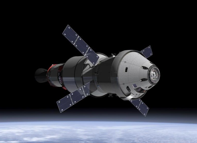
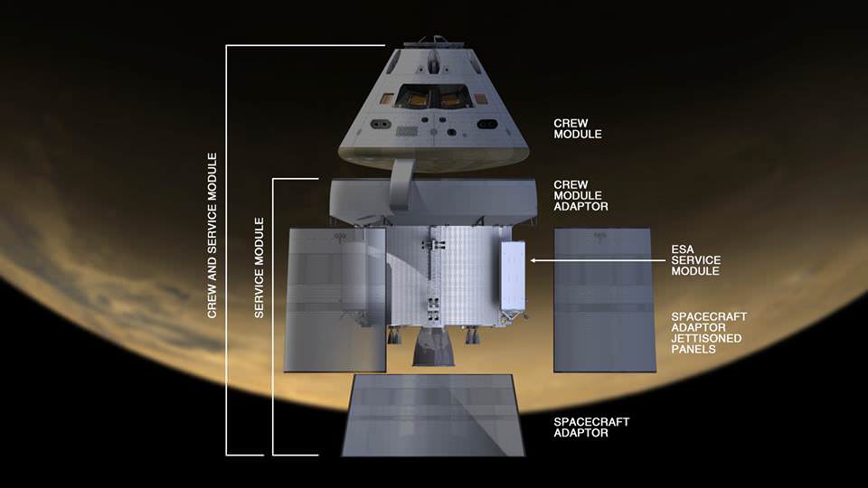
NASA Orion spacecraft blasts off atop 1st Space Launch System rocket in 2017 - attached to European provided service module – on an enhanced m mission to Deep Space where an asteroid could be relocated as early as 2021. Credit: NASA
NASA Orion spacecraft blasts off atop 1st Space Launch System rocket in 2017 – attached to European provided service module – on an ambitious mission to explore Deep Space some 40,000 miles beyond the Moon, where an asteroid could be relocated as early as 2021. Credit: NASA Story updated with further details[/caption]
NASA managers have announced a bold new plan to significantly alter and upgrade the goals and complexity of the 1st mission of the integrated Orion/Space Launch System (SLS) human exploration architecture – planned for blastoff in late 2017.
The ambitious first flight, called Exploration Mission 1 (EM-1), would be targeted to send an unpiloted Orion spacecraft to a point more than 40,000 miles (70,000 kilometers) beyond the Moon as a forerunner supporting NASA’s new Asteroid Redirect Initiative – recently approved by the Obama Administration.
The EM-1 flight will now serve as an elaborate harbinger to NASA’s likewise enhanced EM-2 mission, which would dispatch a crew of astronauts for up close investigation of a small Near Earth Asteroid relocated to the Moon’s vicinity.
Orion crew module separates from Space Launch System (SLS) upper stage. Credit: NASA
Until recently NASA’s plan had been to launch the first crewed Orion atop the 2nd SLS rocket in 2021 to a high orbit around the moon on the EM-2 mission, said NASA Associate Administrator Lori Garver in an prior interview with me at the Kennedy Space Center.
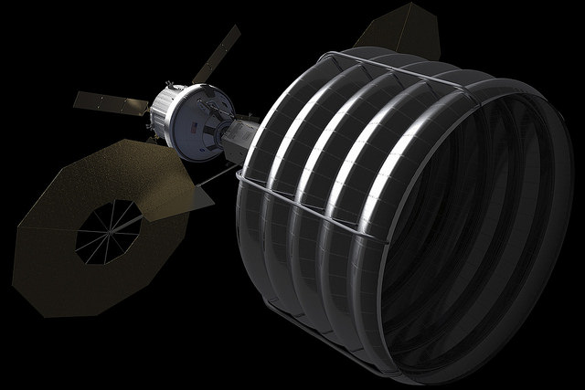
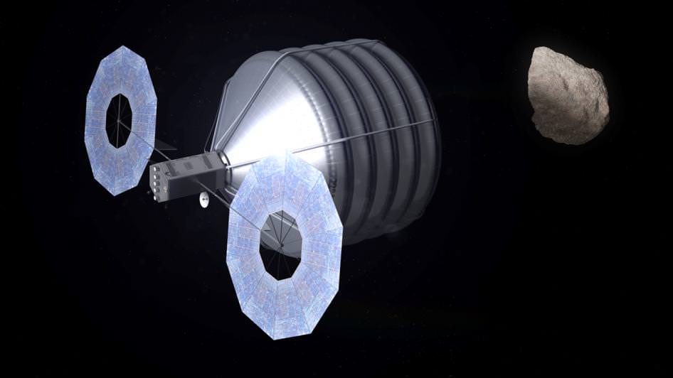
Concept of NASA spacecraft with Asteroid capture mechanism deployed to redirect a small space rock to a stable lunar orbit for later study by astronauts aboard Orion crew capsule. Credit: NASA.
The enhanced EM-1 flight would involve launching an unmanned Orion, fully integrated with the Block 1 SLS to a Deep Retrograde Orbit (DRO) near the moon, a stable orbit in the Earth-moon system where an asteroid could be moved to as early as 2021.
Orion’s mission duration would be nearly tripled to 25 days from the original 10 days.
“The EM-1 mission with include approximately nine days outbound, three to six days in deep retrograde orbit and nine days back,” Brandi Dean, NASA Johnson Space Center spokeswoman told Universe Today exclusively.
The proposed much more technologically difficult EM-1 mission would allow for an exceptionally more vigorous work out and evaluation of the design of all flight systems for both Orion and SLS before risking a flight with humans aboard.
Asteroid Capture in Progress
A slew of additional thruster firings would exercise the engines to change orbital parameters outbound, around the moon and inbound for reentry.
The current Deep Retrograde Orbit (DRO) plan includes several thruster firings from the Orion service module, including a powered lunar flyby, an insertion at DRO, an extraction maneuver from the DRO and a powered flyby on return to Earth.
Orion would be outfitted with sensors to collect a wide variety of measurements to evaluate its operation in the harsh space environment.
“EM-1 will have a compliment of both operational flight instrumentation and development flight instrumentation. This instrumentation suite gives us the ability to measure many attributes of system functionality and performance, including thermal, stress, displacement, acceleration, pressure and radiation,” Dean told me.
The EM-1 flight has many years of planning and development ahead and further revisions prior to the 2017 liftoff are likely.
“Final flight test objectives and the exact set of instrumentation required to meet those objectives is currently under development,” Dean explained.
Orion is NASA’s next generation manned space vehicle following the retirement of NASA’s trio of Space Shuttles in 2011.
The SLS launcher will be the most powerful and capable rocket ever built by humans – exceeding the liftoff thrust of the Apollo era Moon landing booster, the mighty Saturn V.
“We sent Apollo around the moon before we landed on it and tested the space shuttle’s landing performance before it ever returned from space.” said Dan Dumbacher, NASA’s deputy associate administrator for exploration systems development, in a statement.
“We’ve always planned for EM-1 to serve as the first test of SLS and Orion together and as a critical step in preparing for crewed flights. This change still gives us that opportunity and also gives us a chance to test operations planning ahead of our mission to a relocated asteroid.”
Both Orion and SLS are under active and accelerating development by NASA and its industrial partners.
The 1st Orion capsule is slated to blast off on the unpiloted EFT-1 test flight in September 2014 atop a Delta IV Heavy rocket on a two orbit test flight to an altitude of 3,600 miles above Earth’s surface.
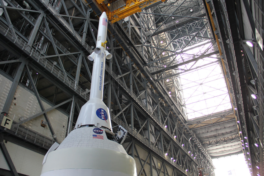
Technicians work on mockups of the Orion crew capsule, Service Module and 6 ton Launch Abort System (LAS) to simulate critical assembly techniques inside the Vehicle Assembly Building (VAB) at NASA’s Kennedy Space Center (KSC) in Florida for the EFT-1 mission due to liftoff in September 2014. Credit: Ken Kremer/kenkremer.com
It will then reenter Earth’s atmosphere at speeds of about 20,000 MPH (11 km/sec) and endure temperatures of 4,000 degrees Fahrenheit in a critical test designed to evaluate the performance of Orion’s heatshield and numerous spacecraft systems.
Orion EFT-1 is already under construction at the Kennedy Space Center (KSC) by prime contractor Lockheed Martin – read my earlier story here.
Integration and stacking tests with Orion’s emergency Launch Abort System are also in progress at KSC – details here.
NASA says the SLS is also in the midst of a extensive review process called the Preliminary Design Review (PDR) to ensure that all launch vehicle components and systems will achieve the specified performance targets and be completed in time to meet the 2017 launch date. The PDR will be completed later this summer.
NASA’s goal with Orion/SLS is to send humans to the Moon and other Deep Space destinations like Asteroids and Mars for the first time in over forty years since the final manned lunar landing by Apollo 17 back in 1972.
NASA Headquarters will make a final decision on upgrading the EM-1 mission after extensive technical reviews this summer.