Despite Dust Storms, Solar Power is Best for Mars Colonies

Spot the difference: Spirits solar panels collected a lot of dust in two years (NASA/JPL)

[/caption]

Dust — a solar panel’s worst nightmare.

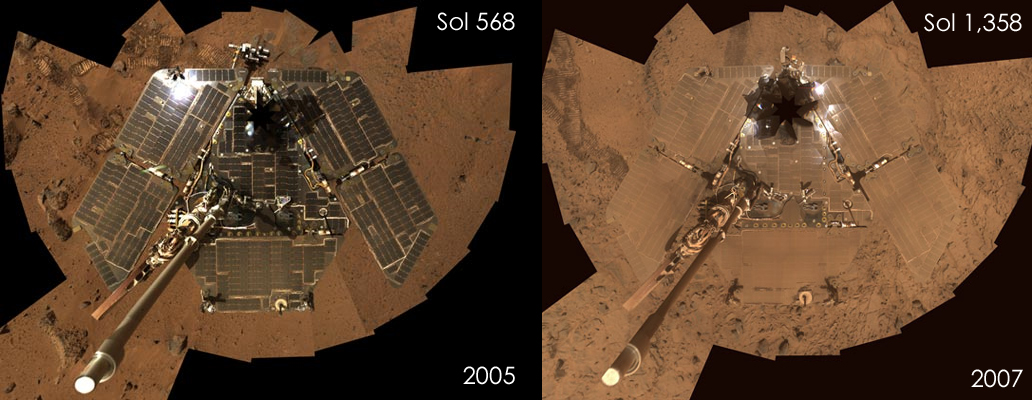
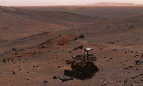
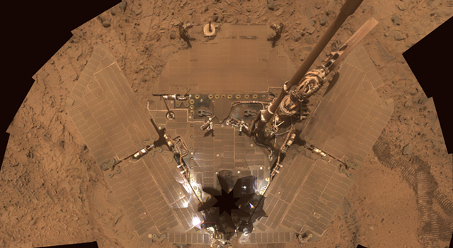
Is sending solar-powered robots to the Red Planet a bad idea? Mars is a very dusty planet, and Mars dust sticks to everything, especially solar arrays. After all, Phoenix’s death was probably hastened by a Sun-blocking dust storm, and rover Spirit was battered by the combined solar panel-coated dust layer plus dust storm, nearly draining its batteries (as can be seen in the comparison above, after two years on the Martian surface, Spirit’s dusty layer was already an acute problem).

However, a NASA-sponsored MIT think-tank has weighed up the future energy needs of a manned settlement on Mars and arrived at an interesting conclusion…

It sounds like the “nuclear space debate” continues. Thinking back to when Galileo was launched toward Jupiter in 1989, or when Cassini was sent to Saturn in 1997, huge protests erupted from critics, Cape Canaveral neighbours and anti-nuclear organizations. The argument was that should there be a launch accident, the radioactive material contained inside the radioisotope thermal generators (RTGs) could be scattered through the atmosphere and over a wide area on the ground (i.e. death and destruction). While this is a scary thought, NASA engineers were very quick to point out that RTGs are virtually indestructible, even under extreme conditions during an explosion and atmospheric re-entry.

The motivation for sending plutonium (non-weapon grade Pu238) on board missions to Jupiter and Saturn has even been called into question, spawning wild conspiracy theories such as “Project Lucifer.” Therefore, it seems only sensible that NASA should want to carry out an in-depth study of all energy production techniques before committing to a potentially unpopular (and therefore politically damaging) nuclear source for future Mars colonies.

With the help of energy specialists from the Massachusetts Institute of Technology (MIT), NASA commissioned a study of how future manned Mars settlements can be powered. Will nuclear generators need to be constructed? Or can solar panels fulfil our proto-colony’s energy needs (regardless of the dust situation)?

Interestingly, if positioned in the correct location, solar arrays might function just as well, if not better, than the nuclear options. Solar panels could provide all the energy a fledgling colony needs.

The MIT researchers assessed 13 different energy generation systems and compared solar and nuclear options. In a presentation last month at the International Astronautical Congress in Glasgow, MIT engineer Wilfried Hofstetter compared nuclear fission reactors, RTGs, Sun-tracking solar panel arrays and non-tracking thin-film solar arrays laid atop the Martian landscape.

Like any space travel endeavour, efficiency is paramount; astronauts will need to utilize every last energy-generating ounce of equipment sent to Mars (including back-up systems).

It would appear that a large solar panel array can match nuclear generators, only if they are situated at a latitude of 0-40° north of the Martian equator. Southern latitudes have much less solar energy available for most of the year.

So what’s the best plan of action? According to Hofstetter, a Mars mission should be able to transport several 2 metre-wide rolls of thin-film solar panel arrays. Rolling out an array of these thin-film rolls could supply ample energy to a colony. For example, if the array is positioned at 25° north, measuring 100×100 metres, 100 kilowatts can be generated. The MIT researchers even calculated it would take two astronauts 17 hours to construct the array (alternatively they could get a robot to do it).

Commenting on this Mars energy solution, Colin Pillinger, planetary scientist with the Open University, UK (and head Beagle 2 scientist) said the solar array’s old foe — dust — shouldn’t be too much of a problem after all. “Dust storms tend to start in well-known places in the southern hemisphere as it warms up, so it shouldn’t be too difficult to avoid them,” he said.

So the skies may be clear for solar energy on Mars after all. Even though dust storms causes problems for our robotic explorers, manned expeditions may be able to avoid them all together. Besides, I don’t see why astronauts couldn’t pack some brushes to wipe down the arrays should dust become a problem…

Source: New Scientist

MSL News: Landing Sites and Naming Contest

Landing sites for the Mars Science Laboratory have been narrowed down to four intriguing places on the Red Planet. The car-sized rover will have the capability to travel to more scientifically compelling sites, and with its radioisotope power source, it won’t need to rely on solar power, allowing for more flexibility in locations say project leaders at the Jet Propulsion Laboratory. After seeking input from international experts on Mars and engineers working on the landing systems, here are the four sites JPL announced (drumroll)…

Oh, before listing the sites, NASA is having a name the rover contest for MSL, so check that out, too!

Eberswalde: where an ancient river deposited a delta in a possible lake, south of Mars equator.

Gale: a crater with a mountain within that has stacked layers including clays and sulfates, near the equator. This was a favorite site for the Mars Exploration Rovers, but it was deemed to hazardous for them. Not so for MSL.

Holden: a crater containing alluvial fans, flood deposits, possible lake beds and clay-rich deposits, in the southern hemisphere.

Mawrth: , which shows exposed layers containing at least two types of clay, in the northern hemisphere, near the edge of a vast Martian highland.

“All four of these sites would be great places to use our roving laboratory to study the processes and history of early Martian environments and whether any of these environments were capable of supporting microbial life and its preservation as biosignatures,” said John Grotzinger of the California Institute of Technology, Pasadena. He is the project scientist for the Mars Science Laboratory.

Wheels were put on MSL in August 2008. Image Credit: NASA/JPL-Caltech

During the past two years, multiple observations of dozens of candidate sites by NASA’s Mars Reconnaissance Orbiter have augmented data from earlier orbiters for evaluating sites’ scientific attractions and engineering risks.

JPL is assembling and testing the Mars Science Laboratory spacecraft for launch in fall 2009.

“Landing on Mars always is a risky balance between science and engineering. The safest sites are flat, but the spectacular geology is generally where there are ups and downs, such as hills and canyons. That’s why we have engineered this spacecraft to make more sites qualify as safe,” said JPL’s Michael Watkins, mission manager for the Mars Science Laboratory. “This will be the first spacecraft that can adjust its course as it descends through the Martian atmosphere, responding to variability in the atmosphere. This ability to land in much smaller areas than previous missions, plus capabilities to land at higher elevations and drive farther, allows us consider more places the scientists want to explore.”

MSL is designed to hit a target area roughly 20 kilometers (12 miles) in diameter. Also, a new “skycrane” technology to lower the rover on a tether for the final touchdown can accommodate more slope than the airbag method used for Spirit and Opportunity.

Source: JPL

MRO Finds Huge Underground Glaciers on Mars

Possible underground glaciers on Mars. Credit: NASA

[/caption]
There’s more than just a little ice under Mars’ surface. According to data from the Mars Reconnaissance Orbiter radar system, vast Martian glaciers of water ice lie buried under rocky debris. And this ice is not just at the Arctic region where the Phoenix lander scratched the surface in searching for ice. MRO found evidence for a huge amount of underground ice at much lower latitudes than any ice previously identified on the Red Planet. “Altogether, these glaciers almost certainly represent the largest reservoir of water ice on Mars that is not in the polar caps,” said John W. Holt of the University of Texas at Austin, who is lead author of the report. “Just one of the features we examined is three times larger than the city of Los Angeles and up to half a mile thick. And there are many more. In addition to their scientific value, they could be a source of water to support future exploration of Mars.”


Scientists say buried glaciers extend for dozens of miles from the edges of mountains or cliffs. A layer of rocky debris blanketing the ice may have preserved the underground glaciers as remnants from an ice sheet that covered middle latitudes during a past ice age. This discovery is similar to massive ice glaciers that have been detected under rocky coverings in Antarctica.

Scientists have been puzzled by what are known as aprons — gently sloping areas containing rocky deposits at the bases of taller geographical features — since NASA’s Viking orbiters first observed them on the Martian surface in the1970s. One theory has been that the aprons are flows of rocky debris lubricated by a small amount ice. Now, the shallow radar instrument on the Mars Reconnaissance Orbiter has provided scientists an answer to this Martian puzzle.

“These results are the smoking gun pointing to the presence of large amounts of water ice at these latitudes,” said Ali Safaeinili, a shallow radar instruments team member with NASA’s Jet Propulsion Laboratory in Pasadena, Calif.

The buried glaciers lie in the Hellas Basin region of Mars’ southern hemisphere. The radar also has detected similar-appearing aprons extending from cliffs in the northern hemisphere.

Artists concept of a glacier on Mars.  Credit: NASA
Artists concept of a glacier on Mars. Credit: NASA

Radar echoes received by the spacecraft indicated radio waves pass through the aprons and reflect off a deeper surface below without significant loss in strength. That is expected if the apron areas are composed of thick ice under a relatively thin covering. The radar does not detect reflections from the interior of these deposits as would occur if they contained significant rock debris. The apparent velocity of radio waves passing through the apron is consistent with a composition of water ice.

“There’s an even larger volume of water ice in the northern deposits,” said JPL geologist Jeffrey J. Plaut, who will be publishing results about these deposits in the American Geophysical Union’s Geophysical Research Letters. “The fact these features are in the same latitude bands, about 35 to 60 degrees in both hemispheres, points to a climate-driven mechanism for explaining how they got there.”

The rocky debris blanket topping the glaciers apparently has protected the ice from vaporizing, which would happen if it were exposed to the atmosphere at these latitudes.

“A key question is, how did the ice get there in the first place?” said James W. Head of Brown University in Providence, R.I. “The tilt of Mars’ spin axis sometimes gets much greater than it is now. Climate modeling tells us ice sheets could cover mid-latitude regions of Mars during those high-tilt periods. The buried glaciers make sense as preserved fragments from an ice age millions of years ago. On Earth, such buried glacial ice in Antarctica preserves the record of traces of ancient organisms and past climate history.”

Source: NASA

Evidence For Vast Oceans On Ancient Mars

This 3D map superimposes gamma-ray data from Mars Odyssey's Gamma-Ray Spectrometer onto topographic data from the laser altimeter onboard the Mars Global Surveyor.

[/caption]
Data from the Mars Odyssey orbiter’s Gamma Ray Spectrometer provides new evidence for the controversial idea that oceans once covered about a third of ancient Mars. Spacecraft images going back to Mariner 9 in the early 1970s and the Viking orbiters and landers later in the 1970s up to the current orbiters and rovers have showed widespread evidence for a watery past for Mars. About 20 years ago, several studies sparked a scientific debate on the possible existence of ancient Martian oceans marked by visible shorelines. Images and topographic maps provide evidence for two different oceans in one area, perhaps occuring at different times in Mars history, a larger one at an earlier time, and a smaller once existing later. Odyssey’s GRS can detect subsurface elements, and new data confirms the right combination of elements for two ancient shorelines.

The spectrometer has the unique ability to detect elements buried as much as 1/3 meter, or 13 inches, below the surface by the gamma rays they emit. That capability led to GRS’ 2002 discovery of water-ice near the surface near Mars arctic region, leading to the decision for the Phoenix landing site.

“Our investigation posed the question, ‘Might we see a greater concentration of these elements within the ancient shorelines because water and rock containing the elements moved from the highlands to the lowlands, where they eventually ponded as large water bodies?'” said University of Arizona planetary geologist James M. Dohm, who led the international investigation. “We compared Gamma Ray Spectrometer data on potassium, thorium and iron above and below a shoreline believed to mark an ancient ocean that covered a third of Mars’ surface, and an inner shoreline believed to mark a younger, smaller ocean.”

Results suggest that past watery conditions likely leached, transported and concentrated such elements as potassium, thorium and iron, Dohm said. “The regions below and above the two shoreline boundaries are like cookie cutouts that can be compared to the regions above the boundaries, as well as the total region.”

The younger, inner shoreline is evidence that an ocean about 10 times the size of the Mediterranean Sea, or about the size of North America, existed on the northern plains of Mars a few billion years ago. The larger, more ancient shoreline that covered a third of Mars held an ocean about 20 times the size of the Mediterranean, the researchers estimate.

The potassium-thorium-iron enriched areas occur below the older and younger paleo-ocean boundaries with respect to the entire region, they said. The scientists used data from Mars Global Surveyor’s laser altimeter for topographic maps of the regions in their study.

Scientists studying spacecraft images have a hard time confirming “shoreline” landforms, the researchers said, because Mars shorelines would look different from Earth’s shorelines. Earth’s coastal shorelines are largely a direct result of powerful tides caused by gravitational interaction between Earth and the moon, but Mars lacks a sizable moon. Another difference is that lakes or seas on Mars could have formed largely from giant debris flows and liquefied sediments. Still another difference is that Mars oceans may have been ice-covered, which would prevent wave action.

“The GRS adds key information to the long-standing oceans-on-Mars controversy,” Dohm said. “But the debate is likely to continue well into the future, perhaps even when scientists can finally walk the Martian surface with instruments in hand, with a network of smarter spaceborne, airborne and ground-based robotic systems in their midst.”

Source: U of Arizona

Mars Rover Spirit Surviving on a Low Energy Diet

Spirit overlooking Gusev Crater (NASA artist impression)

[/caption]Last week, Mars Exploration Rover Spirit looked as if its sols were numbered. Hot on the heals of the demise of the frozen Phoenix lander, Spirit was about to succumb to a low-energy death brought on by a dust storm. The build-up of dust on the rover’s solar panels were already causing a serious problem, but as a storm raged over Gusev Crater, power output from the panels slumped to an all-time low. As Nancy reported on November 11th, mission controllers were forced to switch Spirit into a low-energy state, leaving them with no other choice but to command the robot to be silent. Although tensions were high, Spirit broke the silence last Thursday.

Now NASA controllers are working hard to manage Spirit’s power production, hopefully extending the life of the highly successful rover longer still…

At its worst, Spirit’s solar panels were outputting 89 watt hours of energy just before NASA mission control took decisive action by shutting down non-essential heaters on the rover. Before the storm, Spirit was already covered in a thick layer of dust from nearly five years of Mars roving, allowing only 33% of the sunlight falling on the panels to be used by the photovoltaic cells. During the storm, the dust situation had worsened, valuable sunlight was getting blocked by atmospheric dust clouds. Spirit was in trouble.

NASA/JPL-Caltech/Cornell
Spirit's solar panels were already very dusty a year ago (NASA)
At their peak, both Spirit and Opportunity were able to generate 700 watt hours of energy. Should their power output drop to 150 watt hours, batteries start to drain while running heaters to keep essential equipment and instrumentation warmed. Spirit’s 89 watt hours was therefore a dire situation. Fortunately after the intrepid rover rode out the storm and checked in with mission control, by the end of Thursday, NASA was pleased to see Spirit’s solar panels generating 161 watt hours of energy. After four days, the skies were clearing and Spirit could begin slowly recharging its batteries. However, the layer of dust on top of the solar panels had thickened, allowing 3% less light to get through.

Spirit is not out of the woods yet,” said Mars Exploration Rover (MER) Project Manager John Callas at NASA’s Jet Propulsion Laboratory. “The storm and all its dust have not gone away completely. And this is the time of the Martian year when storms like this can occur. So the plan ahead is to stay cautious with the rover and work on recharging the batteries while waiting out the rest of the storm’s activity.”

So, Spirit has been put on a low energy consumption diet. On Friday commands were sent to the rover to keep some of its heaters switched off and to conduct limited observations and communications. Spirit will be on a “go-slow” until the end of the month to give it some time to recover, recharge and be prepared in the event of a follow-up Gusev Crater storm.

At the end of the month no commands will be sent from Earth for a period of two weeks, as the Sun will be blocking the line of sight with Mars. Therefore Spirit will have lots of time to recover from the dust storm ordeal until communications between Earth and Mars return. After this period, NASA plans to move Spirit from its current location inside Gusev Crater (a low platform called “Home Plate”) so it can continue to explore the Red Planet (assuming there are no more damaging storms ahead).

Although this is all a huge relief, I can’t help but think that Spirit is on borrowed time.

Source: NASA

Mars Rover Contact Reestablished, Spirit is Alive!

Relieved. MER Spirit (NASA)

[/caption]Just when we were growing concerned that we might be losing two Mars surface missions within a week of each other, it turns out Mars Exploration Rover Spirit has survived its recent run-in with a Sun-dimming dust storm. On Tuesday, Nancy reported that Spirit had generated a record low power output from its solar panels, indicating the storm could drive Spirit’s energy levels to a point where an emergency fail-safe would switch the wheeled robot into a sunlight-deprived coma. Mission controllers sent Spirit commands to shut down non-essential instrumentation and instructed it not to communicate with NASA until today.

It would appear the rugged rover weathered the storm, expertly avoided a low-power fault and after four days of silence, sent the signal to NASA just as it was told to do. What an incredible little robot

One might think that using solar panels to collect light on a planet where Sun-blocking dust is a problem is a bit silly. After all, it seems the Phoenix Mars lander succumbed to an arctic dust storm-induced drained battery, and Spirit was also hit by the solar panel’s old foe, a dust storm in Gusev Crater. But the key point that needs to be remembered in both cases is that these missions operated far beyond their expected lifespan. Phoenix was only supposed to be digging into the Martian dirt for three months (it lasted five months), plus the lander had a pretty tough deadline to keep to: the loss of sunlight and the freezing cold of the onset of the northern winter. Phoenix knew its fate, but it was able to push into the dark and cold for a little longer…

However, Spirit’s fate was far from sealed. Usually the rover enjoys a full sol of daylight, day and night as regular as clockwork. This is another piece of NASA engineering that has surpassed every expectation there is. I doubt that any scientist would have said that a mission designed to operate for only three months, would be roving the Martian surface nearly five years later! So already, every minute Spirit (and its twin rover Opportunity on the other side of the planet) spends transmitting data from the Red Planet is a huge bonus.

However, MER scientists were not going to let Spirit drop dead due to a flat battery. When NASA realised Spirit was beginning to suffer, drawing much less power than was needed from its solar panels, action was taken. Firstly, some heaters were switched off (one heater protects the thermal emission spectrometer instrument from the cold), and Spirit was put on a strict low-energy consumption routine. This routine meant commanding Spirit not to attempt to communicate with Earth for four days, which was probably the most nerve-racking measure that could be taken; once communication is severed, who’s to say we’d ever hear from the rover again?

Even though engineers had stopped Spirit from communicating, they continued to listen, just in case Spirit dropped into a low-energy shutdown mode. However, no signal was received until today (Thursday), right when Spirit was scheduled to phone home. At mission control at JPL in Pasadena, CA, NASA engineers shouted “she’s talking,” when they got word that Spirit had made contact.

Although her batteries are low, the rover is still working and talking with NASA. Let’s hope Spirit holds on for a while longer…

Source: AP

Spirit Rover in Trouble

The deck of NASA's Mars Exploration Rover Spirit is so dusty that the rover almost blends into the dusty background. Image credit: NASA/JPL-Caltech/Cornell

[/caption]
Martian dust storms are wreaking havoc with human spacecraft. Not only did a dust storm cut short the Phoenix lander’s extended mission, but now, another dust storm around Gusev Crater has cut into the amount of sunlight reaching the solar array on Spirit, one of the Mars Exploration Rovers, leaving the rover in serious trouble from diminished power. From the image above, it’s obvious Spirit’s solar panels are thickly coated with dust. Although this image was taken over a year ago, it’s likely the solar panels have only gotten worse.

Spirit’s solar array produced only 89 watt hours of energy during the rover’s 1,725th Martian day, which ended on Nov. 9. This is the lowest output by either Spirit or its twin, Opportunity, in their nearly five years on Mars, and much less energy than Spirit needs each day. The charge level of Spirit’s batteries is dropping so low, it risks triggering an automated response of the rover trying to protect itself.

“The best chance for survival for Spirit is for us to maintain sequence control of the rover, as opposed to it going into automated fault protection,” said John Callas of NASA’s Jet Propulsion Laboratory, Pasadena, Calif., project manager for Spirit and Opportunity.

Mission controllers are commanding Spirit to turn off some heaters, including one that protects a science instrument, the miniature thermal emission spectrometer, and take other measures to reduce energy consumption. The commands will tell Spirit not to try communicating again until Thursday. While pursuing that strategy the team also plans to listen to Spirit frequently during the next few days to detect signals the rover might send if it does go into a low-energy fault protection mode.

Mars weather forecasts suggest the dust storm may be clearing now or in the next few days. However, the dust falling from the sky onto Spirit’s solar array panels also could leave a lingering reduction in the amount of electricity the rover can produce.

We’ll keep you posted on Spirit’s condition.

Source: JPL

5 Years At Mars: The Best of Mars Express

Water ice in a North Pole crater. Credit: ESA/DLR/FU Berlin (G. Neukum).

[/caption]
In December, the Mars Express spacecraft will celebrate the fifth anniversary of its arrival at Mars. In observation of this milestone the German Aerospace Center DLR has put together a collection of some of the best images from the High-Resolution Stereo Camera (HRSC), the main camera on board the spacecraft. The stunning, high resolution images this instrument has produced of Mars’ surface are nothing short of jaw dropping, and they have provided new perspectives and new discoveries about our neighboring planet. One of the iconic images from Mars Express is the image above of water ice inside a crater near Mars North Pole.

And here’s more from The Best of Mars Express:

Echus Chasma mosaic.  Credits: ESA/DLR/ FU Berlin (G. Neukum)
Echus Chasma mosaic. Credits: ESA/DLR/ FU Berlin (G. Neukum)

My personal favorite is the image above of Echus Chasma, located in the Lunae Planum high plateau, north of Valles Marineris the ‘Grand Canyon’ of Mars. It doesn’t take much imagination to consider the possibility that once, gigantic water falls may have plunged over these 4,000 meter high cliffs on to the valley floor. See more of Echus Chasma here.

Here’a another of my favorites, this perspective color view of Coprates Chasma and the “Grabenkette” (a chain of depressions or rifts in Mars’ surface) Coprates Catena in an eastern section of Valles Marineris.
Coprates Chasma and the "Grabenkette" Coprates Catena in an eastern section of Valles Marineris. Credit: ESA/DLR/FU Berlin (G. Neukum).

The ability of the HRSC to provide “perspective” views — images that are not just straight down camera shots — are what sets the Mars Express mission apart from all the other orbiting spacecraft. When seen in full resolution (please, go download the biggie image here) these 3-D perspective views, are mind blowing!

In March of this year, Ian wrote about these high resolution and 3-D images from Hebes Chasma, one of the deepest canyons on Mars, so see more images there, along with links to additional images and information.

Hebes Chasma Credit: ESA/DLR/FU Berlin (G. Neukum).

The HRSC is imaging the entire planet in full color, 3-D and with a resolution of about 10 meters. Selected areas will be imaged at two-meter resolution. One of the camera’s greatest strengths is he unprecedented pointing accuracy achieved by combining images at the two different resolutions. Another is its ability for 3-D imaging which reveals the topography of Mars in full color.

Mars North Pole.  Credit: ESA/DLR FU Berlin (G. Neukum)
Mars North Pole. Credit: ESA/DLR FU Berlin (G. Neukum)

Here’s another look at Mars north arctic region, with water ice visible in Chasma Boreale.

Below is a view of Aureum Chaos, located in the eastern part of Valles Marineris. This “chaotic” landscape is dominated by randomly oriented, large-scale mesas and knobs that are heavily eroded. These mesas range from a few kilometres to tens of kilometers wide.

Perspective colour view of Aureum Chaos, northerly direction.   Credit: ESA/DLR/FU Berlin (G. Neukum).
Perspective colour view of Aureum Chaos, northerly direction. Credit: ESA/DLR/FU Berlin (G. Neukum).

For a little more history on Mars Express, the spacecraft was launched on June 2, 2003 from Baikonur Cosmodrome on a Soyuz-Fregat rocket. The goal of Mars Express is to search for water and the possibility of Martian life. Mars Express is a European Space Agency (ESA) mission to the Red Planet involving a consortium of countries (primarily France, Germany, Great Britain, Ireland, Italy, Japan, the Netherlands, Norway, Russia, Sweden, Spain, and the United States). The mission consisted of the orbiter and the Beagle lander, which unfortunately crash landed on Christmas Day 2003. Mars Express is currently in its second mission extension, which goes until May 2009.
Phobos from Mars Express.  Credit: ESA/DLR/FU Berlin (G. Neukum).
Phobos from Mars Express. Credit: ESA/DLR/FU Berlin (G. Neukum).

And finally, Mars Express not only takes images the surface of the Red Planet, but also of Mars’ moon Phobos. On July 23 of this year, the spacecraft flew only 93 kilometers from Mars’ moon Phobos, and took the most detailed images ever of the small, irregular moon. Read more about the flyby here.

That’s just a taste of all the wonderful images taken in the last five years by Mars Express. Check out more images at the DLR site.

Source: DLR

Rover Sand Traps Provide Clues on Mars Climate

Opportunity's self portrait while stuck in the sand in 2005. Credit: NASA/JP

[/caption]

If you watched the “Five Years on Mars” documentary on the National Geographic channel about the Mars Exploration Rovers, you probably saw how both rovers have gotten stuck in some of the small sand dunes on Mars surface. These dune fields on Mars are a bit of a mystery to planetary geologists, and in fact, there is nothing like them on Earth. The fields of rippled sand on Mars, called Transverse Aeolian Ridges (TARs), are found over large areas across Mars. The dunes themselves are smaller than the gigantic dunes also found on Mars, but the fields are bigger than any sand ripple fields found on Earth. TARs hold clues to past and present climate processes, and since they can be death traps for rovers, scientists want to know more about these unusual features.

TARS are formed by the wind. If you frequently peruse the website for the HiRISE Camera on the Mars Reconnaissance Orbiter, you’ll see the word “aeolian” quite often in science themes and descriptions. Aeolian refers to any phenomena involving air movement.

TARS in the northern lowlands on Mars, as seen by HiRISE.  Credit: NASA/JPL/U of AZ
TARS in the northern lowlands on Mars, as seen by HiRISE. Credit: NASA/JPL/U of AZ

The ridges assume many shapes, such as simple ripples, forked ripples, snake-like sinuous waves, barchan-like (crescent-shaped) forms or complex, overlapping networks.

In 2005, the Opportunity rover got stuck in a small dune, called Purgatory Dune for six weeks with its wheels firmly mired in what planetary geologists believe was a small TAR. After the rover was finally freed, from images the rover took of the surrounding area, mission scientists noticed they were surrounded by dunes. (See this link for movies of the rover wheels turning in the sand.) They had to carefully drive around all the dunes, which slowed the progress down considerably. So it’s important to know where TARs are located to avoid landing among them on future rover missions.

One of the people studying TARs is Matt Balme, a research scientist with the the Planetary Science Institute. Balme and his colleagues have conducted a pole-to-pole planet survey of more than 10,000 images taken by the Mars Orbiter Camera, which was (is) on board the Mars Global Surveyor spacecraft.

Here’s what they found about TARs:

-They are more common in the southern hemisphere than in the northern.

-They are found in an equatorial belt between 30 degrees north and 30 degrees south latitude.

-They exist in two distinct environments: near layered terrain or adjacent to Large Dark Dunes (LLDs). Those adjacent to dunes have formed recently, while those near layered terrain are millions of years old.

-They are abundant in the Meridiani Planum region and in southern-latitude craters.

The Opportunity rover’s TAR encounter provided additional data, showing that at least that TAR was composed of an outer layer of granule-sized material ranging from about 2mm to 5 mm in diameter, Balme said. Beneath this was a mixed mass of fine and coarse particles.

Opportunity looks back at Purgatory Dune after escape.  See the other dunes in the surrounding area.  Credit: NASA/JPL
Opportunity looks back at Purgatory Dune after escape. See the other dunes in the surrounding area. Credit: NASA/JPL

TARs need two things to form, Balme explained: a supply of sediment and strong winds. The sediment requirement helps explain why they’re found near dunes and layered terrain and why they’re confined to a central belt around the planet, Balme said.

“My theory is that the very young TARs are found near the Large Dark Dunes, which are also very young, because the sand blowing off the dunes provides the energy needed to form TARs,” Balme said. “Meanwhile you have areas near layered landforms that used to have active sediment transport, but no longer. This shows a dynamic environment that has changed, and we might be able to use TARs as paleo markers to help decipher ancient climates.”

Current Martian circulation models don’t provide much evidence that wind patterns and atmospheric densities on Mars were significantly different in the past than from what they are today. “But I think the geology we are seeing suggests that there might have been different patterns and densities,” Balme said. “The observations we’re getting now from Mars Global Surveyor and the HiRISE camera are giving us really good data to drive the models.”

Although Blame and his team have discovered much about TARs, they still don’t know what materials compose the various TAR fields or why they’re seeing these large features on Mars but not on Earth.

“Over the next couple of years we should be seeing many more images from HiRISE that can give us more information, for example, about the heights versus spacing and whether TARs have more in common with dunes or the ripple fields found on Earth,” Balme said. “And they could provide insights into present and past climate patterns as we learn more about them and use that data to help drive general circulation models.”

Source: Planetary Science Institute

Mars Methane Mystery Still Beckons

Discoveries of methane on Mars suggest it is actively being replenished. (Image: ESA/DLR/FU Berlin, G Neukum)

[/caption]
We’ve known about the methane in Mars’ atmosphere for over four years now. But we don’t know where it is coming from. On Earth, methane is produced from biological agents: rotting vegetation or flatulence from large animals like cows. But, of course, with our extensive explorations of Mars with rovers and high-resolution orbiting cameras, we’re fairly sure there are no Martian bovine equivalents chewing cud from the foliage on the Red Planet. Even if life existed in the past on Mars, methane is broken down quite quickly by sunlight, and scientists have calculated that methane should only exist for a few hundred years in the Martian atmosphere. The only possibility is that somehow, either chemically or biologically, the methane is being replaced on a regular basis. And now, two recent reports outlining separate discoveries on Mars make this methane mystery even more intriguing.

Methane was discovered on Mars by three independent groups in 2003 – 2004. One detection was made using the Mars Express spacecraft, another used observations from the Keck II and Gemini South telescopes, and the third used the Canada-France-Hawaii telescope.

And the mystery of how methane on Mars is being replenished has scientists continuing their observations in an effort to understand what’s happening on Mars. Michael Mumma of NASA’s Goddard Space Flight Center in Greenbelt, Maryland was one of the original methane discoverers. Observations he and his team have made over the last four years show methane is not spread evenly around Mars, but concentrated in a few “hotspots.” They have seen that methane clouds spanning hundreds of kilometers form over these hotspots and dissipate within a year – much shorter than the 300 – 600 years it was thought to take for atmospheric methane to be destroyed by sunlight. If methane is being destroyed so quickly, it also must be created at far higher rates than previously thought. Mumma reported these results at a planetary science conference last month.

Nili Fossae region on Mars, a methane "hotspot: Credit: NASA/JPL/U of AZ

One of the hotspots is Nili Fossae a fissure that has been eroded and partly filled in by sediments and clay-rich ejecta from a nearby crater. Could a living ecosystem be hidden here under the Martian surface? On Earth, subterranean microbes survive without sunlight, free oxygen, or contact with the surface. Additionally, the prospect becomes more intriguing when it is known on Earth, most deep-surface microbes are primitive, single-celled organisms that power their metabolism with chemical energy from their environment. These microbes are called “methanogens” because they make methane as a waste product.

Nili Fossae is one of the possible landing sites for the Mars Science Laboratory, the next generation of rover currently set to head off the Red Planet next year.

A pair of pit caves on Mars.  Could life exist inside? Credit: NASA/JPL/University of Arizona
A pair of pit caves on Mars. Could life exist inside? Credit: NASA/JPL/University of Arizona

But astrobiologists aren’t ruling out the possibility of some type of ongoing chemical process on Mars, which could be producing the methane. But even this is intriguing, because it means there are active processes going on inside Mars. One idea proposed in a recent paper is that methane clathrates are near the Martian surface, and are constantly releasing small amounts of methane as temperatures and pressure near the surface change.
Methane clathrates are solid forms of water that contain a large amount of methane within its crystal structure.

Caroline Thomas and her colleagues at the Universite de Franche-Comte say the clathrates could only exist near the surface of Mars if the atmosphere had once been methane rich. Otherwise the clathrates could never have formed. One possibility is that the atmosphere was once temporarily enriched by a comet impact. Also, the discovery of gray crystalline hematite deposits on the surface could be a proof of an early methane-rich Martian atmosphere.

Otherwise, the researchers say, the only other possibility is a biological source.

“Our results show that methane enriched clathrate hydrates could be stable in the subsurface of Mars only if a primitive CH4-rich atmosphere has existed or if a subsurface source of CH4 has been (or is still) present,” the researchers write.

So what does all this mean? The Mars Science Laboratory rover might have the ability to find out, or at least bring us closer to solving this mystery. Otherwise it will take a fairly large breakthrough from the other spacecraft and telescopes observing Mars. But it’s possible we might not fully understand why Mars has methane until humans actually go there themselves to find out.

Sources: arXiv, arXiv blog, New Scientist, Nature