[/caption]
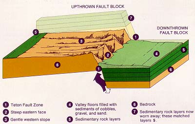
Fault-block mountains are formed by the movement of large crustal blocks when forces in the Earth’s crust pull it apart. Some parts of the Earth are pushed upward and others collapse down.
To understand a fault-block mountain, or sometimes referred as a “fault mountain”, you need to understand what a fault is. Faults are simply cracks in the Earth’s crust. The surface of the Earth can move along these faults, and displace rock layers on either side. Wherever you have movement along the faults, you can get earthquakes, and over long periods of time mountains form under the intense pressure.
Large blocks of rock along the sides of these faults can be uplifted and tilted sideways by this incredible force. And then, on the opposite sides of the faults, the ground tilts downwards forming a depression. This depression gets filled in and leveled by the erosion of the mountains above.
The Sierra Nevada mountains in California are an example of a fault-block mountain range.
We have written many articles about the Earth for Universe Today. Here’s an article that shows how satellites can calculate the movement of the Earth during earthquakes.
Mount Everest from Kalapatthar. Photo: Pavel Novak
[/caption]
One feature of the Earth that you can’t miss are its mountains. But did you know there are different types of mountains? The different mountain types are formed in different ways, through tectonic plates crunching into each other, or sliding past one another, or even from magma coming up out of the Earth. The mountains are different in their appearance, and in their formation. Let’s take a look at each of the major mountain types.
Fold Mountains
The most common type of mountain in the world are called fold mountains. When you see vast mountain ranges stretching on for thousands of kilometers, those are fold mountains. Fold mountains are formed when two of the Earth’s tectonic plates collide head on; like two cars crashing together. The edges of each tectonic plate crumple and buckle, and these create the mountains. Some examples of fold mountain ranges include the Rocky Mountains in North America, and the Himalayan Mountains in Asia.
Fault-Block Mountains
Fault-block mountains (or just “block mountain“) are created when faults or cracks in the Earth’s crust force materials upward. So instead of folding, like the plate collision we get with fold mountains, block mountains break up into chunks and move up or down. Fault-block mountains usually have a steep front side and then a sloping back side. Examples of fault-block mountains include the Sierra Nevada mountains.
Dome Mountains
Dome mountains are created when a large amount of magma pushes up from below the Earth’s crust, but it never actually reaches the surface and erupts. And then, before it can erupt, the source of the magma goes away and the pushed up rock cools and hardens into a dome shape. Since the dome is higher than its surroundings, erosion works from the top creating a circular mountain range.
Volcanic Mountains
Here’s a fairly familiar kind of mountain. Volcanic mountains are created when magma from beneath the Earth makes its way to the surface. When does get the surface, the magma erupts as lava, ash, rock and volcanic gases. This material builds up around the volcanic vent, building up a mountain. Some of the largest mountains in the world were created this way, including Mauna Loa and Mauna Kea on the Big Island of Hawaii. Other familiar volcanoes are Mt. Fuji in Japan and Mt. Rainier in the US.
Plateau Mountains
Plateau mountains are actually formed by the Earth’s internal activity; instead, they’re revealed by erosion. They’re created when running water carves deep channels into a region, creating mountains. Over billions of years, the rivers can cut deep into a plateau and make tall mountains. Plateau mountains are usually found near folded mountains.
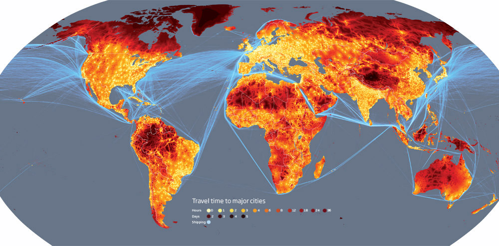
According to a new study, less than 10% of the world’s land is more than 48 hours of travel from the nearest city. This doesn’t include air travel, it is ground-travel only (i.e. on foot, train, car, boat, bike, horse, donkey). So no matter where you are in the world, there’s a good chance you can get to somewhere substantially populated within two days. At face-value, this might not seem very important, but when you look at the maps, you see many wilderness locations aren’t quite as remote as we once thought they were. The Amazon Rainforest for example is surprisingly well connected (rivers are quite useful in that respect), and the remote deserts of Africa have a pretty efficient road network.
So, where is the most remote location on Earth? How long would it take to get there?
I can happily say that for 5 months I lived in one of the most remote places in the world. The Norwegian archipelago of Svalbard in the High Arctic turns out to be a very extreme place even if you put the polar bears and -30°C temperatures to one side. No matter how hard you try, it would take 2-3 days by boat to travel from Longyearbyen (on the main island of Spitsbergen) to the Norwegian mainland city of Tromsø. Unfortunately, the number of places around the globe that can boast this are rapidly shrinking.
The fact is, the travel time of any point from the nearest settlement of over 50,000 people using only ground-travel is decreasing rapidly. Transportation infrastructures are spreading and population density is increasing, meaning more people are making bigger cities closer together.
Travel times as used by the researchersA new set of maps created by researchers at the European Commission’s Joint Research Centre in Ispra, Italy, and the World Bank illustrates just how “connected” our world has become and it also highlights the dwindling number of “true” wildernesses.
Based on a computer model that calculates the journey time to the nearest city of 50,000+ people taking only land or water. The variables included in this complex model are types of terrain, road, rail and river network access, altitude, terrain steepness and obstacles (such as border crossings). The key conclusions the researchers gained are that less than 10% of the planet’s landmass is more than 48 hours ground-travel away from the nearest city. The Amazon, for example, only has 20% of its landmass more than 2 days away from the nearest Brazilian city (owed primarily to its vast network of rivers).
The most striking maps include the plotting of the busiest waterways (the English Channel, Mediterranean and South China Seas are the most crowded) and the scope of the world’s road network. In fact, it is little wonder the international community is worried about the increasing numbers of Somalian pirate attacks; another very busy shipping lane is sandwiched between Somalia and Yemen (the key route from the Indian Ocean to the Mediterranean).
The most remote point on the entire planet: 34.7°N 85.7°E - the Tibetan plateauSo where is the most remote place on Earth? The Tibetan plateau (pictured left). From 34.7°N 85.7°E, it would take three whole weeks to travel to the cities of Lhasa or Korla. If you were to take this trip, expect to walk for 20 days and drive by car for one day. Partly due to the rough terrain and 5200 metres in altitude, Tibet will probably remain the most extreme place on Earth for some time to come.
It is hoped these maps will serve as a baseline for future studies, showing how nations deal with population growth, how nature is being eroded and possibly providing some insight as to how to manage the planet a little better than we are at present…
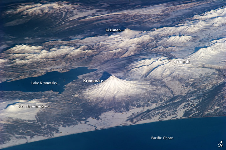
Several volcanoes in Russia, as seen by astronauts on the ISS. Credit: NASA
A volcano is an opening in the Earth’s surface where molten rock can escape from underneath. The Earth’s surface is made up of tectonic plates, which are spreading apart, crunching into each other, or sliding beside one another. Volcanoes are typically found at the fault lines between these plates. There can be active volcanos, which are currently, or have recently erupted. There are also dormant volcanoes, which haven’t erupted recently, and extinct volcanoes, which will never erupt again.
There are 4 major types of volcanoes:
Cinder Cone Volcanoes:
These are the simplest type of volcano. They occur when particles and blobs of lava are ejected from a volcanic vent. The lava is blown violently into the air, and the pieces rain down around the vent. Over time, this builds up a circular or oval-shaped cone, with a bowl-shaped crater at the top. Cinder cone volcanoes rarely grow larger than about 1,000 feet above their surroundings.
Composite Volcanoes:
Composite volcanoes, or stratovolcanoes make up some of the world’s most memorable mountains: Mount Rainier, Mount Fuji, and Mount Cotopaxi, for example. These volcanoes have a conduit system inside them that channels magma from deep within the Earth to the surface. They can have clusters of vents, with lava breaking through walls, or issuing from fissures on the sides of the mountain. With all this material coming out, they can grow thousands of meters tall. As we’ve seen with the famous Mount Saint Helens, composite volcanoes can explode violently.
Shield Volcanoes:
These are large, broad volcanoes that look like shields from above – hence the name. The lava that pours out of shield volcanoes is thin, so it can travel for great distances down the shallow slopes of the volcano. These volcanos build up slowly over time, with hundreds of eruptions, creating many layers. They’re not likely to explode catastrophically. Perhaps the best known shield volcanoes are the ones that make up the Hawaiian Islands, especially Mauna Loa and Mauna Kea.
Lava Domes:
Volcanic or lava domes are created by small masses of lava which are too viscous (thick) to flow very far. Unlike shield volcanoes, with low-viscosity lava, the magma from volcanic domes just pile up over and around the vent. The dome grows by expansion of the lava within, and the mountain forms from material spilling off the sides of the growing dome. Lava domes can explode violently, releasing a huge amount of hot rock and ash.
We have written many articles about volcanoes for Universe Today. Here’s an article about how a volcano sparked lightning storms.
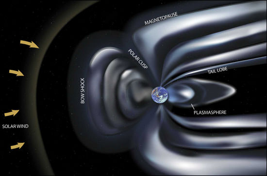
You can’t see it, but there’s an invisible force field around the Earth. Okay, not a force field, exactly, but a gigantic magnetic field surrounding the Earth, and it acts like a force field, protecting the planet – and all the life – from space radiation. Let’s take a look at the Earth’s magnetic field.
The Earth is like a great big magnet. The north pole of the magnet is near the top of the planet, near the geographic north pole, and the south pole is near the geographic south pole. Magnetic field lines extend from these poles for tens of thousands of kilometers into space; this is the Earth’s magneto sphere.
The geographic poles and the magnetic poles are far enough apart that scientists distinguish them differently. If you could draw a line between the magnetic north and south poles, you would get a magnetic axis that’s tilted 11.3 degrees away from the Earth’s axis of rotation. And these magnetic poles are known to move around the surface, wandering as much as 15 km every year.
Scientists think that the Earth’s magnetic field is generated by electrical currents flowing in the liquid outer core deep inside the Earth. Although it’s liquid metal, it moves around through a process called convection. And the movements of metal in the core sets up the currents and magnetic field.
As I mentioned at the top of this article, the magnetic field of the Earth protects the planet from space radiation. The biggest culprit is the Sun’s solar wind. These are highly charged particles blasted out from the Sun like a steady wind. The Earth’s magnetosphere channels the solar wind around the planet, so that it doesn’t impact us. Without the magnetic field, the solar wind would strip away our atmosphere – this is what probably happened to Mars. The Sun also releases enormous amounts of energy and material in coronal mass ejections. These CMEs send a hail of radioactive particles into space. Once again, the Earth’s magnetic field protects us, channeling the particles away from the planet, and sparing us from getting irradiated.
The Earth’s magnetic field reverses itself every 250,000 years or so. The north magnetic pole becomes the south pole, and vice versa. Scientists have no clear theory about why the reversals happen. One interesting note is that we’re long overdue for a reversal. The last one happened about 780,000 years ago.
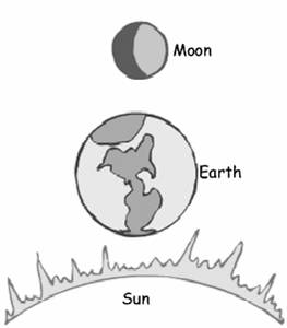
From our perspective, the three objects that have the greatest impact on our lives are the Earth, Sun, and Moon. The Earth, of course, is the planet beneath our feet. Without it, well, we wouldn’t have anything at all. The Sun warms our planet, and with the Moon, creates the tides.
The Moon orbits the Earth and in turn, the Earth orbits the Sun. We see the Universe from a platform that is both rotating on its axis, and traveling in an elliptical orbit around the Sun. The Earth’s rotation on its axis makes the Sun rise in the east and set in the west, and is a big part of why the Moon rises and sets too; although the Moon takes 29 days to complete an orbit around the Earth as well.
The average distance from the Earth to the Moon is 384,403 km. And the average distance from the Earth to the Sun is 149,597,887 km. If you divide these two numbers, you get approximately 389. Now, if you divide the diameter of the Sun (1.4 million km) by the diameter of the Moon (3,474 km), you get 403. Those two numbers are pretty close. This is why the Moon and the Sun appear to be the same size in the sky; it’s a total coincidence.
Because they appear to be the same size in the sky, the Sun, Earth and Moon work together to create eclipses. When the Moon is directly in between the Earth and Sun, we see a solar eclipse. The Moon appears to pass in front of the Sun and darken it completely. And in the opposite situation, when the Earth is in between the Sun and the Moon, the Earth’s shadow darkens the Moon. This is a lunar eclipse. We don’t see eclipses every month because the Moon’s orbit it tilted slightly away from the Earth’s orbit around the Sun. Sometimes the Moon is above this orbit and sometimes it’s below, so it doesn’t block the light from the Sun, or get caught in the Earth’s shadow.
The Sun and the Moon work together to create the tides we experience here on Earth. Most of the rise of the tides comes from the gravitational pull of the Moon, but a small amount comes from the Sun. When the two objects are on the same side of the Earth, we get the highest and lowest tides, and when they’re on opposite sides of the Earth, the tides are less extreme.
The brightest object in the Sky is the Sun. Astronomers measure its apparent magnitude as -26.73. This makes it 449,000 times brighter than the full Moon. The brightness of the Moon is only -12.6. Of course all of the Moon’s brightness is just reflected light from the Sun.
We have written many articles about the Earth for Universe Today. Here’s a more detailed article about the Sun and the Moon.
Science is everywhere in today’s world. It is part of our daily lives, from cooking and gardening, to recycling and comprehending the daily weather report, to reading a map and using a computer. Advances in technology and science are transforming our world at an incredible pace, and our children’s future will surely be filled with leaps in technology we can only imagine. Being “science literate” will no longer be just an advantage but an absolute necessity. We can’t escape from the significance of science in our world.
But not everyone understands that, or has been taught to think critically, or been provided with the tools to analyze and test a problem or situation.
Alom Shaha is a school teacher in the UK, and he has put together a website and a video, asking people to share why science is important. There are scientists, educators, psychologists, artists and many others from different walks of life who participated in this project. The video is of exceptional quality, and I urge everyone to watch and share it. Help people learn about the importance of science.
[/caption]
When I was first asked this question, “who discovered the Earth”, I thought it was ridiculous. If you use your eyes and look down beneath your feet, you’d be able to discover the Earth. This was how the first humans would have done it hundreds of thousands of years ago. But maybe a better question is: who discovered that the Earth is a planet?
In ancient times, people thought the Earth was the center of the Universe, and that the Sun, Moon, planets and stars rotated around us. Although some thought the Earth was flat, the ancient Greeks, like Plato, were convinced that the Earth was a sphere. They thought that each of the worlds and stars were in crystal spheres surrounding us.
This idea is natural and intuitive. Anyone who stands outside and looks up can clearly see that the stars and the planets are turning around the Earth. But ancients astronomers who studied the heavens found a few problems. Instead of following a straight path in the sky, some of the planets would appear to stop, move backwards, stop again, and then move forwards. To explain this, the Greek astronomer Ptolemy said that the planets were in tiny spheres and made little circles as they orbited around the Earth.
It wasn’t until the 16th century that the Polish mathematician and astronomer Nicolaus Copernicus presented the heliocentric model of the Solar System, where the Earth and the other planets orbited around the Sun. His model of the Solar System was backed up by observations by Galileo, who saw that Jupiter had moons of its own, and that Venus went through phases like the Moon.
It took a few years for the ideas to catch on, and for the scientific establishment to agree that yes, the Earth is just another planet, orbiting the Sun, and it’s not the center of the Universe.
We have written many articles about the Earth for Universe Today. Here’s an article about a new telescope that will let you see what Galileo saw.
[/caption]
Take a look down beneath your feet. You’re standing on the Earth’s crust. Although it seems limitless, the Earth’s crust only accounts for less than 1% of the Earth’s interior. Let’s take a look at everything that’s inside the Earth.
The Earth’s crust is the outer shell of the Earth. This is the part that has cooled down enough to solidify into rock. The crust extends down 30 km to 80 km underneath the continents, and only 5 km beneath the oceans. As you travel down through the crust, temperatures increase. The crust is broken up into several tectonic plates which “float” on top of the Earth’s mantle. In some regions, plates are sliding underneath one another, recycling rocks into the Earth. The crust beneath the middle of the oceans is spreading apart, and new material is welling up.
Beneath the crust is the largest part of the Earth’s interior: the mantle, which makes up about 84% of the Earth’s volume. This region extends down to a depth of 2,890 km. As you travel down through the mantle, temperatures increase immensely; they start at 500 C near the crust, and get to well over 4000 C at the boundary to the core. The mantle is mostly solid, but it acts like a viscous fluid, and experiences convection. Hot blobs of rock rise up from regions around the core through the mantle, give up their heat, and then sink back down.
At the very center of the Earth lies the core. This is a solid sphere of metal 2,440 km across surrounded by a layer of liquid metal. Scientists think that mostly made of iron (80%), with the rest composed of other heavy metals, like nickel, gold, platinum and even uranium. The core is slowly rotating compared to the crust, so that the core completes one rotation every 1000 years or so. The Earth’s magnetic field is though to be generated by the convection of hot metal in the Earth’s outer core. This field protects the Earth from the Sun’s solar wind; there probably wouldn’t be life on Earth without this field.
[/caption]
Don’t listen to the Flat Earth Society, they’re wrong; the Earth is round. But did you ever wonder why the Earth is round? It all comes down to gravity.
One of the effects of mass is that it attracts other mass. For small objects, like your computer, your car, and even a building, the force of gravity is tiny. But when you have millions, and even trillions of tonnes of mass, the effect of the gravity really builds up. All of the mass pulls on all the other mass, and it tries to create the most efficient shape… a sphere.
For smaller objects, like asteroids, the force of gravity trying to pull the object into a sphere isn’t enough to overcome the strength of the rock keeping it in shape. But once you get above a certain mass and size, the strength of the object can’t stop the force of gravity from pulling it into a sphere. Objects larger than about 1,000 km in size are able to pull themselves into a sphere.
In fact, the International Astronomical Union decided in 2006 that this ability was one of the requirements for an object to be considered a planet. They must orbit the Sun, they need to have cleared out all the smaller objects in their orbit, and they need to have enough gravity to pull themselves into a sphere.
When an object has the gravity to pull itself into a sphere, astronomers say that it’s in hydrostatic equilibrium. And that’s why the Earth is round.
Of course, the Earth isn’t perfectly round. Because it’s turning on its axis approximately once every 24 hours, the Earth’s equator bulges outwards. And there are mountains and valleys that make the Earth’s surface rough.
We have written many articles about the Earth for Universe Today. Here’s an article about how round the Earth really is.
We have also recorded an episode of Astronomy Cast about Earth, answering a few questions, like why is Earth round. This was part of our tour through the Solar System – Episode 51: Earth.


