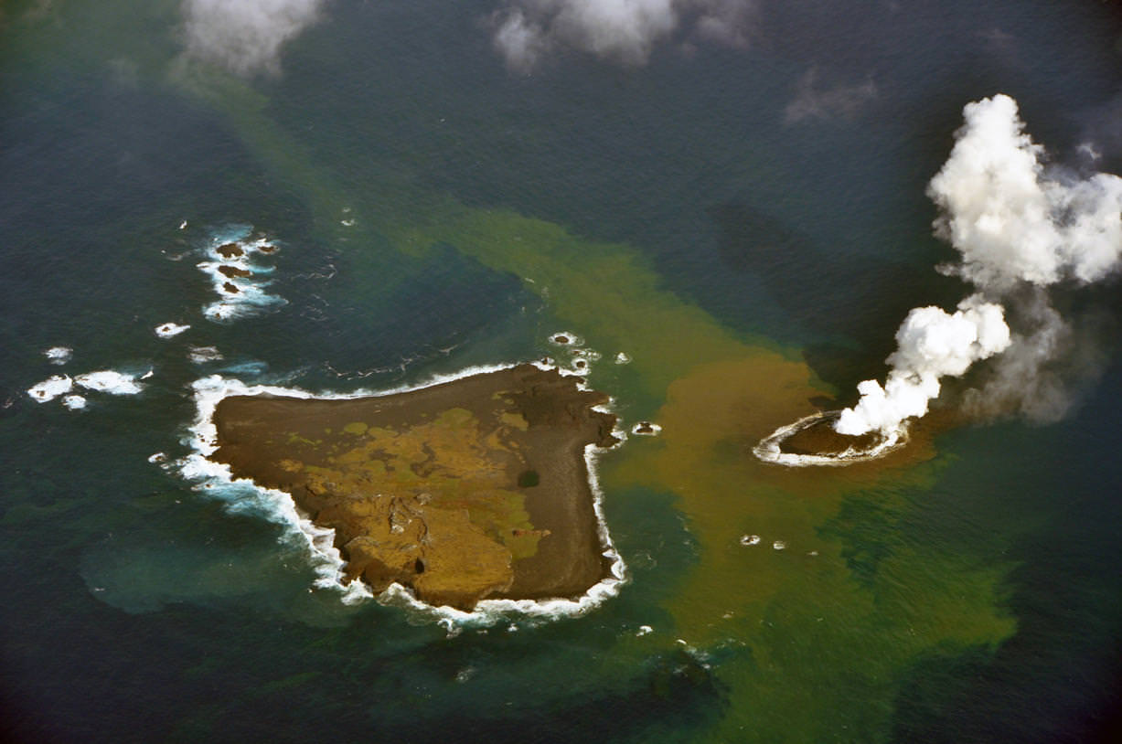
An erupting undersea volcano forms a new island off the coast of Nishinoshima, a small unihabited island in the southern Ogasawara chain of islands. The image was taken on November 21, 2013 by the Japanese Coast Guard.
A volcanic eruption is creating a tiny new island off the coast of Japan. The Japanese Coast Guard snapped images and video of the eruption taking place, showing the new island being formed. Footage showed heavy smoke, ash and rocks spewing from the volcanic crater. As of this writing, experts say the small island is about 200 meters (660 feet) in diameter. It is located just off the coast of Nishinoshima, a small, uninhabited island in the Ogasawara chain, also known as the Bonin Islands, about about 620 miles (1,000 km) south of Tokyo.
See a video and additional images below.
Only time will tell if the island will remain or if the ocean waters will reclaim it. According to Yahoo News, Japan’s chief government spokesman said they would welcome any new territory.
“This has happened before and in some cases the islands disappeared,” Yoshihide Suga said when asked if the government was planning on naming the new island. “If it becomes a full-fledged island, we would be happy to have more territory.”
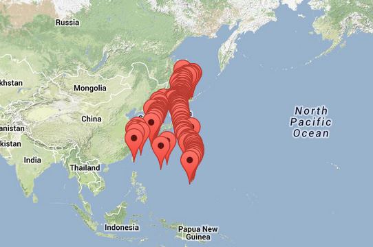
An erupting undersea volcano forms a new island, shown by its nearest neighbor, Nishinoshima, a small unihabited island in the southern Ogasawara chain of islands. The image was taken on November 21, 2013 by the Japanese Coast Guard.This screenshot of Google Maps shows all the volcanoes in the The Japan, Taiwan, Marianas Region. Via Google Maps and the Smithsonian volcano website.
According to the Smithsonian Global Volcanism Program website, the Japan, Taiwan, Marianas Region is a very active region in the Pacific Ring of Fire and most volcanoes in this region “result from subduction of westward-moving oceanic crust under the Asian Plate. In the Izu-Mariana chain, however, the crust to the west is also oceanic, forming more basaltic island arcs (but with volcanoes that are far more explosive than oceanic hotspot volcanoes).”
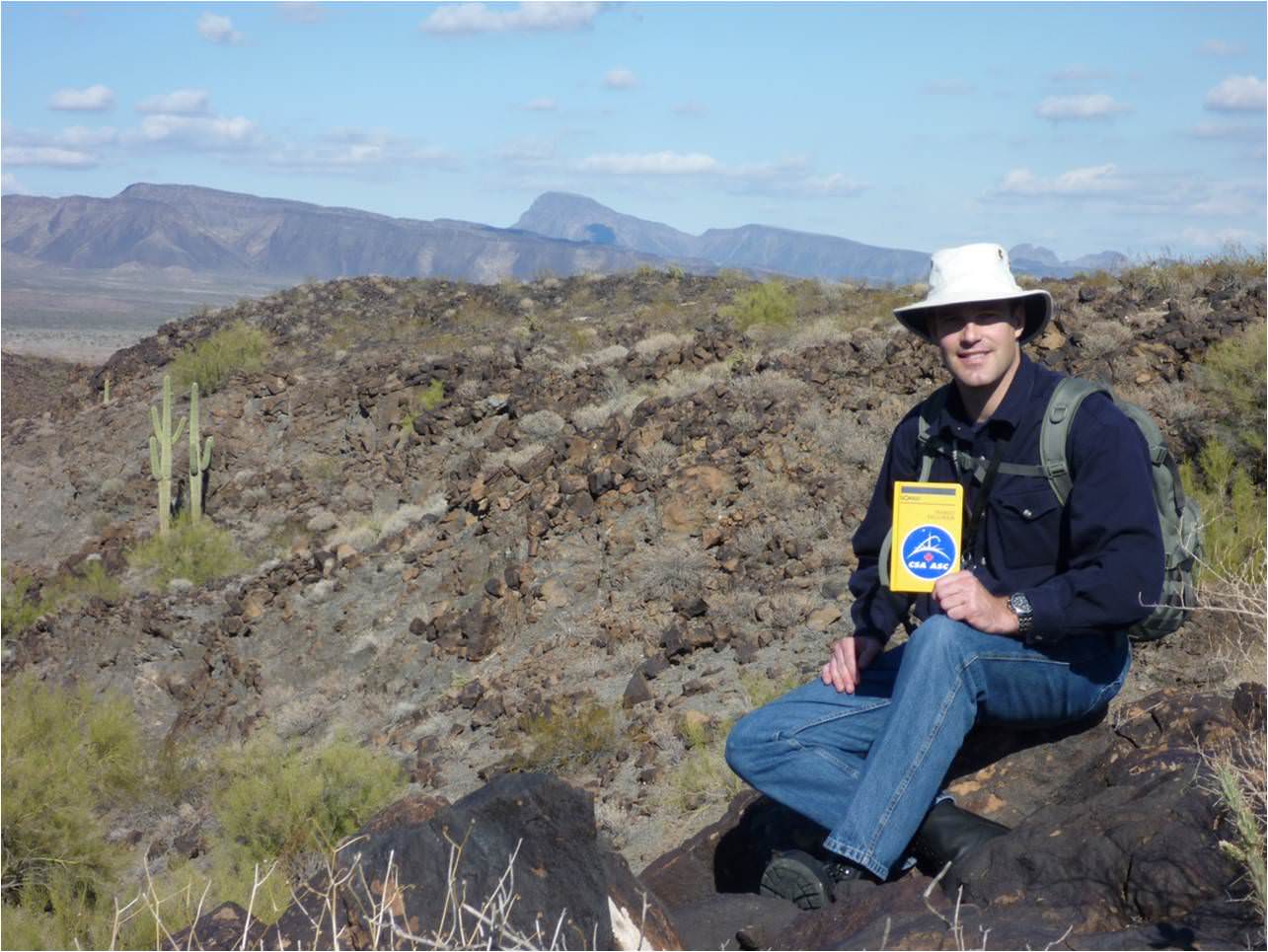
Canadian astronaut Jeremy Hansen during 2010 geology training near Gila Bend, Arizona. Credit: Canadian Space Agency
This week, Canadian astronaut Jeremy Hansen is on his way to a remote island in the Canadian Arctic. We realize this sounds like the opening episode for Survivor, but his purpose up there is more scientific: to conduct field geology.
Geology work, and training for sample collection is not as easy as simply picking up whatever you see on the ground. It’s important to get a range of rocks that represent the geology of the area. You also need to photograph and otherwise document the area in such a way that geologists can learn more about how it was formed, among other duties.
A trained observer can come to preliminary conclusions while wandering around in the field, and possibly change his or her sample-gathering strategy in accordance with that. The Apollo moon missions were replete with examples of this, with one of the more famous ones perhaps being when Harrison Schmitt (who, unlike his colleagues, had a Ph.D. in geology) stumbled across some orange soil during Apollo 17. This was probably evidence of an ancient fire-fountain of lava on the moon.
But Schmitt certainly wasn’t expecting to see that when he walked on the surface. Check out his reaction around 1:50 in this video:
Hansen will join a Western University group to study “impact cratering processes while learning methods and techniques for conducting geological fieldwork that can be applied to sites beyond our planet,” stated the Canadian Space Agency. To make it feel more space mission-like, the group will be working with limited supplies and support.
Geology training isn’t important just on the ground, but also in observing from space. As Hansen points out on this video, from time to time astronauts on the International Space Station are called upon to observe features from their orbital perches. If they understand the processes behind what they see, their descriptions, videos and photos will be more scientific.
Hansen will stay on Devon Island until about July 25, studying impact crater processes along with the rest of the team. Updates should be available on his Twitter feed as well as through the Canadian Space Agency.
And by the way, Canada was also useful to astronauts during the Apollo years. One famous geology site was at Sudbury, Ont. This website highlights the activities of the Apollo 16 crew, which was looking at craters in the area.
This article comes from the Universe Today archive, but was updated with this spiffy video.
How old is the Earth? Scientists think that the Earth is 4.54 billion years old. Coincidentally, this is the same age as the rest of the planets in the Solar System, as well as the Sun. Of course, it’s not a coincidence; the Sun and the planets all formed together from a diffuse cloud of hydrogen billions of years ago.
In the early Solar System, all of the planets formed in the solar nebula; the remnants left over from the formation of the Sun. Small particles of dust collected together into larger and larger objects – pebbles, rocks, boulders, etc – until there were many planetoids in the Solar System. These planetoids collided together and eventually enough came together to become Earth-sized.
At some point in the early history of Earth, a planetoid the size of Mars crashed into our planet. The resulting collision sent debris into orbit that eventually became the Moon.
How do scientists know Earth is 4.54 billion years old? It’s actually difficult to tell from the surface of the planet alone, since plate tectonics constantly reshape its surface. Older parts of the surface slide under newer plates to be recycled in the Earth’s core. The oldest rocks ever found on Earth are 4.0 – 4.2 billion years old.
Scientists assume that all the material in the Solar System formed at the same time. Various chemicals, and specifically radioactive isotopes were formed together. Since they decay in a very known rate, these isotopes can be measured to determine how long the elements have existed. And by studying different meteorites from different locations in the Solar System, scientists know that the different planets all formed at the same time.
Failed Methods for Calculating the Age of the Earth
Our current, accurate method of measuring the age of the Earth comes at the end of a long series of estimates made through history. Clever scientists discovered features about the Earth and the Sun that change over time, and then calculated how old the planet Earth is from that. Unfortunately, they were all flawed for various reasons.
Declining Sea Levels – Benoit de Maillet, a French anthropologist who lived from 1656-1738 and guessed (incorrectly) that fossils at high elevations meant Earth was once covered by a large ocean. This ocean had taken 2 billion years to evaporate to current sea levels. Scientists abandoned this when they realized that sea levels naturally rise and fall.
Cooling of the Earth – William Thompson, later known as Lord Kelvin, assumed that the Earth was once a molten ball of rock with the same temperature of the Sun, and then has been cooling ever since. Based on these assumptions, Thompson calculated that the Earth took somewhere between 20 and 400 million years to cool to its current temperature. Of course, Thompson made several inaccurate assumptions, about the temperature of the Sun (it’s really 15 million degrees Kelvin at its core), the temperature of the Earth (with its molten core) and how the Sun is made of hydrogen and the Earth is made of rock and metal.
Cooling of the Sun – In 1856, the German physicist Hermann Ludwig Ferdinand von Helmholtz attempted to calculate the age of the Earth by the cooling of the Sun. He calculated that the Sun would have taken 22 million years to condense down to its current diameter and temperature from a diffuse cloud of gas and dust. Although this was inaccurate, Helmholtz correctly identified that the source of the Sun’s heat was driven by gravitational contraction.
Rock Erosion – In his book, The Origin of Species by Means of Natural Selection, Charles Darwin proposed that the erosion of chalk deposits might allow for a calculation of the minimum age of the planet. Darwin estimated that a chalk formation in the Weald region of England might have taken 300 million years to weather to its current form.
Orbit of the Moon – George Darwin, the son of Charles Darwin, guessed that the Moon might have been formed out of the Earth, and drifted out to its current location. The fission theory proposed that the Earth’s rapid rotation caused a chunk of the planet to spin off into space. Darwin calculated that it had taken the Moon at least 56 million years to reach its current distance from Earth. We now know the Moon was probably formed when a Mars-sized object smashed into the Earth billions of years ago.
Salinity of the Ocean – In 1715, the famous astronomer Edmund Halley proposed that the salinity of the oceans could be used to estimate the age of the planet. Halley observed that oceans and lakes fed by streams were constantly receiving more salt, which then stuck around as the water evaporated. Over time, the water would be come saltier and saltier, allowing an estimate of how long this process has been going on. Various geologists used this method to guess that the Earth was between 80 and 150 million years old. This method was flawed because scientists didn’t realize that geologic processes are extracting salt out of the water as well.
Radiometric Dating Provides an Accurate Method to Know the Age of the Earth
In 1896, the French chemist A. Henri Becquerel discovered radioactivity, the process where materials decay into other materials, releasing energy. Geologists realized that the interior of the Earth contained a large amount of radioactive material, and this would be throwing off their calculations for the age of the Earth. Although this discovery revealed flaws in the previous methods of calculating the age of the Earth, it provided a new method: radiometric dating.
Geologists discovered that radioactive materials decay into other elements at a very predictable rate. Some materials decay quickly, while others can take millions or even billions of years to fully decay. Ernest Rutherford and Frederick Soddy, working at McGill University, determined that half of any isotope of a radioactive element decays into another isotope at a set rate. For example, if you have a set amount of Thorium-232, half of it will decay over a billion years, and then half of that amount will decay in another billion years. This is the source of the term “half life”.
By measuring the half lives of radioactive isotopes, geologists were able to build a measurement ladder that let them accurately calculate the age of geologic formations, including the Earth. They used the decay of uranium into various isotopes of lead. By measuring the amount of three different isotopes of lead (Pb-206, Pb-207, and Pb-208 or Pb-204), geologists can calculate how much Uranium was originally in a sample of material.
If the Solar System formed from a common pool of matter, with uniformly distributed Pb isotopes, then all objects from that pool of matter should show similar amounts of the isotopes. Also, over time, the amounts of Pb-206 and Pb-207 will change because as these isotopes are end-products of uranium decay. This makes the amount of lead and uranium change. The higher the uranium-to-lead ratio of a rock, the more the Pb-206/Pb-204 and Pb-207/Pb-204 values will change with time. Now, supposing that the source of the Solar system was also uniformly distributed with uranium isotopes, then you can draw a data line showing a lead-to-uranium plot and, from the slope of the line, the amount of time which has passed since the pool of matter became separated into individual objects can be computed.
Bertram Boltwood applied this method of dating to 26 different samples of rocks, and discovered that they had been formed between 92 and 570 million years old, and further refinements to the technique gave ages between 250 million to 1.3 billion years.
Geologists set about exploring the Earth, seeking the oldest rock formations on the planet. The oldest surface rock is found in Canada, Australia and Africa, with ages ranging from 2.5 to 3.8 billion years. The very oldest rock was discovered in Canada in 1999, and estimated to be just over 4 billion years old.
This set a minimum age for the Earth, but thanks to geologic processes like weathering and plate tectonics, it could still be older.
Meteorites as the Final Answer to the Age of the Earth
The problem with measuring the age of rocks on Earth is that the planet is under constant geological change. Plate tectonics constantly recycle portions of the Earth, blending it up and forever hiding the oldest regions of the planet. But assuming that everything in the Solar System formed at the same time, meteorites in space have been unaffected by weathering and plate tectonics here on Earth.
Geologists used these pristine objects, such as the Canyon Diablo meteorite (the fragments of the asteroid that impacted at Barringer Crater) as a way to get at the true age of the Solar System, and therefore the Earth. By using the radiometric dating system on these meteorites, geologists have been able to determine that the Earth is 4.54 billion years old within a margin of error of about 1%.
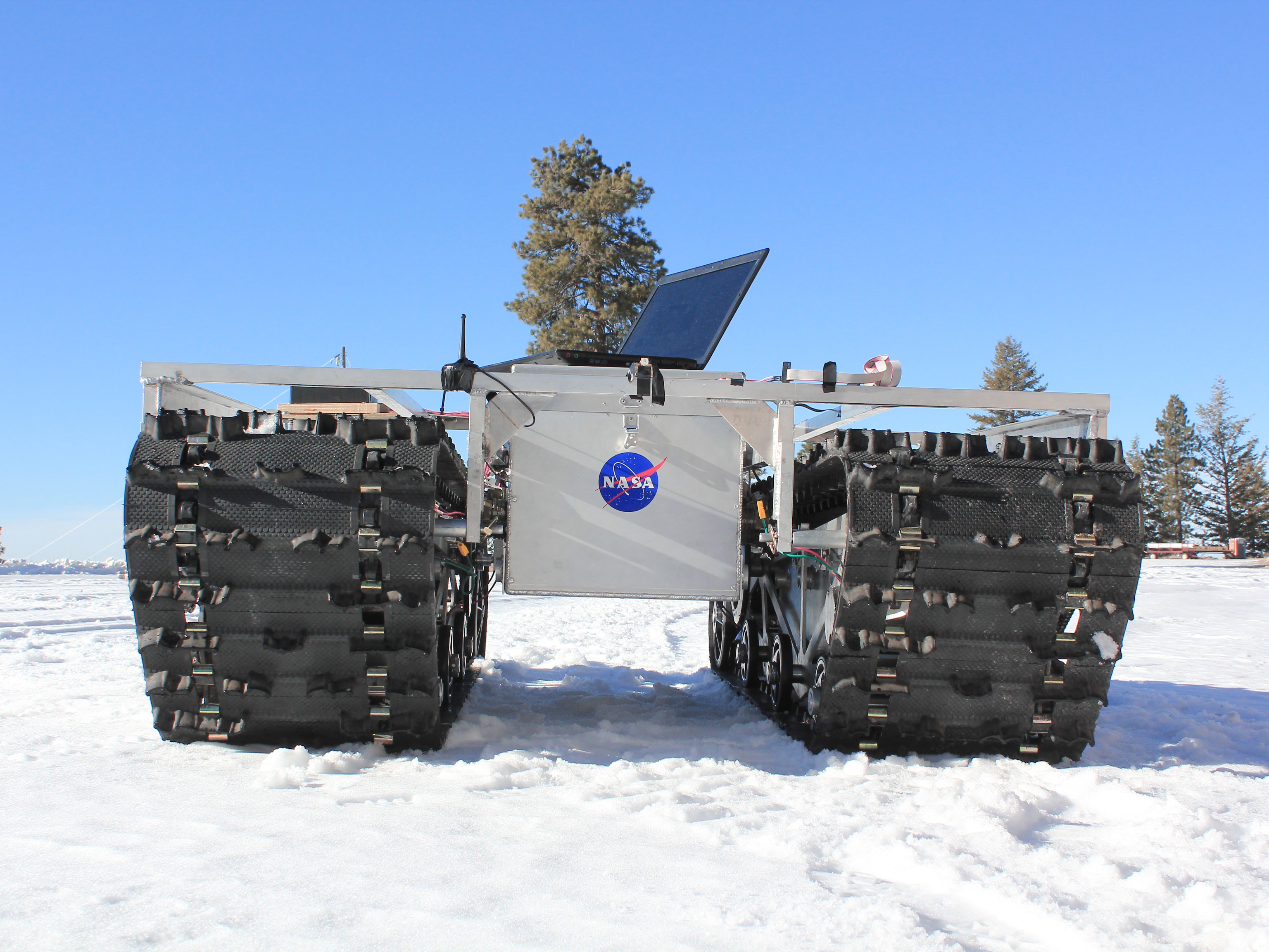
A GROVER prototype during testing in January 2013. Credit: Gabriel Trisca, Boise State University
How fast is Greenland’s ice sheet melting in response to climate change, and how is it recovering? A new NASA rover with the friendly name of GROVER (Greeland Rover and Goddard Remotely Operated Vehicle for Exploration and Research) is going to try to figure that out.
GROVER will rove across a small area of the massive ice sheet at a location called Summit Camp, which is a National Science Foundation outpost. On board it has ground-penetrating radar that is intended to figure out how the snow builds up in layers through time.
“Robots like GROVER will give us a new tool for glaciology studies,” stated Lora Koenig, a glaciologist at Goddard and science advisor on the project.
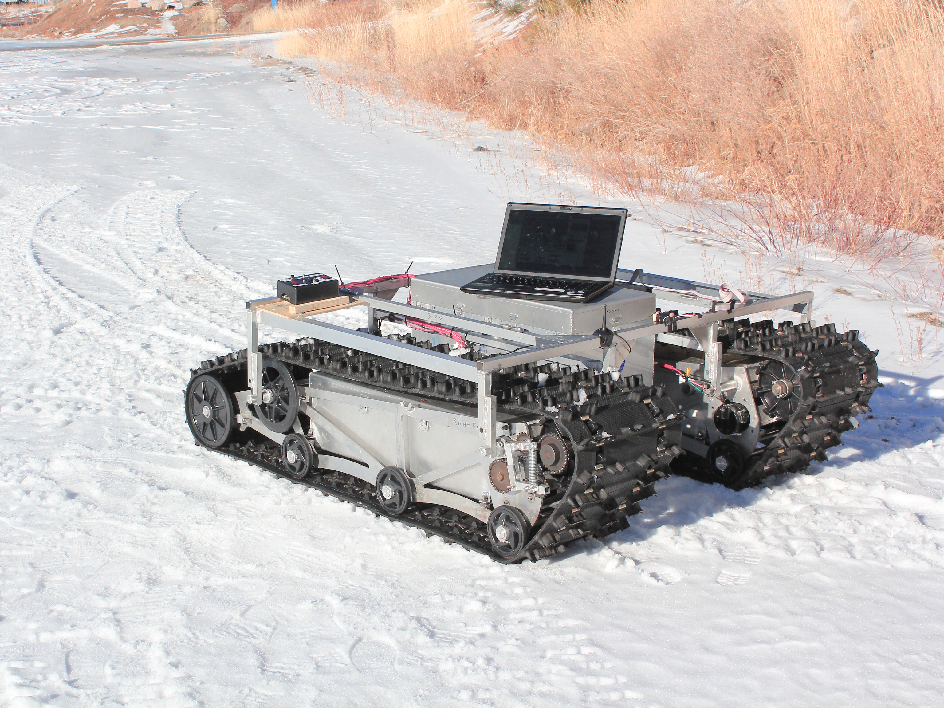
A prototype of GROVER during testing in January 2012. The rover does not have its solar panels attached here. The laptop was used as part of that specific test only. Credit: Gabriel Trisca, Boise State University
The student-designed project came to be during development phases in 2010 and 2011, principally at Boise State University in Idaho. At six feet tall, it’s way more massive than its Sesame Street namesake: it tips the scale at 800 pounds, including solar panels, and has two snowmobile tracks built in to move around.
“GROVER is just like a spacecraft but it has to operate on the ground,” stated Michael Comberiate, a retired NASA engineer and manager of Goddard’s Engineering Boot Camp.
“It has to survive unattended for months in a hostile environment, with just a few commands to interrogate it and find out its status and give it some directions for how to accommodate situations it finds itself in.”
Studies began on May 3 and will continue through June 8.
When the Moon was receiving its highest number of impacts, so was Earth. Credit: Dan Durda
Some questions about our own planet are best answered by looking someplace else entirely… in the case of impact craters and when, how and how often they were formed, that someplace can be found shining down on us nearly every night: our own companion in space, the Moon.
By studying lunar impact craters both young and old scientists can piece together the physical processes that took place during the violent moments of their creation, as well as determine how often Earth — a considerably bigger target — was experiencing similar events (and likely in much larger numbers as well.)
With no substantial atmosphere, no weather and no tectonic activity, the surface of the Moon is a veritable time capsule for events taking place in our region of the Solar System. While our constantly-evolving Earth tends to hide its past, the Moon gives up its secrets much more readily… which is why present and future lunar missions are so important to science.
Take the crater Linné, for example. A young, pristine lunar crater, the 2.2-km-wide Linné was formed less than 10 million years ago… much longer than humans have walked the Earth, yes, but very recently on lunar geologic terms.
It was once thought that the circular Linné (as well as other craters) is bowl-shaped, thus setting a precedent for the morphology of craters on the Moon and on Earth. But laser-mapping observations by NASA’s Lunar Reconnaissance Orbiter (at right) determined in early 2012 that that’s not the case; Linné is actually more of a truncated inverted cone, with a flattened interior floor surrounded by sloping walls that rise up over half a kilometer to its rim.
On our planet the erosive processes of wind, water, and earth soon distort the shapes of craters like Linné, wearing them down, filling them in and eventually hiding them from plain sight completely. But in the Moon’s airless environment where the only weathering comes from more impacts they retain their shape for much longer lengths of time, looking brand-new for many millions of years. By studying young craters in greater detail scientists are now able to better figure out just what happens when large objects strike the surface of worlds — events that can and do occur quite regularly in the Solar System, and which may have even allowed life to gain a foothold on Earth.
Most of the craters visible on the Moon today — Linné excluded, of course — are thought to have formed within a narrow period of time between 3.8 and 3.9 billion years ago. This period, called the Late Heavy Bombardment, saw a high rate of impact events throughout the inner Solar System, not only on the Moon but also on Mars, Mercury, presumably Venus and Earth as well. In fact, since at 4 times its diameter the Earth is a much larger target than the Moon, it stands to reason that Earth was impacted many more times than the Moon as well. Such large amounts of impacts introduced material from the outer Solar System to the early Earth as well as melted areas of the surface, releasing compounds like water that had been locked up in the crust… and even creating the sorts of environments where life could have begun to develop and thrive.
(It’s been suggested that there was even a longer period of heavy impact rates nicknamed the “late late heavy bombardment” that lingered up until about 2.5 billion years ago. Read more here.)
In the video below lunar geologist David Kring discusses the importance of impacts on the evolution of the Moon, Earth and eventually life as we know it today:
“Impact cratering in Earth’s past has affected not only the geologic but the biologic evolution of our planet, and we were able to deduce that in part by the lessons we learned by studying the Moon… and you just have to wonder what other things we can learn by going back to the Moon and studying that planetary body further.”
It’s these sorts of connections that make lunar exploration so valuable. Keys to our planet’s past are literally sitting on the surface of the Moon, a mere 385,000 km away, waiting for us to just scoop them up and bring them back. While the hunt for a biological history on Mars or resource-mining an asteroid are definitely important goals in their own right, only the Moon holds such direct references to Earth. It’s like an orbiting index to the ongoing story of our planet — all we have to do is make the connections.
Learn more about lunar research at the LPI site here, and see the latest news and images from LRO here.
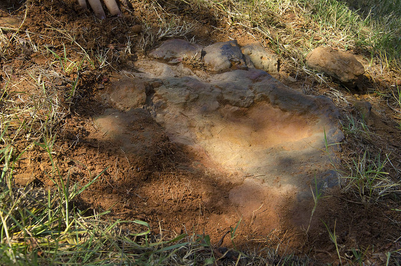
Fossilized nodosaur footprints discovered at NASA’s Goddard Space Flight Center in Maryland. (NASA/GSFC/Rebecca Roth)
At NASA’s Goddard Space Flight Center in Greenbelt, MD, where some of the world’s most advanced research in space technology is being performed on a daily basis, paleontologists have discovered ancient evidence of dinosaurs on the Center’s wooded campus — at least two, possibly a mother and child, crossed that way between 112 and 110 million years ago and left their muddy footprints as proof.
The tracks of two nodosaurs — short, stocky and heavily-armored herbivorous dinosaurs — have been confirmed by dinosaur tracker Ray Stanford and USGS emeritus paleontologist Dr. Robert Weems. The second track is a smaller version of the first.
The first, larger footprint was announced by Stanford on August 17. When Dr. Weems was called in to verify, the smaller print was discovered within the first, evidence that they were made around the same time and leading researchers to suggest it may have been a mother-and-child pair.
Dinosaur tracker Ray Stanford describes the cretaceous-era nodosaur track he found on the Goddard Space Flight Center campus with Dr. Robert Weems, emeritus paleontologist for the USGS who verified his discovery. (NASA/GSFC/Rebecca Roth)
“It looks to be a manus (front foot) print of a much smaller dinosaur than the first one, but it looks to be the same type,” Weems said of the second track. “If the one that came through was a female, it may have had one or more young ones following along. If you’ve seen a dog or cat walking with its young, they kind of sniff around and may not go in the same direction, but they end up in the same place.”
It’s thought that the nodosaurs were moving quickly since the tracks don’t show strong imprints of the animals’ heels. Still, the ruddy Cretaceous-era mud preserved their brief passage well — even as millions of years went by.
“This was a large, armored dinosaur,” Stanford said. “Think of it as a four-footed tank. It was quite heavy, there’s a quite a ridge or push-up here. Subsequently the sand was bound together by iron-oxide or hematite, so it gave us a nice preservation, almost like concrete.”
The next steps will be to have the site analyzed to determine whether further excavation is called for, and possibly to extract and preserve the existing footprints.
“Space scientists may walk along here, and they’re walking exactly where this big, bungling heavy armored dinosaur walked, maybe 110 to 112 million years ago.”
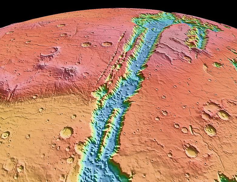
Valles Marineris NASA World Wind map Mars Credit NASA
Caption: Valles Marineris NASA World Wind Map Mars Credit: NASA
Until now, Earth was thought to be the only planet with plate tectonics. But a huge “crack” in Mars’ surface — the massive Valles Marinaris — shows evidence of the movement of huge crustal plates beneath the planet’s surface, meaning Mars may be showing the early stages of plate tectonics. This discovery can perhaps also shed light on how the plate tectonics process began here on Earth.
Valles Marineris is no ordinary crack on the Martian surface. It is the longest and deepest system of canyons in the Solar System. Stretching nearly 2,500 miles, it is nine times longer than Earth’s Grand Canyon.
An Yin, a planetary geologist and UCLA professor of Earth and space sciences, analyzed satellite images from THEMIS (Thermal Emission Imaging System), on board the Mars Odyssey spacecraft, and from the HIRISE (High Resolution Imaging Science Experiment) camera on NASA’s Mars Reconnaissance Orbiter.
“When I studied the satellite images from Mars, many of the features looked very much like fault systems I have seen in the Himalayas and Tibet, and in California as well, including the geomorphology,” he said.
The two plates that Yin calls Valles Marineris North and Valles Marineris South are moving approximately 93 miles horizontally relative to each other. By comparison, California’s San Andreas Fault, which is similarly over the intersection of two plates, has moved about twice as much, because Earth is about twice the size of Mars.
Yin believes Mars has no more than two plates whereas Earth has seven major plates and dozens of smaller ones. As Yin puts it “Earth has a very broken ‘egg shell,’ so its surface has many plates; Mars’ is slightly broken and may be on the way to becoming very broken, except its pace is very slow due to its small size and, thus, less thermal energy to drive it. This may be the reason Mars has fewer plates than on Earth.”
Mars also has several long, straight chains of volcanoes, including three that make up the Tharsis Montes, three large shield volcanoes which includes Olympus Mons, the tallest mountain in the Solar System at 22 km high. These volcanic chains may have formed from the motion of a plate sitting over a “hot spot” in the Martian mantle, in the same way the Hawaiian Islands are thought to have formed here on Earth. Yin also identified a steep cliff similar to cliffs in California’s Death Valley, which are generated by a fault, as well as a very smooth and flat side of a canyon wall which Yin says is also strong evidence of tectonic activity.
Yin also suggests that the fault is shifting occasionally, and may even produce “Marsquakes” every now and again. “I think the fault is probably still active, but not every day. It wakes up every once in a while, over a very long duration — perhaps every million years or more,” he said.
It is not known how far beneath the surface the plates on Mars are located. Yin admits “I don’t quite understand why the plates are moving with such a large magnitude or what the rate of movement is; maybe Mars has a different form of plate tectonics,” Yin said. “The rate is much slower than on Earth.”
“Mars is at a primitive stage of plate tectonics,” Yin added. “It gives us a glimpse of how the early Earth may have looked and may help us understand how plate tectonics began on Earth.”
Yin’s study was published in the August issue of the journal Lithosphere and he also plans to publish a follow-up paper hoping to shed more light on plate tectonics on both Mars and Earth.
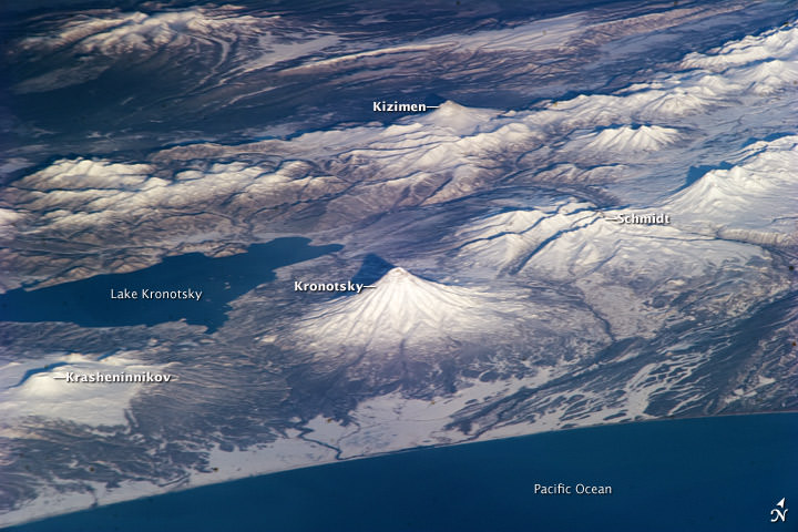
Several volcanoes in Russia, as seen by astronauts on the ISS. Credit: NASA
A volcano is an opening in the Earth’s surface where molten rock can escape from underneath. The Earth’s surface is made up of tectonic plates, which are spreading apart, crunching into each other, or sliding beside one another. Volcanoes are typically found at the fault lines between these plates. There can be active volcanos, which are currently, or have recently erupted. There are also dormant volcanoes, which haven’t erupted recently, and extinct volcanoes, which will never erupt again.
There are 4 major types of volcanoes:
Cinder Cone Volcanoes:
These are the simplest type of volcano. They occur when particles and blobs of lava are ejected from a volcanic vent. The lava is blown violently into the air, and the pieces rain down around the vent. Over time, this builds up a circular or oval-shaped cone, with a bowl-shaped crater at the top. Cinder cone volcanoes rarely grow larger than about 1,000 feet above their surroundings.
Composite Volcanoes:
Composite volcanoes, or stratovolcanoes make up some of the world’s most memorable mountains: Mount Rainier, Mount Fuji, and Mount Cotopaxi, for example. These volcanoes have a conduit system inside them that channels magma from deep within the Earth to the surface. They can have clusters of vents, with lava breaking through walls, or issuing from fissures on the sides of the mountain. With all this material coming out, they can grow thousands of meters tall. As we’ve seen with the famous Mount Saint Helens, composite volcanoes can explode violently.
Shield Volcanoes:
These are large, broad volcanoes that look like shields from above – hence the name. The lava that pours out of shield volcanoes is thin, so it can travel for great distances down the shallow slopes of the volcano. These volcanos build up slowly over time, with hundreds of eruptions, creating many layers. They’re not likely to explode catastrophically. Perhaps the best known shield volcanoes are the ones that make up the Hawaiian Islands, especially Mauna Loa and Mauna Kea.
Lava Domes:
Volcanic or lava domes are created by small masses of lava which are too viscous (thick) to flow very far. Unlike shield volcanoes, with low-viscosity lava, the magma from volcanic domes just pile up over and around the vent. The dome grows by expansion of the lava within, and the mountain forms from material spilling off the sides of the growing dome. Lava domes can explode violently, releasing a huge amount of hot rock and ash.
We have written many articles about volcanoes for Universe Today. Here’s an article about how a volcano sparked lightning storms.


 William Thompson, later known as Lord Kelvin, assumed that the Earth was once a molten ball of rock with the same temperature of the Sun, and then has been cooling ever since. Based on these assumptions, Thompson calculated that the Earth took somewhere between 20 and 400 million years to cool to its current temperature. Of course, Thompson made several inaccurate assumptions, about the temperature of the Sun (it’s really 15 million degrees Kelvin at its core), the temperature of the Earth (with its molten core) and how the Sun is made of hydrogen and the Earth is made of rock and metal.