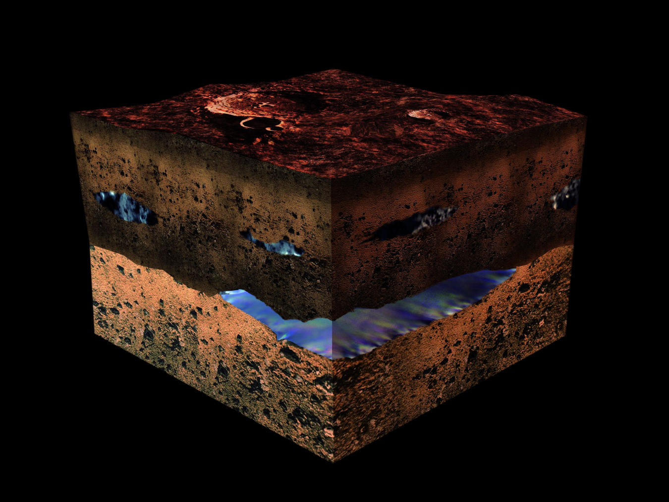
Artist's impression of water under the Martian surface. Credit: ESA/Medialab
The possibility that life could exist on Mars has captured the imagination of researchers, scientists and writers for over a century. Ever since Giovanni Schiaparelli (and later, Percival Lowell) spotted what they believed were “Martian Canals” in the 19th century, humans have dreamed of one day sending emissaries to the Red Planet in the hopes of finding a civilization and meeting the native Martians.
While the Mariner and Viking programs of the 1960s and 70s shattered the notion of a Martian civilization, multiple lines of evidence have since emerged that indicate how life could have once existed on Mars. Thanks to a new study, which indicates that Mars may have enough oxygen gas locked away beneath its surface to support aerobic organisms, the theory that life could still exist there has been given another boost.
This 360-degree panorama was taken on Aug. 9 by NASA's Curiosity rover at its location on Vera Rubin Ridge. Credit: NASA/JPL-Caltech/MSSS
Ever since it landed on the Red Planet in 2012, the Curiosity rover has showed no signs of slowing down! For the past six years, it has ventured across the Gale Crater, scaled Mount Sharp, and taken numerous drill samples. And in the process, it has found evidence that liquid water (and possibly even life) once existed on the Martian surface.
It has also taken many breathtaking pictures that have catalogued its progress. Last month (on Aug. 9th), the rover took another 360-degree panoramic photo of its location. In addition to showing how the skies were still darkened by the fading dust storm and the rover’s dust-covered body, the picture also captured and the site where the latest drill sample was obtained.
This low-angle self-portrait of NASA's Curiosity Mars rover shows the vehicle at the site from which it reached down to drill into a rock target called "Buckskin" on lower Mount Sharp. Credits: NASA/JPL-Caltech/MSSS
Martian dust storms, which occur during the summer season in the planet’s southern hemisphere, can get pretty intense. Over the course of the past few weeks, a global dust storm has engulfed Mars and forced the Opportunity rover to suspend operations. Given that this storm is much like the one that took place back in 2007, which also raged for weeks, there have been concerns over how this development could affect rover operations.
Meanwhile the Curiosity rover managed to snap pictures of the thickening haze caused by the storm. Though Curiosity is on the other side of the planet from where Opportunity is currently located, atmospheric dust has been gradually increasing over it. But unlike Opportunity, which runs on solar power, Curiosity will remain unaffected by the global storm thanks to its nuclear-powered battery, and is therefore in a good position to study it.
As already noted, Martian storms occur during summer in the southern hemisphere, when sunlight warms dust particles and lifts them higher into the atmosphere, creating more wind. The resulting wind kicks up yet more dust, creating a feedback loop that NASA scientists are still trying to understand. Since the southern polar region is pointed towards the Sun in the summer, carbon dioxide frozen in the polar cap evaporates.
Global map of Mars produced by the Mars Color Imager (MARCI) camera on NASA’s Mars Reconnaissance Orbiter (MRO), which shows a growing dust storm as of June 6th, 2018. The blue dot indicates the approximate location of Opportunity. Credit: NASA/JPL-Caltech/MSSS
This has the effect of thickening the atmosphere and increasing the surface pressure, which enhances the process by helping suspend dust particles in the air. In some cases, the dust clouds can reach up to 60 km (40 mi) or more in elevation. Though they are common and can begin suddenly, Martian dust storms typically stay contained to a local area and last only about a weeks.
By contrast, the current storm has lasted for several weeks and is currently covering an area that would span North America and Russia combined. While smaller than the storm that took place back in 2007, this storm has intensified to the point where it created a perpetual state of night over the rover’s location in Perseverance Valley and led to a level of atmospheric opacity that is much worse than the 2007 storm.
When dust storms occur, scientists measure them based on their opacity level (tau) to determine how much sunlight they will prevent from reaching the surface. Whereas the 2007 storm had a tau level of about 5.5, this most recent storm reached an estimated tau of 10.8 earlier this month over the Perseverance Valley – where Opportunity is located.
The intensity of the storm also led Bruce Canton, deputy principal investigator of the Mars Color Imager (MARCI) camera onboard NASA’s Mars Reconnaissance Orbiter (MRO), to declare that the storm has officially become a “planet-encircling” (or “global”) dust event. Above the Gale Crater, where Curiosity is located, the tau reading is now above 8.0 – the highest ever recorded by the mission.
In June 2018 NASA’s Curiosity Rover used its Mast Camera, or Mastcam, to snap photos of the intensifying haziness the surface of Mars, caused by a massive dust storm. The photos span about a couple of weeks, starting with a shot of the area before the storm appeared. Credits: NASA
While the storm has some worried about the fate of Opportunity, which is Mars’ oldest active rover (having remained in operation for over 14 years), it is also an chance to address one of the greatest questions scientists have about Mars. For example, why do some storms span the entire planet and last for months while others are confined to small areas and and last only a week?
The animation (shown above) consists of a series of daily photos captures by Curiosity’s Mast Camera (Mastcam), which show the sky getting hazier over time. While taking these pictures, Curiosity was facing the crater rim, about 30 km (18.6) away from where it stands inside the crater. This sun-obstructing wall of haze is about six to eight times thicker than normal for this time of season.
Nevertheless, Curiosity’s engineers – which are based at NASA’s Jet Propulsion Laboratory in Pasadena, California – have studied how the growing dust storm could affect the rover’s instruments and concluded that it poses little risk. Ironically enough, the largest impact will be on the rover’s cameras, which require extra exposure time due to the low lighting conditions.
Two images from the Mast Camera (Mastcam) on NASA’s Curiosity rover depicting the change in the color of light illuminating the Martian surface since a dust storm engulfed Gale Crater. Credits: NASA/JPL-Caltech/MSSS
As Jim Watzin, the director of NASA’s Mars Exploration Program at the agency’s headquarters in Washington, explained in a NASA press release earlier this month:
“This is the ideal storm for Mars science. We have a historic number of spacecraft operating at the Red Planet. Each offers a unique look at how dust storms form and behave – knowledge that will be essential for future robotic and human missions.”
However, all dust events, regardless of size, help to shape the Martian surface. As such, studying their physics is critical to understanding the Martian climate, both past and present. As Rich Zurek, the chief scientist for the Mars Program Office at NASA’s Jet Propulsion Laboratory, indicated:
“Each observation of these large storms brings us closer to being able to model these events – and maybe, someday, being able to forecast them. That would be like forecasting El Niño events on Earth, or the severity of upcoming hurricane seasons.”
The ability to understand the causes and dynamics of Martian dust storms would not only lead to a better understand of how weather works on other planets, it would also be of immense importance if and and when humans begin traveling to the Red Planet on a regular basis. For instance, if SpaceX really does intend to bring tourists to Mars in the future, said tourists will want to avoid booking during “storm season”.
And if humans should choose to someday make Mars their home, they will need to know when planet-spanning dust storms are coming, especially since their habitats will likely be relying on wind and solar power. In the meantime, NASA and other space agencies will continue to monitor this storm and the Opportunity rover is expected to come through (fingers crossed!) unscathed!
This low-angle self-portrait of NASA's Curiosity Mars rover shows the vehicle at the site from which it reached down to drill into a rock target called "Buckskin" on lower Mount Sharp. Credits: NASA/JPL-Caltech/MSSS
Ever since Curiosity landed on Mars in 2012, the rover has made numerous groundbreaking discoveries about the Red Planet. These include confirming how Mars once had flowing water and lakes on its surface, evidence of how it lost its ancient atmosphere, and the discovery of methane and organic molecules. All of these discoveries have bolstered the theory that Mars may have once supported life.
The latest discovery came on Thursday, May 7th, when NASA announced that the Curiosity rover had once again discovered organic molecules. This time, however, the molecules were found in three-billion-year-old sedimentary rocks located near the surface of lower Mount Sharp. This evidence, along with new atmospheric evidence, are another indication that ancient life may have once existed on the Red Planet.
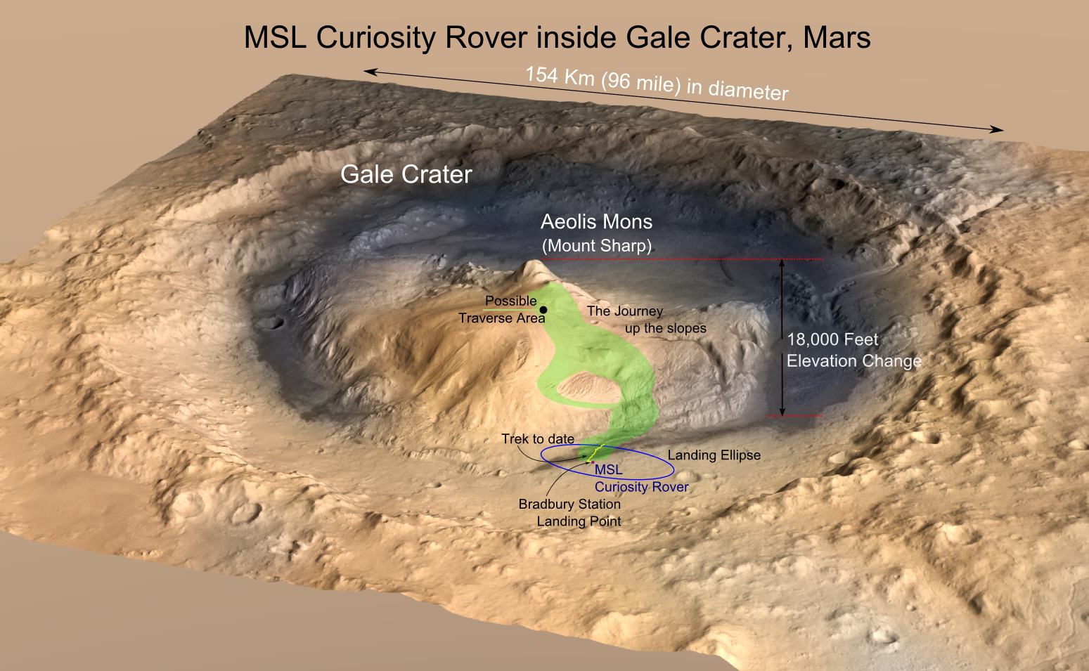
MRO image of Gale Crater illustrating the landing location and trek of the Rover Curiosity since it landed in 2012. Credits: NASA/JPL, illustration, T.Reyes
As Thomas Zurbuchen, the associate administrator for the Science Mission Directorate at NASA Headquarters, explained in a recent NASA press release:
“With these new findings, Mars is telling us to stay the course and keep searching for evidence of life. I’m confident that our ongoing and planned missions will unlock even more breathtaking discoveries on the Red Planet.”
In the first paper, the authors indicate how Curiosity’sSample Analysis at Mars (SAM) suite detected traces of methane in drill samples it took from Martian rocks. Once these rocks were heated, they released an array of organics and volatiles similar to how organic-rich sedimentary rocks do on Earth. On Earth, such deposits are indications of fossilized organic life, which may or may not be the case with the samples examined by Curiosity.
However, this evidence is bolstered by the fact that Curiosity has also found evidence that the Gale Crater was once an ancient lakebed. In addition to water, this lakebed contained all the chemical building blocks and energy sources that are necessary for life. As Jen Eigenbrode of NASA’s Goddard Space Flight Center, and the lead author of the first study, explained:
“Curiosity has not determined the source of the organic molecules. Whether it holds a record of ancient life, was food for life, or has existed in the absence of life, organic matter in materials holds chemical clues to planetary conditions and processes… The Martian surface is exposed to radiation from space. Both radiation and harsh chemicals break down organic matter. Finding ancient organic molecules in the top five centimeters of rock that was deposited when Mars may have been habitable, bodes well for us to learn the story of organic molecules on Mars with future missions that will drill deeper.”
This image illustrates possible ways methane might get into Mars’ atmosphere and also be removed from it. Credit: NASA/JPL-Caltech/SAM-GSFC/Univ. of Michigan
In the second paper, the team described how Curiosity’s SAM suite also detected seasonal variations in methane in the Martian atmosphere. These results were obtained over the course of nearly three years on Mars, which works out to almost six Earth years. While the team admits that water-rock chemistry could have generated the methane, they cannot rule out the possibility that it was biological in origin.
In the past, methane and organic molecules have been detected in Mars’ atmosphere and in drill samples, the former of which appeared to spike unpredictably. However, these new results indicate that within the Gale Crater, low levels of methane peak during the warm summer months and drop in the winter months every year. As Chris Webster, a researcher from NASA’s Jet Propulsion Laboratory (JPL) and the lead author of the second paper, explained:
“This is the first time we’ve seen something repeatable in the methane story, so it offers us a handle in understanding it. This is all possible because of Curiosity’s longevity. The long duration has allowed us to see the patterns in this seasonal ‘breathing.'”
To find this organic material, Curiosity drilled into sedimentary rocks (known as mudstone) in four areas in the Gale Crater. These rocks formed over the course of billions of years as sediments were deposited at the bottom of the ancient lake by flowing water. The drill samples were then analyzed by SAM, which used its oven to heat the samples to over 500 °C (900 °F) to release organic molecules from the powdered rock.
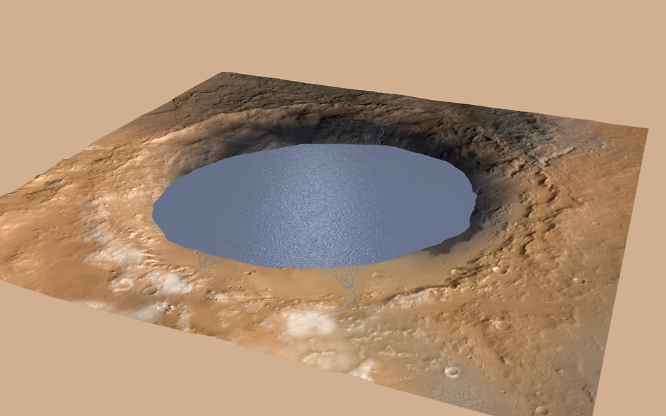
Simulated view of Gale Crater Lake on Mars. This illustration depicts a lake of water partially filling Mars’ Gale Crater, receiving runoff from snow melting on the crater’s northern rim. Credit: NASA/JPL-Caltech/ESA/DLR/FU Berlin/MSSS
These results indicate that some of the drill samples contained sulfur (which could have preserved the organic molecules) as well as thiophenes, benzene, toluene, and small carbon chains – such as propane or butene. They also indicated organic carbon concentrations of about 10 parts per million or more, which is consistent with carbon concentrations observed in Martian meteorites and about 100 times what has been previously detected on Mars’ surface.
While this does not constitute evidence of past life on Mars, these latest findings have increased confidence that future missions will find more organics, both on the surface and slightly beneath the surface. But above all, they have bolstered confidence that Mars may have once had life of its own. As Michael Meyer, the lead scientist for NASA’s Mars Exploration Program, summarized:
“Are there signs of life on Mars? We don’t know, but these results tell us we are on the right track.”
In the coming years, additional missions will also be searching for signs of past life, including NASA’s Mars 2020 rover and the European Space Agency’s ExoMars rover.The Mars 2020 rover will also leave samples behind in a cache that could be retrieved by a future crewed mission for sample-return analysis. So if there was life on Mars (or, fingers crossed, still is) we are sure to find it soon enough!
And be sure to check out this video of this latest discovery by Curiosity, courtesy of NASA’s Jet Propulsion Laboratory:
This mosaic taken by NASA's Mars Curiosity rover looks uphill at Mount Sharp, which Curiosity has been climbing since 2014. Highlighted in white is an area with clay-bearing rocks that scientists are eager to explore; it could shed additional light on the role of water in creating Mount Sharp. Credit: NASA/JPL-Caltech/MSSS
Since it landed on Mars in 2012, the Curiosity rover has made some rather startling scientific discoveries. These include the discovery of methane and organic molecules, evidence of how it lost its ancient atmosphere, and confirming that Mars once had flowing water and lakes on its surface. In addition, the rover has passed a number of impressive milestones along the way.
In fact, back in January of 2018, the rover had spent a total of 2,000 Earth days on Mars. And as of March 22nd, 2018, NASA’s Mars Curiosity rover had reached its two-thousandth Martian day (Sol) on the Red Planet! To mark the occasion, NASA released a mosaic photo that previews what the rover will be investigating next (hint: it could shed further light on whether or not Mars was habitable in the past).
The image (shown at top and below) was assembled from dozens of images taken by Curiosity‘s Mast Camera (Mastcam) on Sol 1931 (back in January). To the right, looming in the background, is Mount Sharp, the central peak in the Gale Crater (where Curiosity landed back in 2012). Since September of 2014, the rover has been climbing this feature and collecting drill samples to get a better understanding of Mars’ geological history.
Image of the mosaic taken by NASA’s Mars Curiosity rover in January of 2018 (Sol 1931). Click to enlarge. Credit: NASA/JPL-Caltech/MSSS
In the center of the image is the rover’s next destination and scientific target. This area, which scientists have been studying from orbit, is rich in clay minerals, which indicates that water once existed there. In the past, the Curiosity rover found evidence of clay minerals on the floor of the Gale Crater. This confirmed that the crater was a lake bed between 3.3 and 3.8 billion years ago.
Mount Sharp, meanwhile, is believed to have formed from sedimentary material that was deposited over a period of about 2 billion years. By examining patches of clay minerals that extend up the mountain’s side, scientists hope to gain insight into the history of Mars since then. These include how long water may have persisted on its surface and how the planet made the transition to the cold and desiccated place it is today.
The Curiosity science team is eager to analyze rock samples pulled from the clay-bearing rocks seen in the center of the image, and not just because of the results they could provide. Recently, the science team developed a new drilling technique to compensate for the failure of a faulty motor (which allows the drill to extend and retract). When the rover begins to drill again, it will be the first time since December 2016.
All told, the rover has spent a total of about 2055 Earth days (5 years and 230 days), which means Curiosity now ranks third behind the Opportunity (5170 days; 5031 sols) and the Spirit rovers (2269 days; 2208 sols) in terms of total time spent on Mars. Since it arrived on Mars in 2012, Curiosity has also traveled a total distance of 18.7 km (11.6 mi) and studied more than 180 meters (600 feet) vertical feet of rock.
But above all, Curiosity‘s greatest achievement has been the discovery that Mars once had all the necessary conditions and chemical ingredients to support microbial life. Based on their findings, Curiosity‘s international science team has concluded that habitable conditions must have lasted for at least millions of years before Mars’ atmosphere was stripped away.
Finding the evidence of this, and how the transition occurred, will not only advance our understanding of the history of Mars, but of the Solar System itself. It also might provide clues as to how Mars could be made into a warmer, wetter environment again someday!
NASA's Curiosity Mars rover used a new drill method to produce a hole on February 26 in a target named Lake Orcadie. The hole marks the first operation of the rover's drill since a motor problem began acting up more than a year ago. Credit: NASA/JPL-Caltech/MSSS
Since it landed on Mars in 2012, the Curiosity rover has used its drill to gather samples from a total of 15 sites. These samples are then deposited into two of Curiosity’s laboratory instruments – the Sample Analysis at Mars (SAM) or the Chemistry and Mineralogy X-ray Diffraction (CheMin) instrument – where they are examined to tell us more about the Red Planet’s history and evolution.
Unfortunately, in December of 2016, a key part of the drill stopped working when a faulty motor prevented the bit from extending and retracting between its two stabilizers. After managing to get the bit to extend after months of work, the Curiosity team has developed a new method for drilling that does not require stabilizers. The new method was recently tested and has been proven to be effective.
The new method involves freehand drilling, where the drill bit remains extended and the entire arm is used to push the drill forward. While this is happening, the rover’s force sensor – which was originally included to stop the rover’s arm if it received a high-force jolt – is used to takes measurements. This prevents the drill bit from drifting sideways and getting stuck in rock, as well as providing the rover with a sense of touch.
NASA’s Curiosity rover raised robotic arm with drill pointed skyward while exploring Vera Rubin Ridge at the base of Mount Sharp inside Gale Crater – backdropped by distant crater rim. Credit: NASA/JPL/Ken Kremer/kenkremer.com/Marco Di Lorenzo
The test drill took place at a site called Lake Orcadie, which is located in the upper Vera Rubin Ridge – where Curiosity is currently located. The resulting hole, which was about 1 cm (half an inch) deep was not enough to produce a scientific sample, but indicated that the new method worked. Compared to the previous method, which was like a drill press, the new method is far more freehand.
“We’re now drilling on Mars more like the way you do at home. Humans are pretty good at re-centering the drill, almost without thinking about it. Programming Curiosity to do this by itself was challenging — especially when it wasn’t designed to do that.”
This new method was the result of months of hard work by JPL engineers, who practiced the technique using their testbed – a near-exact replica of Curiosity. But as Doug Klein of JPL, one of Curiosity’s sampling engineers, indicated, “This is a really good sign for the new drilling method. Next, we have to drill a full-depth hole and demonstrate our new techniques for delivering the sample to Curiosity’s two onboard labs.”
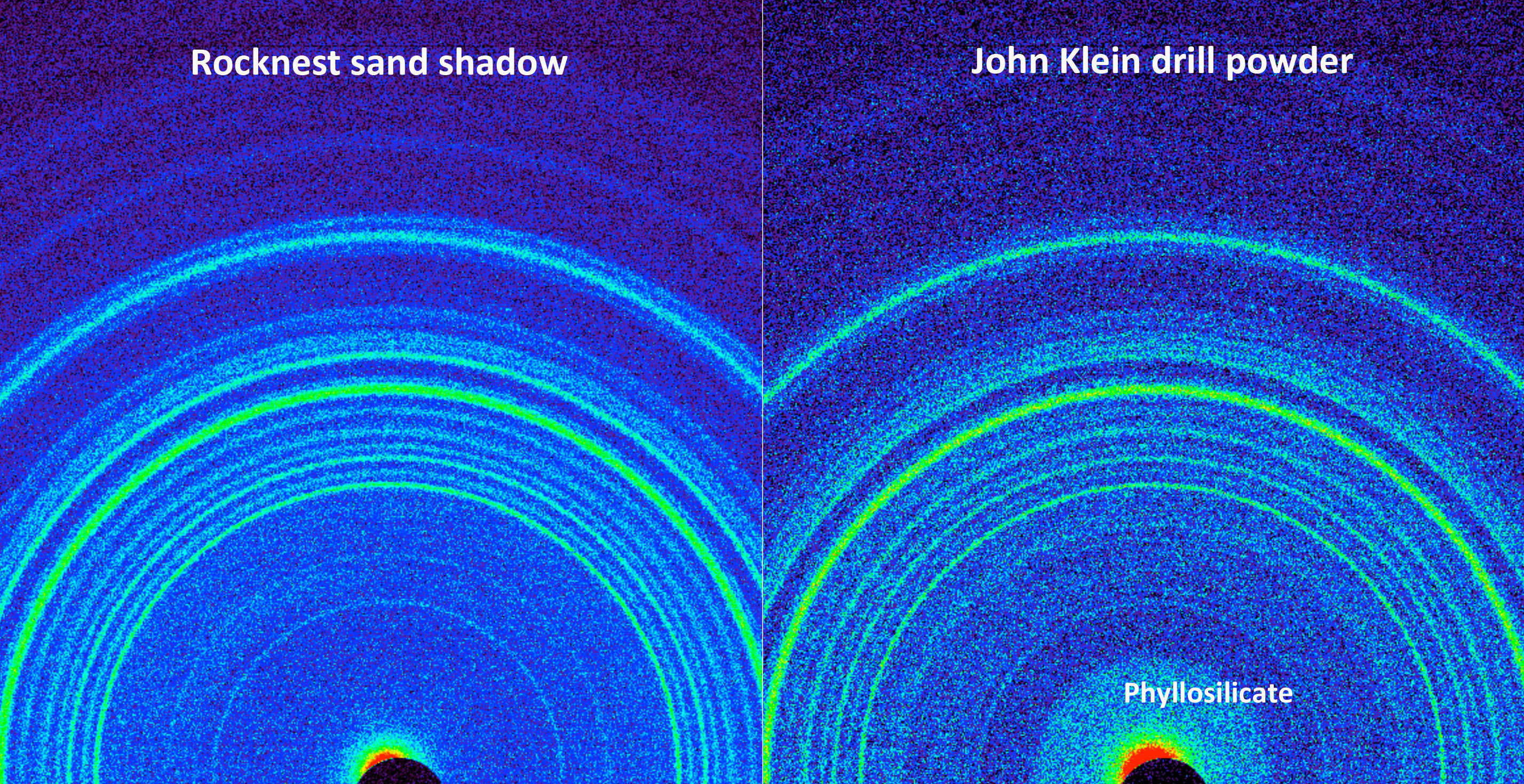
This side-by-side comparison shows the X-ray diffraction patterns of two different samples collected from the Martian surface by NASA’s Curiosity rover, as obtained by Curiosity’s Chemistry and Mineralogy instrument (CheMin). Credit: NASA/JPL-Caltech/Ames
Of course, there are some drawbacks to this new method. For one, leaving the drill in its extended position means that it no longer has access to the device that sieves and portions rock powder before delivering it to the rover’s Collection and Handling for In-Situ Martian Rock Analysis (CHIMRA) instrumet. To address this, the engineers at JPL had to invent a new way to deposit the powder without this device.
Here too, the engineers at JPL tested the method here on Earth. It consists of the drill shaking out the grains from its bit in order to deposit the sand directly in the CHIMRA instrument. While the tests have been successful here on Earth, it remains to be seen if this will work on Mars. Given that both atmospheric conditions and gravity are very different on the Red Planet, it remains to be seen if this will work there.
This drill test was the first of many that are planned. And while this first test didn’t produce a full sample, Curiosity’s science team is confident that this is a positive step towards the resumption of regular drilling. If the method proves effective, the team hopes to collect multiple samples from Vera Rubin Ridge, especially from the upper side. This area contains both gray and red rocks, the latter of which are rich in minerals that form in the presence of water.
Samples drilled from these rocks are expected to shed light on the origin of the ridge and its interaction with water. In the days ahead, Curiosity’s engineers will evaluate the results and likely attempt another drill test nearby. If enough sample is collected, they will use the rover’s Mastcam to attempt to portion the sample out and determine how much powder can be shaken from the drill bit.
Mosaic image of the Curiosity rover on Mars, which recently turned up more evidence that supports the idea that the planet was once habitability. Credit: NASA/JPL-Caltech/MSSS.
On August 5th, 2012, after spending over 8 months in space, NASA’s Curiosity rover landed on Mars. As part of the NASA Mars Science Laboratory (MSL) mission, and the latest in a series of rovers deployed to the Martian surface, Curiosity had some rather ambitious research goals. In addition to investigating Mars’ climate and geology, the rover was also tasked with revealing more about Mars’ past and determining if it ever supported microbial life.
And recently, the Curiosity rover hit another major milestone in its exploration of the Red Planet. As of January 26th, 2018 the rover has spent a total of 2,000 days on Mars, which works out to 5 years, 5 months and 21 days – or 1947 Martian days (sols). That’s especially impressive when you consider that the mission was only meant to last 687 days (668 sols), or just little under 2 years.
In all that time, the Curiosity rover has accomplished some major feats and has the scars to prove it! Some of it’s wheels have become teared, holed and cracked and its drill has been pushed almost to the point of breaking. And yet, Curiosity is still hard at work pushing itself up a mountain – both literally and figuratively! The rover has also managed to exceed everyone’s expectations.
MRO image of Gale Crater illustrating the landing location and trek of the Rover Curiosity. Credits: NASA/JPL, illustration, T.Reyes
As Ashwin Vasavada, the MSL Project Scientist, told Universe Today via email:
“In terms of challenges, the first 2000 days of Curiosity’s mission went better than I could have hoped. For much of the time, the rover remained as capable as the day it landed. We had a scare in the first year when a memory fault triggered additional problems and nearly resulted in the loss of the mission. We famously wore down our wheels pretty early, as well, but since then we’ve kept that under control. In the last year, we’ve had a major problem with our drill. That’s the only major issue currently, but we believe we’ll be back to drilling in a month or so. If that works out, we’ll amazingly be back to having all systems ready for science!”
As of the penning of this article, the rover is climbing Mount Sharp in order to collect further samples from Mars’ past. Also known as Aeolis Mons, this mountain resides in the center of the Gale Crater where Curiosity landed in 2012 and has been central to Curiosity’s mission. Standing 5,500 meters (18,000 ft) above the valley floor, Mount Sharp is believed to have formed from sediment that was slowly deposited by flowing water over billions of years.
This is all in keeping with current theories about how Mars once had a denser atmosphere and was able to sustain liquid water on its surface. But between 4.2 and 3.7 billion years ago, this atmosphere was slowly stripped away by solar wind, thus turning Mars into the cold and desiccated place that we know today. As a result, the study of Mount Sharp was always expected to reveal a great deal about Mars’ geological evolution.
Image of Mount Sharp taken by the Curiosity rover on Aug. 23rd, 2012. The layers at the base of Mt. Sharp show the geological history of Mars. Credit: NASA/JPL-Caltech/MSSS.
In it’s first year, Curiosity achieved a major milestone when the rover obtained drill samples from low-lying areas that indicated that lakes and streams existed in the Gale Crater between 3.3 to 3.8 billion years ago. In addition, the rover has also obtained ample evidence that the crater once had all the chemical elements and even a chemical source of energy needed for microbial life to exist.
“NASA’s charge to our mission was to determine whether Mars ever had conditions suitable for life,” said Vasavada. “Success was not a foregone conclusion. Would we arrive safely? Would the scientific instruments work? Would the area we chose for the landing site hold the clues we were looking for? For me, meeting each of these objectives are the highlights of the mission. I’ll never forget witnessing the launch, or nervously waiting for a safe touchdown. Discovering an ancient, freshwater lake environment at Gale crater was profound scientifically, but also was the moment that I knew that our team had delivered what we promised to NASA.”
Basically, by scaling Mount Sharp and examining the layers that were deposited over the course of billions of years, Curiosity is able to examine a living geological record of how the planet has evolved since then. Essentially, the lower layers of the mountain are believed to have been deposited 3.5 billion years ago when the Gale Crater was still a lakebed, as evidenced by the fact that they are rich in clay minerals.
The upper layers, meanwhile, are believed to have been deposited over the ensuing millions of years, during which time the lake in the Gale Crater appears to have grown, shrunk, disappeared and then reappeared. Basically, by scaling the mountain and obtaining samples, Curiosity will be able to illustrate how Mars underwent the transition from being a warmer, wetter place to a frozen and dry one.
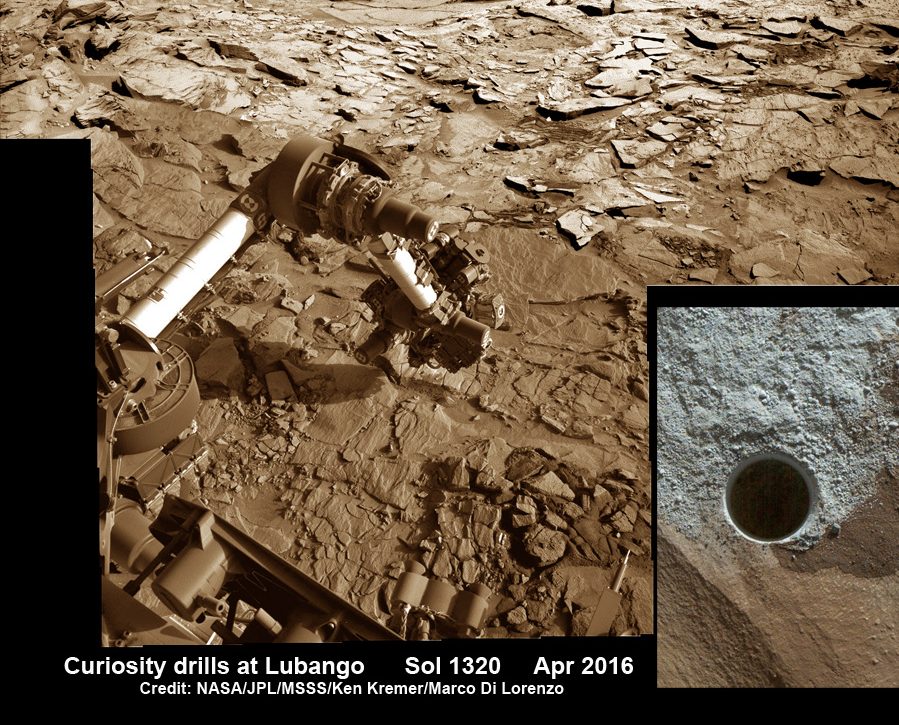
Image taken of drill sample obtained at the ‘Lubango’ outcrop target on Sol 1320, Apr. 23, 2016. Lubango is located in the Stimson unit on the lower slopes of Mount Sharp inside Gale Crater. Credit: NASA/JPL/MSSS/Ken Kremer/kenkremer.com/Marco Di Lorenzo
As Vasavada explained, this exploration is also key to answering a number of foundational questions about the search for life beyond Earth:
“Curiosity established that Mars was once a suitable home for life; it had liquid water, key chemical building blocks, and energy sources required by life in the lake and groundwater environment within Gale crater. Curiosity also has detected organic molecules in ancient rocks, in spite of all the degradation that could have occurred in three billion years. While Curiosity cannot detect life itself, knowing that Mars can preserve organic molecules bodes well for missions that will explore ancient rocks, looking for signs of past life.”
At this juncture, its not clear how much longer Curiosity will last. Considering that it has already lasted over twice as long as originally intended, it is possible the rover will remain in operation for years to come. However, unlike the Opportunity rover – who’s mission was intended to last for 90 days, but has remained in operation for 5121 days (4984 sols) – Curiosity has a shelf life.
Whereas Opportunity is powered by solar cells, Curiosity is dependent on its Multi-Mission Radioisotope Thermoelectric Generator (MMRTG). Eventually, this slow-fission reactor will exhaust its supply of nuclear fuel and the rover will be forced to come to a halt. And considering how the rover has been put through its paces in the past 5 years, there’s also the chance that it will suffer a mechanical failure.
But in the meantime, there’s plenty of work to be done and lots of opportunities for vital research. As Vasavada put it:
“Curiosity won’t last forever, but in the years we have left, I hope we can complete our traverse through the lowermost strata on Mount Sharp. We’re well over halfway through. There are changes in the composition of the rocks ahead that might tell us how the climate of Mars changed over time, perhaps ending the era of habitability. Every day on Mars still counts, perhaps even more than before. Now every new discovery adds a piece to a puzzle that’s more than halfway done; it reveals more given all the other pieces already around it.”
And be sure to check out this retrospective of the Curiosity rover’s mission, courtesy of NASA:
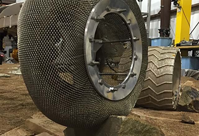
The Mars Spring Tire being tested at NASA GRS' Slope lab. Credit: NASA/JPL
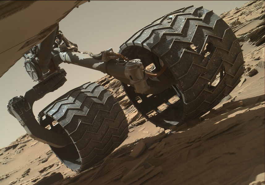
The Curiosity Rover has made some incredible discoveries during the five years it has been operating on the surface of Mars. And in the course of conducting its research, the rover has also accrued some serious mileage. However, it certainly came as a surprise when during a routine examinations in 2013, members of the Curiosity science team noted that its wheels had suffered rips in their treads (followed by breaks reported in 2017).
Looking to the future, researchers at NASA’s Glenn Research Center hope to equip next-generation rovers with a new wheel. It is based on the “Spring Tire“, which NASA developed with Goodyear back in the mid-2000s. However, rather than using coiled steel wires woven into a mesh pattern (which was part of the original design) a team of NASA scientists has created a more durable and flexible version which could revolution space exploration.
When it comes right down to it, the Moon, Mars, and other bodies in the Solar System have harsh, punishing terrain. In the case of the Moon, the main issue is the regolith (aka. Moon dust) which covers the majority of its surface. This fine dust is essentially jagged bits of lunar rock which play havoc with engines and machine components. On Mars, the situation is slightly different, with regolith and sharp rocks covering most of the terrain.
Image taken by the Mars Hand Lens Imager (MAHLI) camera showing the condition of Curiosity’s left-middle and left-rear wheels. Credit: NASA/JPL-Caltech/MSSS
In 2013, after just a year on the surface, the Curiosity rover’s wheels began to show signs of wear and tear due it traversing unexpectedly harsh terrain. This led many to worry that the rover might not be able to complete its mission. It also led many at NASA’s Glenn Research Center to reconsider a design they had been working on almost a decade prior, which was intended for renewed missions to the Moon.
For NASA Glenn, tire development has been a focus of research for about a decade now. In this respect, they are returning to a time-honored tradition of NASA engineers and scientists, which began back in the Apollo era. At the time, both the American and Russian space programs were evaluating multiple tires designs for use on the lunar surface. Overall, three major designs were proposed.
First, you had the wheels specially designed for Lunokhod rover, a Russian vehicle whose name literally translates to “Moon Walker”. The wheel design for this rover consisted of eight rigid-rim, wire-mesh tires that were connected to their axles by bicycle-type spokes. Metal cleats were also mounted on the outside of the tire to ensure better traction in the lunar dust.
Then there was NASA’s concept for a Modularized Equipment Transporter (MET), which was developed with the support of Goodyear. This unpowered cart came with two nitrogen-filled, smooth rubber tires to make it easier to pull the cart through lunar soil and over rocks. And then there was the design for the Lunar Roving Vehicle (LRV), which was the last NASA vehicle to visit the Moon.
This crewed vehicle, which Apollo astronauts used to drive around on the challenging lunar surface, relied on four large, flexible wire-mesh wheels with stiff inner frames. During the mid-2000s, when NASA began planning on mounting new missions to the Moon (and future missions to Mars), they began reevaluating the LRV tire and incorporating new materials and technologies into the design.
The fruit of this renewed research was the Spring Tire, which was the work of mechanical research engineer Vivake Asnani, who worked closely with Goodyear to develop it. The design called for an airless, compliant tire made up of hundreds of coiled steel wires, which were then woven into a flexible mesh. This not only ensured light weight, but also gave the tires the ability to support high loads while conforming to the terrain.
To see how the Spring Tire would fare on Mars, engineers at NASA’s Glenn Research Center began testing them in the Slope lab, where they ran them through an obstacle course that simulated the Martian environment. While the tires performed generally well in simulated sand, they experienced problems when the wire mesh deformed after passing over jagged rocks.
To address this, Colin Creager and Santo Padua (a NASA engineer and materials scientist, respectively) discussed possible alternatives. In time, they agreed the steel wires should be replaced with nickel titanium, a shape memory alloy that is capable of retaining its shape under tough conditions. As Padua explained in a NASA Glenn video segment, the inspiration to use this alloy was very serendipitous:
“I just happened to be over in the building here, where the Slope lab is. And I was over here for a different meeting for the work that I do in shape memory alloys, and I happen to run into Colin in the hall. And I was like ‘what are you doing back and why aren’t you over in the impact lab?’ – because I knew him as a student. He said, ‘well, I’ve graduated, and I’ve been working out here full-time for awhile… I work in Slope.”
Despite working at JPL for ten years, Padua had not seen the Slope lab before and accepted an invitation to see what they were working on. After entering the lab and looking at the Spring Tires they were testing, Padua asked if they were experiencing problems with deformation. When Creager admitted that they were, Padua proposed a solution which just happened to be his field of expertise.
“I had never even heard of the term shape memory alloys before, but I knew [Padua] was a materials science engineer,” said Creager. “And so, since then we’ve been collaborating on these tires using his materials expertise, especially in shape memory alloys, to come up with this new tire that we think is really going to revolutionize planetary rover tires and potentially even tires for Earth too.”
The key to shape memory alloys is their atomic structure, which is assembled in such a way that the material “remember” its original shape and is able to return to it after being subjected to deformation and strain. After building the shape memory alloy tire, the Glenn engineers sent it to the Jet Propulsion Laboratory, where it was tested in the Mars Life Test Facility.
Overall, the tires not only performed well in simulated Martian sand, but were able to withstand going over punishing rocky outcroppings without difficulty. Even after the tires were deformed all the way down to their axles, they were able to retain their original shape. They also managed to do this while carrying a significant payload, which is another prerequisite when developing tires for exploration vehicles and rovers.
The priorities for the Mars Spring Tire (MST) are to offer greater durability, better traction in soft sand, and lighter weight. As NASA indicates on the MST website (part of the Glenn Research Center’s website), there are three major benefits to developing high performing compliant tires like the Spring Wheel:
“First, they would allow rovers to explore greater regions of the surface than currently possible. Secondly, because they conform to the terrain and do not sink as much as rigid wheels, they can carry heavier payloads for the same given mass and volume. Lastly, because the compliant tires can absorb energy from impacts at moderate to high speeds, they can be used on crewed exploration vehicles which are expected to move at speeds significantly higher than the current Mars rovers.”
The first available opportunity to test these tires out is just a few years away, when NASA’s Mars 2020 Rover will be sent to the surface of the Red Planet. Once there, the rover will pick up where Curiosity and other rovers have left off, searching for signs of life in Mars’ harsh environment. The rover is also tasked with preparing samples that will eventually be returned to Earth by a crewed mission, which is expected to take place sometime in the 2030s.
NASA’s Curiosity rover raised robotic arm with drill pointed skyward while exploring Vera Rubin Ridge at the base of Mount Sharp inside Gale Crater - backdropped by distant crater rim. This navcam camera mosaic was stitched from raw images taken on Sol 1833, Oct. 2, 2017 and colorized. Credit: NASA/JPL/Ken Kremer/kenkremer.com/Marco Di Lorenzo
NASA’s Curiosity rover raised robotic arm with drill pointed skyward while exploring Vera Rubin Ridge at the base of Mount Sharp inside Gale Crater – backdropped by distant crater rim. This navcam camera mosaic was stitched from raw images taken on Sol 1833, Oct. 2, 2017 and colorized. Credit: NASA/JPL/Ken Kremer/kenkremer.com/Marco Di Lorenzo
5 years after a heart throbbing Martian touchdown, Curiosity is climbing Vera Rubin Ridge in search of “aqueous minerals” and “clays” for clues to possible past life while capturing “truly breathtaking” vistas of humongous Mount Sharp – her primary destination – and the stark eroded rim of the Gale Crater landing zone from ever higher elevations, NASA scientists tell Universe Today in a new mission update.
“Curiosity is doing well, over five years into the mission,” Michael Meyer, NASA Lead Scientist, Mars Exploration Program, NASA Headquarters told Universe Today in an interview.
“A key finding is the discovery of an extended period of habitability on ancient Mars.”
The car-sized rover soft landed on Mars inside Gale Crater on August 6, 2012 using the ingenious and never before tried “sky crane” system.
A rare glimpse of Curiosity’s arm and turret mounted skyward pointing drill is illustrated with our lead mosaic from Sol 1833 of the robot’s life on Mars – showing a panoramic view around the alien terrain from her current location in October 2017 while actively at work analyzing soil samples.
“Your mosaic is absolutely gorgeous!’ Jim Green, NASA Director Planetary Science Division, NASA Headquarters, Washington D.C., told Universe Today
“We are at such a height on Mt Sharp to see the rim of Gale Crater and the top of the mountain. Truly breathtaking.”
The rover has ascended more than 300 meters in elevation over the past 5 years of exploration and discovery from the crater floor to the mountain ridge. She is driving to the top of Vera Rubin Ridge at this moment and always on the lookout for research worthy targets of opportunity.
Additionally, the Sol 1833 Vera Rubin Ridge mosaic, stitched by the imaging team of Ken Kremer and Marco Di Lorenzo, shows portions of the trek ahead to the priceless scientific bounty of aqueous mineral signatures detected by spectrometers years earlier from orbit by NASA’s fleet of Red Planet orbiters.
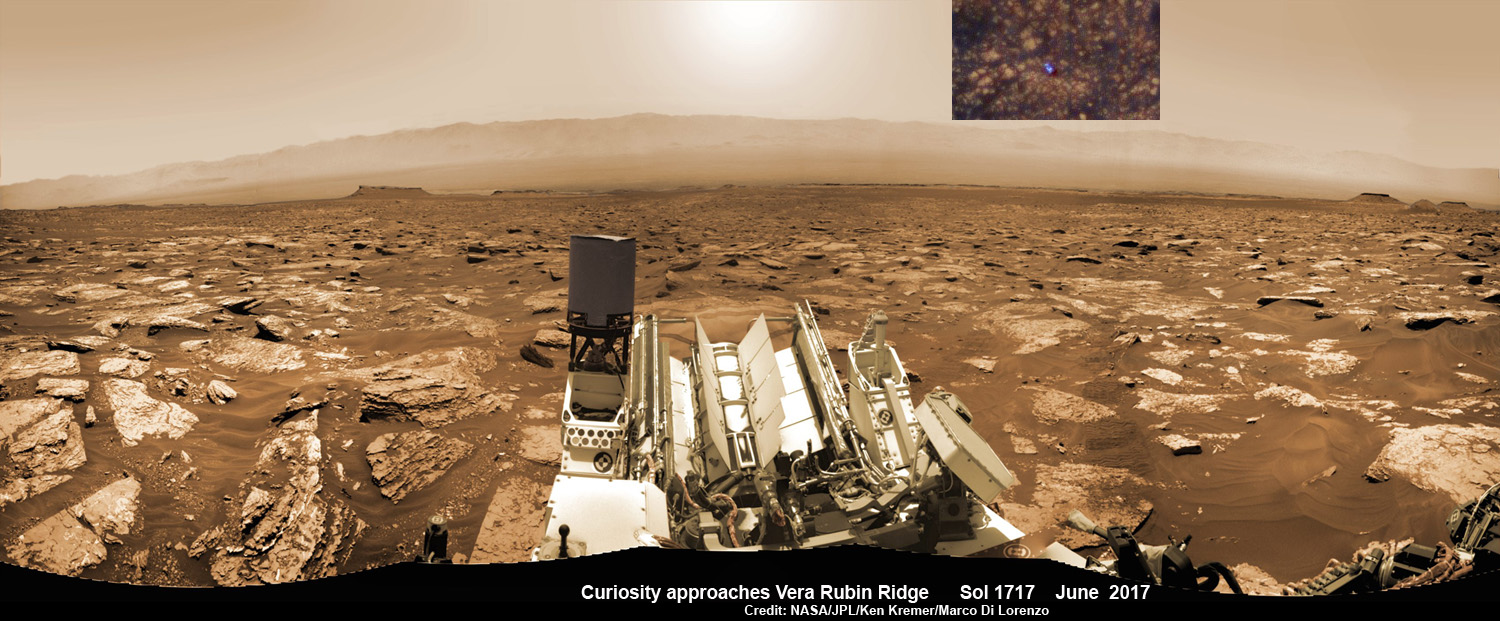
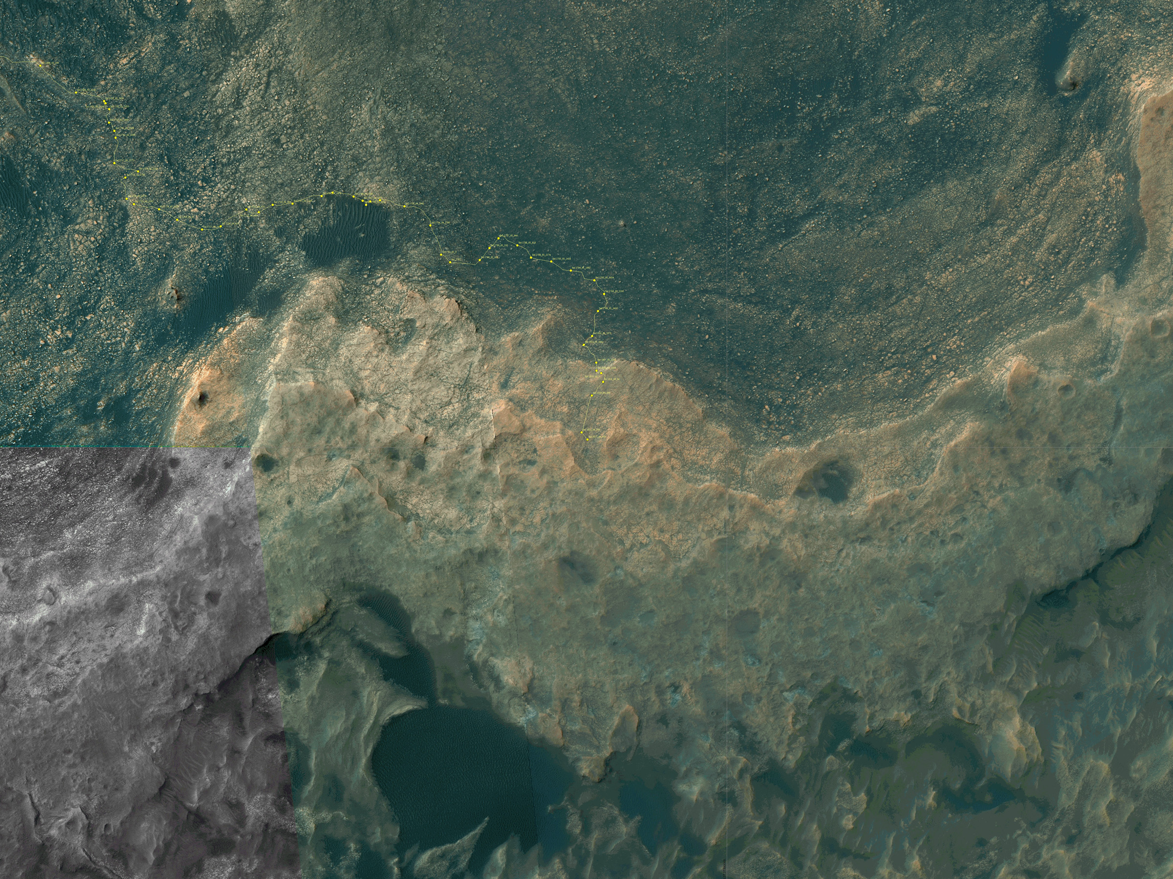
NASA’s Curiosity rover as seen simultaneously on Mars surface and from orbit on Sol 1717, June 5, 2017. The robot snapped this self portrait mosaic view while approaching Vera Rubin Ridge at the base of Mount Sharp inside Gale Crater – backdropped by distant crater rim. This navcam camera mosaic was stitched from raw images and colorized. Inset shows overhead orbital view of Curiosity (blue feature) amid rocky mountainside terrain taken the same day by NASA’s Mars Reconnaissance Orbiter. Credit: NASA/JPL/Ken Kremer/kenkremer.com/Marco Di Lorenzo
“Curiosity is on Vera Rubin Ridge (aka Hematite Ridge) – it is the first aqueous mineral signature that we have seen from space, a driver for selecting Gale Crater,” NASA HQ Mars Lead Scientist Meyer elaborated.
“And now we have access to it.”
The Sol 1833 photomosaic illustrates Curiosity maneuvering her 7 foot long (2 meter) robotic arm during a period when she was processing and delivering a sample of the “Ogunquit Beach” for drop off to the inlet of the CheMin instrument earlier in October. The “Ogunquit Beach” sample is dune material that was collected at Bagnold Dune II this past spring.
The sample drop is significant because the drill has not been operational for some time.
“Ogunquit Beach” sediment materials were successfully delivered to the CheMin and SAM instruments over the following sols and multiple analyses are in progress.
To date three CheMin integrations of “Ogunquit Beach” have been completed. Each one brings the mineralogy into sharper focus.
Researchers used the Mastcam on NASA’s Curiosity Mars rover to gain this detailed view of layers in “Vera Rubin Ridge” from just below the ridge. The scene combines 70 images taken with the Mastcam’s right-eye, telephoto-lens camera, on Aug. 13, 2017. Credit: NASA/JPL-Caltech/MSSS
What’s the status of the rover health at 5 years, the wheels and the drill?
“All the instruments are doing great and the wheels are holding up,” Meyer explained.
“When 3 grousers break, 60% life has been used – this has not happened yet and they are being periodically monitored. The one exception is the drill feed (see detailed update below).”
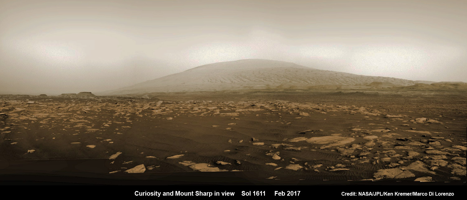
NASA’s Curiosity rover explores sand dunes inside Gale Crater with Mount Sharp in view on Mars on Sol 1611, Feb. 16, 2017, in this navcam camera mosaic, stitched from raw images and colorized. Credit: NASA/JPL/Ken Kremer/kenkremer.com/Marco Di Lorenzo
NASA’s 1 ton Curiosity Mars Science Laboratory (MSL) rover is now closer than ever to the mineral signatures that were the key reason why Mount Sharp was chosen as the robots landing site years ago by the scientists leading the unprecedented mission.
Along the way from the ‘Bradbury Landing’ zone to Mount Sharp, six wheeled Curiosity has often been climbing. To date she has gained over 313 meters (1027 feet) in elevation – from minus 4490 meters to minus 4177 meters today, Oct. 19, 2017, said Meyer.
The low point was inside Yellowknife Bay at approx. minus 4521 meters.
VRR alone stands about 20 stories tall and gains Curiosity approx. 65 meters (213 feet) of elevation to the top of the ridge. Overall the VRR traverse is estimated by NASA to take drives totaling more than a third of a mile (570 m).
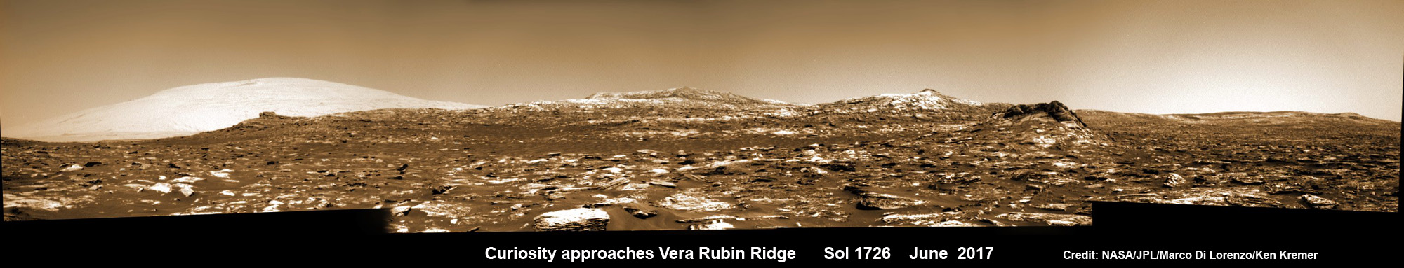
Curiosity images Vera Rubin Ridge during approach backdropped by Mount Sharp. This navcam camera mosaic was stitched from raw images taken on Sol 1726, June 14, 2017 and colorized. Credit: NASA/JPL/Marco Di Lorenzo/Ken Kremer/kenkremer.com
“Vera Rubin Ridge” or VRR is also called “Hematite Ridge.” It’s a narrow and winding ridge located on the northwestern flank of Mount Sharp. It was informally named earlier this year in honor of pioneering astrophysicist Vera Rubin.
The intrepid robot reached the base of the ridge in early September.
The ridge possesses steep cliffs exposing stratifications of large vertical sedimentary rock layers and fracture filling mineral deposits, including the iron-oxide mineral hematite, with extensive bright veins.
VRR resists erosion better than the less-steep portions of the mountain below and above it, say mission scientists.
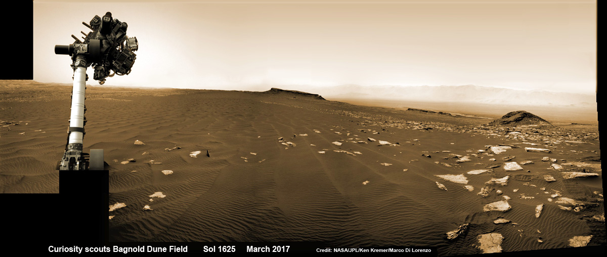
Curiosity rover raises robotic arm high while scouting the Bagnold Dune Field and observing dust devils inside Gale Crater on Mars on Sol 1625, Mar. 2, 2017, in this navcam camera mosaic stitched from raw images and colorized. Note: Wheel tracks at right, distant crater rim in background. Credit: NASA/JPL/Ken Kremer/kenkremer.com/Marco Di Lorenzo
What’s ahead for Curiosity in the coming weeks and months exploring VRR before moving onward and upwards to higher elevation?
“Over the next several months, Curiosity will explore Vera Rubin Ridge,” Meyer replied.
“This will be a big opportunity to ground-truth orbital observations. Of interest, so far, the hematite of VRR does not look that different from what we have been seeing all along the Murray formation. So, big question is why?”
“The view from VRR also provides better access to what’s ahead in exploring the next aqueous mineral feature – the clay, or phyllosilicates, which can be indicators of specific environments, putting constraints on variables such as pH and temperature,” Meyer explained.
The clay minerals or phyllosilicates form in more neutral water, and are thus extremely scientifically interesting since pH neutral water is more conducive to the origin and evolution of Martian microbial life forms, if they ever existed.
How far away are the clays ahead and when might Curiosity reach them?
“As the crow flies, the clays are about 0.5 km,” Meyer replied. “However, the actual odometer distance and whether the clays are where we think they are – area vs. a particular location – can add a fair degree of variability.”
The clay rich area is located beyond the ridge.
Over the past few months Curiosity make rapid progress towards the hematite-bearing location of Vera Rubin Ridge after conducting in-depth exploration of the Bagnold Dunes earlier this year.
“Vera Rubin Ridge is a high-standing unit that runs parallel to and along the eastern side of the Bagnold Dunes,” said Mark Salvatore, an MSL Participating Scientist and a faculty member at Northern Arizona University, in a mission update.
“From orbit, Vera Rubin Ridge has been shown to exhibit signatures of hematite, an oxidized iron phase whose presence can help us to better understand the environmental conditions present when this mineral assemblage formed.”
Curiosity is using the science instruments on the mast, deck and robotic arm turret to gather detailed research measurements with the cameras and spectrometers. The pair of miniaturized chemistry lab instruments inside the belly – CheMin and SAM – are used to analyze the chemical and elemental composition of pulverized rock and soil gathered by drilling and scooping selected targets during the traverse.
A key instrument is the drill which has not been operational. I asked Meyer for a drill update.
“The drill feed developed problems retracting (two stabilizer prongs on either side of the drill retract, controlling the rate of drill penetration),” Meyer replied.
“Because the root cause has not been found (think FOD) and the concern about the situation getting worse, the drill feed has been retracted and the engineers are working on drilling without the stabilizing prongs.”
“Note, a consequence is that you can still drill and collect sample but a) there is added concern about getting the drill stuck and b) a new method of delivering sample needs to be developed and tested (the drill feed normally needs to be moved to move the sample into the chimera). One option that looks viable is reversing the drill – it does work and they are working on the scripts and how to control sample size.”
Ascending and diligently exploring the sedimentary lower layers of Mount Sharp, which towers 3.4 miles (5.5 kilometers) into the Martian sky, is the primary destination and goal of the rover’s long term scientific expedition on the Red Planet.
“Lower Mount Sharp was chosen as a destination for the Curiosity mission because the layers of the mountain offer exposures of rocks that record environmental conditions from different times in the early history of the Red Planet. Curiosity has found evidence for ancient wet environments that offered conditions favorable for microbial life, if Mars has ever hosted life,” says NASA.
Stay tuned. In part 2 we’ll discuss the key findings from Curiosity’s first 5 years exploring the Red Planet.
As of today, Sol 1850, Oct. 19, 2017, Curiosity has driven over 10.89 miles (17.53 kilometers) since its August 2012 landing inside Gale Crater from the landing site to the ridge, and taken over 445,000 amazing images.
Stay tuned here for Ken’s continuing Earth and planetary science and human spaceflight news.
Map shows route driven by NASA’s Mars rover Curiosity through Sol 1827 of the rover’s mission on Mars (September 27, 2017). Numbering of the dots along the line indicate the sol number of each drive. North is up. Since touching down in Bradbury Landing in August 2012, Curiosity has driven 10.84 miles (17.45 kilometers). The base image from the map is from the High Resolution Imaging Science Experiment Camera (HiRISE) in NASA’s Mars Reconnaissance Orbiter. Credit: NASA/JPL/UACuriosity’s Traverse Map Through Sol 1717. This map shows the route driven by NASA’s Mars rover Curiosity through the 1717 Martian day, or sol, of the rover’s mission on Mars (June 05, 2017). The base image from the map is from the High Resolution Imaging Science Experiment Camera (HiRISE) in NASA’s Mars Reconnaissance Orbiter. Credit: NASA/JPL-Caltech/Univ. of Arizona
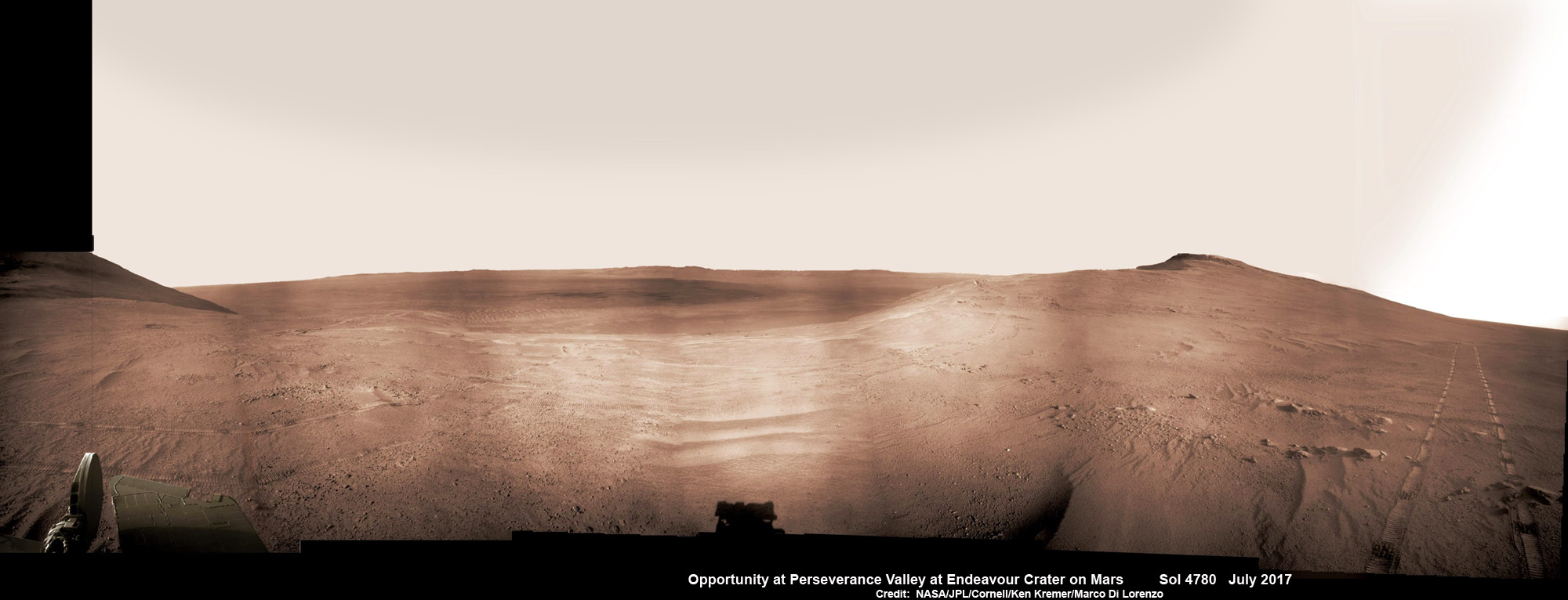
Historic 1st descent down Martian gully. Panoramic view looking down Perseverance Valley after entry at top was acquired by NASA’s Opportunity rover scanning from north to south. It shows numerous wheel tracks at left, center and right as rover conducted walkabout tour prior to starting historic first decent down a Martian gully - possibly carved by water - and looks into the interior of Endeavour crater. Perseverance Valley terminates down near the crater floor in the center of the panorama. The far rim of Endeavour crater is seen in the distance, beyond the dark floor. Rover mast shadow at center and deck at left. This navcam camera photo mosaic was assembled by Ken Kremer and Marco Di Lorenzo from raw images taken on Sol 4780 (5 July 2017) and colorized. Credit: NASA/JPL/Cornell/Ken Kremer/kenkremer.com/Marco Di Lorenzo
Historic 1st descent down Martian gully. Panoramic view looking down Perseverance Valley after entry at top was acquired by NASA’s Opportunity rover scanning from north to south. It shows numerous wheel tracks at left, center and right as rover conducted walkabout tour prior to starting historic first decent down a Martian gully – possibly carved by water – and looks into the interior of Endeavour crater. Perseverance Valley terminates down near the crater floor in the center of the panorama. The far rim of Endeavour crater is seen in the distance, beyond the dark floor. Rover mast shadow at center and deck at left. This navcam camera photo mosaic was assembled by Ken Kremer and Marco Di Lorenzo from raw images taken on Sol 4780 (5 July 2017) and colorized. Credit: NASA/JPL/Cornell/Ken Kremer/kenkremer.com/Marco Di Lorenzo
From the precipice of “Perseverance Valley” NASA’s teenaged Red Planet robot Opportunity has begun the historic first ever descent of an ancient Martian gully – that’s simultaneously visually and scientifically “tantalizing” – on an expedition to discern ‘How was it carved?’; by water or other means, Jim Green, NASA’s Planetary Sciences Chief tells Universe Today.
Since water is an indispensable ingredient for life as we know it, the ‘opportunity’ for Opportunity to study a “possibly water-cut” gully on Mars for the first time since they were discovered over four decades ago by NASA orbiters offers a potential scientific bonanza.
“Gullies on Mars have always been of intense interest since first observed by our orbiters,” Jim Green, NASA’s Planetary Sciences Chief explained to Universe Today.
“How were they carved? muses Green. “Water is a natural explanation but this is another planet. Now we have a chance to find out for real!”
Their origin and nature has been intensely debated by researchers for decades. But until now the ability to gather real ‘ground truth’ science by robotic or human explorers has remained elusive.
“This will be the first time we will acquire ground truth on a gully system that just might be formed by fluvial processes,” Ray Arvidson, Opportunity Deputy Principal Investigator of Washington University in St. Louis, told Universe Today.
“Perseverance Valley” is located along the eroded western rim of gigantic Endeavour crater – as illustrated by our exclusive photo mosaics herein created by the imaging team of Ken Kremer and Marco Di Lorenzo.
After arriving at the upper entryway to “Perseverance Valley” the six wheeled rover drove back and forth to gather high resolution imagery of the inner slope for engineers to create a 3D elevation map and plot a safe driving path down – as illustrated in our lead mosaic showing the valley and extensive wheel tracks at left, center and right.
Having just this week notched an astounding 4800 Sols roving the Red Planet, NASA’s resilient Opportunity rover has started driving down from the top of “Perseverance Valley” from the spillway overlooking the upper end of the ancient fluid-carved Martian valley into the unimaginably vast eeriness of alien Endeavour crater.
Water, ice or wind may have flowed over the crater rim and into the crater from the spillway.
“It is a tantalizing scene,” said Opportunity Deputy Principal Investigator Ray Arvidson of Washington University in St. Louis, in a statement. “You can see what appear to be channels lined by boulders, and the putative spillway at the top of Perseverance Valley. We have not ruled out any of the possibilities of water, ice or wind being responsible.”
Toward the right side of this scene is a broad notch in the crest of the western rim of Endeavour Crater. Wheel tracks in that area were left by NASA’s Mars Exploration Rover Opportunity as it observed “Perseverance Valley” from above in the spring of 2017. The valley is a major destination for the rover’s extended mission. It descends out of sight on the inner slope of the rim, extending down and eastward from that notch. The component pancam images for this view from a position outside the crater were taken during the span of June 7 to June 19, 2017, sols 4753 to 4765. Credit: NASA/JPL-Caltech/Cornell/Arizona State Univ.
“With the latest drive on sol 4782, Opportunity began the long drive down the floor of Perseverance Valley here on Endeavour crater, says Larry Crumpler, a rover science team member from the New Mexico Museum of Natural History & Science.
“This is rather historic in that it represents the first time that a rover has driven down an apparent water-cut valley on Mars. Over the next few months Opportunity will explore the floor and sides of the valley for evidence of the scale and timing of the fluvial activity, if that is what is represents.”
This mosaic view looks down from inside the upper end of “Perseverance Valley” on the inner slope of Endeavour Crater’s western rim after Opportunity started driving down the Martian gully. The scene behind the shadow of the rover’s mast shows Perseverance Valley descending to the floor of Endeavour Crater. This navcam camera photo mosaic was assembled from raw images taken on Sol 4782 (7 July 2017) and colorized. Credit: NASA/JPL/Cornell/Marco Di Lorenzo/Ken Kremer/kenkremer.com
NASA’s unbelievably long lived Martian robot reached a “spillway” at the top of “Perseverance Valley” in May after driving southwards for weeks from the prior science campaign at a crater rim segment called “Cape Tribulation.”
“Investigations in the coming weeks will “endeavor” to determine whether this valley was eroded by water or some other dry process like debris flows,” explains Crumpler.
“It certainly looks like a water cut valley. But looks aren’t good enough. We need additional evidence to test that idea.”
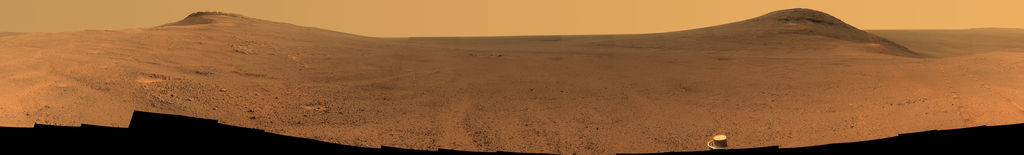
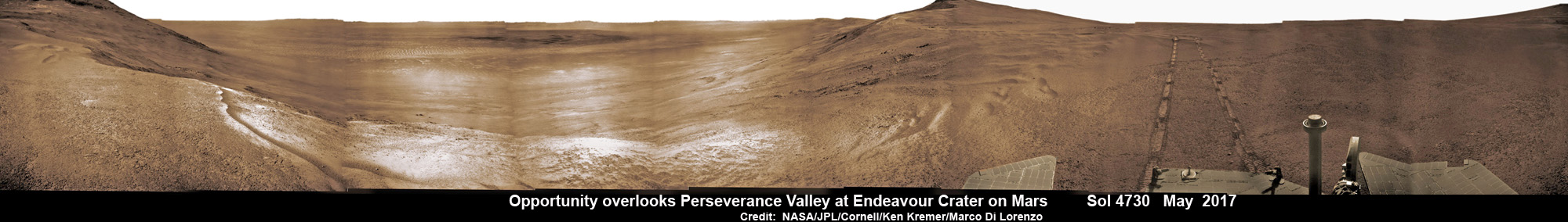
NASA’s Opportunity rover acquired this Martian panoramic view from a promontory that overlooks Perseverance Valley below – scanning from north to south. It is centered on due East and into the interior of Endeavour crater. Perseverance Valley descends from the right and terminates down near the crater floor in the center of the panorama. The far rim of Endeavour crater is seen in the distance, beyond the dark floor. Rover deck and wheel tracks at right. This navcam camera photo mosaic was assembled from raw images taken on Sol 4730 (14 May 2017) and colorized. Credit: NASA/JPL/Cornell/Ken Kremer/kenkremer.com/Marco Di Lorenzo
The valley slices downward from the crest line through the rim from west to east at a breathtaking slope of about 15 to 17 degrees – and measures about two football fields in length!
Huge Endeavour crater spans some 22 kilometers (14 miles) in diameter on the Red Planet. Perseverance Valley slices eastwards at approximately the 8 o’clock position of the circular shaped crater. It sits just north of a rim segment called “Cape Byron.”
Why go and explore the gully at Perseverance Valley?
“Opportunity will traverse to the head of the gully system [at Perseverance] and head downhill into one or more of the gullies to characterize the morphology and search for evidence of deposits,” Arvidson elaborated to Universe Today.
“Hopefully test among dry mass movements, debris flow, and fluvial processes for gully formation. The importance is that this will be the first time we will acquire ground truth on a gully system that just might be formed by fluvial processes. Will search for cross bedding, gravel beds, fining or coarsening upward sequences, etc., to test among hypotheses.”
Exploring the ancient valley is the main science destination of the current two-year extended mission (EM #10) for the teenaged robot, that officially began Oct. 1, 2016. It’s just the latest in a series of extensions going back to the end of Opportunity’s prime mission in April 2004.
Before starting the gully descent, Opportunity conducted a walkabout at the top of the Perseverance Valley in the spillway to learn more about the region before driving down.
“The walkabout is designed to look at what’s just above Perseverance Valley,” said Opportunity Deputy Principal Investigator Ray Arvidson of Washington University in St. Louis, in a statwemwent. “We see a pattern of striations running east-west outside the crest of the rim.”
“We want to determine whether these are in-place rocks or transported rocks,” Arvidson said. “One possibility is that this site was the end of a catchment where a lake was perched against the outside of the crater rim. A flood might have brought in the rocks, breached the rim and overflowed into the crater, carving the valley down the inner side of the rim. Another possibility is that the area was fractured by the impact that created Endeavour Crater, then rock dikes filled the fractures, and we’re seeing effects of wind erosion on those filled fractures.”
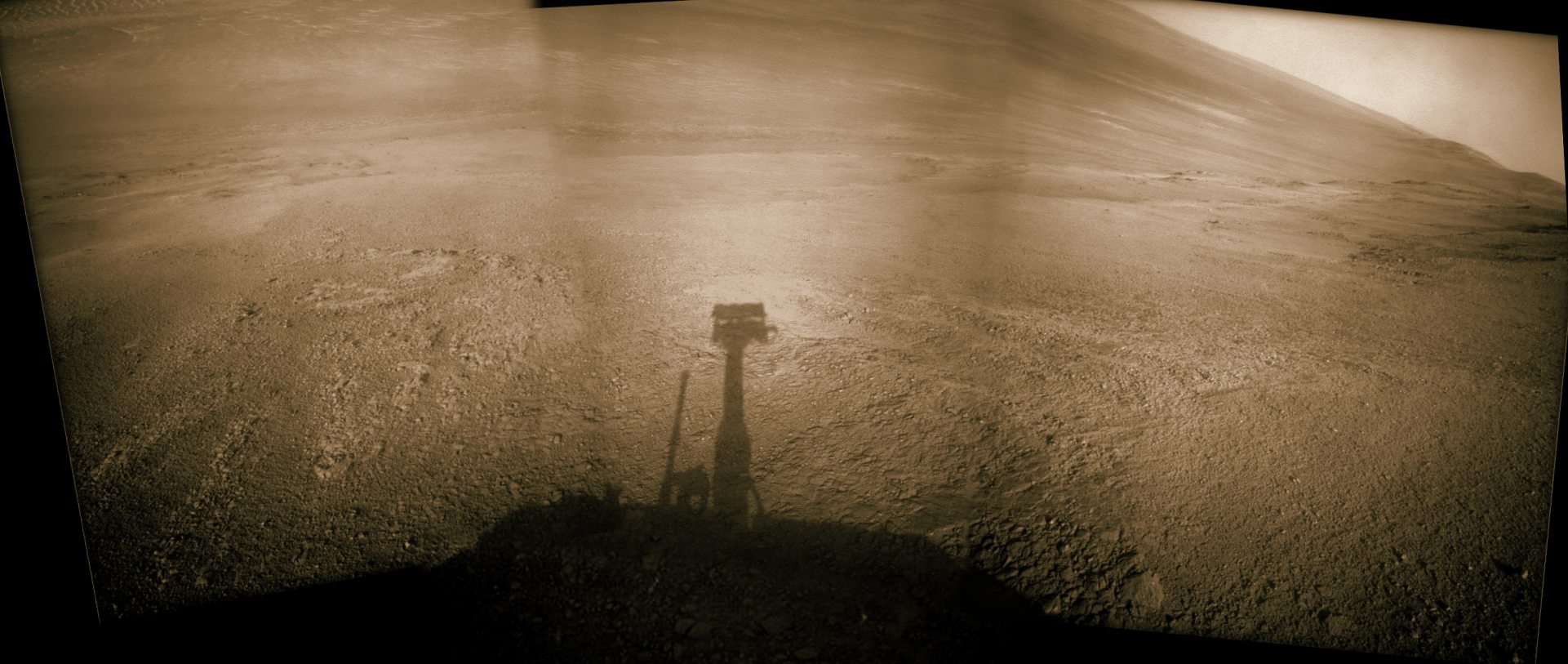
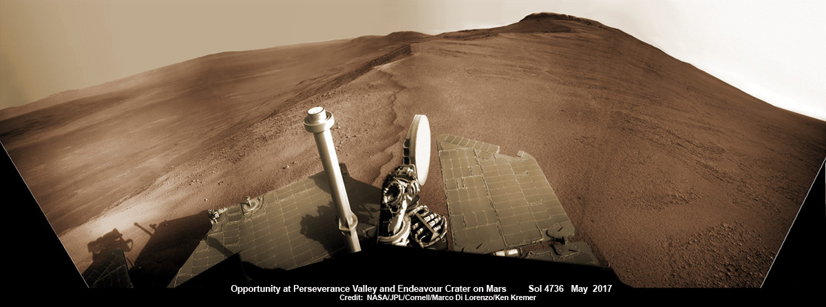
Opportunity rover looks south from the top of Perseverance Valley along the rim of Endeavour Crater on Mars in this partial self portrait including the rover deck and solar panels. Perseverance Valley descends from the right and terminates down near the crater floor. This navcam camera photo mosaic was assembled from raw images taken on Sol 4736 (20 May 2017) and colorized. Credit: NASA/JPL/Cornell/Marco Di Lorenzo/Ken Kremer/kenkremer.com
Having begun the long awaited gully descent, further movements are temporarily on hold since the start of the solar conjunction period which blocks communications between Mars and Earth for about the next two weeks, since Mars is directly behind the sun.
In the meantime, Opportunity will still collect very useful panoramic images and science data while standing still.
The solar conjunction moratorium on commanding extends from July 22 to Aug. 1, 2017.
As of today, July 27, 2017, long lived Opportunity has survived over 4800 Sols (or Martian days) roving the harsh environment of the Red Planet.
Opportunity has taken over 221,625 images and traversed over 27.95 miles (44.97 kilometers.- more than a marathon.
See our updated route map below. It shows the context of the rovers over 13 year long traverse spanning more than the 26 mile distance of a Marathon runners race.
The rover surpassed the 27 mile mark milestone on November 6, 2016 (Sol 4546) and will soon surpass the 28 mile mark.
As of Sol 4793 (July 18, 2017) the power output from solar array energy production is currently 332 watt-hours with an atmospheric opacity (Tau) of 0.774 and a solar array dust factor of 0.534, before heading into another southern hemisphere Martian winter later in 2017. It will count as Opportunity’s 8th winter on Mars.
Meanwhile Opportunity’s younger sister rover Curiosity traverses up the lower sedimentary layers at the base of Mount Sharp.
And NASA continues building the next two robotic missions due to touch down in 2018 and 2020.
NASA as well is focusing its human spaceflight efforts on sending humans on a ‘Journey to Mars’ in the 2030s with the Space Launch System (SLS) mega rocket and Orion deep space crew capsule.
Stay tuned here for Ken’s continuing Earth and planetary science and human spaceflight news.
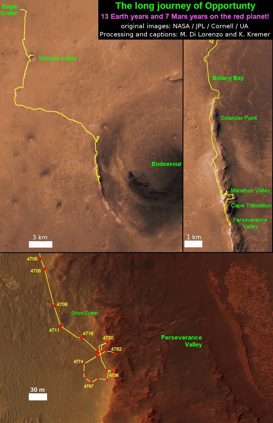
13 Year Traverse Map for NASA’s Opportunity rover from 2004 to 2017. This map shows the entire 43 kilometer (27 mi) path the rover has driven on the Red Planet during over 13 years and more than a marathon runners distance for over 4782 Sols, or Martian days, since landing inside Eagle Crater on Jan 24, 2004 – to current location at the western rim of Endeavour Crater. After studying Spirit Mound and ascending back uphill the rover has reached her next destination in May 2017- the Martian water carved gully at Perseverance Valley near Orion crater. Rover surpassed Marathon distance on Sol 3968 after reaching 11th Martian anniversary on Sol 3911. Opportunity discovered clay minerals at Esperance – indicative of a habitable zone – and searched for more at Marathon Valley. Credit: NASA/JPL/Cornell/ASU/Marco Di Lorenzo/Ken Kremer/kenkremer.com