An Awesome View of Curiosity’s Tummy

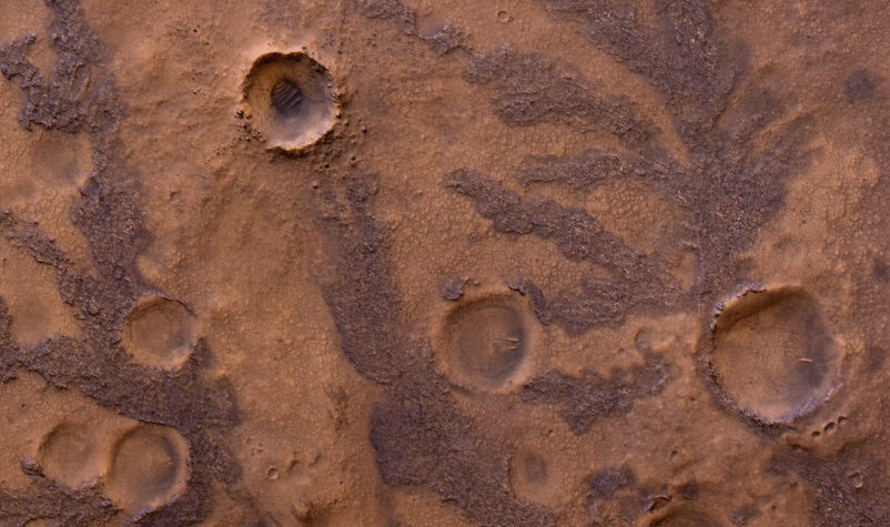
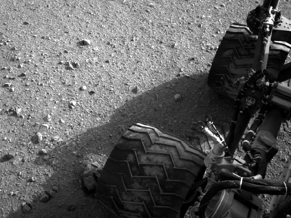
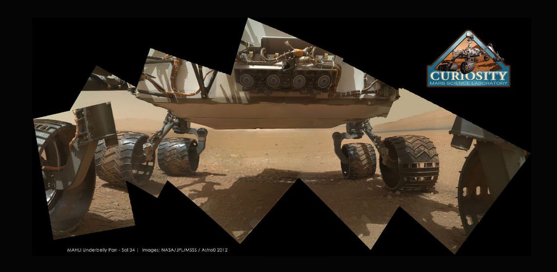
Curiosity’s underside as imaged by the MAHLI camera. Credit: NASA/JPL/MSSS; image editing by Astro0.

One of Curiosity’s amazing color cameras, the Mars Hand Lens Imager (MAHLI) that is mounted on the turret at the end of the MSL robotic arm, is now officially in action, with its dust cover removed over the weekend. The first picture it sent back to Earth was of the soil in its field of view (see below). That’s great, as the camera’s purpose is to acquire close-up images of materials on the Martian surface—rocks, fine particles and even frost. But then engineers commanded the camera to take a look at Curiosity’s underbelly – the rover’s ‘tummy’ so to speak. And the views are awesome, especially when some of the image wizards at UnmannedSpaceflight stitched a few of the images together to put together a mosaic of the entire view of the rover’s underside. This image was put together by Astro0 at UMSF. Click the image to see a larger version on his website.

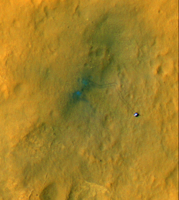
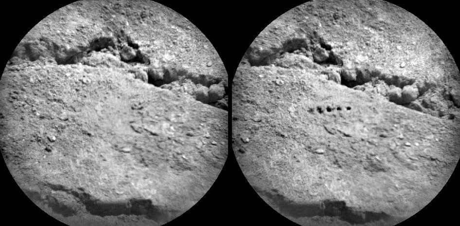
The first image to come from Curiosity’s Mars Hand Lens Imager (MAHLI) with the dust cap off. Credit: NASA/MSL-Caltech

MAHLI, built by Malin Space Science Systems (MSSS) will be used to help characterize the geology of the site investigated by MSL, and it will be used to document the materials being examined by MSL’s geochemical and mineralogical experiments.

You can see the “raw images” at the MSL website, the images that are just being beamed back from the rover, and see more at UnmannedSpaceflight; Emily Lakdawalla at the Planetary Blog also has some images she has put together from MAHLI’s views of Curiosity’s underside.

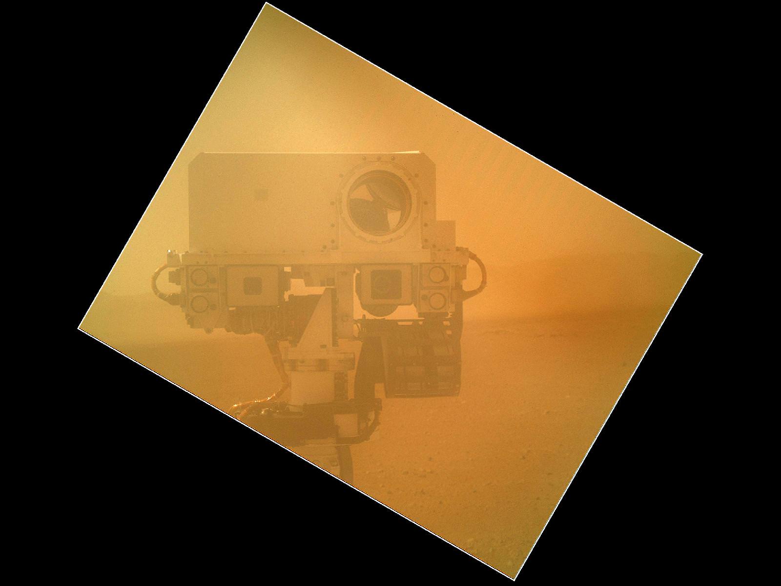
Here’s a picture of the camera itself:

The Mars Hand Lens Imager (MAHLI) camera head. The knife is 88.9 mm (3.5 inches) long. Image credit: Malin Space Science Systems

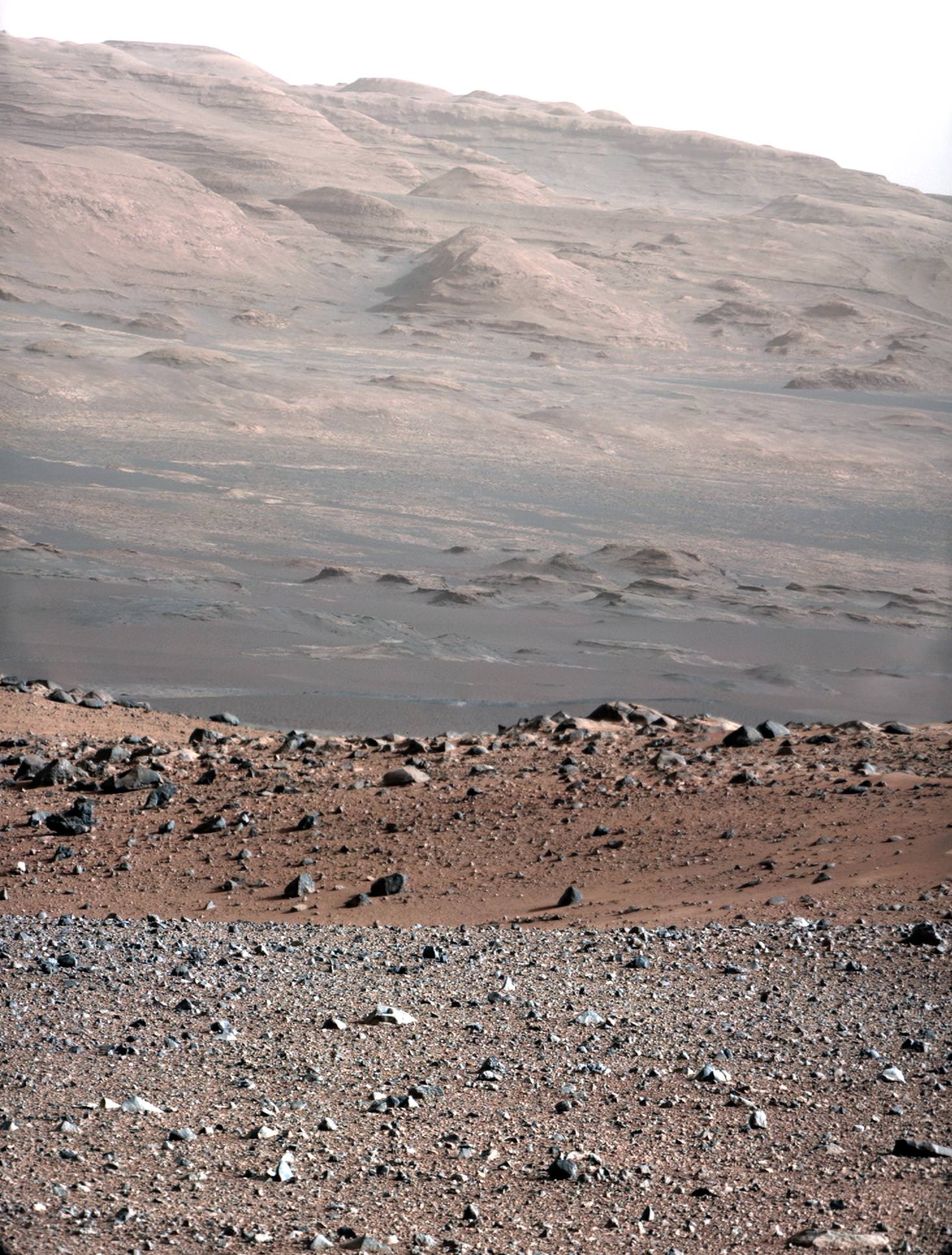
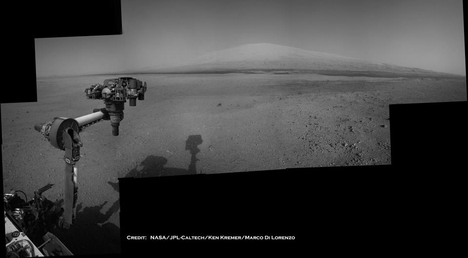
MAHLI is the equivalent of a 2 Megapixel camera. Because MAHLI can focus at infinity, in addition to being able to get microscopic views of surface materials MAHLI can also be used for other purposes, including inspection of areas on the rover or imaging the local landscape — as the images here attest.

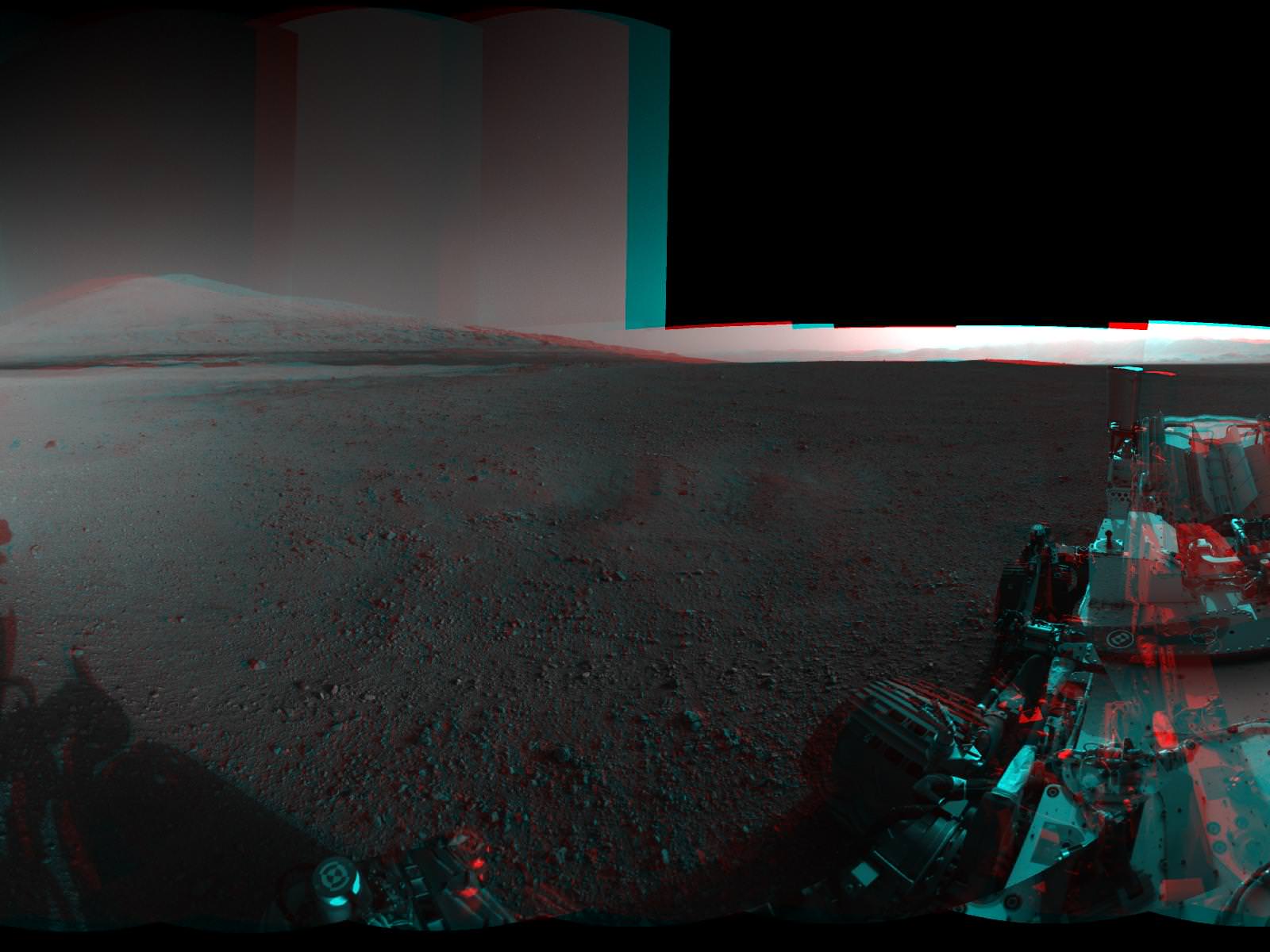
MAHLI can also acquire multiple images of the same feature at different focus positions; additionally look upcoming for 3-D views of selected targets from this camera, since it is located on the robotic arm, it will be relatively easy to move the camera to take two images of the same object from different positions.

Learn more about MAHLI at the Malin Space Science Systems website.

Clay Deposits Don’t Prove Existence of Ancient Martian Lakes

HiRISE image of branching features in the floor of Antoniadi Crater thought to contain clay material. (NASA/JPL/University of Arizona)

In the hunt for evidence of a warmer, wetter past on Mars, clay deposits have been viewed as good indications that stable liquid water existed on its surface for some time — perhaps even long enough to allow life to develop. But new research conducted here on Earth shows that some clays don’t necessarily need lakes of liquid water to form. Instead they can be the result of volcanic activity, which is not nearly so hospitable to life.

A research team led by Alain Meunier of the Université de Poitiers in France studied lavas containing iron and magnesium — similar to ancient clays identified on the surface of Mars — in the French Polynesian atoll of Moruroa. The team’s findings show that the same types of clay outcrops can be caused by the solidifying of water-rich magma in a volcanic environment, and don’t require Earthlike aquatic conditions at all.

The results also correlate to the deuterium-to-hydrogen (D/H) ratio within clays found in Martian meteorites.

Read: Life from Mars Could Have Polluted Earth

“To crystallize, clays need water but not necessarily liquid water,” said Alain Meunier to the Agençe France-Presse (AFP). “Consequently, they cannot be used to prove that the planet was habitable or not during its early history.”

Additionally, the clay deposits found on Mars can be several hundred meters thick, which seems to be more indicative of upwelling magma than interactions with water.

“[This] new hypothesis proposes that the minerals instead formed during brief periods of magmatic degassing, diminishing the prospects for signs of life in these settings,” wrote Brian Hynek from the Department of Geological Sciences at the University of Colorado, in response to the paper by Meunier et al. which was published in the September 9 edition of the journal Nature Geoscience.

This does not necessarily mean that all Martian clays weren’t formed in the presence of water, however. Gale Crater — where NASA’s Curiosity rover is now exploring — could very well have been the site of a Martian lake, billions of years in the past. Clays found there could have been created by water.

Read: Take a Trip to Explore Gale Crater

According to Bethany Ehlmann of the California Institute of Technology, co-author of the study, “there are particular characteristics of texture” to clays formed under different conditions, and “Gale is a different flavor of Mars.”

Perhaps Curiosity will yet discover if Gale’s original flavor was more cool and wet than hot and spicy.

Read more on New Scientist and Cosmos Magazine.

Inset image: Moruroa Atoll (NASA) 

An Inside Look at Curiosity’s Inner Workings

NASA’s Curiosity rover raised robotic arm with drill pointed skyward while exploring Vera Rubin Ridge at the base of Mount Sharp inside Gale Crater - backdropped by distant crater rim. This navcam camera mosaic was stitched from raw images taken on Sol 1833, Oct. 2, 2017 and colorized. Credit: NASA/JPL/Ken Kremer/kenkremer.com/Marco Di Lorenzo

What makes a rover rove? At the very basic level, it comes down to gears, and all the gears have to made very precisely: there’s no going to Mars to fix anything that doesn’t move just right. This video shows how a gear company in Rockford, Illinois made all the gears for the Curiosity rover — created from titanium — putting in extra hours and effort to get everything just right (they also made the gears for the Mars Exploration Rovers).

It also subtly emphasizes how the money spent on space exploration isn’t just stuffed into a rocket and blasted into space. Almost all of Curiosity’s parts were made from different companies in 33 states in the US; the rest came from companies in partner countries, all which employs hundreds, if not thousands, of people.

You have to bet that every person who created or touched any of the parts — big or small — on Curiosity were just as jazzed as the cheering team at JPL when the rover landed successfully. And that Curiosity is working so well and roving around in Gale Crater has to be a a great feeling of accomplishment and satisfaction, too.
Continue reading “An Inside Look at Curiosity’s Inner Workings”

Curiosity Snaps Evocative Self Portrait

Image Cation: Curiosity takes Self Portrait on Sol 32 with the Mars Hand Lens Imager (MAHLI). Image has been rotated up and enhanced by JPL. Credit: NASA/JPL-Caltech/Malin Space Science Systems

Curiosity has snapped an evocative new color self-portrait – and it’s totally unique, being the 1st head shot pose, showing the top of the Remote Sensing Mast (RSM).

You’ll notice it’s a bit dusty ! That’s because it was acquired through the transparent dust cover protecting the high resolution Mars Hand Lens Imager (MAHLI) camera positioned on the turret at the end of Curiosity’s 7 foot (2.1 meter) long robotic arm.

The gorgeous new image was taken on Sol 32 (Sept. 7, 2012) with the dust cover closed over the camera lens and thus provides a taste of even more spectacular views yet to come. The picture beautifully shows the Mastcam, Chemcam and Navcam cameras with the rim of Gale Crater in the background.

The MAHLI image above has been enhanced and rotated – to right side up. See the MAHLI raw image below.

The image was taken as JPL engineers were inspecting and moving the arm turret holding MAHLI and the other science instruments and tools and looking back to image them in turn using the Mast’s cameras.

NASA’s mega Martian rover is pausing for about a week or two at this location reached after driving on Sol 29 (Sept. 2) and will thoroughly check out the robotic arm and several science instruments.

So far Curiosity has driven about 358 feet (109 meters) and is sitting roughly 270 feet from the “Bradbury Landing” touchdown spot as the Martian crow flies.

The car sized robot is about a quarter of the way to Glenelg, the destination of her first lengthy science stop where three different types of geologic terrain intersect and are easily accessible for a detailed science survey using all 10 state of the art instruments including the rock drill and soil sampling mechanisms.

Ken Kremer

Curiosity on the Move! HiRISE Spies Rover Tracks on Mars

The beginning of Curiosity’s journeys. Credit: NASA/JPL-Caltech/Univ. of Arizona

Yes, the Curiosity rover is on the move, evidenced by the rover tracks seen from above by the outstanding HiRISE camera on board the Mars Reconnaissance Orbiter. If you look closely, visible are the rover’s wheels and even the camera mast. While this image’s color has been enhanced to show the surface details better, this is still an amazing view of Curiosity’s activities, displaying the incredible resolving power of the High-Resolution Imaging Science Experiment.

“These are great pictures that help us see context,” said Curiosity mission manager Mike Watkins at a press conference today. “Plus they’re just amazing photos.”

The two “blue” marks (blue is, of course, false color) seen near the site where the rover landed were formed when reddish surface dust was blown away by the rover’s descent stage, revealing darker basaltic sands underneath. Similarly, the tracks appear darker where the rover’s wheels disturbed the top layer of dust.

Below is another great view showing Curiosity’s parachute and backshell in color, highlighting the color variations in the parachute, along with a map of where Curiosity has been and will be going.

Curiosity’s parachute and backshell in color. Credit: NASA/JPL-Caltech/Univ. of Arizona

Map of Curiosity’s travels so far. Credit: NASA/JPL-Caltech/Univ. of Arizona.

This map shows the route driven by NASA’s Mars rover Curiosity overlaid on the HiRISE image, showing where Curiosity has driving through the 29th Martian day, or sol, of the rover’s mission on Mars, which equals Sept. 4, 2012 here on Earth.

The route starts at Bradbury Landing, Curiosity’s landing site. Numbering of the dots along the line indicate the sol numbers of each drive. North is up. The scale bar is 200 meters (656 feet).

By Sol 29, Curiosity had driven at total of 358 feet (109 meters). While scientists say the rover can travel up to a hundred meters a day, the team has been putting the rover through tests of the robotic arms and other instruments.

The first area of real interest that the team wants to study is the Glenelg area, farther east. The science team said the Glenelg region should provide a good target for Curiosity’s first analysis of powder collected by drilling into a rock.

How long will it take to get to Glenelg? It is about 400 meters away, and the rover is about a quarter of the way there so far.

“If you drove every day and didn’t do the context science it would take a couple of weeks to drive to Glenelg, at 30-40 meters a day,” said Matt Robinson, lead engineer for Curiosity’s robotic arm testing and operations. “But I think we will stop and do the context science. My guess is it will be a few weeks before we get to Glenelg.

The drive to Mt. Sharp, which is about 8 km away, will take much longer, months, maybe even a year.

“If we use our full driving mode and do up to one hundred meters a day, and not stop, it would take about 3 months,” said Robinson, “but we might only be driving for one-half to one-third of the time, it depends on how interesting the terrain is along the way.”

This scene shows the surroundings of the location where NASA Mars rover Curiosity arrived on the 29th Martian day, or sol, of the rover’s mission on Mars (Sept. 4, 2012). It is a mosaic of images taken by Curiosity’s Navigation Camera (Navcam) following the Sol 29 drive of 100 feet (30.5 meters). Tracks from the drive are visible in the image. For scale, Curiosity leaves parallel tracks about 9 feet (2.7 meters) apart. At this location on Sol 30, Curiosity began a series of activities to test and characterize the rover’s robotic arm and the tools on the arm.

The panorama is centered to the north-northeast, with south-southwest at both ends.

Image credit: NASA/JPL-Caltech

The view of Curiosity’s surroundings is fascinating to both Mars enthusiasts and the scienctists.
Joy Crisp, the deputy project scientist for the mission said two main things have intrigued her. “One is the Mastcam imaging of Mt. Sharp, seeing structures and layers. The other is the amazing rock textures. Some rocks have light-toned grains mixed in a dark matrix. We need to examine rocks like those more thoroughly.”

“That’s what’s been exciting, to see things we haven’t seen before on Mars,” Crisp added.

See more info and larger versions of these images at this NASA webpage.

Bradbury Landing on Mars Chronicled in 3-D

Image Caption:3-D View from Bradbury Landing- from Navcam cameras.. See the full panorama below. Credit: NASA/JPL-Caltech

Now you can enjoy the thrills of Curiosity’s touchdown site at Bradbury Landing as if you there – chronicled in stunning 3 D !! Check out this glorious 360-degree stereo panorama just released by JPL.

The pano was assembled by JPL from individual right and left eye images snapped by the rover’s mast mounted navigation cameras on sols 2 and 12 of the mission – Aug. 8 and 18, 2012.

So whip out your handy-dandy, red-blue (cyan) anaglyph glasses and start exploring the magnificent home of NASA’s newest Mars rover inside Gale Crater.

Image Caption: Complete 360 degree Panoramic 3-D View from Bradbury Landing by NASA’s Curiosity Mars rover. Credit: NASA/JPL-Caltech

The mosaic shows Curiosity’s eventual mountain destination – Mount Sharp – to its visible peak at the right, as well as the eroded rim of Gale Crater and a rover partial self portrait. Curiosity cannot see the actual summit from the floor of Gale Crater at Bradbury landing.

In about a year, the 1 ton behemoth will begin climbing up the side of Mount Sharp – a layered mountain some 3.4 miles (5.5 kilometers) high that contains deposits of hydrated minerals.

Curiosity will investigate and sample soils and rocks with her powerful suite of 10 state of the art science instruments.

See below JPL’s individual right and left eye pano’s from which the 3-D mosaic was created.

Image Caption: Complete 360 degree Panoramic left eye View from Bradbury Landing by NASA’s Curiosity Mars rover – from Navcam cameras. Credit: NASA/JPL-Caltech

Image Caption: Complete 360 degree Panoramic right eye View from Bradbury Landing by NASA’s Curiosity Mars rover- from Navcam cameras. Credit: NASA/JPL-Caltech

The rover has now departed Bradbury landing and begun her long Martian Trek on an easterly path to Glenelg – her first stop designated for a lengthy science investigation.

Glenelg lies at the intersection of three distinct types of geologic terrain.

So far Curiosity has driven 358 feet (109 meters) and is in excellent health.

Ken Kremer

Curiosity’s Laser Leaves Its Mark

Before-and-after images from Curiosity’s ChemCam  micro-imager show holes left by its million-watt laser (NASA/JPL-Caltech/LANL/CNES/IRAP/LPGN/CNRS)

PEWPEWPEWPEWPEW! Curiosity’s head-mounted ChemCam did a little target practice on August 25, blasting millimeter-sized holes in a soil sample named “Beechey” in order to acquire spectrographic data from the resulting plasma glow. The neat line of holes is called a five-by-one raster, and was made from a distance of about 11.5 feet (3.5 meters).

Sorry Obi-Wan, but Curiosity’s blaster is neither clumsy nor random!

Mounted to Curiosity’s “head”, just above its Mastcam camera “eyes”, ChemCam combines a powerful laser with a telescope and spectrometer that can analyze the light emitted by zapped materials, thereby determining with unprecedented precision what Mars is really made of.

Read: Take a Look Through Curiosity’s ChemCam

For five billionths of a second the laser focuses a million watts of energy onto a specific point. Each of the 5 holes seen on Beechey are the result of 50 laser hits. 2 to 4 millimeters in diameter, the holes are much larger than the laser point itself, which is only .43 millimeters wide at that distance.

ChemCam’s laser allows Curiosity to zap and examine targets up to 23 feet (7 meters) away. Credit: J-L. Lacour/CEA/French Space Agency (CNES)

“ChemCam is designed to look for lighter elements such as carbon, nitrogen, and oxygen, all of which are crucial for life,” said Roger Wiens, principal investigator of the ChemCam team. “The system can provide immediate, unambiguous detection of water from frost or other sources on the surface as well as carbon – a basic building block of life as well as a possible byproduct of life. This makes the ChemCam a vital component of Curiosity’s mission.”

Visit the official ChemCam site for more information.

Mars Trek begins for Curiosity

Image Caption: Martian Soil caked on Curiosity’s right middle and rear wheels after Sol 22 Drive. Credit: NASA/JPL-Caltech

Mars Trek has begun for NASA’s Curiosity rover. The mega rover has departed from her touchdown vicinity at “Bradbury Landing” and set off on a multi-week eastwards traverse to her first science target which the team has dubbed “Glenelg”

Glenelg lies about a quarter mile (400 meters) away and the car-sized rover drove about 52 feet (16 meters) on Tuesday, Aug 28 or Sol 22 of the mission.

The science team selected Glenelg as the first target for detailed investigation because it sits at the intersection of three types of geologic terrain, affording the researchers the chance to get a much more comprehensive look at the diversity of geology inside the Gale Crater landing site.

The Sol 22 drive was the third overall for Curiosity and the farthest so far. At this new location, some 33 feet ( 10 m) from Bradbury Landing , the Mastcam color camera is collecting high resolution images to create a 3 D map of features off in the distance that will aid the rover drivers in planning a safe traverse route.

“This drive really begins our journey toward the first major driving destination, Glenelg, and it’s nice to see some Martian soil on our wheels,” said mission manager Arthur Amador of NASA’s Jet Propulsion Laboratory in Pasadena, Calif. “The drive went beautifully, just as our rover planners designed it.”

In about a week, the science team plans to deploy the 7 ft (2.1 meter) long robotic arm and test the science instruments in the turret positioned at the terminus of the arm.

“We are on our way, though Glenelg is still many weeks away,” said Curiosity Project Scientist John Grotzinger of the California Institute of Technology in Pasadena. “We plan to stop for just a day at the location we just reached, but in the next week or so we will make a longer stop.”

Perhaps in about a year or so, Curiosity will reach the base of Mount Sharp, her ultimate destination, and begin climbing up the side of the 3.6 mile (5.5 km) high mound in search of hydrated minerals that will shed light on the duration of Mars watery past.

The goal is to determine if Mars ever had habitats capable of supporting microbial life in the past or present during the 2 year long primary mission phase. Curiosity is equipped with a sophisticated array of 10 state of the art science instruments far beyond any prior rover.

Ken Kremer

Image Caption: Curiosity Points to her ultimate drive destination – Mount Sharp – with unstowed robotic arm on Aug. 20. This navigation camera (Navcam) mosaic was assembled from images on multiple Sols. Curiosity will search for hydrated minerals using the robotic arm and a neutron detector on the body. Image stitching and processing by Ken Kremer and Marco Di Lorenzo. Featured at APOD on 27 Aug 2012. Credit: NASA/JPL-Caltech/Ken Kremer/Marco Di Lorenzo

Curiosity Sends Back Incredible Hi-Res Views of Mt. Sharp

Wow — what a view! This image, released today, is a high-resolution shot of the Curiosity rover’s ultimate goal: the stratified flanks of Gale Crater’s 3.4-mile (5.5-km) high central peak, Mount Sharp. The image was taken with Curiosity’s 100mm telephoto Mastcam as a calibration test… if views like this are what we can expect from the MSL mission, all I can say is (and I’ve said it before) GO CURIOSITY!


“This is an area on Mount Sharp where Curiosity will go,” said Mastcam principal investigator Michael Malin of Malin Space Science Systems. “Those layers are our ultimate objective. The dark dune field is between us and those layers. In front of the dark sand you see redder sand, with a different composition suggested by its different color. The rocks in the foreground show diversity — some rounded, some angular, with different histories. This is a very rich geological site to look at and eventually to drive through.”

Read more: Take a Trip to Explore Gale Crater

The gravel-strewn region in the foreground is Curiosity’s immediate landing area. Then the ground dips into a low depression called a swale, then rises up again to the edge of a crater that’s rimmed with larger rocks. Quite a bit beyond that (about 2.2 miles/3.7 km away) are fields of dunes composed of darker material, and then the hummocky base of Mount Sharp itself begins to rise up about 3.4 miles (5.5 km) in the distance.

The topmost ridges of Mount Sharp visible above are actually 10 miles (16.2 km) away.

A crop of the full-size image shows a large rock at the foot of a knoll that’s about the same size as Curiosity (which is this big compared to a person and previous rovers):

The rocky mound just behind the boulder in that image is itself about 1,000 feet (300 meters) across and 300 feet (100 meters) high. Gale Crater isn’t a place for a faint-hearted rover!

The colors have been modified from the original image in order to help better discern landforms and differences in surface materials. Here, the images look more like what we’d see under natural Earthly lighting.

Curiosity already is returning more data from the Martian surface than have all of NASA’s earlier rovers combined.

“We have an international network of telecommunications relay orbiters bringing data back from Curiosity,” said JPL’s Chad Edwards, chief telecommunications engineer for NASA’s Mars Exploration Program. “Curiosity is boosting its data return by using a new capability for adjusting its transmission rate.”

See more images from Curiosity here, and keep up to date on the mission at the MSL website here.

“The knowledge we hope to gain from our observation and analysis of Gale Crater will tell us much about the possibility of life on Mars as well as the past and future possibilities for our own planet. Curiosity will bring benefits to Earth and inspire a new generation of scientists and explorers, as it prepares the way for a human mission in the not too distant future.”

– NASA Administrator Charles Bolden in a message transmitted to the Curiosity rover and then back to Earth, August 27, 2012

Images: NASA/JPL-Caltech

Today’s APOD: Curiosity on Mars

Today’s Astronomy Picture of the Day (APOD) features a mosaic put together in part by Universe Today’s Ken Kremer, along with his imaging partner Marco Di Lorenzo, using images sent back from the Curiosity rover. It shows Curiosity’s landing site, Bradbury Landing, with its ultimate destination, Aeolis Mons/Mount Sharp off in the distance. It’s a beautiful and crisp image, which show parts of the rover itself — including the extended robotic arm — and its shadow on Mars. As the APOD editors Robert Nemiroff and Jerry Bonnell say, “If life ever existed on Mars it might well have been here in Gale crater, with the Curiosity rover being humanity’s current best chance to find what remains.”

Congrats to Ken and Marco for being featured on APOD!