Mount Tambora

Mount Tambora

[/caption]
Mount Tambora is an active stratovolcano on Sumbawa island in Indonesia. It once measured 4,300 meters tall, making it one of the tallest mountains in Indonesia. It’s most famous for an enormous eruption in 1815, when the volcano detonated in the most powerful eruption in recorded history. After 150 cubic kilometers were blasted out of the volcano, and the caldera collapsed, Tambora had dropped down to 2,700 meters.

Tambora had only 3 eruptions over the previous 5,000 years, and none were very severe. But in 1812, Mount Tambora became much more active, culminating in a series of eruptions in April, 1815. On the evening of April 10th, 1815, witnesses saw three huge columns of flame rising up from the volcano. Pumice rocks rained down around the volcano, followed by clouds of ash a few hours later.

Geologists have estimated that Mount Tambora erupted with a force of 7 on the Volcanic Explosivity Index; that’s 4 times more powerful than the 1883 Krakatoa eruption. The ash cloud reached Borneo and Sulawasi islands, located 1,300 kilometers away. Historians argue how many deaths caused by the eruption itself, but estimates range from 10,000 killed by the eruption outright to almost 100,000 when you include the disease and starvation after the eruption.

The effects from the Mount Tambora eruption were felt around the world. It released so much sulphur into the atmosphere that the entire planet was cooled. The following year was known as the year without a summer. Snow fell in Quebec in the middle of summer, and persistent fog obscured much of the Northeastern US. Average annual temperatures dropped by 0.4 to 0.7 degrees C. It created the worst famine in the 19th century.

We have written many articles about volcanoes for Universe Today. Here’s an article about Mount St. Helens, and here’s another about Mount Pinatubo.

Want more resources on the Earth? Here’s a link to NASA’s Human Spaceflight page, and here’s NASA’s Visible Earth.

We have also recorded an episode of Astronomy Cast about Earth, as part of our tour through the Solar System – Episode 51: Earth.

Have Astronomers Discovered A New Type of Supernova?

[/caption]

A team of astronomers at the University of Warwick think they’ve finally explained what caused the bizarre transient object SCP 06F6.  By comparing the optical spectrum of SCP 06F6 to that of carbon-rich stars in our own galaxy, the team concludes the sudden outburst was not a low-energy local event but a supernova-like explosion within a cool carbon-rich atmosphere some 2 billion light years away.  If they’re right, it means the collapse of carbon-rich stars may lead to supernovae unlike any yet seen.

First observed in 2006 by U.S. researchers on images from the Hubble Space Telescope, SCP 06F6 flashed suddenly then faded from view over some 120 days.  The U.S. team published their findings in September 2008.  But they had no idea what might cause this outburst.  The event was so unusual, if fact, that astronomers had didn’t know whether SCP 06F6 was located in our own galaxy or at the other end of the universe.  Talk about experimental uncertainty!

The Warwick team noticed the optical spectrum of SCP 06F6 looked a lot like light from cool stars with molecular carbon in their atmosphere.  But to get a close spectral match with SCP 06F6, the team had to apply a redshift to the spectra of the carbon stars to correspond to a rapidly receding object some 2 billion light years away.  The large distance and the sudden appearance of SCP 06F6 suggest the object may be related to the sudden collapse of a carbon-rich star.  If so, it’s a brand new type of supernova.

But questions remain.  SCP 06F6 seems to be alone in space… it has no known visible host galaxy.  And the 120-day time scale of the object’s rise and fall in brightness is four times longer than most Type-II supernovae (the kind caused by the core-collapse of a massive star).

What’s more, X-ray observations by the European satellite XMM-Newton show the object blasts out up to 100 times more X-rays energy than expected from a typical Type-II supernova.

The strong X-ray emission may suggest the star was ripped apart by a black hole rather than exploding on its own.  But according to Boris Gansicke, the lead researcher of Warwick team, “The lack of any obvious host galaxy for SCP 06F6 would imply either a very low black hole mass (if black holes do exist at the centres of dwarf irregular galaxies) or that the black hole has somehow been ejected from its host galaxy. While neither is impossible, this does make the case for disruption by a black hole somewhat contrived.”

The findings were published in the June 1, 2009 issue of Astrophysical Journal Letters.

Source:  University of Warwick

Also see the Universe Today article about the discovery of SCP 06F6

Mauna Kea

Mauna Kea. Image credit: USGS

[/caption]
The shield volcano Mauna Kea is the tallest volcano on Earth, rising to a summit of 4,205 meters above sea level. It’s one of the 5 volcanoes that make up the Big Island of Hawaii. Mauna Kea means “white mountain” in the Hawaiian language because its summit is regularly covered in snow during the winter.

Scientists believe that Mauna Kea began erupting about 1 million years ago. It’s fed by magma from the Hawaiian hotspot; a volcanic vent that continues to pump out magma while the Pacific Plate slowly moves over top of it. This has created a chain of islands thousands of kilometers long called the Hawaiian archipelago. It’s believed that Mauna Kea transitioned from an active volcano to a post-shield stage of volcanic evolution about 200,000 to 250,000 years ago. The last eruption was thought to have occurred about 4000-5000 years ago.

Because of its high altitude, the peak of Mauna Kea is an excellent spot for astronomical observing. The summit of the volcano is above 40% of the Earth’s atmosphere, and 90% of the water vapor, allowing for extremely clear skies. Some of the largest, most powerful telescopes in the world are located atop Mauna Kea, including the Keck observatories, and the Gemini North telescope.

During the winter, Mauna Kea is coated in a thin layer of snow, and there are regions on the mountain where you can ski or snowmobile. And scientists have discovered evidence that large glaciers formed during the last period of world wide glaciation – about 11,000 years ago.

We have written many articles about volcanoes for Universe Today. Here’s an article about Mauna Loa, and here’s an article about Kilauea.

Want more resources on the Earth? Here’s a link to NASA’s Human Spaceflight page, and here’s NASA’s Visible Earth.

We have also recorded an episode of Astronomy Cast about Earth, as part of our tour through the Solar System – Episode 51: Earth.

Mauna Loa

Mauna Loa. Image credit: USGS

[/caption]
Earth’s largest volcano is Mauna Loa, located on the Big Island of Hawaii. Although it only rises 4 km above the surface of the Pacific Ocean, that’s just the tip of the iceberg. Mauna Loa descends another 5 km down to the sea floor, which has been pushed down another 8 km by the mass of Mauna Loa. When you add that all up, the summit of Mauna Loa is 17 km above its base. It’s not the tallest volcano on Earth, though, it’s actually 37 meters shorter than Mauna Kea.

Half of the island of Hawaii is made up by Mauna Loa, and it amounts to 85 percent of all the other Hawaiian islands combined. Scientists believe that Mauna Loa has been erupting for at least 700,000 years, and may have emerged above sea level 400,000 years ago. Furthermore, Mauna Loa is one of the world’s most active volcanoes having erupted 33 times since detailed records began in 1843. Its most recent eruption was in 1984, and it’s almost certain to erupt again in the near future.

As with all of the Hawaiian volcanoes, Mauna Loa gets its magma from the Hawaiian hotspot. This is a chamber of magma that has created all the islands in the Hawaiian archipelago. The slow movement of the Pacific Plate has created a succession of volcanic islands that stretch thousands of km across the ocean. Nearby Mauna Kea is dormant, Mauna Loa is active and the smaller Kilauea is in an almost constant state of eruption.

Mauna Loa is a shield volcano. This means it has wide, gently sloping flanks. The basalt lava that erupts out of Mauna Loa and the other Hawaiian Islands has a high viscosity, and can flow for dozens of kilometers. Explosive eruptions on shield volcanoes are rare. Scientists have detected a magma chamber about 3 km below the surface of Mauna Loa, and smaller chambers beneath rift zones on the volcano’s flanks.

We have written many articles about volcanoes for Universe Today. Here’s an article about Kilauea, and here’s an article about Krakatoa.

Want more resources on the Earth? Here’s a link to NASA’s Human Spaceflight page, and here’s NASA’s Visible Earth.

We have also recorded an episode of Astronomy Cast about Earth, as part of our tour through the Solar System – Episode 51: Earth.

Mount Pinatubo

Mount Pinatubo is an active stratovolcano on the island of Luzon in the Philippines, and the site of one of the most powerful recent eruptions. In June 1991, the volcano produced the second largest terrestrial eruption of the 20th century (after Novarupta), and the largest eruption in living memory. At least 800 people lost their lives in the eruption, but this was lower than it could have been because of an organized evacuation effort.

Pinatubo is located in the Cabusilan Mountain range, located on the west coast of the Island of Luzon. It’s a stratovolcano made up of successive layers of andesite and dacite. Its richly forested slopes were home to several thousand indigenous people. Before the eruption, it rose to an elevation of 1745 meters, but now it’s only 1485 meters tall.

Scientists had many warnings that Pinatubo was about to erupt, and this allowed such a thorough evacuation. On July 16, 1990, a magnitude 7.8 earthquake struck about 100 km north of Pinatubo. And then in March/April 1991, molten rock was detected rising to the surface from more than 32 kilometers beneath Pinatubo. This triggered more small earthquakes through April, May and early June.

On June 12, 1991, millions of cubic meters of magma reached the surface, beginning several days of eruptions. Even more magma reached the surface on June 15th, ejecting more than 5 cubic kilometers of material. An ash cloud rose 35 kilometers into the air, covering the surrounding region in meters of ash. Dangerous pyroclastic flows of hot ash, rock and water surged down the sides of the volcano, destroying everything in their path. The huge eruption gouged out a caldera 2.5 km across.

The eruption was so significant that the ash darkened the atmosphere, and caused worldwide temperatures to drop by 0.5 degrees C.

We have written many articles about volcanoes for Universe Today. Here’s an article about Mount St. Helens, and here’s an article about Krakatoa.

Want more resources on the Earth? Here’s a link to NASA’s Human Spaceflight page, and here’s NASA’s Visible Earth.

We have also recorded an episode of Astronomy Cast about Earth, as part of our tour through the Solar System – Episode 51: Earth.

Mount St. Helens

Eruption of Mount St. Helens

[/caption]
The most powerful and devastating volcanic eruption in the history of the United States was the explosion of Mount St. Helens. This active stratovolcano, located in Skamania County, Washington detonated on May 18, 1980, killing 57 people, destroying hundreds of homes, and flattening hundreds of square kilometers of forest. The eruption tore off the top of the mountain, reducing its height from 2,950 meters to 2,550 meters.

Mount St. Helens is just one volcano in the Cascade Range of mountains that stretch down the west coast of North America. There are many other famous volcanoes in this region, like Mount Ranier, Mount Hood, and Mount Shasta. Helens is a large eruptive cone made up of several layers of lava rock interlaced with ash, pumice and other deposits. There are layers of basalt and andesite, and several domes of dacite lava have broken through.

Scientists believe that Mount St. Helens started forming about 40,000 years ago, and it’s considered the most active volcano in the Cascade Range. Before its eruption, St. Helens was the 5th-highest peak in Washington state; it was nicknamed the Mount Fuji of America. It measures about 10 km across the base and rose about 1,500 meters above the surrounding landscape.

And so, on May 18, 1980, Mount St. Helens erupted catastrophically, after nearly 2 months of local earthquakes and steam eruptions – scientists measured more than 10,000 minor earthquakes leading up to the eruption. But it was a magnitude 5.1 earthquake on May 18th that caused the volcano’s bulging north flank to slide away in the largest landslide in recorded history. This released a huge blast of hot gas, steam and rock debris that swept downhill from the summit. This pyroclastic flow melted snow and ice on the mountain, which added to the torrent of material streaming down the river valleys leading from the volcano. A plume of ash rose 19 kilometers into the air, covering 57,000 square kilometers of the Western United States.

Mount St. Helens is still active, and scientists have discovered dozens of extrusions of thick, pasty lava. A new dome is taking shape. It’s now about 1,100 meters in diameter and 250 meters tall.

We have written many articles about volcanoes for Universe Today. Here’s an article about Kilauea in Hawaii, and here’s an article about Krakatoa.

Want more resources on the Earth? Here’s a link to NASA’s Human Spaceflight page, and here’s NASA’s Visible Earth.

We have also recorded an episode of Astronomy Cast about Earth, as part of our tour through the Solar System – Episode 51: Earth.

References:
http://vulcan.wr.usgs.gov/Volcanoes/MSH/May18/summary_may18_eruption.html
http://vulcan.wr.usgs.gov/Volcanoes/MSH/Publications/Bulletin1859/eruption_may18_1980.html

Kilauea Volcano

Lava fountain in Hawaii.

[/caption]
The Hawaiian Island chain is a long string of islands that actually stretches for thousands of km. All of these islands were formed by the movement of the Pacific plate above a volcanic hotspot. As the plate is constantly slowly moving, it allowed volcanic islands to form and then carried them away so they would become extinct. There are 5 shield volcanoes on the Big Island of Hawaii, with Kilauea being the newest and most active.

Kilauea is located on the Eastern edge of the Big Island of Hawaii. It rises only 1,247 km above sea level; a fraction of its neighbor Mauna Loa, which rises to 4,169 km. It’s classified as part of a family of low, broad volcanoes known as shield volcanoes. The basaltic lava that erupts out of shield volcanoes has a low viscosity which can flow for dozens of kilometers. While the other volcanoes on the island are extinct or dormant, Kilauea is in an almost constant state of eruption.

Scientists used to think that Kilauea was a satellite volcano of the larger Mauna Loa, but better research has shown that Kilauea has its own magma plumbing system, starting more than 60 km below the surface of the Earth. Kilauea has almost continuous activity during the 19th century, and there were 34 eruptions since 1952. In January 1983, eruptions began along the east rift zone and haven’t stopped since.

Kilauea is one of the most accessible volcanoes in the world. You can drive right up to it, park, and walk down a short trail to peer into the volcano crater. There’s even a lodge on the ridge that gives an amazing view of the volcano. One of the best ways to view Kilauea is by boat. Tours will take visitors just offshore, where hot lava is pouring out of Kilauea and into the Pacific Ocean. This creates huge plumes of steam.

The inhabitants of the Hawaiian Islands believed that the goddess of volcanoes, Pele, lived in Kilauea. They thought that eruptions happened when their goddess was angry, and they developed many tribal chants to try and calm her down. Several unique lava formations are named after her, like Pele’s tears (small drops of lava that cooled in mid air during an eruption), and Pele’s hair (strands of volcanic glass).

We have written many articles about volcanoes for Universe Today. Here’s an article about Mount Vesuvius, and here’s an article about Mount Etna.

Want more resources on the Earth? Here’s a link to NASA’s Human Spaceflight page, and here’s NASA’s Visible Earth.

We have also recorded an episode of Astronomy Cast about Earth, as part of our tour through the Solar System – Episode 51: Earth.

Reference:
USGS Volcano Information Page: Kilauea

Krakatoa

Illustration of the Krakatoa eruption.

[/caption]
Perhaps the most famous volcanic eruption in recent history is the explosion of the volcano Krakatoa in 1883. On August 27 a series of four explosions almost entirely destroyed the island. People as far away as Perth in Western Australia could hear the detonation, and it’s estimated that 120,000 people died from the eruption. In fact, the entire climate of Earth was affected for several years after the eruption, as global temperatures dipped for 5 years.

What’s left of Krakatoa is a small group of islands located in the Sunda Strait, which divides Sumatra from the Island of Java. It’s located directly above the subduction zone of the Eurasian Plate and the Indo-Australian Plate, where the plates make a change in direction. It’s believed that the volcano’s caldera collapsed in 416 AD, forming a 7-km wide caldera. The remnants of this eruption formed Verlaten and Lang Islands. Three volcanoes (Rakata, Danan and Perbuwatan) came together to form the pre-1883 Krakatau island.

Krakatau was made up of one or more stratovolcanoes that went through 5 major periods. The first was an early growth phase, followed by the formation of the caldera. Then the caldera collapsed, and was destroyed during the 1883 eruption. A new growth phase began in December 27, and even now Krakatoa is growing by more than 12 cm/year.

The destruction of Krakatoa began on May 20, 1883 when a mild ash and steam eruptions started up. There were similar eruptions for about 3 months, and at times several vents were erupting at the same time. On August 11, large ash columns rose from the main crater of Perbuwatan. These small eruptions intensified over time, leading to the August 27th explosion that caused the collapse of the caldera.

Although the eruption of Krakatau was devastating, scientists think that many people lost their lives from the giant tsunami generated by the eruption. The largest wave reached 40 meters and killed around 34,000 people. In one case, a ship was carried 2.5 kilometers inland and dumped into the forest.

Scientists measuring the strength of volcanic eruptions using a scale called the Volcanic Explosivity Index (VEI). The eruption at Krakatau measured VEI 6 on the scale, and ejected 16 cubic kilometers of material. Anything within 16 km was covered with 16 meters of ash. Even towns located more than 450 km away were coated with a few cm of ash.

We have written many articles about volcanoes for Universe Today. Here’s an article on Mount Etna, and here’s an article on Mount Vesuvius.

Want more resources on the Earth? Here’s a link to NASA’s Human Spaceflight page, and here’s NASA’s Visible Earth.

We have also recorded an episode of Astronomy Cast about Earth, as part of our tour through the Solar System – Episode 51: Earth.

References:
http://vulcan.wr.usgs.gov/Volcanoes/Indonesia/description_krakatau_1883_eruption.html
http://hvo.wr.usgs.gov/volcanowatch/2003/03_05_22.html

Astronomers Observe Formation of Largest Bound Structures in the Universe

The massive radio galaxy PKS 0745-191, for which the cluster is named, appears at the center of this Hubble Space Telescope image. The picture forms the inset in the Suzaku image above.

[/caption]

An international team of astronomers has mapped the density and temperature of X-ray-emitting gas in the outskirts of a distant galaxy cluster.   The results, obtained with the orbiting Japanese X-ray telescope Suzaku, give the first complete X-ray view of a galaxy cluster, and provide insight into how such clusters come together.

“These Suzaku observations are exciting because we can finally see how these structures, the largest bound objects in the universe, grow even more massive,” said Matt George, the study’s lead author at the University of California, Berkeley.

The team trained Suzaku’s X-ray telescopes on the massive galaxy cluster PKS 0745-191, which lies 1.3 billion light-years away in the southern constellation Puppis.  Between May 11 and 14, 2007, Suzaku acquired five images of the million-degree gas that permeates the cluster.

The X-ray images of the cluster helped astronomers measure the temperature and density of the gas.  These provide clues about the gas pressure and cluster’s total mass.  The hottest, densest gas lies near the cluster’s center, while gas temperature and density steadily decline away from the center.

Astronomers believe the gas in the inner part of a galaxy cluster has settled into an ordered “relaxed” state in equilibrium with the cluster’s gravity.  But in the outer regions, where galaxies first begin a billion-year plunge towards the cluster’s center, the gas remains in a disordered state because it’s still falling inward.

“Clusters are the most massive, relaxed objects in the universe, and they are continuing to form now,” said team member Andy Fabian at the Cambridge Institute of Astronomy in the UK.

For the first time, this study shows X-ray emission and gas density and temperature out to the region where the gas is disordered, and where the cluster continues to assemble.

“It gives us the first complete X-ray view of a cluster of galaxies”, said Fabian.

This Suzaku image shows X-ray emission from hot gas throughout the galaxy cluster PKS 0745-191. Brighter colors indicate greater X-ray emission. The circle is 11.2 million light-years across and marks the region where cold gas is now entering the cluster. Inset: A Hubble optical image of the cluster's central galaxies is shown at the correct scale.

In PKS 0745-191, the gas temperature peaks at 164 million degrees Fahrenheit (91 million C) about 1.1 million light-years from the cluster’s center. The temperature declines smoothly with distance, dropping to 45 million F (25 million C) more than 5.6 million light-years from the center.

To accurately measure X-ray emission at the cluster’s edge requires detectors with exceptionally low background noise.  Suzaku has advanced X-ray detectors, and it lies in a low-altitude orbit near the Earth’s magnetic field, which protects the observatory from energetic particles from the sun and beyond.

“With more Suzaku observations in the outskirts of other galaxy clusters, we’ll get a better picture of how these massive structures evolve,” added George.

Suzaku (Japanese for “red bird of the south”) was launched on July 10, 2005. The observatory was developed at the Japanese Institute of Space and Astronautical Science (ISAS), which is part of the Japan Aerospace Exploration Agency (JAXA), in collaboration with NASA and other Japanese and U.S. institutions.

The results were published in the May 11 edition of the Monthly Notices of the Royal Astronomical Society.

Source: NASA

Weekend SkyWatcher’s Forecast – May 29-31, 2009

Greetings, fellow SkyWatchers! Have you been watching the lovely crescent Moon as it climbs higher each night? What a beauty! With warmer nights in the northern hemisphere and cooler evenings bringing clear, deep views to the south – why not spend some time stargazing? We’ve got some great lunar features lined up for you to help you along with your lunar club challenges – as well as a bright galaxy and an interesting variable star. Time to dust off your optics and head out into the night…

madlerFriday, May 29, 2009 – Today we begin with the 1794 birth on this date of Johann Heinrich von Madler who, along with Wilhelm Beer, published the most complete map up to that time of the Moon, Mappa Selenographia. How fitting, then, that we should visit the Moon tonight! We’re going in search of another Lunar Club Challenge that will prove difficult because you’ll be working without a map.

Relax! This will be much easier than you think. Starting at Mare Crisium, move along the terminator to the north following the chain of craters until you identify a featureless oval that looks similar to Plato seen on a curve. This is Endymion, and if you can’t spot it tonight don’t worry. We’ll look in the days ahead at some features that will point you to it!

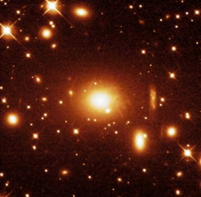
Since tonight will be our last chance to galaxy hunt for a while, let’s take a look at one of the brightest members of the Virgo Cluster – M49 (RA 12 29 46 Dec +07 59 59). Located about 8 degrees northwest of Delta Virginis, and almost directly between a pair of 6th magnitude stars, the giant elliptical M49 holds the distinction of being the first galaxy in the Virgo Cluster to be discovered – and just the second beyond our local group.

m49

At magnitude 8.5, this type E4 galaxy will appear as an evenly illuminated egg shape in almost all scopes, and as a faint patch in binoculars. Although a possible supernova event occurred in 1969, don’t confuse the foreground star noted by Herschel with something new! Most telescopes won’t be able to pick this region apart – especially with the Moon so near – but there are also many fainter companions near M49, including NGC 4470. A sharp-eyed observer named Halton Arp noticed them and listed them as ‘‘Peculiar Galaxy 134 ’’ – one with ‘‘fragments’’!

leonovSaturday, May 30, 2009 – Today we begin with the 1423 birth of Georg von Peuerbachon this date, a follower of Ptolemy’s astronomy. Georg calculated eclipses; observed Halley’s Comet before it was so named; and created astronomical instruments. Following Georg nearly half a millennium later was Hannes Alfven, born in 1908. Alfven’s life work was plasma and its electric and magnetic forces. Lastly, we have Aleksei Arkhipovich Leonov, who was born in 1934. Leonov was the first man to climb out of a spacecraft (the Voskhod II ) and into space. He was the first true ‘‘astrophotographer’’ as he filmed for 10 minutes while orbiting!

Tonight let’s take our own journey to the Moon and look at a beautiful series of craters – Fabricius, Metius, and Rheita.

fabricius

Bordered on the south by shallow Jannsen, Lunar Club Challenge Fabricius is a 78-kilometer diameter crater highlighted by two small interior mountain ranges. To its northeast is Metius, which is slightly larger, with a diameter of 88 kilometers. Look carefully at the two. Metius has much steeper walls, while Fabricius shows differing levels and heights. Metius’s smooth floor also contains a very prominent B crater on the inside of its southeast crater wall. Further northeast is the lovely Rheita Valley, which stretches almost 500 kilometers and appears more like a series of confluent craters than a fault line. The 70-kilometer diameter crater Rheita is far younger than this formation
because it intrudes upon it. Look for a bright point inside the crater, its central peak.

While the Moon is still west, let’s have a look at telescopic star W Virginis located about 3.5 degrees southwest of Zeta (RA 13 26 02 Dec -03 22 43). This 11,000 light-year-distant Cepheid-type variable is, oddly enough, a Population II lying outside the galactic plane. This expanding and contracting star goes through its changes in a little over 17 days and will vary between 8th and 9th magnitude. Although it is undeniably a Cepheid, it breaks the rules by being both out of place in the cosmic scheme and displaying abnormal spectral qualities!

abbottSunday, May 31, 2009 – Today we begin with noting the 1872 birth on this date of Charles Greeley Abbot, who may very well have been the first astronomer to suspect that the radiation from the Sun might vary over time, and thus it was technically a variable star. When Abbot became the director of the Smithsonian Astrophysical Observatory (SAO), the SAO established a network of solar radiation observatories around the world. After many decades of study, a connection was made between solar variations and weather on Earth.

Tonight the Moon will be our companion. Now well risen above atmospheric disturbance, this would be a great time to have a look for several Lunar Club Challenges you might have missed. Most prominent of all will be two craters to the north named Atlas and Hercules. The easternmost Atlas was named for the mythical figure who bore the weight of the world on his shoulders. The crater spans 87 kilometers and contains a vivid Y-shaped rima in the interior basin. Western Hercules is considerably smaller at 69 kilometers in diameter and shows a deep interior crater, called G. Power up, and look for the tiny E crater, which marks the southern crater rim. North of both is another unusual feature that many observers miss. It is a much more eroded and far older crater showing only a basic outline; this crater is known as Atlas E.

Since we’re here, let’s take a crater walk and see how many features we can identify. . . Good luck and clear skies!

may_moon_map

Atlas region: (1) Mare Humboldtianum, (2) Endymion, (3) Atlas, (4) Hercules, (5) Chevalier, (6) Shuckburgh, (7) Hooke, (8) Cepheus, (9) Franklin, (10) Berzelius, (11) Maury, (12) Lacus Somniorum, (13) Daniel, (14) Grove, (15) Williams, (16) Mason, (17) Plana, (18) Burg, (19) Lacus Mortis, (20) Baily, (21) Atlas E, (22) Keldysh, (23) Mare Frigoris, (24) Democritus, (25) Gartner, (26) Schwabe, (27) Thales, (28) Strabo, (29) de la Rue, and (30) Hayn.

Until next week? Ask for the Moon, but keep on reaching for the stars!

This week’s awesome images are Johann Heinrich von Madler (historical image), M49 (credit—Palomar Observatory, courtesy of Caltech), Aleksey Arkhipovich Leonov (archival image), Fabricius, Metius, and Rheita (credit—Alan Chu), Charles Greeley Abbot (historical image) and Atlas region (credit—Greg Konkel, annotations by Tammy Plotner). We thank you!