1981 Climate Change Predictions Were Eerily Accurate

The disintegrated Wilkins Ice Shelf in April 2009. (Chelys/EOSnap)

[/caption]

A paper published in the journal Science in August 1981 made several projections regarding future climate change and anthropogenic global warming based on manmade CO2 emissions. As it turns out, the authors’  projections have proven to be rather accurate — and their future is now our present.

The paper, written by a team of atmospheric physicists led by the now-controversial James Hansen at NASA’s Institute for Space Studies at Goddard Space Flight Center, was recently rediscovered by researchers Geert Jan van Oldenborgh and Rein Haarsma from the Royal Netherlands Meteorological Institute (KNMI). Taking a break from research due to illness, the scientists got a chance to look back through some older, overlooked publications.

“It turns out to be a very interesting read,” they noted in their blog on RealClimate.org.

Even though the paper was given 10 pages in Science, it covers a lot of advanced topics related to climate — indicating the level of knowledge known about climate science even at that time.

“The concepts and conclusions have not changed all that much,” van Oldenborgh and Haarsma note. “Hansen et al clearly indicate what was well known (all of which still stands today) and what was uncertain.”

Within the paper, several graphs note the growth of atmospheric carbon dioxide, both naturally occurring and manmade, and projected a future rise based on the continued use of fossil fuels by humans. Van Oldenborgh and Haarsma overlaid data gathered by NASA and KNMI in recent years and found that the projections made by Hansen et al. were pretty much spot-on.

If anything, the 1981 projections were “optimistic”.

Data from the GISS Land-Ocean Temperature Index fit rather closely with the 1981 projection (van Oldenborgh and Haarsma)

Hansen wrote in the original paper:

“The global temperature rose by 0.2ºC between the middle 1960’s and 1980, yielding a warming of 0.4ºC in the past century. This temperature increase is consistent with the calculated greenhouse effect due to measured increases of atmospheric carbon dioxide. Variations of volcanic aerosols and possibly solar luminosity appear to be primary causes of observed fluctuations about the mean rend of increasing temperature. It is shown that the anthropogenic carbon dioxide warming should emerge from the noise level of natural climate variability by the end of the century, and there is a high probability of warming in the 1980’s. Potential effects on climate in the 21st century include the creation of drought-prone regions in North America and central Asia as part of a shifting of climate zones, erosion of the West Antarctic ice sheet with a consequent worldwide rise in sea level, and opening of the fabled Northwest Passage.”

Now here we are in 2012, looking down the barrel of the global warming gun Hansen and team had reported was there 31 years earlier. In fact, we’ve already seen most of the predicted effects take place.

“Drought-prone regions” are receiving less rainfall, the Antarctic ice has begun to crack and crumble and bowhead whales are using the Northwest Passage as a polar short-cut. 

The retreat of Pedersen Glacier in Alaska. Left: summer 1917. Right: summer 2005. Source: The Glacier Photograph Collection, National Snow and Ice Data Center/World Data Center for Glaciology.

And that’s not the only prediction that seems to have uncannily come true.

“In light of historical evidence that it takes several decades to complete a major change in fuel use, this makes large climate change almost inevitable,” Hansen et al wrote in anticipation of the difficulties of a global shift away from dependence on carbon dioxide-emitting fossil fuels.

“CO2 effects on climate may make full exploitation of coal resources undesirable,” the paper concludes. “An appropriate strategy may be to encourage energy conservation and develop alternative energy sources, while using fossil fuels as necessary during the next few decades.”

(Watch a TED talk by James Hansen on “Why I Must Speak Out About Climate Change”)

As the “next few decades” are now, for us, coming to a close, where do we stand on the encouragement of energy conservation and development on alternative energy sources?  Sadly the outlook is not as promising as it should be, not given our level of abilities to monitor the intricate complexities of our planet’s climate and to develop new technologies. True advancement will rely on our acceptance that a change is in fact necessary… a hurdle that is proving to be the most difficult one to clear.

Read van Oldenborgh and Haarsma’s blog post here, and see the full 1981 paper “Climate Impact of Increasing Carbon Dioxide” here. And for more news on our changing climate, visit NASA’s Global Climate Change site.

Tip of the anthropogenically-warmer hat to The Register.

NASA Jets Buzz The Capitol

Twin NASA T-38s flew over the U.S. Capitol on April 5, 2012. (NASA/Paul E. Alers)

[/caption]

Earlier today, Thursday, April 5,  two NASA T-38 jets passed over the Washington, DC metropolitan area, during planned training and photographic  flights. The photo above by Paul E. Alers shows the jets flying over the U.S. Capitol building.

See this and more images from the flyby on NASA HQ Photo’s Flickr page here.

Made by Northrop and powered by two afterburning General Electric J85 engines, a T-38 can fly supersonic up to Mach 1.6 and soar above 40,000 feet, about 10,000 feet higher than airliners typically cruise. The plane can wrench its pilots through more than seven Gs, or seven times the force of gravity.

A pair of T-38s fly in formation over Galveston Beach in Texas, showing some of the aerobatic abilities of the T-38. (Photo courtesy of Story Musgrave)

“The T-38 is a great aircraft for what we need at NASA because it’s fast, it’s high-performance and it’s very simple,”  says Terry Virts, who flew as the pilot of STS-130 aboard shuttle Endeavour. “It’s safe and it’s known. So compared to other airplanes, it’s definitely one of the best.”

Today the  T-38 training jets flew approximately 1,500 feet above Washington between 9:30 and 11 a.m. EDT. The April 5 flights were intended to capture photographic imagery.

Check out a great article about NASA’s T-38s here.

Could There Be Life In Them Thar Pits?

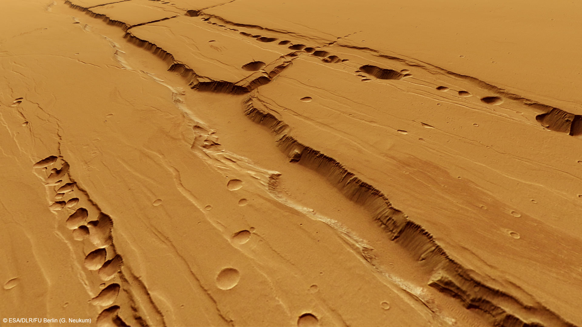
Computer-generated perspective of the Tractus Catene pit chains. Credit: ESA/DLR/FU Berlin (G. Neukum)

[/caption]

Recent images from ESA’s Mars Express spacecraft reveal long rows of crater-like depressions lining the flanks of ancient Martian volcanoes located in the planet’s vast Tharsis region. Rather than being the result of impact events, these “pit chains” were likely caused by underground lava flows — and could be a prime location for look for life.

Like similar features found on Earth, lava tubes on Mars are the result of rivers of magma that carved channels beneath the surface. When these channels empty out, a hollow tube is left. If the roof of a particularly large tube is near the surface the roof can eventually collapse, creating a surface depression… or, in some cases, opening up to the surface entirely.

Even though volcanism on Mars isn’t currently active — the last eruptions probably took place at least over a million years ago — the features left by volcanic activity are still very much present today and likely well-preserved beneath the Martian surface.

Shielded from harsh solar and cosmic radiation, the interior of such lava tubes could provide a safe haven for microbial life — especially if groundwater had found its way inside at some point.

Even though the surface of Mars can receive 250 times the radiation levels found on Earth, the layers of soil and rock surrounding the tubes can provide adequate protection for life, whether it be ancient Martian microbes or future explorers from Earth.

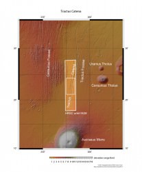
A wider image of the Tractus Catena region showing the large shield volcano Ascraeus Mons. Credits: ESA/DLR/FU Berlin (G. Neukum)

Of course, water and protection from radiation aren’t the only factors necessary for life. There also needs to be some source of heat. Fortunately, the pit chains imaged by Mars Express happen to be within one of the most volcano-laden areas of the Red Planet, a region called the Arcadia quadrangle. Within this area exist some of the largest volcanoes on Mars — and the Tractus Catena pits are located right in the middle of them.

If a heat source were ever to have been beneath the surface of Mars, there would be a good chance it would have been here.

And if our own planet is any measure of such things, where there’s heat and water there is often some form of life — however extreme the conditions may be.

“I’d like to see us land ON a volcano,” Dr. Tracy Gregg, a volcanologist with the University of Buffalo, had once told Universe Today back in 2004. “Right on the flanks. Often the best place to look for evidence of life on any planet is near volcanoes.”

“That may sound counterintuitive, but think about Yellowstone National Park , which really is nothing but a huge volcano,” Gregg elaborated. “Even when the weather in Wyoming is 20 below zero, all the geysers, which are fed by volcanic heat, are swarming with bacteria and all kinds of happy little things cruising around in the water. So, since we think that the necessary ingredients for life on Earth were water and heat, we are looking for the same things on Mars.”

As far as any remaining geothermal activity still happening beneath the Martian surface?

“I strongly suspect there are still molten (or at least mushy) magma bodies beneath the huge Tharsis volcanoes,” Gregg had said. (Read the full article here.)

On Earth, lava tubes, caves and underground spaces of all kinds harbor life, often specialized forms that are found no place else. Could this be (or have once been) the case on Mars as well? Only future exploration will tell. Until then, places like Tractus Catena will remain on scientists’ short list of places to look.

Read more on the ESA website here.

Polar Telescope Casts New Light On Dark Energy And Neutrino Mass

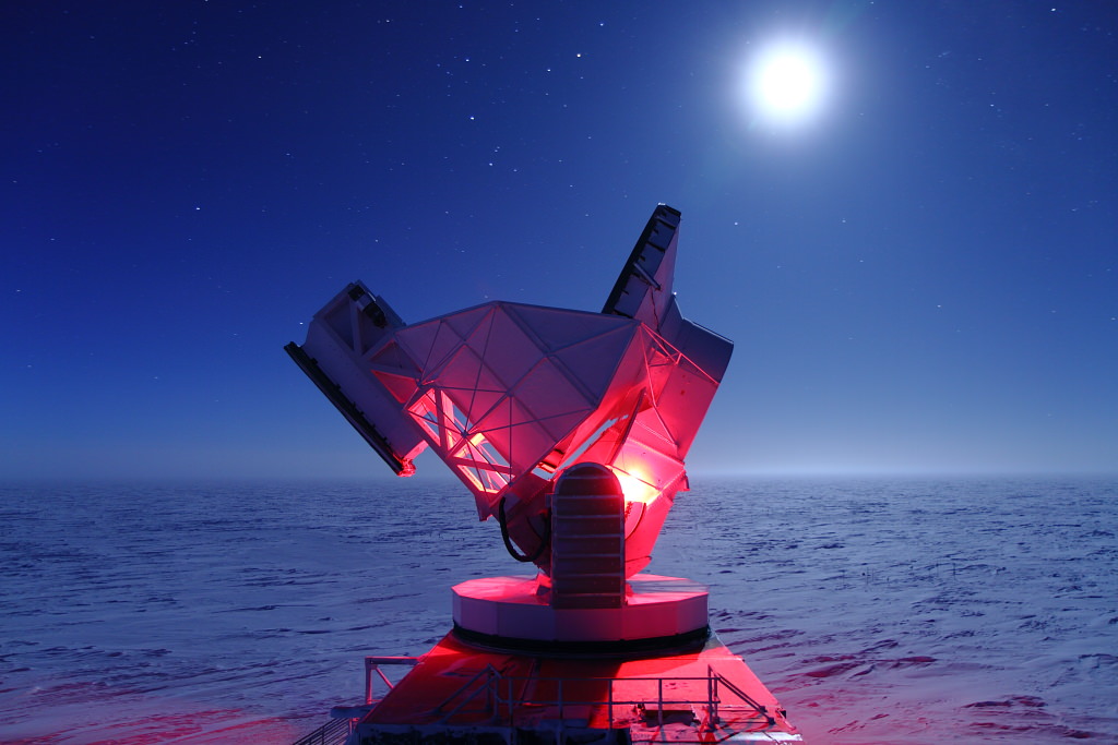
The 10-meter South Pole Telescope in Antarctica at the Amundsen-Scott Station. (Daniel Luong-Van, National Science Foundation)

[/caption]

Located at the southermost point on Earth, the 280-ton, 10-meter-wide South Pole Telescope has helped astronomers unravel the nature of dark energy and zero in on the actual mass of neutrinos — elusive subatomic particles that pervade the Universe and, until very recently, were thought to be entirely without measureable mass.

The NSF-funded South Pole Telescope (SPT) is specifically designed to study the secrets of dark energy, the force that purportedly drives the incessant (and apparently still accelerating) expansion of the Universe. Its millimeter-wave observation abilities allow scientists to study the Cosmic Microwave Background (CMB) which pervades the night sky with the 14-billion-year-old echo of the Big Bang.

Overlaid upon the imprint of the CMB are the silhouettes of distant galaxy clusters — some of the most massive structures to form within the Universe. By locating these clusters and mapping their movements with the SPT, researchers can see how dark energy — and neutrinos — interact with them.

“Neutrinos are amongst the most abundant particles in the universe,” said Bradford Benson, an experimental cosmologist at the University of Chicago’s Kavli Institute for Cosmological Physics. “About one trillion neutrinos pass through us each second, though you would hardly notice them because they rarely interact with ‘normal’ matter.”

If neutrinos were particularly massive, they would have an effect on the large-scale galaxy clusters observed with the SPT. If they had no mass, there would be no effect.

The SPT collaboration team’s results, however, fall somewhere in between.

Even though only 100 of the 500 clusters identified so far have been surveyed, the team has been able to place a reasonably reliable preliminary upper limit on the mass of neutrinos — again, particles that had once been assumed to have no mass.

Previous tests have also assigned a lower limit to the mass of neutrinos, thus narrowing the anticipated mass of the subatomic particles to between 0.05 – 0.28 eV (electron volts). Once the SPT survey is completed, the team expects to have an even more confident result of the particles’ masses.

“With the full SPT data set we will be able to place extremely tight constraints on dark energy and possibly determine the mass of the neutrinos,” said Benson.

“We should be very close to the level of accuracy needed to detect the neutrino masses,” he noted later in an email to Universe Today.

The South Pole Telescope's unique position allows it to watch the night sky for months on end. (NSF)

Such precise measurements would not have been possible without the South Pole Telescope, which has the ability due to its unique location to observe a dark sky for very long periods of time. Antarctica also offers SPT a stable atmosphere, as well as very low levels of water vapor that might otherwise absorb faint millimeter-wavelength signals.

“The South Pole Telescope has proven to be a crown jewel of astrophysical research carried out by NSF in the Antarctic,” said Vladimir Papitashvili, Antarctic Astrophysics and Geospace Sciences program director at NSF’s Office of Polar Programs. “It has produced about two dozen peer-reviewed science publications since the telescope received its ‘first light’ on Feb. 17, 2007. SPT is a very focused, well-managed and amazing project.”

The team’s findings were presented by Bradford Benson at the American Physical Society meeting in Atlanta on April 1.

Read more on the NSF press release here.

Is Earth Running Out Of Crust?

Panorama of a volcanic crater on Kilauea. (USGS)

[/caption]

Earth just doesn’t make crust like it used to… at least, not according to new research by a team of scientists in the UK.

Researchers with the Universities of Bristol, St Andrews and Portsmouth have studied elements trapped within zircon samples gathered from all over the planet to peer billions of years back in time at how Earth’s crust was being produced.

Zircon, a mineral found in granite, can be dated with precision and is thus an accurate measure for geologic timescales.

What they found was that 65% of our planet’s current crust had already existed 3 billion years ago. Since rocks older than 2.5 billion years are rare on Earth today, this means that some process began to take place that either reworked — or destroyed — a large portion of the older crust, and changed how new crust was formed.

During the first 1.5 billion years of Earth’s history, the team reports, the rate of crust formation was high — approximately 3 cubic kilometers was added to the continents each year. After that the rate dropped substantially, falling to about 0.8 cubic kilometers per year for the next 3 billion years — right up to the present day.

The cause is yet unknown, but it may be the result of the onset of plate tectonics driven by subduction — the process by which sections of Earth’s crust (“plates”) slide beneath other sections, sinking into the underlying mantle to be liquefied into magma by pressure and heat. New crust is created when the magma rises again where the plates separate… Earth’s current “conveyor belt” of crust formation.

Whatever process was in place prior to 3 billion years ago, it was much more efficient at creating crust.

“Such a sharp decrease in the crustal growth rate about 3 billion years ago indicates a dramatic change in the way the continental crust was generated and preserved,” said Dr. Bruno Dhuime of the University of Bristol’s School of Earth Sciences. “This change may in turn be linked to the onset of subduction-driven plate tectonics and discrete subduction zones as observed at the present day.  The next challenge is to determine which tectonic regime shaped the Earth’s crust in the planet’s first 1.5 billion years before this change.”

The team’s paper “A Change in the Geodynamics of Continental Growth 3 Billion Years Ago” (Bruno Dhuime, Chris J. Hawkesworth,  Peter A. Cawood, Craig D. Storey) was published March 16 in Science.

Read more on the University of Bristol’s press release here.

Texas School Kids Get To Talk To Space

Some lucky sixth-, seventh- and eigth-graders at the O. Henry Middle School in Austin, Texas got the chance to chat with Expedition 30 astronauts Dan Burbank, Don Pettit and Andre Kuipers aboard the International Space Station today, getting answers to their questions about life in orbit. The video was shared by NASA TV shortly after. Enjoy!

Credit: NASA

Finding Out What Dark Matter Is – And Isn’t

This dwarf spheroidal galaxy is a satellite of our Milky Way and is one of 10 used in Fermi's dark matter search. (Credit: ESO/Digital Sky Survey 2)


Astronomers using NASA’s Fermi Gamma-Ray Space Telescope have been looking for evidence of suspected types of dark matter particles within faint dwarf galaxies near the Milky Way — relatively “boring” galaxies that have little activity but are known to contain large amounts of dark matter. The results?

These aren’t the particles we’re looking for.

80% of the material in the physical Universe is thought to be made of dark matter — matter that has mass and gravity but does not emit electromagnetic energy (and is thus invisible). Its gravitational effects can be seen, particularly in clouds surrounding galaxies where it is suspected to reside in large amounts. Dark matter can affect the motions of stars, galaxies and even entire clusters of galaxies… but when it all comes down to it, scientists still don’t really know exactly what dark matter is.

Possible candidates for dark matter are subatomic particles called WIMPs (Weakly Interacting Massive Particles). WIMPs don’t absorb or emit light and don’t interact with other particles, but whenever they interact with each other they annihilate and emit gamma rays.

If dark matter is composed of WIMPs, and the dwarf galaxies orbiting the Milky Way do contain large amounts of dark matter, then any gamma rays the WIMPs might emit could be detected by NASA’s Fermi Gamma-Ray Space Telescope.

After all, that’s what Fermi does.

Ten such galaxies — called dwarf spheroids — were observed by Fermi’s Large-Area Telescope (LAT) over a two-year period. The international team saw no gamma rays within the range expected from annihilating WIMPs were discovered, thus narrowing down the possibilities of what dark matter is.

“In effect, the Fermi LAT analysis compresses the theoretical box where these particles can hide,” said Jennifer Siegal-Gaskins, a physicist at the California Institute of Technology in Pasadena and a member of the Fermi LAT Collaboration.

[/caption]

So rather than a “failed experiment”, such non-detection means that for the first time researchers can be scientifically sure that WIMP candidates within a specific range of masses and interaction rates cannot be dark matter.

(Sometimes science is about knowing what not to look for.)

A paper detailing the team’s results appeared in the Dec. 9, 2011, issue of Physical Review Letters. Read more on the Fermi mission page here.

Ice Sculptures Fill The Deepest Parts of Mars

Credit: NASA/JPL/Arizona State University

[/caption]

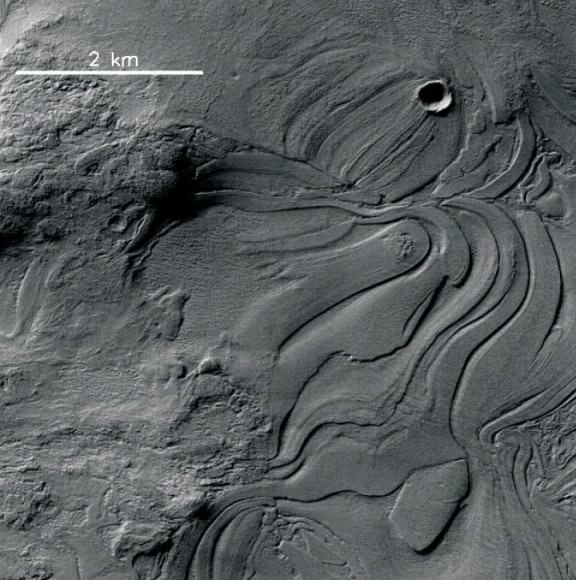
One of the “weirdest and least understood” areas of Mars, the enormous Hellas Impact Basin contains strange flowing landforms that bespeak of some specialized and large-scale geologic process having taken place. The HiRISE camera aboard NASA’s Mars Reconnaissance Orbiter recently captured the image above, showing what’s being called “lava lamp terrain” — stretched and contorted surface that looks like overworked modeling clay or pulled taffy… or, with a bit of imagination, the melted, mesmerizing contents of a party light from another era.

At 1,400 miles (2,300 km) across, Mars’ Hellas Basin is one of the largest impact craters in the entire Solar System. Its vast interior sinks to a depth of about 23,000 feet (7152 meters) below Mars’ average surface elevation (Martian “sea level”, if you will) and thus its floor is often shrouded by haze and dust, making visual imaging difficult.

The “lava lamp” terrain is just one of many different types of landforms that are found in the basin, although many of these banded features are found in the northwest area — which is also the deepest part of the basin. If there had been water in the region at some point in the planet’s history, it would have concentrated there.

Although the texture at first appears as if it could be volcanic in origin, it’s thought that flowing water or ice may actually be the source.

Researchers are currently working to determine how the Hellas Basin became so smoothly sculpted. Nicolas Thomas, Professor of Experimental Physics at the University of Bern, Switzerland, told Universe Today:

“There are a lot of very interesting images from this area and we are trying to get more data (including stereo) to understand better what’s going on and to try to establish what process is responsible for the numerous bizarre features we see. We are hoping to make some more progress in the next few months.”

Example of banded terrain. Compare the relatively fresh appearance of the bands with the older terrain seen to the left of this sub-image. (NASA/JPL/University of Arizona/N. Thomas et al.)

This hypothesis is also in line with the possibility of Hellas Basin having once been a giant lake.

“Together with the observations of isolated areas and the lack of obvious caldera(s), it is difficult to envisage a volcanic origin for these features and we currently tend towards a mechanism involving ice,” Thomas stated in an abstract of a presentation given at the Europlanet Conference in 2010.

Read the full abstract here, and see this and more high-resolution images from Mars on the HiRISE website.

Was This Ancient Monolith a Stone Age Astronomy Tool?

The Gardoms Edge Monolith (Credit: Daniel Brown / Nottingham Trent University)

[/caption]

Is this 2-meter-high slab of lichen-covered rock in a UK park an astronomical marker used by Neolithic people? Researchers from Nottingham Trent University are suggesting that may in fact be the case, based on the stone’s alignment, angle and proximity to other significant Stone and Bronze Age sites nearby.

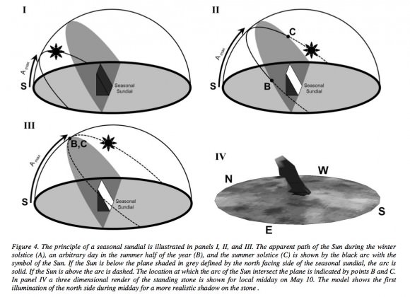
The angular rock, known as the Gardom’s Edge Monolith, resides within the Peak District National Park in the central northern area of England. The research team has found that it’s aligned in such a way that its north side slopes at an angle equal to the maximum altitude of the Sun during the summer solstice.

Not thought to be so much a sundial as a seasonal dial, the shadows cast by the monolith seem to mark specific times of year… possibly denoting the “life cycle” of the Sun in the heavens.

Standing stones being rare in the region, It’s estimated that the monolith was set in place anywhere from 2,500 — 1,500 B.C. Evidence of packed stones and earth at the base also suggests human placement.

The team believes that the stone may have been a gathering point for ancient communities in the area.

“The stone would have been an ideal marker for a social arena for seasonal gatherings,” said Dr. Daniel Brown, lead author of the team’s paper. “It’s not a sundial in the sense that people would have used it to determine an exact time. We think that it was set in position to give a symbolic meaning to its location, a bit like the way that some religious buildings are aligned in a specific direction for symbolic reasons.”

Computer modeling of the stone and the Sun’s position throughout the year show that the stone’s slanted side would be in shadow during the winter, while during the summer it would be lit in the morning and afternoon. During midsummer, however, it would be illuminated all day.

Illustration of solar positions and a seasonal sundial (Daniel Brown et al.)

More modeling and photographic work will be needed to confirm this hypothesis. If supported, it could lead to more archaeological study of the area.

Read the team’s full paper here, and read more on Sci-News.com.