A Crescent Moon in the Martian Sky

Raw image of Phobos above Mars, taken by Curiosity's Mastcam in September 2012. Credit: NASA/JPL-Caltech

Mars’ moon Phobos is captured in a daytime image by Curiosity (NASA/JPL-Caltech/MSSS)

A raw image taken on September 21 by Curiosity’s right Mastcam shows a daytime view of the Martian sky with a crescent-lit Phobos in the frame… barely visible, yes, but most certainly there. Very cool!

The image above is a crop of the original, contrast-enhanced and sharpened to bring out as much detail as possible.

The 13-km-wide Phobos has been spotted several times before by Mars rovers, most recently during a solar transit on September 13 (sol 37) but I’m not sure if it’s ever been clearly captured on camera during the day before (i.e., not passing in front of the Sun.) If not, this will be a first!

See the latest news from the Curiosity mission here.

Added 9/28: According to Universe Today publisher Fraser Cain, this is “the most dramatic space picture of the year”… whether you agree or not, hear what he had to say on this and other recent news during the September 27 episode of the Weekly Space Hangout.

How Many Asteroids Are Out There?

Answer: a LOT. And there’s new ones being discovered all the time, as this fascinating animation by Scott Manley shows.


Created using data from the IAU’s Minor Planet Center and Lowell Observatory, Scott’s animation shows the progression of new asteroid discoveries since 1980. The years are noted in the lower left corner.

As the inner planets circle the Sun, asteroids light up as they’re identified like clusters of fireflies on a late summer evening. The clusters are mainly positioned along the outer edge of Earth’s orbit, as this is the field of view of most of our telescopes.

Once NASA’s WISE spacecraft begins its search around 2010 the field of view expands dramatically, as well as does the rate of new discoveries. This is because WISE’s infrared capabilities allowed it to spot asteroids that are composed of very dark material and thus reflect little sunlight, yet still emit a telltale heat signature.

While Scott’s animation gives an impressive — and somewhat disquieting — illustration of how many asteroids there are knocking about the inner Solar System, he does remind us that the scale here has been very much compacted; a single pixel at the highest resolution corresponds to over 500,000 square kilometers! So yes, over half a million asteroids is a lot, but there’s also a lot of space out there (and this is just a 2D top-down view too… it doesn’t portray any vertical depth.)

While most asteroids are aligned with the horizontal plane of the Solar System, there are a good amount whose orbits take them at higher inclinations. And on a few occasions they even cross Earth’s orbit.

(Actually, on more than just a few.)

Read: 4700 Asteroids Want to Kill You

An edge-on view of the Solar System shows the positions of asteroids identified by the NEOWISE survey. About 4700 potentially-hazardous asteroids (PHAs) have been estimated larger than 100 meters in size. (NASA/JPL-Caltech)

As far as how many asteroids there are… well, if you only consider those larger than 100 meters orbiting within the inner Solar System, there’s over 150 million. Count smaller ones and you get even more.

I don’t know about you but even with the distances involved it’s starting to feel a little… crowded.

You can see more of Scott Manley’s videos on YouTube here (including some interesting concepts on FTL travel) and learn more about asteroids and various missions to study them here.

Inset image: the 56-km (35-mile) wide asteroid Ida and its satellite, seen by the Galileo spacecraft in 1993. (NASA)

Astronomers Discover Milky Way’s Hot Halo

Artist's impression of the huge halo of hot gas surrounding the Milky Way Galaxy. Credit: NASA

Artist’s illustration of a hot gas halo enveloping the Milky Way and Magellanic Clouds (NASA/CXC/M.Weiss; NASA/CXC/Ohio State/A.Gupta et al.)

Our galaxy — and the nearby Large and Small Magellanic Clouds as well — appears to be surrounded by an enormous halo of hot gas, several hundred times hotter than the surface of the Sun and with an equivalent mass of up to 60 billion Suns, suggesting that other galaxies may be similarly encompassed and providing a clue to the mystery of the galaxy’s missing baryons.

The findings were reported today by a research team using data from NASA’s Chandra X-ray Observatory.

In the artist’s rendering above our Milky Way galaxy is seen at the center of a cloud of hot gas. This cloud has been detected in measurements made with Chandra as well as with the European Space Agency’s XMM-Newton space observatory and Japan’s Suzaku satellite. The illustration shows it to extend outward over 300,000 light-years — and it may actually be even bigger than that.

While observing bright x-ray sources hundreds of millions of light-years distant, the researchers found that oxygen ions in the immediate vicinity of our galaxy were “selectively absorbing” some of the x-rays. They were then able to measure the temperature of the halo of gas responsible for the absorption.

The scientists determined the temperature of the halo is between 1 million and 2.5 million kelvins — a few hundred times hotter than the surface of the Sun.

But even with an estimated mass anywhere between 10 billion and 60 billion Suns, the density of the halo at that scale is still so low that any similar structure around other galaxies would escape detection. Still, the presence of such a large halo of hot gas, if confirmed, could reveal where the missing baryonic matter in our galaxy has been hiding — a mystery that’s been plaguing astronomers for over a decade.

Unrelated to dark matter or dark energy, the missing baryons issue was discovered when astronomers estimated the number of atoms and ions that would have been present in the Universe 10 billion years ago. But current measurements yield only about half as many as were present 10 billion years ago, meaning somehow nearly half the baryonic matter in the Universe has since disappeared.

Recent studies have proposed that the missing matter is tied up in the comic web — vast clouds and strands of gas and dust that surround and connect galaxies and galactic clusters. The findings announced today from Chandra support this, and suggest that the missing ions could be gathered around other galaxies in similarly hot halos.

Even though previous studies have indicated halos of warm gas existing around our galaxy as well as others, this new research shows a much hotter, much more massive halo than ever detected.

“Our work shows that, for reasonable values of parameters and with reasonable assumptions, the Chandra observations imply a huge reservoir of hot gas around the Milky Way,” said study co-author Smita Mathur of Ohio State University in Columbus. “It may extend for a few hundred thousand light-years around the Milky Way or it may extend farther into the surrounding local group of galaxies. Either way, its mass appears to be very large.”

Read the full news release from NASA here, and learn more about the Chandra mission here. (The team’s paper can be found on arXiv.org.)

Inset image: NASA’s Chandra spacecraft (NASA/CXC/NGST)

NOTE: the initial posting of this story mentioned that this halo could be dark matter. That was incorrect and not implied by the actual research, as dark matter is non-baryonic matter while the hot gas in the halo is baryonic — i.e., “normal” —  matter. Edited. – JM

Fly Over California Alongside a Space Shuttle!

A view of Endeavour and SCA over California from one of NASA’s F/A-18 chase planes (NASA/DFRC)

We’ve shared several videos from Endeavour’s trip to Los Angeles last week, taken by excited spectators along various portions of the flight path, but what was it like for the crews of the two NASA F/A-18 chase planes that accompanied the orbiter and SCA every step of the way?

Watch the video below, and put yourself in the pilot’s seat…

Shared by NASA’s Dryden Flight Research Center, the video shows footage taken from the viewpoint of one of the chase planes as Endeavour was ferried aboard a Shuttle Carrier Aircraft from Edwards Air Force Base to Los Angeles International Airport.

Along the way SCA pilots Jeff Moultrie and Bill Rieke, both from NASA’s Johnson Space Center, guided the 747 over such landmarks as the State Capitol in Sacramento, the Golden Gate Bridge at San Francisco, and NASA’s Ames Research Center.

Once over the Los Angeles area Endeavour passed over well-known landmarks like Griffith Observatory, the Hollywood sign, Dodger Stadium, NASA’s Jet Propulsion Laboratory, Malibu Beach and the Santa Monica Pier, and Disneyland.

After several low flybys of the runway — some under 300 feet! — the SCA touched down at LAX on Runway 25L at 12:51 p.m. PDT.

NASA’s four F/A-18 Hornet aircraft, operated by Dryden Flight Research Center, are commonly called chase planes and fill the role of escort aircraft during research missions. They also are used as camera platforms for research missions that must be photographed or videotaped. Two of these chase planes accompanied Endeavour on its flight for such documentation as well as for security.

See more images of the F/A-18s here, and for more photos of Endeavour’s trip to California check out the NASA photographer photo set on Flickr.

Video: Dryden TV

Curiosity Shows Off Its Credentials

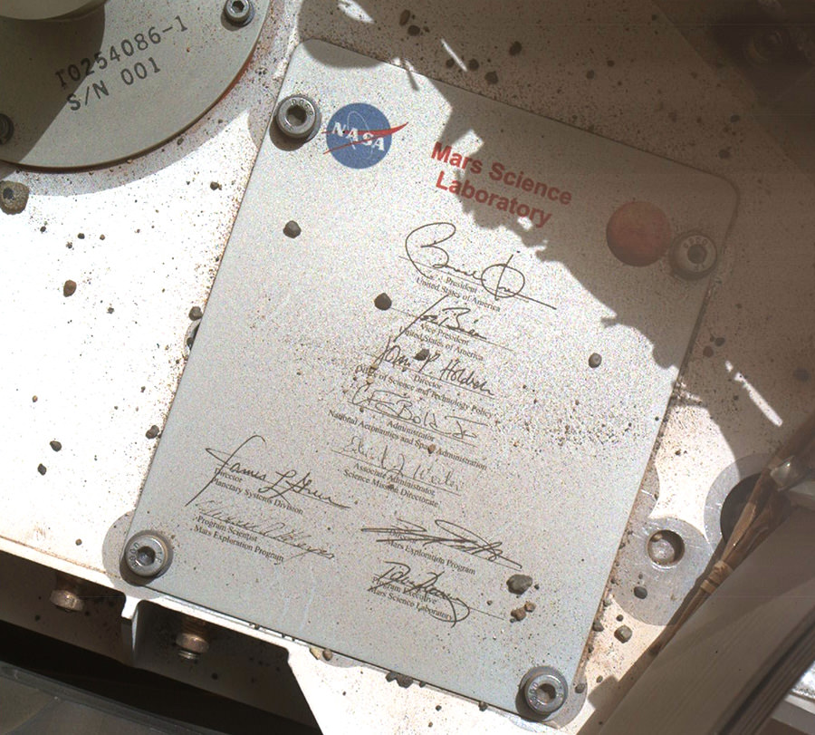
Plaque on the exterior of Mars Science Laboratory, aka “Curiosity” (NASA/JPL-Caltech/MSSS)

Curiosity drops a few rather big names in recent images taken with its MAHLI (Mars Hand Lens Imager) camera: here we see a plaque affixed to its surface bearing the names and signatures of U.S. President Barack Obama, Vice President Joe Biden, Office of Science and Technology Director John Holdren, NASA Administrator Charles Bolden and other key figures responsible for making the Mars Exploration Program possible.

You never know… even on another planet it can’t hurt to have friends in high places!

The image was captured by MAHLI on September 19, the 44th sol of the MSL mission. (See the original raw downlink here.)

The rectangular plaque is made of anodized aluminum, measuring 3.94 inches (100 mm) high by 3.23 inches (82 mm) wide. It’s attached to the front left side of Curiosity’s deck with four bolts. (Explore Curiosity in 3D here.)

Dust, pebbles and variously-sized bits of Mars can be seen scattered around the plaque and deck, leftover detritus from the rover’s landing.

The complete list of signatures is:

Barack Obama, President, United States of America

Joe Biden, Vice President

John P. Holdren, Director, Office of Science and Technology Policy

Charles F. Bolden, Jr., Administrator, National Aeronautics and Space Administration

Edward J. Weiler, Associate Administrator, Science Mission Directorate (2008–2011)

James Green, Director, Planetary Sciences Division

Doug McCuistion, Director, Mars Exploration Program

Michael Meyer, Program Scientist, Mars Exploration Program

David Lavery, Program Executive, Mars Science Laboratory

In another image taken on the same sol, Curiosity shows some national pride with a circular medallion decorated with the stars and stripes of the American flag. The 68-mm-wide circular aluminum plate is affixed to one of the rover’s rocker arms. It’s just one of its four “mobility logos” — the others having the NASA logo, the JPL logo and the Curiosity mission logo.

Curiosity’s “stars and stripes” American flag mobility logo (NASA/JPL-Caltech/MSSS)

The main purpose of Curiosity’s MAHLI camera is to acquire close-up, high-resolution views of rocks and soil at the rover’s Gale Crater field site. Developed for NASA by Malin Space Science Systems in San Diego, CA, the camera is capable of focusing on any target at distances of about 0.8 inch (2.1 centimeters) to infinity, providing versatility for other uses, such as views of the rover itself from different angles.

Get more technical information about the MAHLI camera here.

Saturn Shows Off Its Shadow

Take a look up at the enormous shadow cast by Saturn onto its own rings in this raw image, acquired by NASA’s Cassini spacecraft on September 18, 2012.

Cassini captured this image from below Saturn’s ring plane at a distance of 1,393,386 miles (2,242,437 kilometers). It shows not only the gas giant’s shadow but also the wispy nature of the rings, which, although complex, extensive and highly reflective (the light seen on Saturn above is reflected light from the rings!) they are still very thin — less than a mile (about 1 km) on average and in some places as little as thirty feet (10 meters) thick.

Seen in the right light, some of the thin innermost rings can seem to nearly disappear entirely — especially when backlit by Saturn itself.

Views like the one above are once again possible because of Cassini’s new orbit, which takes it high above and below the ring plane, providing a new perspective for studying Saturn and its moons. Ultimately by next April the spacecraft will be orbiting Saturn at an inclination of about 62 degrees — that’d be like an orbit around Earth that goes from Alaska to the northernmost tip of Antarctica. (Find out how Cassini alters its orbit here.)

With this viewpoint Cassini will get some great views of Saturn’s north and south poles, which are gradually moving into their summer and winter seasons, respectively, during the ringed planet’s 29.5-Earth-year orbital period.

After more than 8 years in orbit Cassini is still fascinating us with enthralling images of Saturn on a regular basis. Read more about the Cassini mission here.

Cassini spots shepherd moons Pan (within the Encke Gap) and Prometheus (along the inner edge of the F ring) in an image acquired on Sept. 18, 2012

Images: NASA/JPL/Space Science Institute.

Fires in the Sky: Aurorae and Meteor Photo by Ole Salomonsen

A bright fireball slashes through curtains of aurorae shimmering above the mountains of northern Norway, captured on camera by Ole C. Salomonsen in the early hours of September 20.

Salomonsen, a master at photographing the Northern Lights, says this was the biggest fireball he’s ever caught on camera.

“The fireball lasted for about 6-7 seconds until it vanished behind the mountain,” Ole recalls. “By the way, this mountain is over 1350 meters (4440 feet) high, and I am standing only 600 meters from the foot of it, so do not be fooled by the 14mm wide angle lens! There was some very distinguished blue colors surrounding the fireballs edges. Never ever seen anything big like this!”

The mountain at right is called “Otertinden”, and is about a 90 minute drive north of Tromsø, Norway — a hot spot for stunning auroral displays.

And if you’re wondering if the aurorae and the meteor are really in the same region of the atmosphere, well, they likely are. Incoming meteoroids begin to glow at around 70 to 100 km up, which is also about the same altitude that aurorae are visible.

Although Ole stated that this wasn’t the best aurora photo from the shoot, the fireball and its reflection in the still river made him feel this one “deserved to go first.”

The photo was taken with a Canon EOS 1D-X and a Nikon 14-24mm lens.

See more of Ole’s work on his website, www.arcticlightphoto.no, and you can like his page on Facebook here. (Also he’s got a couple of great time-lapse videos too!)

Image © Ole C. Salomonsen. All rights reserved. Used with permission.

35 Years Ago: Our First Family Portrait of the Earth and Moon

A crescent Earth and Moon as seen by Voyager 1 on September 18, 1977 (NASA)

35 years ago today, September 18, 1977, NASA’s Voyager 1 spacecraft turned its camera homeward just about two weeks after its launch, capturing the image above from a distance of 7.25 million miles (11.66 million km). It was the first time an image of its kind had ever been taken, showing the entire Earth and Moon together in a single frame, crescent-lit partners in space.

The view of Earth shows eastern Asia, the western Pacific Ocean and part of the Arctic. Voyager 1 was actually positioned directly above Mt. Everest when the images were taken (the final color image was made from three separate images taken through color filters.)

The Moon was brightened in the original NASA images by a factor of three, simply because Earth is so much brighter that it would have been overexposed in the images were they set to expose for the Moon. (Also I extended the sides of the image a bit above to fit better within a square format.)

Read the latest on Voyager 1: Winds of Change at the Edge of the Solar System

Previous images may have shown the Earth and Moon together, but they were taken from orbit around one or the other and as a result didn’t have both worlds fully — and in color! — within a single frame like this one does. In fact, it was only 11 years earlier that the very first image of Earth from the Moon was taken, acquired by NASA’s Lunar Orbiter I spacecraft on August 23, 1966.

It’s amazing to think what was happening in the world when Voyager took that image:
• World population was 4.23 billion (currently estimated to be 7.04 billion)
• The Space Shuttle Enterprise made its first test flight from a 747
• Star Wars, Close Encounters of the Third Kind and Saturday Night Fever were out in U.S. theaters
• Charlie Chaplin and Elvis Presley died
• U.S. federal debt was “only” $706 billion (now over $16 trillion!)
• And, of course, both Voyagers launched on their Grand Tour of the Solar System, ultimately becoming the most distant manmade objects in existence
(See more world stats and events here.)

Image: NASA/JPL

“Once a photograph of the Earth, taken from outside, is available – once the sheer isolation of the Earth becomes known – a new idea as powerful as any in history will be let loose.”
– Sir Fred Hoyle

NASA Probes Play the Music of Earth’s Magnetosphere

Launched on August 30, 2012, NASA’s twin Radiation Belt Storm Probe (RBSP) satellites have captured recordings of audible-range radio waves emitted by Earth’s magnetosphere. The stream of chirps and whistles heard in the video above consist of 5 separate occurrences captured on September 5 by RBSP’s Electric and Magnetic Field Instrument Suite and Integrated Science (EMFISIS) instrument.

The events are presented as a single continuous recording, assembled by the (EMFISIS) team at the University of Iowa and NASA’s Goddard Space Flight Center.

Called a “chorus”, this phenomenon has been known for quite some time.

“People have known about chorus for decades,” says EMFISIS principal investigator Craig Kletzing of the University of Iowa. “Radio receivers are used to pick it up, and it sounds a lot like birds chirping. It was often more easily picked up in the mornings, which along with the chirping sound is why it’s sometimes referred to as ‘dawn chorus.’”

The radio waves, which are at frequencies that are audible to the human ear, are emitted by energetic particles within Earth’s magnetosphere, which in turn affects (and is affected by) the radiation belts.

The RBSP mission placed a pair of identical satellites into eccentric orbits that will take them from as low as 375 miles (603 km) to as far out as 20,000 miles (32,186 km). During their orbits the satellites will pass through both the stable inner and more variable outer Van Allen belts, one trailing the other. Along the way they’ll investigate the many particles that make up the belts and identify what sort of activity occurs in isolated locations — as well as across larger areas.

Read: New Satellites Will Tighten Knowledge of Earth’s Radiation Belts

Audio Credit: University of Iowa. Visualisation Credit: NASA/Goddard Space Flight Center. (H/T to Peter Sinclair at climatecrocks.com.)

Manhattan-Sized Ice Island Heads Out to Sea

An “ice island” that calved from the Petermann Glacier in July is seen by NASA satellite (MODIS/Terra)

Remember that enormous slab of ice that broke off Greenland’s Petermann Glacier back in July? It’s now on its way out to sea, a little bit smaller than it was a couple of months ago — but not much. At around 10 miles long and 4.6 miles across (16.25 x 7.5 km) this ice island is actually a bit shorter than Manhattan, but is fully twice as wide.

The image above was acquired on September 14 by the Moderate Resolution Imaging Spectroradiometer (MODIS) aboard NASA’s Terra satellite.

Although the calving of this particular ice island isn’t thought to be a direct result of increasing global temperatures, climate change is thought to be a major factor in this year’s drop in Arctic sea ice extent, which is now below 4.00 million square kilometers (1.54 million square miles). Compared to September conditions in the 1980s and 1990s, this represents a 45% reduction in the area of the Arctic covered by sea ice.

Arctic sea ice extent data for June-July 2012 (NSIDC)

This year sea ice in the Arctic Ocean dropped below the previous all-time record, set in 2007. 2012 also marks the first time that there has been less than 4 million square kilometers (1.54 million square miles) of sea ice since satellite observations began in 1979.

The animation below, released today by the NOAA, shows the 2012 time-series of ice extent using data from the DMSP SSMI/S satellite sensor:

Read more here.