As Earth's climate warms, glaciers are retreating. This is evident all around the world. Glacial retreat isn't always a peaceful process and can significantly effect the landscape. Our fleet of Earth-observing satellites bears witness to these changes.
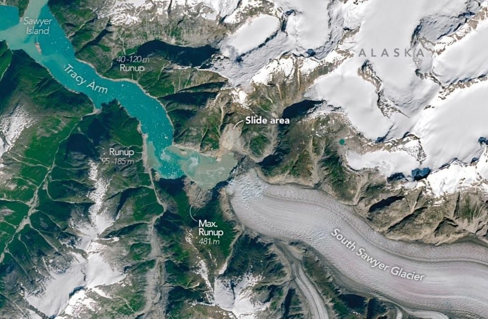
In 2025, the retreating South Sawyer Glacier in Alaska's Tracy Arm, a fjord near Juneau, triggered a large landslide. As the debris from the landslide smashed into the water, it created a megatsunami that swept down the fjord into the ocean. On its way down, it reached a maximum height of 481 m (1,578 ft), the second highest tsunami known to humans.
A team of scientists led by Dan Shugar, a geomorphologist at the University of Calgary in Canada, reconstructed the tsunami and published their results in Science. It's titled "A 481-meter-high landslide-tsunami in a cruise ship–frequented Alaska fjord." The researchers used satellite images, aerial images, and ground-based data to understand how the event unfolded.
“The bright landslide scar on the north side of the fjord is striking, as is the ‘bathtub’ ring around the fjord showing the areas where the forest was leveled by the tsunami,” lead author Shugar said in a press release.
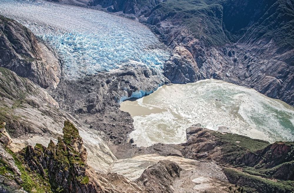 *This aerial photo from August 2025 shows the landslide scar at the foot of the glacier. Trees and vegetation were stripped away and sent down the fjord, and the landslide debris triggered a tsunami. Image Credit: U.S. Geological Survey/John Lyons*
The glaciers themselves have shaped the fjords. Glaciers are like massive, slow-moving rivers of ice, and just as rivers have carved vast features like the Grand Canyon, glaciers have carved out the Alaskan fjords. Fjords like Tracy Arm prevent tsunamis from spreading out and dissipating their energy. Instead, the water barrels down the fjord, running up the sides in some place and stripping away trees and vegetation. Sawyer Island, about 9 km down the fjord, was almost stripped clean, with only a few trees left standing.
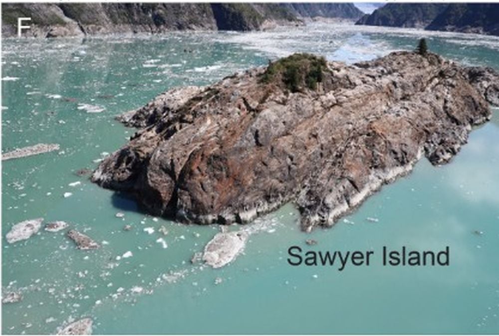 The landslide tsunami stripped Sawyer Island almost completely bare. Only a few trees remain. Image Credit: Shugar et al. 2026. Science.
"Landslide-generated tsunamis (hereafter referred to as landslide-tsunamis) can have substantially higher runups (the maximum height water reaches on a slope) than earthquake tsunamis, owing to larger, localized variations in water depth and direct water-column displacement by slope failure—most pronounced in confined water bodies like fjords," the researchers explain in their paper.
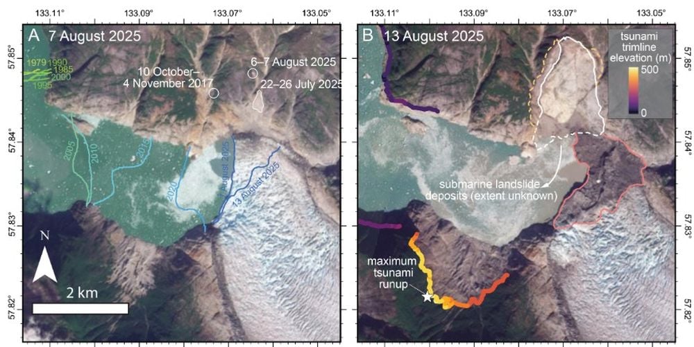 These before and after images provide more detail and show the glacier terminus, landslide, and maximum run-up. Image Credit: Shugar et al. 2026. Science.
In their paper, the authors also stressed the growing risk from tsunamis like this one.
"With fjord regions increasingly visited by cruise ships, and climate change making similar events more likely, this unanticipated, near-miss event highlights the growing risk from landslides and tsunamis in coastal environments," the authors write.
The tsunami's effect on the fjord wasn't confined to the day it occured. For more than 24 hours after the initial event, water continued to "slosh" around in the fjord in what's called a seiche. Together with the landslide, the seiche produced seismic signals that were equivalent to an earthquake at 5.4 on the Richter scale.
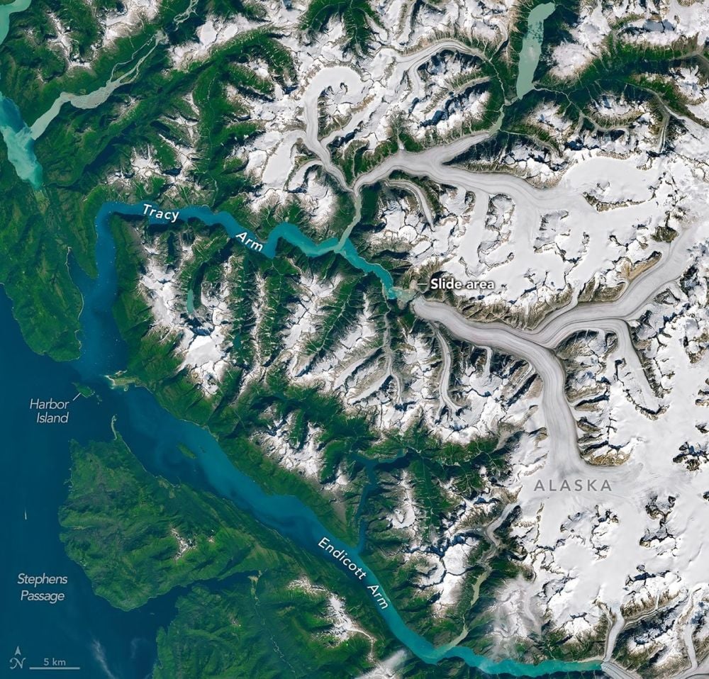 *This larger image from the OLI (Operational Land Imager) on Landsat 9 shows Tracy Arm in context. It and other fjords flow into a larger passage called Stephens Passage, which is an important waterway in this part of Alaska. Image Credit: NASA Earth Observatory/Michala Garrison*
There were no injuries from this tsunami, but there nearly were. Some kayakers camping on an island at the fjord's mouth had their kayaks and their gear swept away. A small vessel in Endicott Arm, a neighbour to Tracy Arm, saw strong currents and changes in the water level.
As Alaskan cruises grow in popularity, the risk from landslide tsunamis will only increase. Ironically, it's the retreating glaciers themselves which attract more traffic. "Fjords with retreating tidewater glaciers are increasingly popular destinations for cruise ships and smaller vessels throughout the Arctic and Subarctic, particularly in southeast Alaska," the researchers write. "In the past few years, cruise ship passenger numbers in Alaska have increased from an annual average of ~1,000,000 in 2016 to ~1,600,000 in 2025."
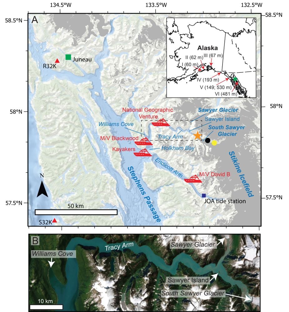 These two panels from the published research provide more detail. Red ships show eyewitness locations, red triangles show the nearest seismometers, and the green square shows Juneau, where a tide guage is also located. The inset map shows Juneau with a green square, and the locations of landslide-tsunamis in the past century with over 50 m runup. Image Credit: Shugar et al. 2026. Science.
In their conclusion, the authors point out that "warming climates increase the frequency of large landslides in glaciated fjords..." They also say that seismic waves from the landslide-induced seiches (LSI) from these events could shed some light on how to acquire early warnings of them in the future.
"This offers a new pathway for near-real-time detection of hazardous fjord processes in regions with sparse tide-gage data or satellite coverage, motivating automated seismic searches for narrowband signals as part of early-warning frameworks," they write.