Valles Marineris: The Grandest Canyon of All
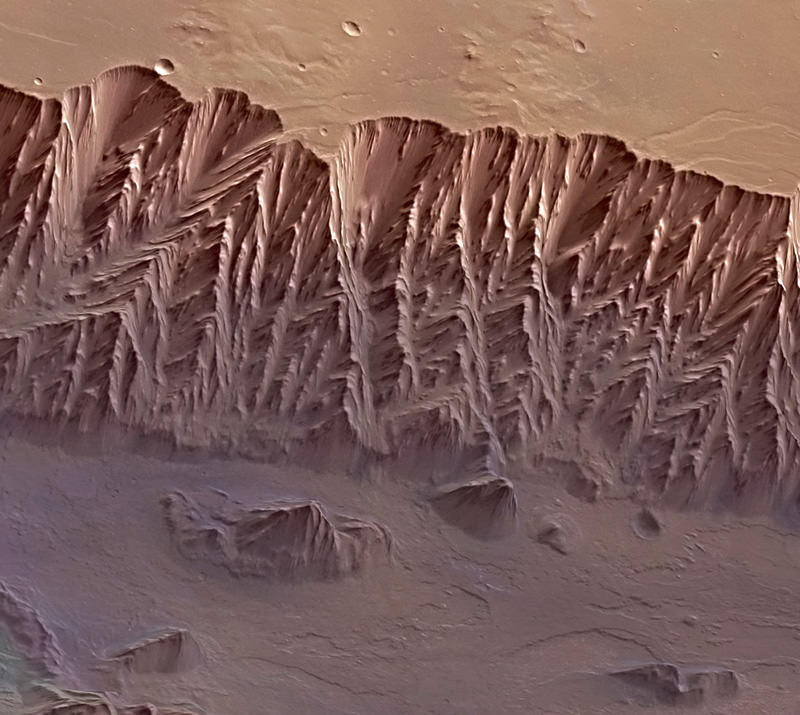
A digital terrain model of a portion of Mars’ Valles Marineris, the largest canyon in the Solar System. Credit: ESA/DLR/FU Berlin (G. Neukum)
Anyone who’s visited the Grand Canyon in Arizona can attest to its beauty, magnificence and sheer sense of awe that comes upon approaching its rim, whether for the first time or hundred-and-first. “Grand” almost seems too inferior a title for such an enormous geological feature — yet there’s a canyon much, much bigger stretching across the surface of Mars, one that could easily swallow all of our Grand Canyon within one of its side gullies.
The image above, released online for the first time today by ESA, is a digital terrain model of a portion of Mars’ Valles Marineris: our Solar System’s grandest canyon.
Valles Marineris is thought to be the result of the formation of the nearby Tharsis volcanic region, home to Olympus Mons, the Solar System’s largest volcano. As the region swelled with magma billions of years ago the planet’s crust stretched and split, collapsing into a vast, deep canyon.
The 45-degree view above was was made from data acquired during 20 individual orbits of ESA’s Mars Express. It is presented in near-true color with four times vertical exaggeration (to increase relief contrast.) Download a high-res JPEG version here.
The largest portion of the canyon seen crossing left to right is known as Melas Chasma. Candor Chasma is the connecting trough to the north, and Hebes Chasma is in the far top left.
Below is a video released by JPL in 2006 showing a virtual fly-through of Valles Marineris, shown as if you were on a Grand Canyon-style helicopter sightseeing tour (that is, if helicopters could even work in the thin Martian air!)
Hopefully someday we’ll be seeing actual videos taken above Valles Marineris and photos captured from its rim… perhaps even by human explorers! (Please exit through the gift shop.)
Image source: ESA. Video by Eric M. De Jong and Phil Christiansen et. al, Arizona State University.
Recent Posts
China Creates a High-Resolution Atlas of the Moon
Multiple space agencies are looking to send crewed missions to the Moon's southern polar region…
Dinkinesh's Moonlet is Only 2-3 Million Years Old
Last November, NASA's Lucy mission conducted a flyby of the asteroid Dinkinish, one of the…

The Universe Could Be Filled With Ultralight Black Holes That Can't Die
Steven Hawking famously calculated that black holes should evaporate, converting into particles and energy over…
Starlink on Mars? NASA Is Paying SpaceX to Look Into the Idea
NASA has given the go-ahead for SpaceX to work out a plan to adapt its…
Did You Hear Webb Found Life on an Exoplanet? Not so Fast…
The JWST is astronomers' best tool for probing exoplanet atmospheres. Its capable instruments can dissect…
Vera Rubin’s Primary Mirror Gets its First Reflective Coating
First light for the Vera Rubin Observatory (VRO) is quickly approaching and the telescope is…