
Image credit: NASA/JPL
NASA has released 10,232 new images of the Red Planet taken by the Mars Global Surveyor spacecraft, including wind whipped polar dunes, steep-walled valleys, and boulder-strewn terrain. The images were taken over the course of several months, from August 2002 to February 2003, and they include views all over the planet. This brings the total number of images taken by Surveyor in six years of observation to more than 134,000.
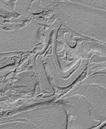
Thousands of newly released portraits of martian landscapes from NASA’s Mars Global Surveyor spacecraft testify to the diversity of ways geological processes have sculpted the surface of our neighboring planet.
Swirling textures that some scientists call “taffy-pull terrain? fill one new image from the plains of southern Mars, for example. Other images reveal details of features such as wind-whipped polar dunes and steep-sided valleys carved by flowing water or lava.
The 10,232 newly released pictures from the Mars Orbiter Camera on Mars Global Surveyor bring the total number of images in the camera’s online gallery to more than 134,000. The new batch is at: http://www.msss.com/mars_images/moc/2003/09/30/.
“Mars just keeps astounding us with its complexity,” said Dr. Ken Edgett, staff scientist for Malin Space Science Systems, San Diego, Calif, which built and operates the Mars Orbiter Camera.
The new group of images was taken between August 2002 and February 2003, then validated and archived by the camera team. It includes many views of north polar terrain, extremely clear-atmosphere views of a deep southern basin named Hellas Planitia, and a variety of martian landforms between the north pole and the southern middle latitudes. The pictures show martian surface details down to the size of a large sport utility vehicle.
Since Mars Global Surveyor began orbiting Mars six years ago, the mission has provided a wealth of information about the planet’s atmosphere and interior, as well at its surface.
Evaluation of landing sites for NASA’s Spirit and Opportunity, two Mars Exploration Rover spacecraft due to land on Mars in January 2004, relied heavily on mineral mapping, detailed imagery and topographic measurements by Global Surveyor.
Additional information about Mars Global Surveyor is available online at: http://mars.jpl.nasa.gov/mgs/.
In addition to semi-annual releases of large collections of archived pictures, the Mars Orbiter Camera team posts a new image daily and recently began soliciting public suggestions for camera targets on Mars. The full gallery is available at: http://www.msss.com/moc_gallery/.
Original Source: NASA News Release