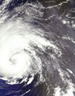
Image credit: ESA
The European Space Agency is helping to track the movement of Hurricane Isabel using its ERS-2 spacecraft, and released this photo of the storm Thursday morning as it menaced the East Coast of the US. ERS-2 has also been gathering other information about the storm, including sea surface temperatures, wind and rainfall levels. Isabel is a Category 2 hurricane, and expected to make landfall in the early afternoon on Thursday in North Carolina.
As Hurricane Isabel converges on the US East Coast, a veteran ESA spacecraft has provided meteorologists with crucial insights into the underlying pressure system powering the storm.
An entire flotilla of satellites is being kept busy tracking Hurricane Isabel in visible and infrared light, as well as gathering additional measurements of local sea surface temperature, wind and rainfall levels. ESA spacecraft ERS-2 has made the picture more detailed still by discerning the wind speed and direction around the hurricane's cloud and rain-wracked heart.
ERS-2 instruments include a C-band scatterometer, which works by sending a high-frequency radar pulse down to the ocean, then analysing the pattern of backscatter reflected back again. Scatterometers are particularly useful in measuring wind speed and direction at the sea surface, by detecting signature scatter from ripples on the water caused by wind.
ERS-2's scatterometer is less sensitive than comparable space-based instrumentsto rain or bad weather, and can gather data both day and night. This makes it invaluable as an early detector of Atlantic storms ? especially in the current hurricane season.
The Isabel data was obtained mid-afternoon Wednesday at one of ESA?s ground stations in Gatineau Canada, then rapidly delivered to meteorology offices worldwide. At the Reading-based European Centre for Medium-Range Weather Forecasts (ECMWF), it was analysed against the surface wind pattern predicted by their existing software simulation of Isabel, run on powerful supercomputers.
"The ERS wind data is very valuable to us," said Hans Hersbach of ECMWF. "It shows differences with our analysis, for instance a lack of inward wind flow into the centre. By assimilating the data into our analysis we improve our forecasting skills.
"The ESA scatterometer data was routinely assimilated into our analysis after 1997, until it become no longer available early this century. Now the service has been resumed we are making use of it once more."
ESA's ERS-2 has been in orbit since 1995, but the service from the scatterometer was interrupted in 2001. A degradation in attitude control prevented access to the data. Meteorologists lost a valuable window on the weather ? until this summer, when after two-and-a-half-years of effort, new processing software developed by the Belgian Royal Military Academy (RMA) compensated for the degradation and regained access to scatterometer measurements.
The software algorithm was installed in ground stations at Kiruna in Sweden, Maspalomas in the Canary Islands Gatineau in Canada as well as Frascati in Italy, with an additional installation planned for West Freugh in Scotland. The new service began at the end of August, just in time for Hurricane Isabel's dramatic arrival.
To maintain future continuity of scatterometer coverage, a new more advanced scatterometer instrument called ASCAT is part of the payload for ESA?s MetOp mission, currently due to launch in 2005.
Inside a hurricane
Hurricanes are large powerful storms that rotate around a central area of extreme low pressure. They arise in warm tropical waters that transfer their heat to the air. The warmed air rises rapidly, in the process creating low pressure at the water surface. Winds begin rushing inwards and upwards around this low-pressure zone.
Currently classed at Category Two on the five-point Saffir-Simpson Hurricane scale, Isabel originated in the eastern Atlantic last week. It is currently moving northwest at only about 24 kilometres an hour but winds within it are rotating at about 160 km per hour. Meteorologists forecast the hurricane will make landfall in North Carolina on Thursday.
ESA News Release