Image credit: NASA/JPL
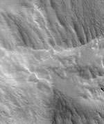
For the past few weeks, NASA has been letting the public select targets for the Mars Global Surveyor spacecraft, and the first image was released today. The location was the summit crater of a giant volcano called Pavonis Mons - the walls and floor of the crater are covered with thick dust. It was suggested by U.S. Marine Lance Corporal Robert F. Sanders, of Jacksonville, N.C. from the hundreds of selections submitted so far. Mars Global Surveyor has taken 120,000 images of the planet's surface in high detail, but this is only 3% of the entire planet.
If you were given a chance to aim the camera on NASA's Mars Global Surveyor Mars Orbiter and take a picture of something on the red planet, what would you shoot?
Now we know, after NASA released today the first picture selected from hundreds of public suggestions. The photo reveals a thick layer of dust blanketing the floor and wall of the summit crater atop a tall volcano called Pavonis Mons.
"It's such a thrill to see it," said U.S. Marine Lance Corporal Robert F. Sanders, of Jacksonville, N.C., who suggested the crater close up as a photo target for the Mars Global Surveyor camera. "I spent hours coming up with suggestions, but I didn't know whether any of them would be accepted."
The resulting picture shows details as small as a large SUV in a strip of ground about 9 kilometers (5.6 miles) long within the summit crater of Pavonis Mons.
"We've received hundreds of really good ideas since we began accepting public suggestions last month," said Dr. Ken Edgett, staff scientist for Malin Space Science Systems, which operates the Mars Orbital Camera. "We were excited last week, when the predicted ground track intersected a publicly suggested location for the first time." Accepted targets are not imaged until the spacecraft's regular orbiting pattern goes directly over them.
The captioned image and an accompanying wide-angle view for context are available on the Internet from NASA's Jet Propulsion Laboratory, Pasadena, Calif., at http://photojournal.jpl.nasa.gov/catalog/PIA04735. They are also available from Malin Space Science Systems, San Diego, at http://www.msss.com/mars_images/moc/2003/09/12/.
The camera on Mars Global Surveyor has returned more than 120,000 pictures since the spacecraft began orbiting Mars on Sept. 12, 1997. Still, its high-resolution images have covered only about three percent of the planet's surface. Three percent of Mars, while seemingly small, represents a huge amount of "real estate," or nearly 5 million square kilometers (about 3 million square miles), that has been observed at spectacular resolution.
Information about how to submit suggestions is available on the Internet at the Mars Orbiter Camera Target Request Site, at http://www.msss.com/plan/intro.
"Taking public suggestions enhances the science return," Edgett said. "Every suggestion we get has the potential for discovery."
"As Mars Global Surveyor continues its legacy of SUV-scale exploration, we're excited to offer for the first time an innovative approach for direct public participation in Mars exploration," said Dr. Jim Garvin, NASA's lead scientist for Mars. "Increasing the breadth of science activities, by working together with the public to uncover the mysteries of Mars, is an important part of NASA's mission to inspire the next generation of explorers."
Information about Mars Global Surveyor is available on the Internet at http://mars.jpl.nasa.gov/mgs.
JPL, a division of the California Institute of Technology, Pasadena, manages Mars Global Surveyor for NASA's Office of Space Science in Washington. JPL's industrial partner is Lockheed Martin Space Systems, Denver, which developed and operates the spacecraft. Malin Space Science Systems and the California Institute of Technology built the Mars Orbiter Camera. Malin Space Science Systems operates the camera from facilities in San Diego.
NASA/JPL News Release