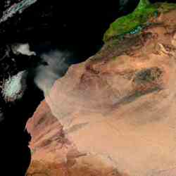
Dust storms are being mapped for the ESA-led Epidemio project. Image credit: ESA
Click to enlarge
All those eyes in the sky are coming in handy for purposes scientists never imagined. Now researchers from ESA are using Envisat data to track places on Earth where disease epidemics could get started. The team was able to link the outbreak of diseases in Africa with dryness and drought. So far they've been able to track regions which are dry, which contribute to the spread of meningitis. Aid workers can then target these regions to give vaccinations and provide early warnings.
The amount of data acquired by satellites is increasing at an exponential rate, and researchers are learning about the value of this data in fighting epidemic outbreaks as a result of the ESA's Epidemio project.
"I was negative about the role satellites could play in addressing epidemics, but now I am positive," Penelope Vernatsou of the Swiss Tropical Institute in Switzerland said.
The ESA-funded Epidemio project was developed in January 2004 to illustrate the benefits of remote-sensing data for studying, monitoring and predicting epidemic outbreaks.
By using data which focuses on a region's landscape ? rainfall, vegetation, water bodies, elevation, dust mapping and temperature ? researchers are able to pinpoint climatic conditions which are favourable for harbouring various epidemic hosts, indicating where people are at greatest risk.
As the project draws to completion, epidemiologists and data users gathered in Frascati, Italy, at the 'Earth Observation in Epidemiology Workshop', on 8-10 March 2006, to report on how Earth observation (EO) has benefited the field of epidemiology.
Ghislain Moussavou of the Gabon-based International Centre for Medical Research (CIRMF) began studying Ebola haemorrhagic fever, which can cause runaway internal and external bleeding in humans and apes, in Congo and Gabon in the hope of spotting particular environmental characteristics associated with infected sites.
Combining ESA Envisat satellite data, under the Epidemio project, on water bodies, forest cover and digital elevation models (DEMs) with field results, Moussavou and his team were able to link the epidemic with dryness and drought.
Moussavou said determining these factors will allow officials to tell the villagers in the area that current conditions for transmission are high, and that they need to take extra precautions. "Because there are no medicines to prevent or cure Ebola, predictions and prevention are necessary."
Dry conditions are also favourable for the spread of meningitis, an inflammation of the brain and spinal cord lining. Epidemics nearly always start in the early part of the dry season when it is hot and dusty. For this reason, ESA has been providing dust maps for high-risk areas to aid in implementing early warning systems.
Christelle Barbey of Silogic, in France, is currently involved in an Epidemio project to provide wind blown dust maps for Africa. Although her final results are still coming in, she was able to detect 100 percent of known dust events, using MeteoSat data, and determine that dust maps do correspond to a user need to contribute to meningitis prevention.
The Epidemio project - funded by the Data User Element of the ESA Earth Observation Envelope Programme - concludes its two-year mission in April 2006, but the groundwork it has laid will aid users in the continuance of their research and allow new projects to be undertaken.
Giuseppe Ottavianelli and Aude de Clercq of the HISTAR Solutions in the Netherlands are currently working on a project, backed by ESA business incubator financing, to confirm the onset of malaria epidemics in Africa, as predicted by remote sensing data.
They have designed a prototype of a sensor located in a box that detects mosquitoes as they fly overhead. The data collected by the sensor is then processed by a program inside the box, which will be placed in hat hutches in high-risk African villages, and indicates the species and numbers of the mosquitoes detected.
Malaria is transferred by the female mosquito of the species Anopheles, so if the sensor detects her presence in high numbers, public officials will be alerted so that preventive measures can be put into place.
ESA Portal