Towering Cliffs at the Edge of Olympus Mons
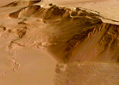
The eastern scarp of the Olympus Mons volcano. Image credit: ESA Click to enlarge
This photograph was taken by ESA’s Mars Express spacecraft. It shows the eastern edge of the Olympus Mons volcano on Mars – the biggest mountain the Solar System. These huge cliffs tower above the relatively flat eastern plains around the mountain. The region has been covered repeatedly by lava flows, as recently as 200 million years ago.
This image, taken by the High Resolution Stereo Camera (HRSC) on board ESA’s Mars Express spacecraft, shows the eastern scarp of the Olympus Mons volcano on Mars.
The HRSC obtained this images during orbit 1089 with a ground resolution of approximately 11 metres per pixel. The image is centred at 17.5 North and 230.5 East. The scarp is up to six kilometres high in places.
The surface of the summit plateau’s eastern flank shows lava flows that have are several kilometres long and a few hundred metres wide.
Age determinations show that they are up to 200 million years old, in some places even older, indicating episodic geological activity.
The lowland plains, seen here in the eastern part of the image (bottom), typically have a smooth surface.
Several channel-like features are visible which form a broad network composed of intersecting and ‘anastomosing’* channels that are several kilometres long and up to 40 metres deep. (*Anastomising means branching extensively and crossing over one another, like veins on the back of your hand.)
Several incisions suggest a tectonic control, others show streamlined islands and terraced walls suggesting outflow activity.
Age determinations show that the network-bearing area was geologically active as recent as 30 million years ago.
Between the edge of the lowland plains and the bottom of the volcano slope, there are ‘wrinkle ridges’ which are interpreted as the result of compressional deformation. In some places, wrinkle ridges border the arch-like terraces at the foot of the volcano slope.
The colour scenes have been derived from the three HRSC-colour channels and the nadir channel. The perspective views have been calculated from the digital terrain model derived from the stereo channels.
The 3D anaglyph image was calculated from the nadir and one stereo channel.
Original Source: ESA Portal
Recent Posts
The Universe Could Be Filled With Ultralight Black Holes That Can't Die
Steven Hawking famously calculated that black holes should evaporate, converting into particles and energy over…
Starlink on Mars? NASA Is Paying SpaceX to Look Into the Idea
NASA has given the go-ahead for SpaceX to work out a plan to adapt its…

Did You Hear Webb Found Life on an Exoplanet? Not so Fast…
The JWST is astronomers' best tool for probing exoplanet atmospheres. Its capable instruments can dissect…
Vera Rubin’s Primary Mirror Gets its First Reflective Coating
First light for the Vera Rubin Observatory (VRO) is quickly approaching and the telescope is…
Two Stars in a Binary System are Very Different. It's Because There Used to be Three
A beautiful nebula in the southern hemisphere with a binary star at it's center seems…
The Highest Observatory in the World Comes Online
The history of astronomy and observatories is full of stories about astronomers going higher and…