Latest Satellite Images of Oil Spill
Satellite image from the Aqua Satellite on May 4, 2010 showing the oil spill in the Gulf of Mexico. Credit: NASA/Goddard/MODIS Rapid Response Team
[/caption]
NASA’s Aqua satellite flew over the oil slick in the Gulf of Mexico on May 4, at 18:50 UTC, or 2:50 p.m. EDT, and the Moderate Imaging Spectroradiometer, or MODIS, instrument captured this visible-light image. The bulk of the spill appears as a dull gray area southeast of the Mississippi Delta. The spill is the result of an explosion on April 20, 2010 which destroyed the Deepwater Horizon oil platform operating in the Gulf 80 kilometers (50 miles) offshore. Many of the workers on the platform were killed, and about 5,000 barrels of oil per day has been released into the water. The huge oil slick is being carried towards the Mississippi River Delta. Weather and currents have cooperated so far to keep the slick away from sensitive wetlands and wildlife areas along the Gulf Coast, and oil has come ashore in a few spots in Louisiana. However, the oil is expected to reach the Louisiana, Alabama, and Mississippi shores by Thursday, May 6, and cause considerable damage to property and endanger wildlife and habitats.
See more images below, including one from the International Space Station taken today.
This image was taken on May 5 by astronaut Soichi Noguchi on board the ISS, and posted on Twitter.
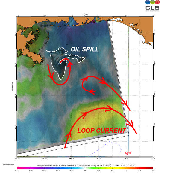
This image from ESA’s Envisat radar, shows sea surface roughness and current flow information. Not only could the slick head towards the US mainland, but there have been fears that the Loop Current in the Gulf of Mexico could catch the oil slick and drag it south towards coral reefs in the Florida Keys. If that were to happen, the oil could flow into the Gulf Stream and be carried up to the US East Coast.
But so far, the loop does not appear to be catching the oil slick.
Another MODIS image from May 1 shows the oil slick as a tangle of dull gray on the ocean surface, made visible to the satellite sensor by the sun’s reflection on the ocean surface. At this point, the oil slick was southeast of the Mississippi Delta.
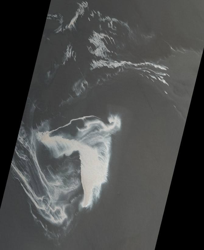
The Advanced Spaceborne Thermal Emission and Reflection Radiometer (ASTER) instrument on NASA’s Terra spacecraft captured this image of the growing oil spill in the Gulf of Mexico on May 1, 2010. The image is located at 29.0 degrees north latitude, 88.3 degrees west longitude and covers an area measuring 79.1 by 103.9 kilometers (49 by 64.4 miles), about 32 kilometers (20 miles) west of the mouth of the Mississippi River delta. No land is visible in the image.
The varying shades of white in the image reflect different thicknesses of oil (the whiter, the thicker the oil). The source of the oil spill is visible as the bright white area in the bottom center of the image. The thickest part of the spill extends vertically from it, appearing somewhat like the ash plume of an erupting volcano. The wispy patterns of the oil spill reflect the transport of the oil by waves and currents.
Sources: NASA Earth Observatory, ESA
Recent Posts
Two Stars in a Binary System are Very Different. It's Because There Used to be Three
A beautiful nebula in the southern hemisphere with a binary star at it's center seems…
The Highest Observatory in the World Comes Online
The history of astronomy and observatories is full of stories about astronomers going higher and…

Is the JWST Now an Interplanetary Meteorologist?
The JWST keeps one-upping itself. In the telescope's latest act of outdoing itself, it examined…
Solar Orbiter Takes a Mind-Boggling Video of the Sun
You've seen the Sun, but you've never seen the Sun like this. This single frame…
What Can AI Learn About the Universe?
Artificial intelligence and machine learning have become ubiquitous, with applications ranging from data analysis, cybersecurity,…
Enceladus’s Fault Lines are Responsible for its Plumes
The Search for Life in our Solar System leads seekers to strange places. From our…